Showing 37 items matching "silver street bridge"
-
 Eltham District Historical Society Inc
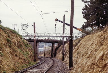
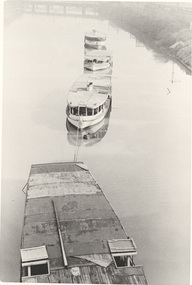
Photograph - Colour Print, Russell Yeoman, Upgrading the old Silver Street Railway Bridge, Eltham, c.1988
... Upgrading the old Silver Street Railway Bridge, Eltham......Silver Street Bridge...Original timber bridge built in 1901 when railway was introduced to Eltham being demolished and replaced with a new concrete structure Bridge bridge construction Eltham Overpass railways silver street Silver Street Bridge Colour photograph Upgrading the old Silver Street Railway Bridge, Eltham Photograph Colour Print Russell Yeoman ...Original timber bridge built in 1901 when railway was introduced to Eltham being demolished and replaced with a new concrete structureColour photographbridge, bridge construction, eltham, overpass, railways, silver street, silver street bridge -
 Eltham District Historical Society Inc
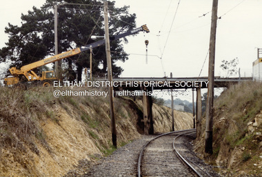
Photograph - Colour Print, Russell Yeoman, Upgrading the old Silver Street Railway Bridge, Eltham, c.1988
... Upgrading the old Silver Street Railway Bridge, Eltham......Silver Street Bridge...Original 1901 wooden railway bridge in process of being upgraded to a new concrete bridge railways bridges silver street eltham Railway Bridge Silver Street Bridge Colour photograph Upgrading the old Silver Street Railway Bridge, Eltham Photograph Colour Print Russell Yeoman ...Original 1901 wooden railway bridge in process of being upgraded to a new concrete bridgeColour photographrailways, bridges, silver street, eltham, railway bridge, silver street bridge -
 Eltham District Historical Society Inc
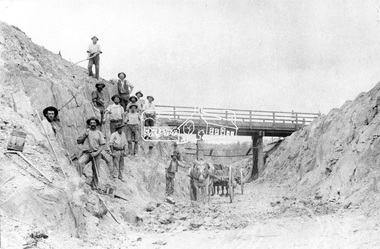
Negative - Photograph, Construction of Railway Line, Greensborough to Eltham, 1901
... ...silver street bridge...The Silver Street Bridge, 1901 Butty Gang workers excavate a rock cutting near the Silver Street bridge prior to laying of track. ...Eltham District Historical Society Inc 728 Main Rd Eltham melbourne The Silver Street Bridge, 1901 Butty Gang workers excavate a rock cutting near the Silver Street bridge prior to laying of track. ...The Silver Street Bridge, 1901 Butty Gang workers excavate a rock cutting near the Silver Street bridge prior to laying of track. The Butty Gang system versus the Contract System was subject to public debate regarding cost benefits at the time of the Eltham line construction. Butty gang workers were a group of men who take a contract for a part of a work, as in the construction of railroads, etc., the proceeds being equally divided between them, with something extra to the foreman. Some hold picks, a couple of horses and carts are lined up probably for carting the broken rock away, dirt, rocks and shale lay at the bottom. A pair of small wooden buckets are evident, most likley to provide drinking water. The timber Silver Street bridge crosses the cutting in the background. The opening of the railway line from Heidelberg to Eltham took place on the 6th June 1902. Similiar to 810. Source: Mrs. Dandy, Montmorency and Miss McColl, 8 Anderson St., HeidelbergThis photo forms part of a collection of photographs gathered by the Shire of Eltham for their centenary project book,"Pioneers and Painters: 100 years of the Shire of Eltham" by Alan Marshall (1971). The collection of over 500 images is held in partnership between Eltham District Historical Society and Yarra Plenty Regional Library (Eltham Library) and is now formally known as the 'The Shire of Eltham Pioneers Photograph Collection.' It is significant in being the first community sourced collection representing the places and people of the Shire's first one hundred years.Digital image 120 format B&W negativeshire of eltham pioneers photograph collection, eltham, railway workers, 1901, butty gang, overpass, railway construction, railway line construction, silver street bridge -
 Eltham District Historical Society Inc
Album - Photograph, J.A. McDonald, Eltham-Greensborough Road, 18 Oct. 1956
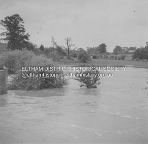
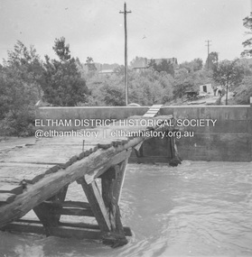
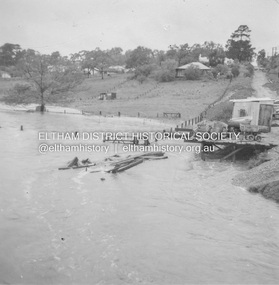
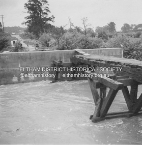
... Street Bridge...Eltham...Eltham-Greensborough Road...1956-10-18...Diamond Creek (Creek)...floods...Floodwater...Hill property...Silver...Street Bridge across the present day Eltham Skatepark. The shed visibile in the distance is directly opposite Brisbane Street where it used to run into Susan Street but now turns the corner. To the right of the shes is the site for present-dayHarris Plumbing which was formerly occupied by Sibbel Builders; to the left the site now occupied by Bunnings. At the skyline to the right of centreeline is a gap in the trees where the railway line runs. The Silver...Street Bridge across the present day Eltham Skatepark. The shed visibile in the distance is directly opposite Brisbane Street where it used to run into Susan Street but now turns the corner. To the right of the shes is the site for present-dayHarris Plumbing which was formerly occupied by Sibbel Builders; to the left the site now occupied by Bunnings. At the skyline to the right of centreeline is a gap in the trees where the railway line runs. The Silver ...Bridge Street Bridge Flooding on Hill’s property 18th October 1956 This view is looking west north west from the Bridge Street Bridge across the present day Eltham Skatepark. The shed visibile in the distance is directly opposite Brisbane Street where it used to run into Susan Street but now turns the corner. To the right of the shes is the site for present-dayHarris Plumbing which was formerly occupied by Sibbel Builders; to the left the site now occupied by Bunnings. At the skyline to the right of centreeline is a gap in the trees where the railway line runs. The Silver Street bridge over the railway is visible. Beware!.. our rivers are rising (1956, October 19). The Argus (Melbourne, Vic. : 1848 - 1957), p. 1. Retrieved August 24, 2022, from http://nla.gov.au/nla.news-article84392304Record of various Shire of Eltham infrastructure works undertaken during the period of 1952-1962 involving bridge and road reconstruction projects, sometimes with Eltham Shire Council Project Reference numbers quoted. It was during this period that a number of significant improvements were made to roads and new bridges constructed within the shire that remain in place as of present day (2022). In many situations, the photos provide a tangible visible record of infrastructure that existed throughout the early days of the Shire. The album was put together by or under the direction of the Shire Engineer, J.A. McDonald.infrastructure, road construction, shire of eltham, bridge construction, bridge street bridge, eltham, eltham-greensborough road, 1956-10-18, diamond creek (creek), floods, floodwater, hill property, silver street bridge -
 Eltham District Historical Society Inc
Folder, John Handfield
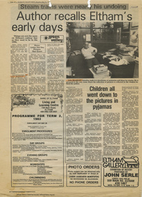
... ...Silver Street Bridge...Copeland Edward Gadd Ernest James Andrew Fanny Withers (nee Flinn) Hubert Rutter Jack Baker Jack Ryan June Rutter Margery Withers Newsagency Oakley Ronnie Baker Silver Street Bridge Tessie Baker Walter Withers Burke and Wills Father G K Tucker Frederick Oliver Handfield Friends and Brothers (book) Muriel Elizabeth Handfield (nee Cochran) SS Victoria St Laurence and Community Aid Abroad Stanhope House Theodore Louis Hopton Handfield Book review Folder of information on John Handfield, author, Eltham John Handfield Folder ...1. News clipping: Author recalls Eltham's early days; story by Linley Hartley, photo by Ron Grant; Diamond Valley News, Thursday, May 24, 1983, p26 (On reverse side, p25, "A pot for every purpose" about potter Joan Armfield with references to artis Davd Armfield) 2. Three pages typed copy of John Handfield's original letter to Blanche Shallard (of the Shire of Eltham Historical Society), 16 May 1989 detailing the Handfield family's life in Eltham and various personalities between their arrival in 1919 and departure in 1928. With a postscript that John Handfield returned in 1961 to a house designed by friend Robin Boyd and built 1961. At the time of the letter John and Esta Handfield had been the only owners. 3. Note from John Handfield to Ron Smith about a proposed talk (to the Historical Society?) to tell the story about the writing of Friends and Brothers. Proposed title of talk "You Never Know What's Around The Corner" plus several copies of book reviews • Photocopy of news clipping; The rector who created a vision; Review by Bishop Holland; Newcastle Morning Herald, c.1980 - Book review of FRIENDS AND BROTHERS, The Life of Father Tucker, Founder of the Brotherhood of St Laurence and Community Aid Abroad, by John Handfield, Hyland House Publishing Pty Ltd • Photocopy of news clipping; The clergyman whose monuments continue to do good; Review by Geoffrey Hutton; Publication unknown, c.1980 - Book review of FRIENDS AND BROTHERS, The Life of Father Tucker, Founder of the Brotherhood of St Laurence and Community Aid Abroad, by John Handfield, Hyland House Publishing Pty Ltd • Photocopy of news clipping; Helper of the defeated; Review by Sandy Murray; Publication unknown, c.1980 - Book review of FRIENDS AND BROTHERS, The Life of Father Tucker, Founder of the Brotherhood of St Laurence and Community Aid Abroad, by John Handfield, Hyland House Publishing Pty Ltd • Photocopy of news clipping; Friends and Brothers by John Handfield; Review by Bishop James Grant; Publication unknown, c.1980 - Book review of FRIENDS AND BROTHERS, The Life of Father Tucker, Founder of the Brotherhood of St Laurence and Community Aid Abroad, by John Handfield, Hyland House Publishing Pty Ltd • Photocopy of news clipping; Off and running on his third career by Stuart Sayers; Writers & Readers, The Age, Saturday 17 January 1981 • Photocopy of news clipping; Determined to succeed; Review by Roy Cassin; The West Australian, n.d. - Book review of FRIENDS AND BROTHERS, The Life of Father Tucker, Founder of the Brotherhood of St Laurence and Community Aid Abroad, by John Handfield, Hyland House Publishing Pty LtdFolder of information on John Handfield, author, Elthamjohn handfield, joan armfield, david armfield, handfield family, eltham, 16 homestead road, handfield house, anne hunniford, dave lyon, esta handfield, mechanics insitute, mr bond, rechabite hall, robin boyd, rutter family, bishop reginald stephen, clem christesen, desmond annear, dr kent hughes, ethel boake, handfield street, john harcourt, kooringoorama, lady longstaff, nina christesen, peter street, shillinglaw farm, sir john longstaff, stanhope, yarra braes, a. copeland, alf baker, baker's cottage, ballakian, belackian, beulah alice rutter, bill withers, bird brothers cash grocer and fruiterer, blacksmith, burgoyne grocery store, butcher, david rutter, donald rutter, e. copeland, edward gadd, ernest james andrew, fanny withers (nee flinn), hubert rutter, jack baker, jack ryan, june rutter, margery withers, newsagency, oakley, ronnie baker, silver street bridge, tessie baker, walter withers, burke and wills, father g k tucker, frederick oliver handfield, friends and brothers (book), muriel elizabeth handfield (nee cochran), ss victoria, st laurence and community aid abroad, stanhope house, theodore louis hopton handfield, book review -
 Eltham District Historical Society Inc
Album - Photograph Album, J.A. McDonald, Bridge and Road Reconstruction Works, Shire of Eltham, 1952-1962
... Bridge...Paul Creek Road...Paul Krafeznk...Pinnacle Lane...Plaques...Plenty River Trail...Plenty River...Presbyterian Church...Prof Donald Thomson...Pryor Street...railway crossing...Railway Parade...Rattray Road...Reconstruction works...Reichelt Avenue...Research (Vic.)...Research Oval...Road construction...Rymers Corner...shire of eltham...Shire of Whittlesea...Silvan Road Bridge...Silver...Jolly Kangaroo Ground Kangaroo Ground-Queenstown Road Kangaroo Ground-St Andrews Road Lilydale Shire Office Long Gully Bridge Long Gully Creek Long Gully Road Long Gully Lower Plenty Bridge Lower Plenty Footbridge Lower Plenty Oval Lower Plenty Road Lower Plenty Main Road Methodist Church Montmorency Mount Pleasant Road New Holland Old Healesville Road Opening Ceremony Oxley Bridge Para Road Paul Creek Bridge Paul Creek Road Paul Krafeznk Pinnacle Lane Plaques Plenty River Trail Plenty River Presbyterian Church Prof Donald Thomson Pryor Street railway crossing Railway Parade Rattray Road Reconstruction works Reichelt Avenue Research (Vic.) Research Oval Road construction Rymers Corner shire of eltham Shire of Whittlesea Silvan Road Bridge Silver ...J.A. McDonald produced this record in the course of his responsibilities as Shire Engineer for Eltham Shire Council.Record of various Shire of Eltham infrastructure works undertaken during the period of 1952-1962 involving bridge and road reconstruction projects, sometimes with Eltham Shire Council Project Reference numbers quoted. It was during this period that a number of significant improvements were made to roads and new bridges constructed within the shire that remain in place as of present day (2022). In many situations, the photos provide a tangible visible record of infrastructure that existed throughout the early days of the Shire. The album was put together by or under the direction of the Shire Engineer, J.A. McDonald.a. gillies, alistair knox park, benchmark studies, bend of islands, blease road, box hill state school, box hill teachers college, box hill tip, bridge construction, bridge street bridge, bridge, brisbane street, brougham steet, bulldozer, cecil street, charis pelling, cherry tree road, city of preston, cr. a. brinkkotter, cr. charis pelling, cranes, cromwell street, diamond creek (creek), diamond street, dixons creek bridge, dixon's creek road, drott, eltham leisure centre, eltham north, eltham police station, eltham, eltham-yarra glen road, f. wood, fitzsimons lane bridge, flat rock road, flood damage, floods, floodwater, footpaths and gutters, ford service garage, g. blair, garden hill, glen park bridge, glenauburn road, grand hotel, haldane road, healesville, healesville-yarra glen road, heidelberg-kinglake road, henley road bridge, henley road, hill property, hurstbridge water scheme, hurstbridge, hurstbridge-arthurs creek road, infrastructure, j. jolly, kangaroo ground, kangaroo ground-queenstown road, kangaroo ground-st andrews road, lilydale shire office, long gully bridge, long gully creek, long gully road, long gully, lower plenty bridge, lower plenty footbridge, lower plenty oval, lower plenty road, lower plenty, main road, methodist church, montmorency, mount pleasant road, new holland, old healesville road, opening ceremony, oxley bridge, para road, paul creek bridge, paul creek road, paul krafeznk, pinnacle lane, plaques, plenty river trail, plenty river, presbyterian church, prof donald thomson, pryor street, railway crossing, railway parade, rattray road, reconstruction works, reichelt avenue, research (vic.), research oval, road construction, rymers corner, shire of eltham, shire of whittlesea, silvan road bridge, silver street bridge, silver street, sir dallas brooks, smedley property, st andrews, steels creek, susan street, tarrawarra, tony carberry, uniting church, upper yarra dam, upper yarra reservoir, w.e. wolf, waterfall property, watsons creek, wattletree road bridge, wattletree road, wattletree road bridge, worlingworth, yarra glen, york street, yow yow creek -
 Eltham District Historical Society Inc
Album - Photograph, J.A. McDonald, Eltham-Greensborough Road, 18 Oct. 1956
... Street Bridge...Eltham...Eltham-Greensborough Road...1956-10-18...Diamond Creek (Creek)...floods...Floodwater...Silver...Infrastructure Road construction shire of eltham bridge construction Bridge Street Bridge Eltham Eltham-Greensborough Road 1956-10-18 Diamond Creek (Creek) floods Floodwater Silver Street Bridge Black and white photo print (location of negative unknown) Adhered to a page in an album of 78 foolscap pages containing a sequence of photos, adhered via glue or sticky tape, with typed or handwritten headings and captions in pencil. ...Bridge Street Bridge Flood level on Greensborough pier 18th October 1956 View looking west across the Diamond Creek and tempoary walking access bridge towards intersection of Susan Street. The building visible on centreeline is the present-day SES facility. Beware!.. our rivers are rising (1956, October 19). The Argus (Melbourne, Vic. : 1848 - 1957), p. 1. Retrieved August 24, 2022, from http://nla.gov.au/nla.news-article84392304Record of various Shire of Eltham infrastructure works undertaken during the period of 1952-1962 involving bridge and road reconstruction projects, sometimes with Eltham Shire Council Project Reference numbers quoted. It was during this period that a number of significant improvements were made to roads and new bridges constructed within the shire that remain in place as of present day (2022). In many situations, the photos provide a tangible visible record of infrastructure that existed throughout the early days of the Shire. The album was put together by or under the direction of the Shire Engineer, J.A. McDonald.infrastructure, road construction, shire of eltham, bridge construction, bridge street bridge, eltham, eltham-greensborough road, 1956-10-18, diamond creek (creek), floods, floodwater, silver street bridge -
 Eltham District Historical Society Inc
Album - Photograph, J.A. McDonald, Eltham-Greensborough Road, 18 Oct. 1956
... Street Bridge...Eltham...Eltham-Greensborough Road...1956-10-18...Diamond Creek (Creek)...floods...Floodwater...Silver...Infrastructure Road construction shire of eltham bridge construction Bridge Street Bridge Eltham Eltham-Greensborough Road 1956-10-18 Diamond Creek (Creek) floods Floodwater Silver Street Bridge Alistair Knox Park Waterfall property Black and white photo print (location of negative unknown) Adhered to a page in an album of 78 foolscap pages containing a sequence of photos, adhered via glue or sticky tape, with typed or handwritten headings and captions in pencil. ...Bridge Street Bridge Flooding on Waterfall’s Estate 18th October 1956 Looking east up to Main Road over what is now present-day Alistair Knox Park Beware!.. our rivers are rising (1956, October 19). The Argus (Melbourne, Vic. : 1848 - 1957), p. 1. Retrieved August 24, 2022, from http://nla.gov.au/nla.news-article84392304Record of various Shire of Eltham infrastructure works undertaken during the period of 1952-1962 involving bridge and road reconstruction projects, sometimes with Eltham Shire Council Project Reference numbers quoted. It was during this period that a number of significant improvements were made to roads and new bridges constructed within the shire that remain in place as of present day (2022). In many situations, the photos provide a tangible visible record of infrastructure that existed throughout the early days of the Shire. The album was put together by or under the direction of the Shire Engineer, J.A. McDonald.infrastructure, road construction, shire of eltham, bridge construction, bridge street bridge, eltham, eltham-greensborough road, 1956-10-18, diamond creek (creek), floods, floodwater, silver street bridge, alistair knox park, waterfall property -
 Eltham District Historical Society Inc
Album - Photograph, J.A. McDonald, Eltham-Greensborough Road, 18 Oct. 1956
... Street Bridge...Eltham...Eltham-Greensborough Road...1956-10-18...Diamond Creek (Creek)...floods...Floodwater...Silver...Infrastructure Road construction shire of eltham bridge construction Bridge Street Bridge Eltham Eltham-Greensborough Road 1956-10-18 Diamond Creek (Creek) floods Floodwater Silver Street Bridge Black and white photo print (location of negative unknown) Adhered to a page in an album of 78 foolscap pages containing a sequence of photos, adhered via glue or sticky tape, with typed or handwritten headings and captions in pencil. ...Bridge Street Bridge Flood level on Eltham pier 18th October 1956 Looking west across the Diamond Creek to Susan Street intersection Beware!.. our rivers are rising (1956, October 19). The Argus (Melbourne, Vic. : 1848 - 1957), p. 1. Retrieved August 24, 2022, from http://nla.gov.au/nla.news-article84392304Record of various Shire of Eltham infrastructure works undertaken during the period of 1952-1962 involving bridge and road reconstruction projects, sometimes with Eltham Shire Council Project Reference numbers quoted. It was during this period that a number of significant improvements were made to roads and new bridges constructed within the shire that remain in place as of present day (2022). In many situations, the photos provide a tangible visible record of infrastructure that existed throughout the early days of the Shire. The album was put together by or under the direction of the Shire Engineer, J.A. McDonald.infrastructure, road construction, shire of eltham, bridge construction, bridge street bridge, eltham, eltham-greensborough road, 1956-10-18, diamond creek (creek), floods, floodwater, silver street bridge -
 Marysville & District Historical Society
THE TRIANGLE NEWS-VOL 37 NO 24-JUNE 25 2010
... Marysville & District Historical Society 39 Darwin Street Marysville yarra-valley-and-the-dandenong-ranges marysville victoria australia lions change over president marysville & district lions club stonelea resort governor david jones marysville golfers avenel silver salver event cancelled torrential rains at golfing event advertisements alexandra cinema breakaway bridge being assessed acheron bridge murrindindi council figjam ralley mountain motorsports australian auto sport alliance aasa THE TRIANGLE NEWS-VOL 37 NO 24-JUNE 25 2010 ...marysville, victoria, australia, lions change over president, marysville & district lions club, stonelea resort, governor david jones, marysville golfers, avenel silver salver event cancelled, torrential rains at golfing event, advertisements, alexandra cinema, breakaway bridge being assessed, acheron bridge, murrindindi council, figjam ralley, mountain motorsports, australian auto sport alliance, aasa -
 Ballarat Fire Brigade
Trowel, just prior to 01/01/1864
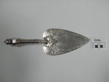
... Ballarat Fire Brigade Corner Barkly & East Streets Ballarat East goldfields Trowel was presented to Captain Spark by honourable secretary Mr Charles Dyte on 1/1/1864 to lay the foundation stone of the watchtower and belfrey of the Ballarat fire station. Trowel was made by Mr. Bennett of Bridge street and fashioned on the trowel used by Mr. Fraser M.L.C. when laying the foundation stone of the St. Kilda town hall ballarat fire brigade captain foundation stone trowel colonial silversmith silver ...Trowel was presented to Captain Spark by honourable secretary Mr Charles Dyte on 1/1/1864 to lay the foundation stone of the watchtower and belfrey of the Ballarat fire station. Trowel was made by Mr. Bennett of Bridge street and fashioned on the trowel used by Mr. Fraser M.L.C. when laying the foundation stone of the St. Kilda town hallhand engraved sterling silver ceremonial trowel. engraving is floral design on blade. handle is hollow, octaganol with leaf pattern and greek meander patternHallmarked on underside - emu, "WE" (letters), kangarooballarat fire brigade, captain, foundation stone, trowel, colonial silversmith, silver trowel, captain spark, honourable secretary, mr bennet, sterling silver, charles dyte, dyte, spark, 1864, watchtower and belfrey, tower, watchtower, belfrey -
 Eltham District Historical Society Inc
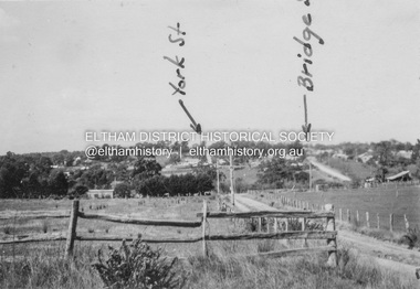
Album - Photograph, J.A. McDonald, Eltham-Diamond Creek Road, 21 Oct. 1953
... bridge construction...Brisbane Street...silver...Diamond Street Bridge 21st October, 1953 (showing York St., Bridge St., and Brisbane St in immediate foreground) View from intersection of Silver Street at Brisbane Street looking east. ...Eltham District Historical Society Inc 728 Main Rd Eltham melbourne Diamond Street Bridge 21st October, 1953 (showing York St., Bridge St., and Brisbane St in immediate foreground) View from intersection of Silver Street at Brisbane Street looking east. ...Diamond Street Bridge 21st October, 1953 (showing York St., Bridge St., and Brisbane St in immediate foreground) View from intersection of Silver Street at Brisbane Street looking east. On the far side of Brisbane Street is the site of present-day Bunnings store. At the visible end of Brisbane Street where it turns right it then became Susan Street but today continues to the intersection with Bridge Street.Record of various Shire of Eltham infrastructure works undertaken during the period of 1952-1962 involving bridge and road reconstruction projects, sometimes with Eltham Shire Council Project Reference numbers quoted. It was during this period that a number of significant improvements were made to roads and new bridges constructed within the shire that remain in place as of present day (2022). In many situations, the photos provide a tangible visible record of infrastructure that existed throughout the early days of the Shire. The album was put together by or under the direction of the Shire Engineer, J.A. McDonald.infrastructure, road construction, shire of eltham, 1953-10-21, bridge construction, brisbane street, silver street, susan street, york street -
 Eltham District Historical Society Inc
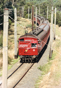
Photograph, George Coop, A Princes Bridge bound Tait (Red Rattler) train viewed from Silver Street railway overpass, Eltham, c. March 1981, c. March 1981
... A Princes Bridge bound Tait (Red Rattler) train viewed from Silver Street railway overpass, Eltham, c. ...Eltham District Historical Society Inc 728 Main Rd Eltham melbourne eltham, george coop collection, hurstbridge railway line, overpass, red rattler, silver street, tait train Kodak Safety 5035 March 1981 process date of print Digital TIFF file Scan of 35mm Kodak Safety 5035 colour transparency A Princes Bridge bound Tait (Red Rattler) train viewed from Silver Street railway overpass, Eltham, c. ...Digital TIFF file Scan of 35mm Kodak Safety 5035 colour transparencyKodak Safety 5035 March 1981 process date of printeltham, george coop collection, hurstbridge railway line, overpass, red rattler, silver street, tait train -
 Eltham District Historical Society Inc
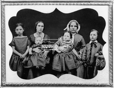
Negative - Photograph, Members of the Hill family, early Eltham settlers, c.1860
... Bridge Street, Eltham, 4 June 1966 and includes copy of her note identifying the people. Daguerreotypes were one of the first forms of early photographs. They initially appeared in Europe in 1839 and were produced in large numbers to the early 1850s but were superseded by more modern and flexible forms of technology by 1860. The photo was usually formed on a thin copper plate with light sensitve silver...Bridge Street, Eltham, 4 June 1966 and includes copy of her note identifying the people. Daguerreotypes were one of the first forms of early photographs. They initially appeared in Europe in 1839 and were produced in large numbers to the early 1850s but were superseded by more modern and flexible forms of technology by 1860. The photo was usually formed on a thin copper plate with light sensitve silver ...Mrs Georgina Hill (wife of Henry), nee Reynolds (of Research, Vic.) in cap [possibly misidentified by donor - see note below] with Mrs Isaac Hill and her children (left to right) Amelia Hill, (born 1853) Mrs Isaac Hill with baby Isaac (born 1860, Eltham) on her lap. Mary Jane Hill (born 1857, Eltham) seated on Mrs Henry Hill's lap and Bob Hill. The Hill family were early settlers of the Eltham area. Daguerreotype photo enclosed in a leather bound clam shell box with felt lining and gold trim. Donated by Mrs Ivy Edna Hill, 4/1 Bridge Street, Eltham, 4 June 1966 and includes copy of her note identifying the people. Daguerreotypes were one of the first forms of early photographs. They initially appeared in Europe in 1839 and were produced in large numbers to the early 1850s but were superseded by more modern and flexible forms of technology by 1860. The photo was usually formed on a thin copper plate with light sensitve silver iodide. They have a mirror-like appearance and the image itself was mirrored. They were usually inserted into a case or frame made of wood bound in leather or velvet and cost about one guinea in Australia, the equivalent of a week's wages. With the advent of the gold-rush and growing population came an increase in numbers of photographers both studio and travelling. The daguerreotype process was protected by patents and could only result in a single image from which no copies could be made. With new technology involving wet colloidion glass plate negatives and albumen paper prints of which multiple copies could be produced at significantly reduced cost, the dauguerreotype quickly fell out of favour. An accompanying note with the photo written by Edna Hill of 4/1 Bridge Street Eltham dated 4 June 1966 states: "Dear Mr Watson, I think the enclosed old time photograph will be of interest to you. It would have been taken about 1860. The two ladies are the wives of the original pioneers of the Hill family. The one in the cap was the wife of Henry Hill, the other of Isaac Hill. The children are those of Mrs Isaac Hill, and grandchildren to Henry Hill. The little girl on the left is Amelia, the baby Isaac, the second girl is Mary Jane, and the boy on the right is Bob Hill. They grew up tobe Uncles and Aunts of my late husband. I greatly appreciated a letter received a few months ago per Cr Pelling, from the Shillinglaw Cottage Committee. Yours sincerely, Edna Hill" Victorian birth registrations show Mary Jane Hill was born 1857 in Eltham (9879 / 1857) and Isaac Hill at Eltham in 1860 (1972/1860) NOTE: Mrs Isaac Hill was Ellen Fitzsimons (1834-1863), mother to Henry Hill. Mrs Georgina Hill, wife of Henry cannot be the lady in the cap as she was not born till 1864. Georgina Reynolds (1864-1927) married Henry Hill (1862-1948) in 1884. This lady has significant wrinkling of the face, especially around her mouth. It is possible that she is the mother of Mrs Isaac Hill (Ellen Fitzsimons) who was Isabella Fitzsimons (nee Ferguson).This photo forms part of a collection of photographs gathered by the Shire of Eltham for their centenary project book,"Pioneers and Painters: 100 years of the Shire of Eltham" by Alan Marshall (1971). The collection of over 500 images is held in partnership between Eltham District Historical Society and Yarra Plenty Regional Library (Eltham Library) and is now formally known as 'The Shire of Eltham Pioneers Photograph Collection.' It is significant in being the first community sourced collection representing the places and people of the Shire's first one hundred years.Digital image 4 x 5 inch B&W Negsepp, shire of eltham pioneers photograph collection, eltham, hill family, research (vic.), women, amelia hill, bob hill, daguerreotype, early settlers, georgina hill (nee reynolds), isaac hill, mary jane hill, mrs henry hill, mrs isaac hill, ellen hill (nee fitzsimons), isabella fitzsimons (nee ferguson) -
Port Melbourne Historical & Preservation Society
Domestic object - Coasters, Port Melbourne Bowling Club, 1970s
... Port Melbourne Historical & Preservation Society Port Melbourne Town Hall 333 Bay Street Port Melbourne melbourne From the collection of the late Fred Winduss Sport - Lawn Bowls Frederick Robert WINDUSS Port Melbourne Bowling Club Four aluminium coasters from the collection of the late Fred WINDUSS - two gold plated and two silver plated, with Port Melbourne Bowling Club insignia; mounted on blue felt in a black card pouch. Impression of Yarra River with West Gate Bridge ...From the collection of the late Fred WindussFour aluminium coasters from the collection of the late Fred WINDUSS - two gold plated and two silver plated, with Port Melbourne Bowling Club insignia; mounted on blue felt in a black card pouch. Impression of Yarra River with West Gate Bridge in foreground and City in background, edge of a bowl on right handsport - lawn bowls, frederick robert winduss, port melbourne bowling club -
 Bendigo Historical Society Inc.
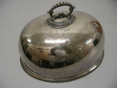
Domestic Object - LARGE MEAT COVER
... History House 11 Mackenzie Street Bendigo goldfields DOMESTIC EQUIPMENT Food storage & preservation meat cover DI500 Mappin Brothers 222 Regent Street and London Bridge Large oval shaped silver plated meat cover with handle and a Lion rampant clutching a sheaf of wheat engraved on one side. ...Large oval shaped silver plated meat cover with handle and a Lion rampant clutching a sheaf of wheat engraved on one side.Mappin Brothers 222 Regent Street and London Bridgedomestic equipment, food storage & preservation, meat cover, di500 -
 Bendigo Historical Society Inc.
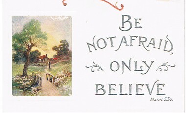
Document - MALONE COLLECTION: GREETING CARDS, 1926
... Street Bendigo goldfields PERSON Greeting cards malone collection Malone Collection Greeting Cards Document. Greeting Cards. Large white card with two holes at the top for hanging. It has a piece of orange cord through it. On the right, printed in silver capitals is: 'Be not afraid only believe Mark. 5.36.'. There is a piece of scroll work on each side of 'only'. On the left is a coloured picture of a brown house with a red roof. In the foreground is a path leading over a bridge ...Document. Greeting Cards. Large white card with two holes at the top for hanging. It has a piece of orange cord through it. On the right, printed in silver capitals is: 'Be not afraid only believe Mark. 5.36.'. There is a piece of scroll work on each side of 'only'. On the left is a coloured picture of a brown house with a red roof. In the foreground is a path leading over a bridge to the house. On each side of the bridgeare flowers. On the left is a tree. Nearer the house, on the path is a man using a hoe or similar.person, greeting cards, malone collection, malone collection, greeting cards -
 Flagstaff Hill Maritime Museum and Village
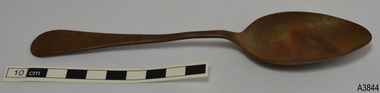
Domestic object - Spoon, Cooper Brothers, 1866-1932
... silver. Cooper Brothers was established in 1866 by brothers Thomas and John William Cooper in High Street, Sheffield. They bought Don Plate Works in 1872. By 1876 they were at Bridge...silver. Cooper Brothers was established in 1866 by brothers Thomas and John William Cooper in High Street, Sheffield. They bought Don Plate Works in 1872. By 1876 they were at Bridge ...This tablespoon was recovered from an unknown shipwreck in the coastal waters of Victoria in the late 1960s to early 1970s. The shipwrecks in the area range from around the 1840s to the early 1930s, and this particular spoon dates from about 1866 to 1932. It is part of the John Chance Collection. This spoon has the embossed names of Pompton and Silver and appears to have other marks that have worn off. The Pompton brand was used on silver flatware made by Cooper Brothers & Sons. Ltd of Sheffield. In Australia the Pompton Silver cutlery was advertised for sale in Sydney in the mid-1920s. The spoon is likely to be plated silver or silver plate, which is a base metal such as nickel or nickel alloy with copper and/or zinc that has been plated or coated with a thin layer of silver. Wear on the metal will cause the base metals to appear through the silver plating. Some manufacturers gave a warranty that the cutlery was ‘white throughout’ but didn’t necessarily say it was solid silver. Cooper Brothers was established in 1866 by brothers Thomas and John William Cooper in High Street, Sheffield. They bought Don Plate Works in 1872. By 1876 they were at Bridge Street and in 1885 they purchased the works at 44 Arundel St Sheffield. In 1895 the firm became Cooper Brothers & Sons Ltd. By 1914 they had branches in London, Sydney, Melbourne and Montreal, advertising as silversmiths, silver cutlers, electroplaters, Britannia Metal smiths and cutlers, particularly spoons and forks. The firm also used the trademarks of DON SILVER, POMPTON SILVER and a logo of a Cooper (barrel maker) in different formats. Cooper Brothers & Sons had a reputation for producing good quality silver and silver plate. In 1900 they registered their Maker’s Mark of the letters ‘CB&s’ within a shield. They also used the Sheffield Assay Hallmark of a Crown. A diagram on a Copper Brothers & Sons, Don Plate Works, advertisement showed three styles of cutlery; No. 393, Old English, and Fiddle. They announced that they were the ‘sole makers of the celebrated “Don” brand of nickel silver spoons and forks’. A burglary in NSW in 1929 listed a stolen flatware set as ‘all Sheffield Silver plate and branded Pompton Silver Works A.1.’. It was ‘guaranteed to wear white throughout’ and was a ‘good, medium quality, nickel silver line’. Cooper Brothers & Sons Ltd. was acquired in 1983 by Frank Cobb & Co. Ltd. Although the spoon is not linked to a particular shipwreck, it is recognised as being historically significant as an example of cutlery either as part of the ship’s flatware service or imported for use in Colonial Victoria in the 19th to early 20th century. The spoon is significant for its association with renowned makers Cooper Brothers of Sheffield, makers of silverware from the 1860s to the 1980s and exporters into the Colonies. The spoon is also significant as it was recovered by John Chance, a diver in Victoria’s coastal waters in the late 1960s to early 1970s. Items that come from several wrecks have since been donated to the Flagstaff Hill Maritime Village’s museum collection by his family, illustrating this item’s level of historical value. Spoon; plated silver tablespoon with brown base metal. Handle is Old English design and is embossed - some marks are worn and unidentifiable. Branded Pompton Silver.Embossed within two rectangular shapes “POMPTON” and “SILVER” (other marks have worn off)flagstaff hill, warrnambool, flagstaff hill maritime museum, maritime museum, shipwreck coast, flagstaff hill maritime village, great ocean road, john chance, cutlery, flatware silver, silver plate, antique flatware, old english flatware pattern, eating utensils, spoon, tablespoon, silverware, dining utensil, cooper brothers, don plate works, pompton silver, sheffield silver -
 The Cyril Kett Optometry Museum
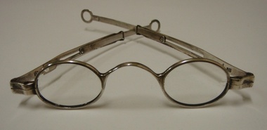
Georgian silver spectacles, early 19th century
... Street Carlton melbourne These silver spectacles are of a design widely used through the early to mid-19th century. They may have been used by several generations after the original owner. They are part of a major donation to the Kett collection by Mrs Wantrup, widow of optometrist Charles Wantrup. These silver spectacles have significance to the collection as part of a major donation to the Kett collection by Mrs Wantrup, widow of optometrist Cyril Wantrup. silver spectacles glasses georgian spectacles Stamped with lion passant and maker's mark 'IP'. Silver oval eye Georgian spectacles with saddle bridge ...These silver spectacles are of a design widely used through the early to mid-19th century. They may have been used by several generations after the original owner. They are part of a major donation to the Kett collection by Mrs Wantrup, widow of optometrist Charles Wantrup.These silver spectacles have significance to the collection as part of a major donation to the Kett collection by Mrs Wantrup, widow of optometrist Cyril Wantrup.Silver oval eye Georgian spectacles with saddle bridge and glass lenses. Sliding sides with small loops at ends for a riband. Partial hallmarks: lion passant and IP (maker's mark)on front and each side.Stamped with lion passant and maker's mark 'IP'.silver, spectacles, glasses, georgian spectacles -
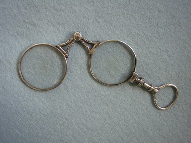 The Cyril Kett Optometry Museum
Silver small lorgnette, unknown, 1850 (estimated)
... Street Carlton melbourne This pretty folding silver lorgnette appears European in styling and may be French. The extensive scratching on the lenses indicates many years of use. This form of lorgnette was popular in the mid to late nineteenth century. This lorgnette is significant to the collection as one of the most ornate. lenses glasses lorgnette folding spectacles Silver folding short handled lorgnette with pivoted bridge and ornamental loop handle. ...This pretty folding silver lorgnette appears European in styling and may be French. The extensive scratching on the lenses indicates many years of use. This form of lorgnette was popular in the mid to late nineteenth century.This lorgnette is significant to the collection as one of the most ornate.Silver folding short handled lorgnette with pivoted bridge and ornamental loop handle. Round convex lenses badly scratched.lenses, glasses, lorgnette, folding spectacles -
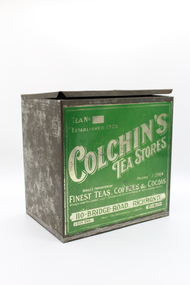 Myrtleford and District Historical Society
c. 1930s
... Street Myrtleford high-country Tea No 290. Colchin's Tea Stores PHONE J2565 Direct Importer of Finest Teas, Coffee & Cocoas Always over the Commonwealth Standard of extract ~Blends to suit individual Tastes! 110 BRIDGE ROAD. RICHMOND.. CITY END Your recommendation favoured MELBOURNE Metal box with a hinged lid, front panel decorated with silver ...Metal box with a hinged lid, front panel decorated with silver lettering and green background.Tea No 290. Colchin's Tea Stores PHONE J2565 Direct Importer of Finest Teas, Coffee & Cocoas Always over the Commonwealth Standard of extract ~Blends to suit individual Tastes! 110 BRIDGE ROAD. RICHMOND.. CITY END Your recommendation favoured MELBOURNE -
 Geelong Naval and Maritime Museum
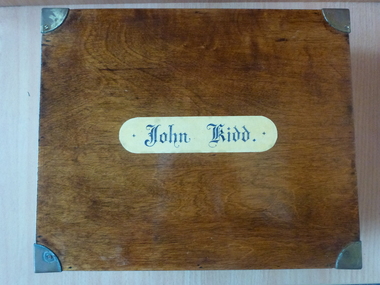
Ditty Box, John Kidd's Ditty Box, c.1915-1930
... Street, Samarai. Postcard: Sydney from Lavender Bay Kerry (Copyright) Sydney. Postcard: "Docks showing cathedral, Bristol BL 193. Copyright Lilywhite (1932) Ltd, Sowerby Bridge". Buttons: "AUSTRALIA/Y6-298", "Buttons Ltd B'HAM mark trade" "AUSTRALIA Stokes & Son Melbourne". Bullet casing "WEB WRA 45". Dog-Tag may read "L/Ford" written in ink? A wooden box with mortise and tenon joins, brass fittings, circular handles, silver ...There is a single record with the RAN for a John Kidd, who commenced service in 1909 and left in 1912. Kidd was born in 1885 in Sydney and his mother lived in Queenscliff. He served on the HMAS Parramatta from 1911-1912. There is no evidence of him having served on the HMAS Melbourne. Kidd served from 1911-1912 on the HMAS Parramatta, the first ship launched for the Royal Australian Navy (RAN).A wooden box with mortise and tenon joins, brass fittings, circular handles, silver hinges and a name plate on the front. The box has a lift out section creating compartments. On the inside lid of the box is a postcard of the HMAS Melbourne surrounded by small rope decoration. A number of keepsakes are inside including a fidd for splicing ropes, a Capstan Wills tobacco tin, 3 postcards, a "Bengall Imperial" cut throat razor (T.R. Cadman & Sons, Sheffield England), black and white bakelite buttons with embossed crown and anchor and brass shank (either for war time or junior officers), gold naval buttons with embossed naval anchor and 2 piece shank (from a coat and cuffs), a bullet casing (Webley '45), a petty officers cloth badge (crossed anchors with a Crown), 4 shells, a good conduct badge (black with gold embroidery) and a red/brown vulcanized asbestos fibre fireproof dog- tag with rope attached."John Kidd" on front of box. "20171" stamped on edge of box. Tobacco tin: "Medium/"Capstan"/Registered/Ready Rubbed Fine Cut Tobacco/-1 oz net weight when packed/W.D. & H.O. Wills/(Australia) Ltd., Sydney. Postcard: Main Street, Samarai. Postcard: Sydney from Lavender Bay Kerry (Copyright) Sydney. Postcard: "Docks showing cathedral, Bristol BL 193. Copyright Lilywhite (1932) Ltd, Sowerby Bridge". Buttons: "AUSTRALIA/Y6-298", "Buttons Ltd B'HAM mark trade" "AUSTRALIA Stokes & Son Melbourne". Bullet casing "WEB WRA 45". Dog-Tag may read "L/Ford" written in ink?ditty box, john kidd, dog-tag, wwi identification tag, lilywhite ltd, w.d & h.o wills, stokes & son melbourne, naval buttons, hmas melbourne -
 Benalla Art Gallery
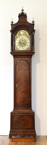
Furniture, James PEPPER, Mahogany cased grandfather clock, 1700s
... Benalla Art Gallery Benalla Art Gallery Benalla Botanical Gardens Bridge Street Benalla high-country Georgian Furniture Grandfather clock Clock Face Dial Mahogany Recto: "Tempus Fugir" engraved above clock face; "Tom. Pepper Beigelsnade" engraved on lower edge of clock face Polished mahogany-cased grandfather clock with intractely decorated gold face and chased silver and brass dial. ...Established: Biggleswade, Bedfordshire, England in 1720 by James Pepper IGeorgianLedger Bequest, 1993Polished mahogany-cased grandfather clock with intractely decorated gold face and chased silver and brass dial. Mounted on small wooden plinth.Recto: "Tempus Fugir" engraved above clock face; "Tom. Pepper Beigelsnade" engraved on lower edge of clock facefurniture, grandfather clock, clock, face, dial, mahogany -
 Hume City Civic Collection
Photograph
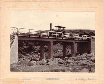
... Streets. The Gillies Bridge is situated on the Wildwood Road, just off the Lancefield Road. gillies bridge wildwood road sunbury bridges steam rollers bulldozers tractors christiansen chris photographers george evans collection Christiansen / Sunbury Studios A mounted sepia photograph of the Gillies Bridge at Sunbury. The mounting is cream with silver ...Chris. Christiansen had a barber shop in Sunbury and was the photographer in the town from 1895 until 1916. He conducted his business in a building situated on the corner of Evans and Brooks Streets. The Gillies Bridge is situated on the Wildwood Road, just off the Lancefield Road.A mounted sepia photograph of the Gillies Bridge at Sunbury. The mounting is cream with silver writing across the bottom of the photograph. There is a man driving a steam roller (traction engine) across the bridge and another man is standing at the bottom of the bridge on the RHS. The creek and rocks are in the foreground. Cream mounting - 2 cm wide with silver inscriptionsChristiansen / Sunbury Studiosgillies bridge, wildwood road, sunbury, bridges, steam rollers, bulldozers, tractors, christiansen, chris, photographers, george evans collection -
 Hume City Civic Collection
Photograph
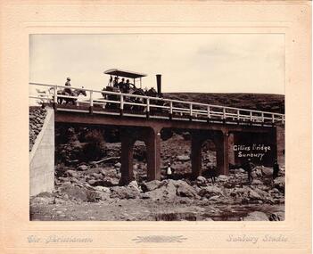
... Streets. The Gillies Bridge is Situated on the Wildwood Road just off the Lancefield Road. gillies bridge wildwood bridge bridges horses christiansen chris photographers animals steam rollers sunbury men clothing and dress george evans collection GILLIES BRIDGE / SUNBURY / CHR. CHRISTIANSEN / A mounted sepia photograph of the Gillies Bridge at Sunbury. Across the bridge there are three men on a steam roller and one man behind on horseback. There are four men standing across the creek bed. The mounting is cream, 2 cm wide with silver ...Chris. Christiansen was a barber in Sunbury. He also ran a photographic studio from 1892 - 1916. His business was situated on the corner of Evans and Brook Streets. The Gillies Bridge is Situated on the Wildwood Road just off the Lancefield Road.A mounted sepia photograph of the Gillies Bridge at Sunbury. Across the bridge there are three men on a steam roller and one man behind on horseback. There are four men standing across the creek bed. The mounting is cream, 2 cm wide with silver writing under the photo. Cream mounting - 2 cm wide with silver inscriptionsGILLIES BRIDGE / SUNBURY / CHR. CHRISTIANSEN /gillies bridge, wildwood bridge, bridges, horses, christiansen, chris, photographers, animals, steam rollers, sunbury, men, clothing and dress, george evans collection -
 Geelong Gallery
Photograph - Barwon River and Queen's Bridge, WASHBORNE, Thomas J, 1869-80
... Geelong Gallery 55 Little Malop Street Geelong geelong-and-the-bellarine-peninsula Albumen silver photograph Photograph Barwon River and Queen's Bridge WASHBORNE, Thomas J ...Albumen silver photograph -
 Horsham Regional Art Gallery
Photograph, Nicholas CAIRE, Giant tree bridge, Gippsland, n.d
... Horsham Regional Art Gallery 80 Wilson Street Horsham grampians silver albumen photograph on card Giant tree bridge, Gippsland Photograph Nicholas CAIRE ...Gift of Jeff and Jill Jenkinson, 2007silver albumen photograph on card -
 Horsham Regional Art Gallery
Photograph, Mark STRIZIC, From Princes Bridge, July, 1955 (printed 1998)
... Horsham Regional Art Gallery 80 Wilson Street Horsham grampians silver gelatin photograph From Princes Bridge, July Photograph Mark STRIZIC ...Donated through the Australian Government's Cultural Gifts Program by Dr Jonathan Hartley, 2006silver gelatin photograph -
 Horsham Regional Art Gallery
Photograph, Mark STRIZIC, From Swan Street Bridge - 1, 1958 (printed 1999)
... Horsham Regional Art Gallery 80 Wilson Street Horsham grampians silver gelatin photograph From Swan Street Bridge - 1 Photograph Mark STRIZIC ...Donated through the Australian Government's Cultural Gifts Program by Dr Jonathan Hartley, 2006silver gelatin photograph -
![Junction of the Rivers Yarra and Watt, Near Healesville / [by] Nicholas Caire, circa 1876](/media/collectors/550653872162f11fb04854aa/items/577740e5d0cdd10a5c0de011/item-media/57774153d0cdd10a5c0e0662/item-fit-380x285.jpg?cb=6) Kew Historical Society Inc
Kew Historical Society IncPhotograph, Anglo-Australasian Photographic Company, Junction of the Rivers Yarra and Watt, Near Healesville, c. 1876
... Bridge," at the junction, / is the name given to this crossing-place, which has been partly swept away by late floods. The depth of the Yarra here / is from 15 to 20 feet; that of the Watt, about 10 feet. printed in ink on support reverse l.c.l.: J.W. FORBES, Agent, printed in ink on support reverse l.c.: ANGLO-AUSTRALASIAN PHOTOGRAPHIC COMPANY, MELBOURNE. printed in ink on support reverse l.c.r.: 10 Temple Court, Collins Street West. Albumen Silver ...Nicholas Caire was born on Guernsey in the Channel Islands in 1837. He arrived in Adelaide with his parents in about 1860. In 1867, following photographic journeys in Gippsland, he opened a studio in Adelaide. From 1870 to 1876 he lived and worked in Talbot in Central Victoria. In 1876 he purchased T. F. Chuck's studios in the Royal Arcade Melbourne. In 1885, following the introduction of dry plate photography, he began a series of landscape series, which were commercially successful. As a photographer, he travelled extensively through Victoria, photographing places few of his contemporaries had previously seen. He died in 1918. Reference: Jack Cato, 'Caire, Nicholas John (1837–1918)', Australian Dictionary of Biography.An original, rare photograph from the series 'Views of Victoria: General Series' by the photographer, Nicholas Caire (1837-1918). The series of 60 photographs that comprise the series was issued c. 1876 and reinforced a neo-Romantic view of the Australian landscape to which a growing nationalist movement would respond. Nicholas Caire was active as a photographer in Australia from 1858 until his death in 1918. His vision of the Australian bush and pioneer life had a counterpart in the works of Henry Lawson and other nationalist poets, authors and painters.Albumen Silver Photograph, mounted on Board.printed in ink on support l.c.: JUNCTION OF THE RIVERS YARRA AND WATT, NEAR HEALESVILLE. / COPYRIGHT REGISTERED. printed in ink on support reverse c.: VIEWS OF VICTORIA. / (GENERAL SERIES.) / No. 3. / JUNCTION OF THE RIVERS YARRA AND WATT, NEAR HEALESVILLE / The junction is situated about 3 miles from Healesville, and 35 miles from the mouth of the Yarra. The souces / of the Watt are to be found at the head of the Black Spur, and, being fed by a number of creeks and springs, its / waters gain considerable force for several miles before joining those of the Yarra. The "Old Bridge," at the junction, / is the name given to this crossing-place, which has been partly swept away by late floods. The depth of the Yarra here / is from 15 to 20 feet; that of the Watt, about 10 feet. printed in ink on support reverse l.c.l.: J.W. FORBES, Agent, printed in ink on support reverse l.c.: ANGLO-AUSTRALASIAN PHOTOGRAPHIC COMPANY, MELBOURNE. printed in ink on support reverse l.c.r.: 10 Temple Court, Collins Street West.nicholas caire (1837-1918), yarra river, watt river, bridge, wooden bridge, healesville