Showing 44 items matching "site influences"
-
 Federation University Historical Collection
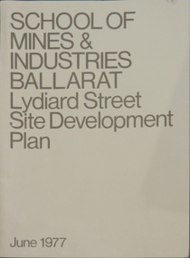
Book, School of Mines & Industries Ballarat Lydiard Streete Site Development Plan, 1977, 06/1977
... ...site influences...Barker Library (top floor) Mount Helen goldfields Ballarat School of Mines and industry is a predecessor of Federation University Australia. ballarat school of mines development plan site development lydiard street site influences campus plan Ballarat School of Mines Campus Brown soft covered book of the Lydiard Street Site Development Plan. ...Ballarat School of Mines and industry is a predecessor of Federation University Australia.Brown soft covered book of the Lydiard Street Site Development Plan.ballarat school of mines, development plan, site development, lydiard street, site influences, campus plan, ballarat school of mines campus -
 Kiewa Valley Historical Society
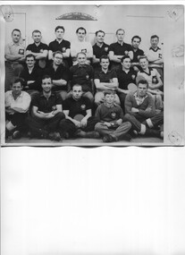
Photo - McKay Creek Table Tennis Club
... site of a power station where the employees lived in the camp while working there. Table tennis entertained them during their leisure time. This activity is of historic and social significance and can be compared with activities of today especially as Mt Beauty was built as a construction town for the Kiewa Hydro Electric Scheme and is now a small town with the added influence of tourism. ...During the construction of the Kiewa Hydro Electric Scheme the employees socialised by joining clubs such as the table tennis club.McKay Creek was the site of a power station where the employees lived in the camp while working there. Table tennis entertained them during their leisure time. This activity is of historic and social significance and can be compared with activities of today especially as Mt Beauty was built as a construction town for the Kiewa Hydro Electric Scheme and is now a small town with the added influence of tourism. McKay Creek was part of the construction with a work force living there.Large Black and white photo of the McKay Creek Table Tennis Club including 18 men and 1 boy.ID on the back and "AM Collection"mckay creek power station, table tennis club, kiewa hydro electric scheme -
 Eltham District Historical Society Inc
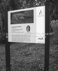
Photograph - Digital Photograph, Alan King, Sign: Clara Southern, Heidelberg School Artists Trail, Main Road, Research, 2008
... influenced by Cubism. This collection of almost 130 photos about places and people within the Shire of Nillumbik, an urban and rural municipality in Melbourne's north, contributes to an understanding of the history of the Shire. Published in 2008 immediately prior to the Black Saturday bushfires of February 7, 2009, it documents sites ...Warrandyte artist, Clara Southern, features on the Artists Trail. Published: Nillumbik Now and Then / Marguerite Marshall 2008; photographs Alan King with Marguerite Marshall.; p189 Since early in the 20th century this district has attracted artists and other creative people. So much so, that Eltham has been compared to the Left Bank in Paris, New York’s Greenwich Village and London’s Bloomsbury. That is until the 1970s when Eltham rapidly expanded into a suburb. However many artists still flourish not only in Montsalvat, Dunmoochin and the Bend of Islands but elsewhere in Nillumbik. Some artists who have worked or lived in Nillumbik are well-known nationally and internationally. Artists are attracted to the hilly district’s subtle colours, unique light and the Yarra River and Diamond Creek. The railway’s extension to Eltham in 1902 brought artists to paint for the day or to camp. Then many settled in Eltham, perhaps also because the poor quality land, far from the city, was cheap. Following World War Two they found they could build houses and studios cheaply by making their own mud-bricks. The flexible material, with its warm tones blending into the bush, also satisfied their aesthetic sensibilities. As early as 1900, Will Longstaff, known for his painting The Ghosts of Menin Gate at the National War Memorial in Canberra, lived at Stanhope in Peter Street, Eltham, later to become the home of intellectuals Clem and Nina Christensen. Members of Australia’s first significant art movement, the Heidelberg School of Artists, painted in Eltham, Warrandyte and Diamond Creek. Walter Withers lived at the corner of Bolton and Brougham Street, Eltham and taught Sir Hans Heysen, who for a short while stayed with the Withers family. In Warrandyte were Clara Southern, whom Frederick McCubbin taught at the National Gallery School and Penleigh Boyd, who is represented in all Australian state galleries and the National Collection in Canberra. May Vale, daughter of politician William, lived in Diamond Creek. With Jane Price they feature on the Heidelberg School Artists Trail, part of which runs through Nillumbik. The trail includes signs each displaying a reproduction of a painting by an artist and located near where the artist lived or painted. In Nillumbik the trail includes parts of Warrandyte, Eltham in the Alistair Knox Park, Main Road shopping precinct and Wingrove Park, the Research walking track on Main Road and the Diamond Creek Reserve. In 1916 artist William ‘Jock’ Frater lived at the corner of Arthur and Bible Streets, Eltham. Before then, Frater, with other artists including Percy Leason (who moved to Eltham in the mid 1920s) painted in Eltham on weekends. They camped near Bible and Pitt Streets and along the Diamond Creek where the Eltham Retirement Centre now stands.4 In 1921, painter Peter Newbury (father to painter David Newbury, who was born in Eltham) moved to Cromwell Street, Eltham. Max Meldrum, the first Australian painter to formulate a consistent theory of art largely based on tone,5 taught local artists Alan Martin, Clarice Beckett, Peter Glass and Justus Jörgensen. Meldrum visited Eltham then rented a house there for 18 months opposite Wingrove Park. In 1934, artist and architect Justus Jörgensen and his doctor wife Lil and friends built Montsalvat, the artists’ colony. Montsalvat has played an important part in attracting artists to Eltham and its mud-brick, pisé, stone and recycled building materials has had a major influence on Eltham’s built environment. Jörgensen’s students who also helped him build Monstalvat included Arthur Munday, Lesley Sinclair, Helen Lempriere, Joe Hannan, Helen, Sonia and jeweller/sculptor, Matcham Skipper. Among artists who visited Montsalvat were Clifton Pugh and Angry Penguins’ artists Albert Tucker and Arthur Boyd. Some who painted after World War Two were Alan Martin of Eltham and Warrandyte artists Frank Crozier and Harry De Hartog6, one of Melbourne’s first painters influenced by Cubism.This collection of almost 130 photos about places and people within the Shire of Nillumbik, an urban and rural municipality in Melbourne's north, contributes to an understanding of the history of the Shire. Published in 2008 immediately prior to the Black Saturday bushfires of February 7, 2009, it documents sites that were impacted, and in some cases destroyed by the fires. It includes photographs taken especially for the publication, creating a unique time capsule representing the Shire in the early 21st century. It remains the most recent comprehenesive publication devoted to the Shire's history connecting local residents to the past. nillumbik now and then (marshall-king) collection, clara southern, main road, research (vic), heidelberg school artists trail -
 Eltham District Historical Society Inc
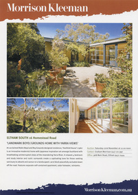
Document - Property Binder, 16 Homestead Road, Eltham, 'Handfield House'
... They were still the owners when the house was included in the 1992 Shire of Eltham Heritage Study The 1992 Study advised: CULTURAL SIGNIFICANCE Designed by well-known Victorian Architect Robin Boyd after he returned from lecturing architectural students in Japan, the Handfield residence shows the influence of traditional Japanese design in its modular wall arrangements, solid and glazed panels and sliding exterior doors. The courtyard planning, floor to ceiling glass walls and the combination of single and double storey sections on the steep site illustrate quite advanced dwelling design for its time. ...They were still the owners when the house was included in the 1992 Shire of Eltham Heritage Study The 1992 Study advised: CULTURAL SIGNIFICANCE Designed by well-known Victorian Architect Robin Boyd after he returned from lecturing architectural students in Japan, the Handfield residence shows the influence of traditional Japanese design in its modular wall arrangements, solid and glazed panels and sliding exterior doors. The courtyard planning, floor to ceiling glass walls and the combination of single and double storey sections on the steep site illustrate quite advanced dwelling design for its time. ...Contents: 1. Morrison Kleeman Sales brochure 2008 2. Newsclipping; Advertisement, Morrison Kleeman, Eltham South 16 Homestead Road, Diamond Valley Leader, November 5, 2008, p7 (on reverse, p8 Advertisement, Morrison Kleeman, Eltham 45 Lavender Park Road) Designed by Robin Boyd for friends John and Esta Handfield, Handfield House was built 1961. In a letter dated 16 May 1989 to Blanche Shallard of the Shire of Eltham Historical Society, John Handfield advised that the house was designed by their friend Robin Boyd and that it was built in 1961. As of that date they had been the only occupants. They were still the owners when the house was included in the 1992 Shire of Eltham Heritage Study The 1992 Study advised: CULTURAL SIGNIFICANCE Designed by well-known Victorian Architect Robin Boyd after he returned from lecturing architectural students in Japan, the Handfield residence shows the influence of traditional Japanese design in its modular wall arrangements, solid and glazed panels and sliding exterior doors. The courtyard planning, floor to ceiling glass walls and the combination of single and double storey sections on the steep site illustrate quite advanced dwelling design for its time. Designed to house three generations, grandparents, their children and grandchildren, the house at the time of the 1992 study was reported to be very intact. DESCRIPTION Quite advanced design, in planning and detailing. Plan U-shaped. Single and double storied; the arms of the U are basically single storied, while the base running parallel with the Yarra River is two storied. Walls timber stud framed?, asbestos cement sheet clad. Roofs flat?. Floors timber, some concrete?. Features include the modular wall design, courtyard planning, combination of single and double storey sections, internal planning and floor to ceiling glass walls. SOURCES OF INFORMATION: Information from Mr. John Handfield. CONSERVATION GUIDELINES: Keep this residence intact. Esta Handfield died in 1995 The property was sold in 1996 Property history (source realestate.com.au) 2022 – Sold $2,240,000 September 17, 2022 by Jellis Craig - Eltham 1998 – Sold $348,500 June 20, 1998 1996 – Sold $250,000 September 9, 1996 (possibly Stockdale & Leggo) The property was offered for sale in 2008 by Morrison Kleeman with a price guide of $900,00 to $990,00 but it has not been confirmed if this sale proceeded property, eltham, houses, john handfield, esta handfield, robin boyd, 16 homestead road, handfield house, 45 lavender park road -
 Eltham District Historical Society Inc
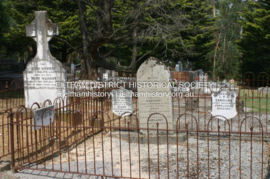
Photograph - Digital Photograph, Alan King, Graves of Thomas Sweeney and family, Eltham Cemetery, Victoria, 27 January 2008
... influence on the literary development of post World War Two Australia. Others were: composer Dorian Le Gallienne; artist Peter Glass; Stephen Dattner, a prominent Melbourne furrier; ALP parliamentarian for Greensborough, Pauline Toner and political scientist and commentator, Professor William Macmahon Ball. This collection of almost 130 photos about places and people within the Shire of Nillumbik, an urban and rural municipality in Melbourne's north, contributes to an understanding of the history of the Shire. Published in 2008 immediately prior to the Black Saturday bushfires of February 7, 2009, it documents sites ...The grave of Thomas Sweeney, former convict turned respectable citizen. The Murray and Sweeney families were both early settlers of the Eltham district and connected by marriage. Their family plots are located side by side in the Catholic section of the Eltham Cemetery. Irish-born Thomas Sweeney is regarded as the first settler in Eltham. He was transported to Sydney in 1823 after being convicted of arson. He was granted his freedom in 1838 and married Margaret Meehan in the same year. They moved to Melbourne and in 1842 Thomas purchased 110 acres beside the Yarra River in the vicinity of present-day Sweeneys Lane. He called the property ‘Culla Hill’ and built a small slab hut (reputedly with Wurundjeri help; Margaret is said to have run an informal hospital for them in return). This was followed in 1846 by more substantial buildings consisting of a three-roomed Irish-style ‘longhouse’ and a barn made of stone and handmade bricks, with doors large enough to accommodate a fully loaded wagon. When the gold rush came, Thomas prospered by selling meat and potatoes to the prospectors, enabling him to purchase a further 308 acres in 1856. He promoted the construction of a bridge over the Plenty River and the establishment of a school at Eltham. Roman Catholic Church services were held at Culla Hill in the early years. When he died in 1867, he was regarded as a respected member of the community. Thomas and Margaret are buried in Eltham Cemetery with many of their descendants. Their first son John continued to farm Culla Hill until his death in 1909. Culla Hill passed out of the Sweeneys' possession in 1939. The house and barn remain today, though lesser outbuildings have gone. The facade of the house is much the same as it was in the 1840s. Sacred To the memory of Thomas Sweeney Who died Sep 6th 1867 Aged 65 years May his soul res in peace Also his wife Margaret Died Oct 3rd 1884 aged 73 years And their daughters Annie Died Aug 22nd 1860 aged 21 years Johanna Died Aug 19th 1872 aged 22 years Margaret Died 7th Sep 1913 aged 72 years R.I.P. Also In Memory Of John Sweeney Died 24th May 1909 Aged 65 years Also of his wife Ellen Died 8th March 1910 Aged 64 years R.I.P Also In Memory Of Caroline Infant daughter of John & Ellen Sweeney Published: Nillumbik Now and Then / Marguerite Marshall 2008; photographs Alan King with Marguerite Marshall.; p55 From the piety and poverty of 19th century Eltham, 20th century artists and environmentalists, to today’s comfortable middle class, Eltham Cemetery records it all — and more. A visit to Eltham Cemetery reveals an important social record since its beginnings in 1858. The cemetery was situated on about six acres (2.4ha) (now around 4.8ha) at the corner of Mount Pleasant and Metery Roads.1* It is thought that Metery Road was originally called Cemetery Road, but in the early 1940s, a resident, possibly a councillor, objected to the name resulting in the change.2 Much can be gleaned about the developing Eltham community from burial styles and the names of former local residents. Originally the cemetery was divided into Christian denominations, like others of that time, following the United Kingdom burial system. In 1861 the cemetery included Church of England, Presbyterian, Roman Catholic and Wesleyans (later Methodist) sites. Graves also indicated social class. Some had grand tombstones, perhaps fenced with ornamental cast iron railing, but most in the 1860s and 1870s were constructed of modest stone slabs.3 This indicated the poverty of the district, which was largely inhabited by farmers on small landholdings. A poignant reminder of the high rates of infant mortality of those times, are the many infants and young children recorded on the headstones. Major changes occurred in the cemetery in the late 20th century as Christian adherence weakened and society became more egalitarian and informal. In the early 1970s a non-denominational lawn section for burials was established. Since then all new areas have been non-denominational to accommodate the more diverse local community. Now, instead of large ornamental headstones, some mourners have chosen boulders, reflecting the natural Eltham style, while others choose graves in the lawn areas or niches in walls. In the late 1970s, the University Donor Section was established north-west of Candlebark Lawn for those who donated their bodies for The University of Melbourne medical research. In the early 1980s the natural Australian garden style, popular in Eltham, was mirrored in a new section called Ashes Walk. Local landscape architect Gordon Ford, who had popularised this style, designed the Walk using boulders shaded by native plants beside curved pathways. Landscape architect Robert Boyle later redesigned Ashes Walk and developed other parts of the cemetery in keeping with this style.4 Appropriately Ford, who died in 1999, was interred in the Native Garden Section in a cluster of sites shaded by a large eucalyptus tree.5 By 2007, about 6400 interments were recorded in the Eltham Cemetery. Close inspection reveals notable names in the district’s history. The grave of Thomas Sweeney, a former convict who became a respected citizen, can be found in the Roman Catholic section near the path. Eltham Primary School’s first headmaster, David Clark, is buried in a modest grave in the Church of England section to the east of the path from the main entrance. Sir William Irvine, Victorian Premier from 1900 to 1902, whose grave is in the north-east Presbyterian section was at various times Victoria’s Chief Justice, Deputy Governor and Treasurer.6 Further south is the grave of social reformer Bertram Wainer, born in Scotland in 1928 and died in 1987. He campaigned to legalise abortion and exposed police corruption in allowing illegal ‘backyard’ abortions. Other prominent local residents interred in the cemetery include: Justus Jörgensen, who founded Montsalvat; Alistair Knox, the mud-brick housing pioneer and Eltham Shire Councillor from 1971 to 1975 and President in 1975; Clem and Nina Christensen, who had a major influence on the literary development of post World War Two Australia. Others were: composer Dorian Le Gallienne; artist Peter Glass; Stephen Dattner, a prominent Melbourne furrier; ALP parliamentarian for Greensborough, Pauline Toner and political scientist and commentator, Professor William Macmahon Ball.This collection of almost 130 photos about places and people within the Shire of Nillumbik, an urban and rural municipality in Melbourne's north, contributes to an understanding of the history of the Shire. Published in 2008 immediately prior to the Black Saturday bushfires of February 7, 2009, it documents sites that were impacted, and in some cases destroyed by the fires. It includes photographs taken especially for the publication, creating a unique time capsule representing the Shire in the early 21st century. It remains the most recent comprehenesive publication devoted to the Shire's history connecting local residents to the past. nillumbik now and then (marshall-king) collection, annie sweeney, caroline sweeney, ellen sweeney, eltham cemetery, graves, gravestones, johanna sweeney, john murray, john sweeney, margaret sweeney, mary ellen drain, mary murray, thomas murray, thomas sweeney -
 Glen Eira Historical Society
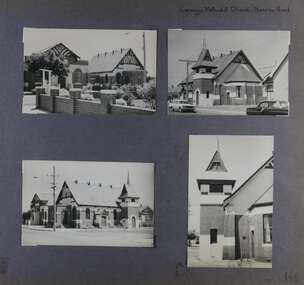
Album - Album page, Carnegie Methodist Church, Neerim Road, Circa 1972
... influenced character of the main church and hall. Its historical value rests in the early date of the original building and the manner in which the remaining buildings are representative of the principal period of settlement of the locality. The social significance derives from the use of the site ...This photograph is part of the Caulfield Historical Album 1972. This album was created in approximately 1972 as part of a project by the Caulfield Historical Society to assist in identifying buildings worthy of preservation. The album is related to a Survey the Caulfield Historical Society developed in collaboration with the National Trust of Australia (Victoria) and Caulfield City Council to identify historic buildings within the City of Caulfield that warranted the protection of a National Trust Classification. Principal photographer thought to be Trevor Hart, member of Caulfield Historical Society. Most photographs were taken between 1966-1972 with a small number of photographs being older and from unknown sources. All photographs are black and white except where stated, with 386 photographs over 198 pages. From Victorian Heritage Database citation for HO47 Uniting Church, 254 Neerim Road https://vhd.heritagecouncil.vic.gov.au/places/42432 (as at 28/10/2020) The former Methodist church (now Uniting church) complex at 252-54 Neerim Road, Carnegie, consists of the original timber church of 1886, the present brick Arts and Crafts influenced church of 1914, designed by A. Phipps Coles, the timber hall attached to the original church, built during the interwar period and the present brick hall of 1933, designed by J.F. Snell. From Victorian Heritage Database citation for HO47 Uniting Church, 254 Neerim Road https://vhd.heritagecouncil.vic.gov.au/places/42432 (as at 28/10/2020) The complex has aesthetic, historical and social significance. Its aesthetic value is derived from the extreme simplicity of the original church and the highly picturesque, eclectic, Arts and Crafts influenced character of the main church and hall. Its historical value rests in the early date of the original building and the manner in which the remaining buildings are representative of the principal period of settlement of the locality. The social significance derives from the use of the site as a place of worship since the commencement of the closer settlement of Carnegie from as early as 1886. Page 146 of Photograph Album with four photographs (3 landscape, 1 portrait) of Carnegie Methodist Church, Neerim Road.Handwritten: Carnegie Methodist Church Neerim Road [top right] / 146 [bottom right]trevor hart, neerim road, carnegie methodist church, church, toolambool road, wesleyan methodist church, breslin gallery, anthony breslin, 1910's, american romanesque, spire, half gabled tower, art, gallery, cafe, arched doorways, red brick, uniting church, carnegie, arts and craft style, a p coles, a coles, j f snell, j snell, halls -
 Glen Eira Historical Society
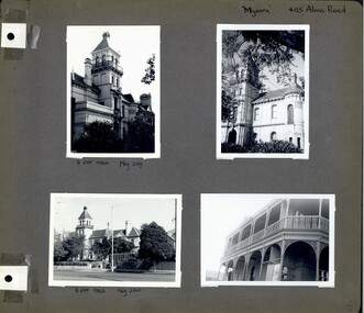
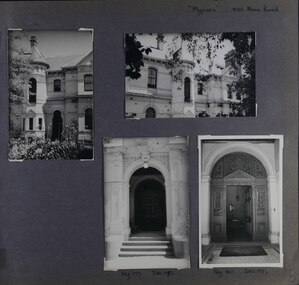
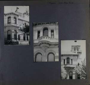
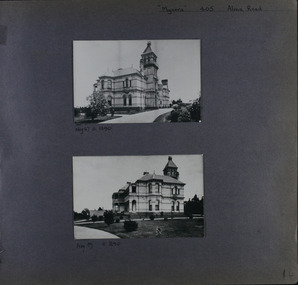
Album - Album page, Myoora, 405 Alma Road, Circa 1972
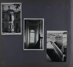
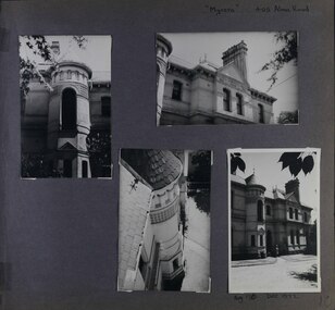
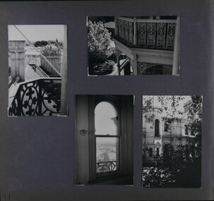
... The siting of Myoora on a ridge influenced its planning and composition. ...This photograph is part of the Caulfield Historical Album 1972. This album was created in approximately 1972 as part of a project by the Caulfield Historical Society to assist in identifying buildings worthy of preservation. The album is related to a Survey the Caulfield Historical Society developed in collaboration with the National Trust of Australia (Victoria) and Caulfield City Council to identify historic buildings within the City of Caulfield that warranted the protection of a National Trust Classification. Principal photographer thought to be Trevor Hart, member of Caulfield Historical Society. Most photographs were taken between 1966-1972 with a small number of photographs being older and from unknown sources. All photographs are black and white except where stated, with 386 photographs over 198 pages. Myoora - Victorian Heritage Register (VHR) Number H0490 https://vhd.heritagecouncil.vic.gov.au/places/275 Myoora, 405 Alma Road, North Caulfield, was designed by Reed, Henderson & Smart and can be attributed to Anketell Henderson. It was built in 1886 and 1887 for Thomas Christian, who had founded the fabled gold mine, the Day Dawn at Charters Towers. He never occupied the house although his widow lived there for some time. The house was subdivided into three and later six flats. Myoora was one of many large mansions on broad acres with gardens in Caulfield. Perhaps the grandest was Labassa. The mansions date from the 1850s through to the late 1890s. The siting of Myoora on a ridge influenced its planning and composition. A central hall and corridor along the ridge is entered from the centre of the more formal north facade. The entrance is marked by an elaborately detailed tower. A stair turret provides a second accent. The western end of the building is completed by a massively detailed chimney as the service wing. The south facade enjoyed an outlook to port phillip from a two-storey cast iron verandah. Bay windows, chimneys, the tower and the turret and minor details are brought together in a sophisticated asymmetrical composition. This is reflected in the planning. The asymmetry of Myoora pivoting on the tower is the most notable feature of the building. The walls are built of cement rendered brick. The cement render has not been painted. The roof is slate. The balconies and verandah are cast iron. The footings and cellar are bluestone. The architectural firm Reed, Henderson & Smart was very prominent in Victoria in the nineteenth century. Anketell Henderson was an eminent and well respected member of the profession. He worked successfully in London and interstate as well as in Victoria. They were better known for commercial and public buildings. Myoora is an important private commission. The style of Myoora is a combination of details from the Continental and English Renaissance through the boom style and the Queen Anne style. There is also an early influence from the American Romanesque style especially in the stair turret. The latter style was important at the turn of the century and Myoora is a significant precursor. Other buildings of a similar scale survive in Caulfield and elsewhere. Labassa, the most fabulous, is quite different stylistically as are most of the other comparable mansions.Page 6 of Photograph Album including four black and white photographs of the mansion Myoora. Two photographs in the top half of the page are in portrait orientation while the two photographs in the bottom half of the page are in landscape orientation.Handwritten: "Myoora" 405 Alma Rd [top right hand corner] / 8 Oct 1966 Neg 229 [underneath top left photograph] / 8 Oct 1966 Neg 230 [underneath bottom left photograph] / 6 [bottom right]caulfield north, trevor hart, alma road, mansion, myoora, tower, lacework, arched windows, anketell henderson, thomas christian, 1880's, cement rendered brick, slate roof, cast iron verandah, cast iron balconies, bluestone footings, queen anne, american romanesque, bay windows, boom style, continental and english renaissance, cast iron work, reed henderson & smart, flats, gardens, asymmetrical style -
 Glen Eira Historical Society
Album - Album page, Myoora, 405 Alma Road, Circa 1972
... The siting of Myoora on a ridge influenced its planning and composition. ...This photograph is part of the Caulfield Historical Album 1972. This album was created in approximately 1972 as part of a project by the Caulfield Historical Society to assist in identifying buildings worthy of preservation. The album is related to a Survey the Caulfield Historical Society developed in collaboration with the National Trust of Australia (Victoria) and Caulfield City Council to identify historic buildings within the City of Caulfield that warranted the protection of a National Trust Classification. Principal photographer thought to be Trevor Hart, member of Caulfield Historical Society. Most photographs were taken between 1966-1972 with a small number of photographs being older and from unknown sources. All photographs are black and white except where stated, with 386 photographs over 198 pages. Myoora - Victorian Heritage Register (VHR) Number H0490 https://vhd.heritagecouncil.vic.gov.au/places/275 Myoora, 405 Alma Road, North Caulfield, was designed by Reed, Henderson & Smart and can be attributed to Anketell Henderson. It was built in 1886 and 1887 for Thomas Christian, who had founded the fabled gold mine, the Day Dawn at Charters Towers. He never occupied the house although his widow lived there for some time. The house was subdivided into three and later six flats. Myoora was one of many large mansions on broad acres with gardens in Caulfield. Perhaps the grandest was Labassa. The mansions date from the 1850s through to the late 1890s. The siting of Myoora on a ridge influenced its planning and composition. A central hall and corridor along the ridge is entered from the centre of the more formal north facade. The entrance is marked by an elaborately detailed tower. A stair turret provides a second accent. The western end of the building is completed by a massively detailed chimney as the service wing. The south facade enjoyed an outlook to port phillip from a two-storey cast iron verandah. Bay windows, chimneys, the tower and the turret and minor details are brought together in a sophisticated asymmetrical composition. This is reflected in the planning. The asymmetry of Myoora pivoting on the tower is the most notable feature of the building. The walls are built of cement rendered brick. The cement render has not been painted. The roof is slate. The balconies and verandah are cast iron. The footings and cellar are bluestone. The architectural firm Reed, Henderson & Smart was very prominent in Victoria in the nineteenth century. Anketell Henderson was an eminent and well respected member of the profession. He worked successfully in London and interstate as well as in Victoria. They were better known for commercial and public buildings. Myoora is an important private commission. The style of Myoora is a combination of details from the Continental and English Renaissance through the boom style and the Queen Anne style. There is also an early influence from the American Romanesque style especially in the stair turret. The latter style was important at the turn of the century and Myoora is a significant precursor. Other buildings of a similar scale survive in Caulfield and elsewhere. Labassa, the most fabulous, is quite different stylistically as are most of the other comparable mansions.Page 7 of Photograph Album including four black and white photographs. Three photos are in a portrait orientation and placed diagonally across the page from the top left hand side to the bottom right hand side. One photograph in a landscape orientation is on the top right hand side of the page. Handwritten: 007 (bottom left hand corner)caulfield north, trevor hart, alma road, mansion, myoora, tower, thomas christian, 1880's, queen anne, cement rendered brick, unpainted, balconies, verandahs, anketell henderson, continental and english renaissance, american romanesque, views, cast iron work, reed henderson & smart, flats, gardens, asymmetrical style, slate roofs -
 Glen Eira Historical Society
Album - Album page, Myoora, 405 Alma Road, Circa 1972
... The siting of Myoora on a ridge influenced its planning and composition. ...This photograph is part of the Caulfield Historical Album 1972. This album was created in approximately 1972 as part of a project by the Caulfield Historical Society to assist in identifying buildings worthy of preservation. The album is related to a Survey the Caulfield Historical Society developed in collaboration with the National Trust of Australia (Victoria) and Caulfield City Council to identify historic buildings within the City of Caulfield that warranted the protection of a National Trust Classification. Principal photographer thought to be Trevor Hart, member of Caulfield Historical Society. Most photographs were taken between 1966-1972 with a small number of photographs being older and from unknown sources. All photographs are black and white except where stated, with 386 photographs over 198 pages.Myoora - Victorian Heritage Register (VHR) Number H0490 https://vhd.heritagecouncil.vic.gov.au/places/275 (as at 6/10/2020) Myoora, 405 Alma Road, North Caulfield, was designed by Reed, Henderson & Smart and can be attributed to Anketell Henderson. It was built in 1886 and 1887 for Thomas Christian, who had founded the fabled gold mine, the Day Dawn at Charters Towers. He never occupied the house although his widow lived there for some time. The house was subdivided into three and later six flats. Myoora was one of many large mansions on broad acres with gardens in Caulfield. Perhaps the grandest was Labassa. The mansions date from the 1850s through to the late 1890s. The siting of Myoora on a ridge influenced its planning and composition. A central hall and corridor along the ridge is entered from the centre of the more formal north facade. The entrance is marked by an elaborately detailed tower. A stair turret provides a second accent. The western end of the building is completed by a massively detailed chimney as the service wing. The south facade enjoyed an outlook to port phillip from a two-storey cast iron verandah. Bay windows, chimneys, the tower and the turret and minor details are brought together in a sophisticated asymmetrical composition. This is reflected in the planning. The asymmetry of Myoora pivoting on the tower is the most notable feature of the building. The walls are built of cement rendered brick. The cement render has not been painted. The roof is slate. The balconies and verandah are cast iron. The footings and cellar are bluestone. The architectural firm Reed, Henderson & Smart was very prominent in Victoria in the nineteenth century. Anketell Henderson was an eminent and well respected member of the profession. He worked successfully in London and interstate as well as in Victoria. They were better known for commercial and public buildings. Myoora is an important private commission. The style of Myoora is a combination of details from the Continental and English Renaissance through the boom style and the Queen Anne style. There is also an early influence from the American Romanesque style especially in the stair turret. The latter style was important at the turn of the century and Myoora is a significant precursor. Other buildings of a similar scale survive in Caulfield and elsewhere. Labassa, the most fabulous, is quite different stylistically as are most of the other comparable mansions. Stonnington is perhaps closer but relies on different details from the Queen Anne style and lacks any American influence. For its historical associations through its owners and architects, for its style and composition and for its intactness, Myoora is significant at a State level. The craftmanship of Myoora is what could be expected of a building of the time and type. It is relatively intact and in fair condition. The main staircase has been removed, minor alterations to decorative features have occurred and additions have been made to the exterior.Page 8 of Photograph Album including four black and white photographs. Three photos are in a portrait orientation, one on the left hand side of the page with the other two in the bottom part of the page. One photograph in a landscape orientation is on the top right hand side of the page. Handwritten: "Myoora" 405 Alma Rd [top right hand corner] / Neg 179 DEC 1972 [underneath bottom left photograph] / Neg 180 DEC 1972 [underneath bottom right photograph] / 8 [bottom right]caulfield north, trevor hart, alma road, mansion, myoora, tower, thomas christian, 1880's, queen anne, cement rendered brick, unpainted, balconies, verandahs, anketell henderson, continental and english renaissance, american romanesque, views, cast iron work, reed henderson & smart, flats, gardens, asymmetrical style, slate roofs, entrances -
 Glen Eira Historical Society
Album - Album page, Myoora, 405 Alma Road, Circa 1972
... The siting of Myoora on a ridge influenced its planning and composition. ...This photograph is part of the Caulfield Historical Album 1972. This album was created in approximately 1972 as part of a project by the Caulfield Historical Society to assist in identifying buildings worthy of preservation. The album is related to a Survey the Caulfield Historical Society developed in collaboration with the National Trust of Australia (Victoria) and Caulfield City Council to identify historic buildings within the City of Caulfield that warranted the protection of a National Trust Classification. Principal photographer thought to be Trevor Hart, member of Caulfield Historical Society. Most photographs were taken between 1966-1972 with a small number of photographs being older and from unknown sources. All photographs are black and white except where stated, with 386 photographs over 198 pages.Myoora - Victorian Heritage Register (VHR) Number H0490 From the Victorian Heritage Register Database - Citation for Myoora https://vhd.heritagecouncil.vic.gov.au/places/275 (as at 6/10/2020) Myoora, 405 Alma Road, North Caulfield, was designed by Reed, Henderson & Smart and can be attributed to Anketell Henderson. It was built in 1886 and 1887 for Thomas Christian, who had founded the fabled gold mine, the Day Dawn at Charters Towers. He never occupied the house although his widow lived there for some time. The house was subdivided into three and later six flats. Myoora was one of many large mansions on broad acres with gardens in Caulfield. Perhaps the grandest was Labassa. The mansions date from the 1850s through to the late 1890s. The siting of Myoora on a ridge influenced its planning and composition. A central hall and corridor along the ridge is entered from the centre of the more formal north facade. The entrance is marked by an elaborately detailed tower. A stair turret provides a second accent. The western end of the building is completed by a massively detailed chimney as the service wing. The south facade enjoyed an outlook to port phillip from a two-storey cast iron verandah. Bay windows, chimneys, the tower and the turret and minor details are brought together in a sophisticated asymmetrical composition. This is reflected in the planning. The asymmetry of Myoora pivoting on the tower is the most notable feature of the building. The walls are built of cement rendered brick. The cement render has not been painted. The roof is slate. The balconies and verandah are cast iron. The footings and cellar are bluestone. The architectural firm Reed, Henderson & Smart was very prominent in Victoria in the nineteenth century. Anketell Henderson was an eminent and well respected member of the profession. He worked successfully in London and interstate as well as in Victoria. They were better known for commercial and public buildings. Myoora is an important private commission. The style of Myoora is a combination of details from the Continental and English Renaissance through the boom style and the Queen Anne style. There is also an early influence from the American Romanesque style especially in the stair turret. The latter style was important at the turn of the century and Myoora is a significant precursor. Other buildings of a similar scale survive in Caulfield and elsewhere. Labassa, the most fabulous, is quite different stylistically as are most of the other comparable mansions. Stonnington is perhaps closer but relies on different details from the Queen Anne style and lacks any American influence. For its historical associations through its owners and architects, for its style and composition and for its intactness, Myoora is significant at a State level. The craftmanship of Myoora is what could be expected of a building of the time and type. It is relatively intact and in fair condition. The main staircase has been removed, minor alterations to decorative features have occurred and additions have been made to the exterior.Page 9 of Photograph Album including three black and white photographs. The photos are in a portrait orientation and arranged diagonally across the page from top left to bottom right.Handwritten: Neg 175 DEC 1972 [underneath top left photograph] / Neg 173 DEC 1972 [underneath middle photograph] / 9 [bottom left]caulfield north, trevor hart, alma road, mansion, myoora, tower, thomas christian, 1880's, queen anne, cement rendered brick, unpainted, balconies, verandahs, anketell henderson, continental and english renaissance, american romanesque, views, cast iron work, reed henderson & smart, flats, asymmetrical style, slate roofs, windows -
 Glen Eira Historical Society
Album - Album page, Myoora, 405 Alma Road, Circa 1972
... The siting of Myoora on a ridge influenced its planning and composition. ...This photograph is part of the Caulfield Historical Album 1972. This album was created in approximately 1972 as part of a project by the Caulfield Historical Society to assist in identifying buildings worthy of preservation. The album is related to a Survey the Caulfield Historical Society developed in collaboration with the National Trust of Australia (Victoria) and Caulfield City Council to identify historic buildings within the City of Caulfield that warranted the protection of a National Trust Classification. Principal photographer thought to be Trevor Hart, member of Caulfield Historical Society. Most photographs were taken between 1966-1972 with a small number of photographs being older and from unknown sources. All photographs are black and white except where stated, with 386 photographs over 198 pages.Myoora - Victorian Heritage Register (VHR) Number H0490 Citation for Myoora https://vhd.heritagecouncil.vic.gov.au/places/275 (as at 6/10/2020) Myoora, 405 Alma Road, North Caulfield, was designed by Reed, Henderson & Smart and can be attributed to Anketell Henderson. It was built in 1886 and 1887 for Thomas Christian, who had founded the fabled gold mine, the Day Dawn at Charters Towers. He never occupied the house although his widow lived there for some time. The house was subdivided into three and later six flats. Myoora was one of many large mansions on broad acres with gardens in Caulfield. Perhaps the grandest was Labassa. The mansions date from the 1850s through to the late 1890s. The siting of Myoora on a ridge influenced its planning and composition. A central hall and corridor along the ridge is entered from the centre of the more formal north facade. The entrance is marked by an elaborately detailed tower. A stair turret provides a second accent. The western end of the building is completed by a massively detailed chimney as the service wing. The south facade enjoyed an outlook to port phillip from a two-storey cast iron verandah. Bay windows, chimneys, the tower and the turret and minor details are brought together in a sophisticated asymmetrical composition. This is reflected in the planning. The asymmetry of Myoora pivoting on the tower is the most notable feature of the building. The walls are built of cement rendered brick. The cement render has not been painted. The roof is slate. The balconies and verandah are cast iron. The footings and cellar are bluestone. The architectural firm Reed, Henderson & Smart was very prominent in Victoria in the nineteenth century. Anketell Henderson was an eminent and well respected member of the profession. He worked successfully in London and interstate as well as in Victoria. They were better known for commercial and public buildings. Myoora is an important private commission. The style of Myoora is a combination of details from the Continental and English Renaissance through the boom style and the Queen Anne style. There is also an early influence from the American Romanesque style especially in the stair turret. The latter style was important at the turn of the century and Myoora is a significant precursor. Other buildings of a similar scale survive in Caulfield and elsewhere. Labassa, the most fabulous, is quite different stylistically as are most of the other comparable mansions. Stonnington is perhaps closer but relies on different details from the Queen Anne style and lacks any American influence. For its historical associations through its owners and architects, for its style and composition and for its intactness, Myoora is significant at a State level. The craftmanship of Myoora is what could be expected of a building of the time and type. It is relatively intact and in fair condition. The main staircase has been removed, minor alterations to decorative features have occurred and additions have been made to the exterior.Page 10 of Photograph Album including four black and white photographs. Three photos are in a portrait orientation with the fourth on the right in a landscape orientation.Handwritten: "Myoora" 405 Alma Rd [top right of page] / Neg 176 DEC 1972 [underneath bottom right photograph] / 10 [bottom right]caulfield north, trevor hart, alma road, mansion, myoora, tower, thomas christian, 1880's, queen anne, cement rendered brick, unpainted, balconies, verandahs, anketell henderson, continental and english renaissance, american romanesque, cast iron work, reed henderson & smart, flats, gardens, asymmetrical style, slate roofs, chimneys -
 Glen Eira Historical Society
Album - Album page, Myoora, 405 Alma Road, Circa 1972
... The siting of Myoora on a ridge influenced its planning and composition. ...This photograph is part of the Caulfield Historical Album 1972. This album was created in approximately 1972 as part of a project by the Caulfield Historical Society to assist in identifying buildings worthy of preservation. The album is related to a Survey the Caulfield Historical Society developed in collaboration with the National Trust of Australia (Victoria) and Caulfield City Council to identify historic buildings within the City of Caulfield that warranted the protection of a National Trust Classification. Principal photographer thought to be Trevor Hart, member of Caulfield Historical Society. Most photographs were taken between 1966-1972 with a small number of photographs being older and from unknown sources. All photographs are black and white except where stated, with 386 photographs over 198 pages.Victorian Heritage Register (VHR) Number H0490 From the Victorian Heritage Register Database - Citation for Myoora https://vhd.heritagecouncil.vic.gov.au/places/275 (as at 6/10/2020) Myoora, 405 Alma Road, North Caulfield, was designed by Reed, Henderson & Smart and can be attributed to Anketell Henderson. It was built in 1886 and 1887 for Thomas Christian, who had founded the fabled gold mine, the Day Dawn at Charters Towers. He never occupied the house although his widow lived there for some time. The house was subdivided into three and later six flats. Myoora was one of many large mansions on broad acres with gardens in Caulfield. Perhaps the grandest was Labassa. The mansions date from the 1850s through to the late 1890s. The siting of Myoora on a ridge influenced its planning and composition. A central hall and corridor along the ridge is entered from the centre of the more formal north facade. The entrance is marked by an elaborately detailed tower. A stair turret provides a second accent. The western end of the building is completed by a massively detailed chimney as the service wing. The south facade enjoyed an outlook to port phillip from a two-storey cast iron verandah. Bay windows, chimneys, the tower and the turret and minor details are brought together in a sophisticated asymmetrical composition. This is reflected in the planning. The asymmetry of Myoora pivoting on the tower is the most notable feature of the building. The walls are built of cement rendered brick. The cement render has not been painted. The roof is slate. The balconies and verandah are cast iron. The footings and cellar are bluestone. The architectural firm Reed, Henderson & Smart was very prominent in Victoria in the nineteenth century. Anketell Henderson was an eminent and well respected member of the profession. He worked successfully in London and interstate as well as in Victoria. They were better known for commercial and public buildings. Myoora is an important private commission. The style of Myoora is a combination of details from the Continental and English Renaissance through the boom style and the Queen Anne style. There is also an early influence from the American Romanesque style especially in the stair turret. The latter style was important at the turn of the century and Myoora is a significant precursor. Other buildings of a similar scale survive in Caulfield and elsewhere. Labassa, the most fabulous, is quite different stylistically as are most of the other comparable mansions. Stonnington is perhaps closer but relies on different details from the Queen Anne style and lacks any American influence. For its historical associations through its owners and architects, for its style and composition and for its intactness, Myoora is significant at a State level. The craftmanship of Myoora is what could be expected of a building of the time and type. It is relatively intact and in fair condition. The main staircase has been removed, minor alterations to decorative features have occurred and additions have been made to the exterior.Page 11 of Photograph Album including four black and white photographs. Three photos are in a portrait orientation and arranged on the left and bottom section of the page. A landscape oriented photo is in the top right section.Handwritten: 11 [bottom left]caulfield north, trevor hart, alma road, mansion, myoora, tower, thomas christian, 1880's, queen anne, cement rendered brick, unpainted, balconies, verandahs, anketell henderson, continental and english renaissance, american romanesque, cast iron balconies, views, cast iron work, reed henderson & smart, flats, gardens, asymmetrical style, slate roofs, windows, chimneys -
 Glen Eira Historical Society
Album - Album page, Myoora, 405 Alma Road, Circa 1972
... The siting of Myoora on a ridge influenced its planning and composition. ...This photograph is part of the Caulfield Historical Album 1972. This album was created in approximately 1972 as part of a project by the Caulfield Historical Society to assist in identifying buildings worthy of preservation. The album is related to a Survey the Caulfield Historical Society developed in collaboration with the National Trust of Australia (Victoria) and Caulfield City Council to identify historic buildings within the City of Caulfield that warranted the protection of a National Trust Classification. Principal photographer thought to be Trevor Hart, member of Caulfield Historical Society. Most photographs were taken between 1966-1972 with a small number of photographs being older and from unknown sources. All photographs are black and white except where stated, with 386 photographs over 198 pages.Victorian Heritage Register (VHR) Number H0490 From the Victorian Heritage Register Database - Citation for Myoora https://vhd.heritagecouncil.vic.gov.au/places/275 (as at 6/10/2020) Myoora, 405 Alma Road, North Caulfield, was designed by Reed, Henderson & Smart and can be attributed to Anketell Henderson. It was built in 1886 and 1887 for Thomas Christian, who had founded the fabled gold mine, the Day Dawn at Charters Towers. He never occupied the house although his widow lived there for some time. The house was subdivided into three and later six flats. Myoora was one of many large mansions on broad acres with gardens in Caulfield. Perhaps the grandest was Labassa. The mansions date from the 1850s through to the late 1890s. The siting of Myoora on a ridge influenced its planning and composition. A central hall and corridor along the ridge is entered from the centre of the more formal north facade. The entrance is marked by an elaborately detailed tower. A stair turret provides a second accent. The western end of the building is completed by a massively detailed chimney as the service wing. The south facade enjoyed an outlook to port phillip from a two-storey cast iron verandah. Bay windows, chimneys, the tower and the turret and minor details are brought together in a sophisticated asymmetrical composition. This is reflected in the planning. The asymmetry of Myoora pivoting on the tower is the most notable feature of the building. The walls are built of cement rendered brick. The cement render has not been painted. The roof is slate. The balconies and verandah are cast iron. The footings and cellar are bluestone. The architectural firm Reed, Henderson & Smart was very prominent in Victoria in the nineteenth century. Anketell Henderson was an eminent and well respected member of the profession. He worked successfully in London and interstate as well as in Victoria. They were better known for commercial and public buildings. Myoora is an important private commission. The style of Myoora is a combination of details from the Continental and English Renaissance through the boom style and the Queen Anne style. There is also an early influence from the American Romanesque style especially in the stair turret. The latter style was important at the turn of the century and Myoora is a significant precursor. Other buildings of a similar scale survive in Caulfield and elsewhere. Labassa, the most fabulous, is quite different stylistically as are most of the other comparable mansions. Stonnington is perhaps closer but relies on different details from the Queen Anne style and lacks any American influence. For its historical associations through its owners and architects, for its style and composition and for its intactness, Myoora is significant at a State level. The craftmanship of Myoora is what could be expected of a building of the time and type. It is relatively intact and in fair condition. The main staircase has been removed, minor alterations to decorative features have occurred and additions have been made to the exterior.Page 12 of Photograph Album including three black and white photographs. The photos are in a portrait orientation and arranged diagonally across the page from top left to bottom right.Handwritten: "Myoora" 405 Alma Road[top right] /12 [bottom left]caulfield north, trevor hart, alma road, mansion, myoora, tower, thomas christian, 1880's, queen anne, cement rendered brick, unpainted, balconies, verandahs, anketell henderson, continental and english renaissance, american romanesque, cast iron balconies, cast iron work, reed henderson & smart, flats, asymmetrical style, slate roofs -
 Glen Eira Historical Society
Album - Album page, Myoora, 405 Alma Road, Circa 1972
... The siting of Myoora on a ridge influenced its planning and composition. ...This photograph is part of the Caulfield Historical Album 1972. This album was created in approximately 1972 as part of a project by the Caulfield Historical Society to assist in identifying buildings worthy of preservation. The album is related to a Survey the Caulfield Historical Society developed in collaboration with the National Trust of Australia (Victoria) and Caulfield City Council to identify historic buildings within the City of Caulfield that warranted the protection of a National Trust Classification. Principal photographer thought to be Trevor Hart, member of Caulfield Historical Society. Most photographs were taken between 1966-1972 with a small number of photographs being older and from unknown sources. All photographs are black and white except where stated, with 386 photographs over 198 pages.Victorian Heritage Register (VHR) Number H0490 From the Victorian Heritage Register Database - Citation for Myoora https://vhd.heritagecouncil.vic.gov.au/places/275 (as at 6/10/2020) Myoora, 405 Alma Road, North Caulfield, was designed by Reed, Henderson & Smart and can be attributed to Anketell Henderson. It was built in 1886 and 1887 for Thomas Christian, who had founded the fabled gold mine, the Day Dawn at Charters Towers. He never occupied the house although his widow lived there for some time. The house was subdivided into three and later six flats. Myoora was one of many large mansions on broad acres with gardens in Caulfield. Perhaps the grandest was Labassa. The mansions date from the 1850s through to the late 1890s. The siting of Myoora on a ridge influenced its planning and composition. A central hall and corridor along the ridge is entered from the centre of the more formal north facade. The entrance is marked by an elaborately detailed tower. A stair turret provides a second accent. The western end of the building is completed by a massively detailed chimney as the service wing. The south facade enjoyed an outlook to port phillip from a two-storey cast iron verandah. Bay windows, chimneys, the tower and the turret and minor details are brought together in a sophisticated asymmetrical composition. This is reflected in the planning. The asymmetry of Myoora pivoting on the tower is the most notable feature of the building. The walls are built of cement rendered brick. The cement render has not been painted. The roof is slate. The balconies and verandah are cast iron. The footings and cellar are bluestone. The architectural firm Reed, Henderson & Smart was very prominent in Victoria in the nineteenth century. Anketell Henderson was an eminent and well respected member of the profession. He worked successfully in London and interstate as well as in Victoria. They were better known for commercial and public buildings. Myoora is an important private commission. The style of Myoora is a combination of details from the Continental and English Renaissance through the boom style and the Queen Anne style. There is also an early influence from the American Romanesque style especially in the stair turret. The latter style was important at the turn of the century and Myoora is a significant precursor. Other buildings of a similar scale survive in Caulfield and elsewhere. Labassa, the most fabulous, is quite different stylistically as are most of the other comparable mansions. Stonnington is perhaps closer but relies on different details from the Queen Anne style and lacks any American influence. For its historical associations through its owners and architects, for its style and composition and for its intactness, Myoora is significant at a State level. The craftmanship of Myoora is what could be expected of a building of the time and type. It is relatively intact and in fair condition. The main staircase has been removed, minor alterations to decorative features have occurred and additions have been made to the exterior.Page 13 of Photograph Album including three black and white photographs. Two of the photos are in a portrait orientation and arranged in the top half of the page. The other photo in landscape orientation is towards the left on the bottom section of the page.Handwritten: 13 [bottom left]caulfield north, trevor hart, alma road, mansion, myoora, tower, thomas christian, 1880's, queen anne, cement rendered brick, unpainted, balconies, verandahs, anketell henderson, continental and english renaissance, american romanesque, cast iron balconies, views, cast iron work, reed henderson & smart, flats, gardens, asymmetrical style, slate roofs -
 Glen Eira Historical Society
Album - Album page, Myoora, 405 Alma Road, Circa 1972
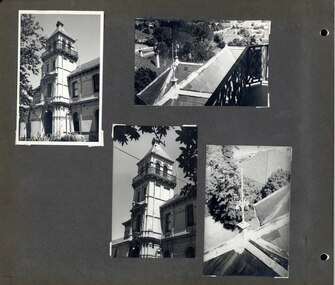
... The siting of Myoora on a ridge influenced its planning and composition. ...This photograph is part of the Caulfield Historical Album 1972. This album was created in approximately 1972 as part of a project by the Caulfield Historical Society to assist in identifying buildings worthy of preservation. The album is related to a Survey the Caulfield Historical Society developed in collaboration with the National Trust of Australia (Victoria) and Caulfield City Council to identify historic buildings within the City of Caulfield that warranted the protection of a National Trust Classification. Principal photographer thought to be Trevor Hart, member of Caulfield Historical Society. Most photographs were taken between 1966-1972 with a small number of photographs being older and from unknown sources. All photographs are black and white except where stated, with 386 photographs over 198 pages.Victorian Heritage Register (VHR) Number H0490 From the Victorian Heritage Register Database - Citation for Myoora https://vhd.heritagecouncil.vic.gov.au/places/275 (as at 6/10/2020) Myoora, 405 Alma Road, North Caulfield, was designed by Reed, Henderson & Smart and can be attributed to Anketell Henderson. It was built in 1886 and 1887 for Thomas Christian, who had founded the fabled gold mine, the Day Dawn at Charters Towers. He never occupied the house although his widow lived there for some time. The house was subdivided into three and later six flats. Myoora was one of many large mansions on broad acres with gardens in Caulfield. Perhaps the grandest was Labassa. The mansions date from the 1850s through to the late 1890s. The siting of Myoora on a ridge influenced its planning and composition. A central hall and corridor along the ridge is entered from the centre of the more formal north facade. The entrance is marked by an elaborately detailed tower. A stair turret provides a second accent. The western end of the building is completed by a massively detailed chimney as the service wing. The south facade enjoyed an outlook to port phillip from a two-storey cast iron verandah. Bay windows, chimneys, the tower and the turret and minor details are brought together in a sophisticated asymmetrical composition. This is reflected in the planning. The asymmetry of Myoora pivoting on the tower is the most notable feature of the building. The walls are built of cement rendered brick. The cement render has not been painted. The roof is slate. The balconies and verandah are cast iron. The footings and cellar are bluestone. The architectural firm Reed, Henderson & Smart was very prominent in Victoria in the nineteenth century. Anketell Henderson was an eminent and well respected member of the profession. He worked successfully in London and interstate as well as in Victoria. They were better known for commercial and public buildings. Myoora is an important private commission. The style of Myoora is a combination of details from the Continental and English Renaissance through the boom style and the Queen Anne style. There is also an early influence from the American Romanesque style especially in the stair turret. The latter style was important at the turn of the century and Myoora is a significant precursor. Other buildings of a similar scale survive in Caulfield and elsewhere. Labassa, the most fabulous, is quite different stylistically as are most of the other comparable mansions. Stonnington is perhaps closer but relies on different details from the Queen Anne style and lacks any American influence. For its historical associations through its owners and architects, for its style and composition and for its intactness, Myoora is significant at a State level. The craftmanship of Myoora is what could be expected of a building of the time and type. It is relatively intact and in fair condition. The main staircase has been removed, minor alterations to decorative features have occurred and additions have been made to the exterior.Page 14 of Photograph Album including two black and white photographs that are arranged in landscape orientation in the centre of the page with one beneath the other. Handwritten: "Myoora" 405 Alma Road [top right] /Neg 87 c1890 [under top photo]/ Neg 89 c1890/ [under bottom photo]/ 14 [bottom right]caulfield north, trevor hart, alma road, mansion, myoora, tower, thomas christian, 1880's, queen anne, cement rendered brick, unpainted, balconies, verandahs, anketell henderson, continental and english renaissance, american romanesque, cast iron balconies, gardens, views, cast iron work, reed henderson & smart, flats, asymmetrical style, slate roofs -
 Glen Eira Historical Society
Album - Album page, Myoora, 405 Alma Road, Circa 1972
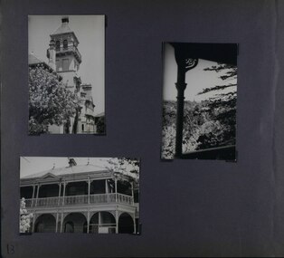
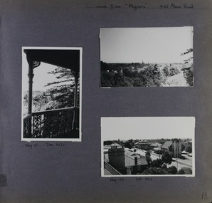
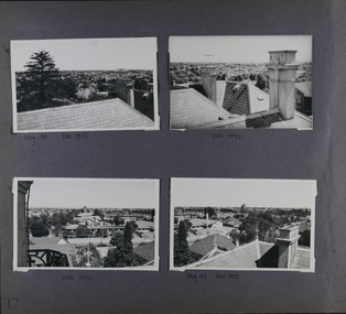
... The siting of Myoora on a ridge influenced its planning and composition. ...This photograph is part of the Caulfield Historical Album 1972. This album was created in approximately 1972 as part of a project by the Caulfield Historical Society to assist in identifying buildings worthy of preservation. The album is related to a Survey the Caulfield Historical Society developed in collaboration with the National Trust of Australia (Victoria) and Caulfield City Council to identify historic buildings within the City of Caulfield that warranted the protection of a National Trust Classification. Principal photographer thought to be Trevor Hart, member of Caulfield Historical Society. Most photographs were taken between 1966-1972 with a small number of photographs being older and from unknown sources. All photographs are black and white except where stated, with 386 photographs over 198 pages.Victorian Heritage Register (VHR) Number H0490 From the Victorian Heritage Register Database - Citation for Myoora https://vhd.heritagecouncil.vic.gov.au/places/275 (as at 6/10/2020) Myoora, 405 Alma Road, North Caulfield, was designed by Reed, Henderson & Smart and can be attributed to Anketell Henderson. It was built in 1886 and 1887 for Thomas Christian, who had founded the fabled gold mine, the Day Dawn at Charters Towers. He never occupied the house although his widow lived there for some time. The house was subdivided into three and later six flats. Myoora was one of many large mansions on broad acres with gardens in Caulfield. Perhaps the grandest was Labassa. The mansions date from the 1850s through to the late 1890s. The siting of Myoora on a ridge influenced its planning and composition. A central hall and corridor along the ridge is entered from the centre of the more formal north facade. The entrance is marked by an elaborately detailed tower. A stair turret provides a second accent. The western end of the building is completed by a massively detailed chimney as the service wing. The south facade enjoyed an outlook to Port Phillip from a two-storey cast iron verandah. Bay windows, chimneys, the tower and the turret and minor details are brought together in a sophisticated asymmetrical composition. This is reflected in the planning. The asymmetry of Myoora pivoting on the tower is the most notable feature of the building. The walls are built of cement rendered brick. The cement render has not been painted. The roof is slate. The balconies and verandah are cast iron. The footings and cellar are bluestone. The architectural firm Reed, Henderson & Smart was very prominent in Victoria in the nineteenth century. Anketell Henderson was an eminent and well respected member of the profession. He worked successfully in London and interstate as well as in Victoria. They were better known for commercial and public buildings. Myoora is an important private commission. The style of Myoora is a combination of details from the Continental and English Renaissance through the boom style and the Queen Anne style. There is also an early influence from the American Romanesque style especially in the stair turret. The latter style was important at the turn of the century and Myoora is a significant precursor. Other buildings of a similar scale survive in Caulfield and elsewhere. Labassa, the most fabulous, is quite different stylistically as are most of the other comparable mansions. Stonnington is perhaps closer but relies on different details from the Queen Anne style and lacks any American influence. For its historical associations through its owners and architects, for its style and composition and for its intactness, Myoora is significant at a State level. The craftmanship of Myoora is what could be expected of a building of the time and type. It is relatively intact and in fair condition. The main staircase has been removed, minor alterations to decorative features have occurred and additions have been made to the exterior.Page 16 of Photograph Album including three black and white photographs. Two are arranged in landscape orientation on the right hand side of the page with the other photo in portrait mode on the left hand side. Handwritten: views from "Myoora" 405 Alma Road [top right] / Neg 181 Dec 1972 [under left side photo] / Neg 189 Dec 1972 [under bottom right photo] / 16 [bottom right]caulfield north, trevor hart, alma road, mansion, myoora, tower, thomas christian, 1880's, queen anne, cement rendered brick, unpainted, balconies, verandahs, anketell henderson, continental and english renaissance, american romanesque, cast iron balconies, panoramic views, streetscapes, cast iron work, reed henderson & smart, gardens, asymmetrical style, slate roofs, chimneys -
 Glen Eira Historical Society
Album - Album page, Myoora, 405 Alma Road, Circa 1972
... The siting of Myoora on a ridge influenced its planning and composition. ...This photograph is part of the Caulfield Historical Album 1972. This album was created in approximately 1972 as part of a project by the Caulfield Historical Society to assist in identifying buildings worthy of preservation. The album is related to a Survey the Caulfield Historical Society developed in collaboration with the National Trust of Australia (Victoria) and Caulfield City Council to identify historic buildings within the City of Caulfield that warranted the protection of a National Trust Classification. Principal photographer thought to be Trevor Hart, member of Caulfield Historical Society. Most photographs were taken between 1966-1972 with a small number of photographs being older and from unknown sources. All photographs are black and white except where stated, with 386 photographs over 198 pages.Victorian Heritage Register (VHR) Number H0490 From the Victorian Heritage Register Database - Citation for Myoora https://vhd.heritagecouncil.vic.gov.au/places/275 (as at 6/10/2020) Myoora, 405 Alma Road, North Caulfield, was designed by Reed, Henderson & Smart and can be attributed to Anketell Henderson. It was built in 1886 and 1887 for Thomas Christian, who had founded the fabled gold mine, the Day Dawn at Charters Towers. He never occupied the house although his widow lived there for some time. The house was subdivided into three and later six flats. Myoora was one of many large mansions on broad acres with gardens in Caulfield. Perhaps the grandest was Labassa. The mansions date from the 1850s through to the late 1890s. The siting of Myoora on a ridge influenced its planning and composition. A central hall and corridor along the ridge is entered from the centre of the more formal north facade. The entrance is marked by an elaborately detailed tower. A stair turret provides a second accent. The western end of the building is completed by a massively detailed chimney as the service wing. The south facade enjoyed an outlook to port phillip from a two-storey cast iron verandah. Bay windows, chimneys, the tower and the turret and minor details are brought together in a sophisticated asymmetrical composition. This is reflected in the planning. The asymmetry of Myoora pivoting on the tower is the most notable feature of the building. The walls are built of cement rendered brick. The cement render has not been painted. The roof is slate. The balconies and verandah are cast iron. The footings and cellar are bluestone. The architectural firm Reed, Henderson & Smart was very prominent in Victoria in the nineteenth century. Anketell Henderson was an eminent and well respected member of the profession. He worked successfully in London and interstate as well as in Victoria. They were better known for commercial and public buildings. Myoora is an important private commission. The style of Myoora is a combination of details from the Continental and English Renaissance through the boom style and the Queen Anne style. There is also an early influence from the American Romanesque style especially in the stair turret. The latter style was important at the turn of the century and Myoora is a significant precursor. Other buildings of a similar scale survive in Caulfield and elsewhere. Labassa, the most fabulous, is quite different stylistically as are most of the other comparable mansions. Stonnington is perhaps closer but relies on different details from the Queen Anne style and lacks any American influence. For its historical associations through its owners and architects, for its style and composition and for its intactness, Myoora is significant at a State level. The craftmanship of Myoora is what could be expected of a building of the time and type. It is relatively intact and in fair condition. The main staircase has been removed, minor alterations to decorative features have occurred and additions have been made to the exterior.Page 17 of Photograph Album including four black and white photographs. All are arranged in landscape orientation with two on the top half of the page and the other two below.Handwritten: Neg 185 Dec 1972 [under top left photo] / Dec 1972 [under top right photo] / Dec 1972 [under bottom left photo] / Neg 153 Dec 1972 [under bottom right photo] / 17 [bottom left]caulfield north, trevor hart, alma road, mansion, myoora, tower, thomas christian, 1880's, queen anne, cement rendered brick, unpainted, balconies, verandahs, anketell henderson, continental and english renaissance, american romanesque, cast iron balconies, panoramic views, streetscapes, cast iron work, reed henderson & smart, gardens, asymmetrical style, slate roofs -
 Glen Eira Historical Society
Album - Album page, Myoora, 405 Alma Road, Circa 1972
... The siting of Myoora on a ridge influenced its planning and composition. ...This photograph is part of the Caulfield Historical Album 1972. This album was created in approximately 1972 as part of a project by the Caulfield Historical Society to assist in identifying buildings worthy of preservation. The album is related to a Survey the Caulfield Historical Society developed in collaboration with the National Trust of Australia (Victoria) and Caulfield City Council to identify historic buildings within the City of Caulfield that warranted the protection of a National Trust Classification. Principal photographer thought to be Trevor Hart, member of Caulfield Historical Society. Most photographs were taken between 1966-1972 with a small number of photographs being older and from unknown sources. All photographs are black and white except where stated, with 386 photographs over 198 pages.Victorian Heritage Register (VHR) Number H0490 From the Victorian Heritage Register Database - Citation for Myoora https://vhd.heritagecouncil.vic.gov.au/places/275 (as at 6/10/2020) Myoora, 405 Alma Road, North Caulfield, was designed by Reed, Henderson & Smart and can be attributed to Anketell Henderson. It was built in 1886 and 1887 for Thomas Christian, who had founded the fabled gold mine, the Day Dawn at Charters Towers. He never occupied the house although his widow lived there for some time. The house was subdivided into three and later six flats. Myoora was one of many large mansions on broad acres with gardens in Caulfield. Perhaps the grandest was Labassa. The mansions date from the 1850s through to the late 1890s. The siting of Myoora on a ridge influenced its planning and composition. A central hall and corridor along the ridge is entered from the centre of the more formal north facade. The entrance is marked by an elaborately detailed tower. A stair turret provides a second accent. The western end of the building is completed by a massively detailed chimney as the service wing. The south facade enjoyed an outlook to port phillip from a two-storey cast iron verandah. Bay windows, chimneys, the tower and the turret and minor details are brought together in a sophisticated asymmetrical composition. This is reflected in the planning. The asymmetry of Myoora pivoting on the tower is the most notable feature of the building. The walls are built of cement rendered brick. The cement render has not been painted. The roof is slate. The balconies and verandah are cast iron. The footings and cellar are bluestone. The architectural firm Reed, Henderson & Smart was very prominent in Victoria in the nineteenth century. Anketell Henderson was an eminent and well respected member of the profession. He worked successfully in London and interstate as well as in Victoria. They were better known for commercial and public buildings. Myoora is an important private commission. The style of Myoora is a combination of details from the Continental and English Renaissance through the boom style and the Queen Anne style. There is also an early influence from the American Romanesque style especially in the stair turret. The latter style was important at the turn of the century and Myoora is a significant precursor. Other buildings of a similar scale survive in Caulfield and elsewhere. Labassa, the most fabulous, is quite different stylistically as are most of the other comparable mansions. Stonnington is perhaps closer but relies on different details from the Queen Anne style and lacks any American influence. For its historical associations through its owners and architects, for its style and composition and for its intactness, Myoora is significant at a State level. The craftmanship of Myoora is what could be expected of a building of the time and type. It is relatively intact and in fair condition. The main staircase has been removed, minor alterations to decorative features have occurred and additions have been made to the exterior.Page 18 of Photograph Album including four black and white photographs. All are arranged in landscape orientation with two on the top half of the page and the other two below.Handwritten: views from "Myoora" 405 Alma Road / [top right hand] / Neg 188 Dec 1972 [under top left photo] / Dec 1972 [under top right photo] / Neg 184 Dec 1972 [under bottom left photo] / Neg 168 Dec 1972 [under bottom right photo] / 18 [bottom right]caulfield north, trevor hart, alma road, mansion, myoora, tower, thomas christian, 1880's, queen anne, turret, cement rendered brick, unpainted, balconies, verandahs, anketell henderson, continental and english renaissance, american romanesque, cast iron balconies, panoramic views, streetscapes, cast iron work, reed henderson & smart, asymmetrical style, gardens, slate roofs -
 The Beechworth Burke Museum
Photograph, c. 1927 - 1930
... influence of the farming communities along the river in this area - particularly in relation to the building of the Weir. It also represents the collaboration between New South Wales and Victoria on a large infrastructure project, being the only built structure shared by both New South Wales and Victoria due to its location. also reflecting on the Shire's geographical closeness to this neighboring state. This photograph is part of a series that documents the construction of this well-known heritage site ...Taken during the construction of the Bethanga Bridge (1927-1930), this sepia photograph shows a view of the incomplete bridge taken from inside the structure and looking down the span of the bridge from where the photographer stands. The photograph depicts an incomplete deck, with loose-looking wooden planks/panels lain along the centre in groups of three. Once complete, the original decking of the bridge was made of timber before being replaced by cement in 1961 (Victorian Heritage Database).Bethanga Bridge is of historical significance to the Indigo Shire for its associations with the construction of Hume Dam, its associations with the River Murray Waters Agreement and the River Murray Commission, and illustration of the needs and influence of the farming communities along the river in this area - particularly in relation to the building of the Weir. It also represents the collaboration between New South Wales and Victoria on a large infrastructure project, being the only built structure shared by both New South Wales and Victoria due to its location. also reflecting on the Shire's geographical closeness to this neighboring state. This photograph is part of a series that documents the construction of this well-known heritage site of significance to the Indigo Shire. It reflects upon a period of growth and change in the area.Sepia, rectangular photograph printed on matt photographic paper, unmountedReverse: 1997.3190 / Another snap of the bridge. taken on the bridge showing huge steel sides / 84-19-4 / V [in circle] 354 / KODAK PRINTbethanga bridge, hume dam, bridges album, construction, road construction, hume weir -
 The Beechworth Burke Museum
Geological specimen - Unknown, possible Carnelian Agate or Chalcedony
... The identification of sites containing valuable commodities such as gold, iron ore and gemstones in a locality had the potential to shape the development and history of communities and industries in the area. The discovery of gold in Victoria, for instance, had a significant influence...The identification of sites containing valuable commodities such as gold, iron ore and gemstones in a locality had the potential to shape the development and history of communities and industries in the area. The discovery of gold in Victoria, for instance, had a significant influence ...Although it is not known where these specimens were collected, Victoria and other regions of Australia were surveyed for sites of potential mineral wealth throughout the 19th Century. The identification of sites containing valuable commodities such as gold, iron ore and gemstones in a locality had the potential to shape the development and history of communities and industries in the area. The discovery of gold in Victoria, for instance, had a significant influence on the development of the area now known as 'the goldfields', including Beechworth; the city of Melbourne and Victoria as a whole. Agate occurs when amygdales (gas pockets) form in the upper levels of basaltic lava flows. If these pockets or bubbles are iniltrated by water bearing silica in solution, the fluid dries and hardens in layers, forming round or egg shaped nodules or geodes within the rocky matrix. Agate is formed of a silica mineral chalcedony similar to quartz. The term carnelian primarily refers to the reddish shading of the stone; whether the stone is termed an agate or chalcedony type is often influenced by the degree of colour banding the specimen shows. The specimens are significant as examples of surveying activity undertaken to assess and direct the development of the mineral resource industries in Victoria and Australia, as well as the movement to expand human knowledge of earth sciences such as mineralogy and geology in the nineteenth century.Three small geological specimens that appear visually consistent with images of rough or unpolished Carnelian Agate or Chalcedony. geological specimen, geology, geology collection, burke museum, beechworth, indigo shire, north-east victoria, gemstones, agate, carnelian -
 The Beechworth Burke Museum
Geological specimen - Dolomite
... The identification of sites containing valuable commodities such as gold, iron ore and gemstones in a locality had the potential to shape the development and history of communities and industries in the area. The discovery of gold in Victoria, for instance, had a significant influence...The identification of sites containing valuable commodities such as gold, iron ore and gemstones in a locality had the potential to shape the development and history of communities and industries in the area. The discovery of gold in Victoria, for instance, had a significant influence ...Dolomite is a mineral, calcium magnesium carbonate, with the chemical formula CaMg(CO3)2. It is a principle component of various rock types sometimes also referred to as dolomite, including dolostone, dolomitic marble and dolomitic limestone (according to the composition of each type). Dolomite rock is found in sedimentary basins throughout the world, comprising approximately 2% of the Earth's crust. It is formed when lime mud or limestone encounters groundwater containing magnesium. Dolomite can contain elements such as lead, zinc and copper. Dolomite and limestone are used in various construction, landscaping and agricultural processes. This specimen was donated to the Burke Museum in 1868 by Alfred Selwyn as part of the Geological Survey of Victoria. It was donated to the Museum in 1868. Victoria and other regions of Australia were surveyed for sites of potential mineral wealth throughout the 19th Century. The identification of sites containing valuable commodities such as gold, iron ore and gemstones in a locality had the potential to shape the development and history of communities and industries in the area. The discovery of gold in Victoria, for instance, had a significant influence on the development of the area now known as 'the goldfields', including Beechworth; the city of Melbourne and Victoria as a whole. Dolomite and limestone are mined at several locations in Victoria, including sites in the North-East of the state in Bindi and Limestone Creek. There are notable dolomite deposits in most Australian states. The dolomitised form of the mineral tends to come from older limestone deposits, formed during the palaeozoic era in marine settings, so this specimen may have come from a deposit located along a coastline in Victoria or another state. The specimen is significant as an example of surveying activity undertaken to assess and direct the development of the mineral resource industries in Victoria and Australia, as well as the movement to expand human knowledge of earth sciences such as mineralogy and geology in the nineteenth century. This specimen is part of a larger collection of geological and mineral specimens collected from around Australia (and some parts of the world) and donated to the Burke Museum between 1868-1880. A large percentage of these specimens were collected in Victoria as part of the Geological Survey of Victoria that begun in 1852 (in response to the Gold Rush) to study and map the geology of Victoria. Collecting geological specimens was an important part of mapping and understanding the scientific makeup of the earth. Many of these specimens were sent to research and collecting organisations across Australia, including the Burke Museum, to educate and encourage further study.Hand-sized piece of pale pink dolomite (calcium magnesium carbonate) with dark grey rim and hollowed centre. geological specimen, geology, geology collection, burke museum, beechworth, dolomite, mineralogy, geological survey, alfred selwyn, limestone, calcium magnesium carbonate -
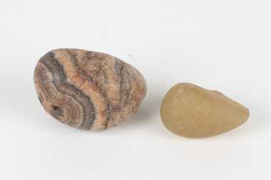 The Beechworth Burke Museum
Geological specimen - Agate and Quartz pebbles
... The identification of sites containing valuable commodities such as gold, iron ore and gemstones in a locality had the potential to shape the development and history of communities and industries in the area. The discovery of gold in Victoria, for instance, had a significant influence...The identification of sites containing valuable commodities such as gold, iron ore and gemstones in a locality had the potential to shape the development and history of communities and industries in the area. The discovery of gold in Victoria, for instance, had a significant influence ...Agate occurs when amygdales (gas pockets) form in the upper levels of basaltic lava flows. If these pockets or bubbles are iniltrated by water bearing silica in solution, the fluid dries and hardens in layers, forming round or egg shaped nodules or geodes within the rocky matrix. Agate is formed of a silica mineral chalcedony similar to quartz. Although relatively common and semi-precious, agate has been prized since at least 1450 BC - an intricately carved agate seal was found in the 2015 excavation of a grave belonging to a Mycenaeum priest or warrior near Pylos in Greece. Agate is also used in jewellery and other decorative or ritual purposes due to its often striking appearance. Quartz is found all over Australia, including Beechworth in Victoria. It is formed in deep-seated igneous rocks and crystallized through hot aqueous solutions. It can have two forms; Microcrystalline quartz or Crystalline quartz. Microcrystalline quartz is a fine grain quartz where crystalline quartz is often a large crystal. The colour of quartz can vary. These specimens were collected in Victoria in the vicinity of the Burke Museum. Victoria and other regions of Australia were surveyed for sites of potential mineral wealth throughout the 19th Century. The identification of sites containing valuable commodities such as gold, iron ore and gemstones in a locality had the potential to shape the development and history of communities and industries in the area. The discovery of gold in Victoria, for instance, had a significant influence on the development of the area now known as 'the goldfields', including Beechworth; the city of Melbourne and Victoria as a whole.The specimens are significant as examples of surveying activity undertaken to assess and direct the development of the mineral resource industries in Victoria and Australia, as well as the movement to expand human knowledge of earth sciences such as mineralogy and geology in the nineteenth century.Geological specimens of Agate and Quartz respectively; the fist-sized piece of Agate has peach/coral colouring with grey concentric patterning and the smaller piece of quartz is a uniform yellow/orange shade. Existing label: Local pebbles / (agate and / quartz / (yellowish) / egg-shaped). / BB geological specimen, geology, geology collection, burke museum, beechworth, agate, quartz, north-east victoria, indigo shire, geological surveys -
 The Beechworth Burke Museum
Geological specimen - North Queensland Agates, Unknown
... The identification of sites containing valuable commodities such as gold, iron ore and gemstones in a locality had the potential to shape the development and history of communities and industries in the area. The discovery of gold in Victoria, for instance, had a significant influence...The identification of sites containing valuable commodities such as gold, iron ore and gemstones in a locality had the potential to shape the development and history of communities and industries in the area. The discovery of gold in Victoria, for instance, had a significant influence ...Agate occurs when amygdales (gas pockets) form in the upper levels of basaltic lava flows. If these pockets or bubbles are iniltrated by water bearing silica in solution, the fluid dries and hardens in layers, forming round or egg shaped nodules or geodes within the rocky matrix. Agate is formed of a silica mineral chalcedony similar to quartz. Although relatively common and semi-precious, agate has been prized since at least 1450 BC - an intricately carved agate seal was found in the 2015 excavation of a grave belonging to a Mycenaeum priest or warrior near Pylos in Greece. Agate is also used in jewellery and other decorative or ritual purposes due to its often striking appearance. These specimens originated in North Queensland, which contains noted agate-fossicking regions such as in the area surrounding Forsayth. They were collected in approximately 1852 as an adjunct to the Geological Survey of Victoria. It was donated to the Museum in 1868. Victoria and other regions of Australia were surveyed for sites of potential mineral wealth throughout the 19th Century. The identification of sites containing valuable commodities such as gold, iron ore and gemstones in a locality had the potential to shape the development and history of communities and industries in the area. The discovery of gold in Victoria, for instance, had a significant influence on the development of the area now known as 'the goldfields', including Beechworth; the city of Melbourne and Victoria as a whole. The specimens are significant as examples of surveying activity undertaken to assess and direct the development of the mineral resource industries in Victoria and Australia, as well as the movement to expand human knowledge of earth sciences such as mineralogy and geology in the nineteenth century. Two solid egg-sized pieces of peach/orange toned agate (a common semi-precious chalcedony, similar to quartz) with a striped pattern, embedded in a light and dark brown matrix. geological specimen, geology, geology collection, burke museum, beechworth, agate, north queensland agate, 1852 geological survey of victoria, l. hufer - donor, mineralogy, agate specimen, indigo shire -
 The Beechworth Burke Museum
Geological specimen - Sphalerite, Unknown
... The identification of sites containing valuable commodities such as gold, iron ore and gemstones in a locality had the potential to shape the development and history of communities and industries in the area. The discovery of gold in Victoria, for instance, had a significant influence...The identification of sites containing valuable commodities such as gold, iron ore and gemstones in a locality had the potential to shape the development and history of communities and industries in the area. The discovery of gold in Victoria, for instance, had a significant influence ...Sphalerite or sphaelerite is named from the Greek word for 'treacherous' or 'deceiver' as specimens can vary widely in appearance, making them hard to visually identify. It is a zinc sulfide with the chemical composition (Zn,Fe)S, the most important ore of zinc. Specimens of sphalerite can contain iron as a substitute for up to 25% of the usual zinc present, as well as trace elements of gallium, cadmium, geranium and indium. Small amounts of arsenic and manganese may also be detected. Sphalerite is found in igneous, sedimentary and metamorphic rocks. It forms when carbonate rock encounters acidic, zinc-bearing fluid. It often forms in veins or in fissures of the existing rock, with colours and crystal shapes dependent on the composition of the the combining elements. It forms isometric crystal shapes including cubes, tetrahedrons, octahedrons, dodecahedrons. This specimen was collected in approximately 1852, in Broken Hill, NSW, as an adjunct to the Geological Survey of Victoria. It was donated to the Museum in 1868. Victoria and other regions of Australia were surveyed for sites of potential mineral wealth throughout the 19th Century. The identification of sites containing valuable commodities such as gold, iron ore and gemstones in a locality had the potential to shape the development and history of communities and industries in the area. The discovery of gold in Victoria, for instance, had a significant influence on the development of the area now known as 'the goldfields', including Beechworth; the city of Melbourne and Victoria as a whole.The specimen is significant as an examples of surveying activity undertaken to assess and direct the development of the mineral resource industries in Victoria and Australia, as well as the movement to expand human knowledge of earth sciences such as mineralogy and geology in the nineteenth century.A pipe-shaped specimen of sulfide-mineral zinc ore displaying patches of black, brown, beige and gold colouring. The main item has associated broken pieces. geological specimen, geology, geology collection, burke museum, beechworth, mineralogy, indigo shire, geological survey, sphalerite, sphaelerite, zinc ore, broken hill, nsw, victoria, galena, fluorite, chalcopyrite, lead, cadmium, gallium, germanium, indium, iron -
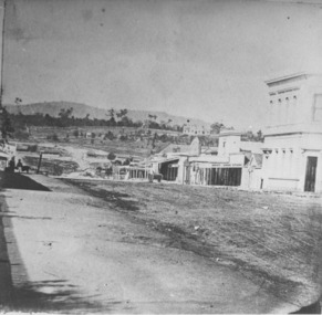 The Beechworth Burke Museum
Photograph
... sited addition to the front of the original building. Extensive internal renovations have also been made to the original buildings. [https://vhd.heritagecouncil.vic.gov.au/places/118] The Ovens and Murray Hospital for the Aged is of architectural significance as an unusual example of Flemish influenced design from the 1860s. ...Taken in Beechworth, this photograph depicts the business of Camp Street looking towards the Ovens and Murray Benevolent Asylum. In the foreground of right hand side; there are row of buildings, on the left hand side; there are a two standing figures. The Ovens Benevolent Asylum (or the Ovens and Murray Hospital for the Aged) was constructed in 1862 on an elevated site overlooking the township of Beechworth. This Asylum was built in response to boom in population due to the discovery of Gold in Beechworth in 1852. This period also saw the development of additional administration buildings such as; the Court house, the Town Hall, and offices. The original Benevolent Asylum building was designed in an unusual Flemish Gothic Revival style. The single storey building is of red brick on a dressed granite base, and the main facade is dominated by four curved, Flemish gable ends, those at the extremities being added to the original central section in 1867. This facade incorporates paired windows of pointed Gothic form and dark brick diaperwork patterning. The adjacent J. A. Wallace Wing of 1899 was designed by Donald Fiddes as a separate building. Also constructed of red brick, Fiddes adopted a conservative approach, designing a simple domestic scale building with central projecting gable porch and flanking bull nosed verandahs. The Benevolent Asylum was renamed the Ovens Benevolent Home in 1935 and The Ovens and Murray Home in 1954. Many buildings have been added to this site, particularly since the 1960s, including a poorly sited addition to the front of the original building. Extensive internal renovations have also been made to the original buildings. [https://vhd.heritagecouncil.vic.gov.au/places/118]The Ovens and Murray Hospital for the Aged is of architectural significance as an unusual example of Flemish influenced design from the 1860s. Although the facade has been partly obscured, it remains intact, and, together with the more simply designed Wallace wing, are important examples of early buildings designed for the specific purpose of aged care. The Flemish gables remain as a dominant form of Beechworth's urban landscape. The Ovens and Murray Hospital for the Aged is of historical significance due to its association with the early development of Beechworth and its dominant siting within the town. It is illustrative of the civic development that took place in the town after the peak of the gold rush, when Beechworth was develpoing as the administrative centre of the north east of Victoria. [https://vhd.heritagecouncil.vic.gov.au/places/118]Black and white rectangular photograph. Image is printed on matte photographic paper. Obverse: BOOT SHOE STORE Reverse: 7770.2 / 1997.3099beechworth, burke museum, diggings, camp street, the benevolent asylum, ovens benevolent hom, gold rush -
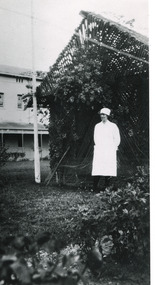 The Beechworth Burke Museum
Photograph - Photograph Reproduction, 1998
... influenced by the asylum at Colney Hatch in England. Large masses of granite were excavated for its foundation and around 250 workmen were employed for its construction. The building, divided into six sections, was comprised of dormitories, doctors` rooms and plenty ancillary rooms and facilities, such as laundries, reading rooms, a concert hall and cooking areas. The site...influenced by the asylum at Colney Hatch in England. Large masses of granite were excavated for its foundation and around 250 workmen were employed for its construction. The building, divided into six sections, was comprised of dormitories, doctors` rooms and plenty ancillary rooms and facilities, such as laundries, reading rooms, a concert hall and cooking areas. The site ...The photograph, created in 1998, is a copy of the original one, depicting a nurse in uniform at the Mental Hospital in Beechworth, with a fern house behind her. In the background, the two-storey building is in view, along with the covered walkway. The institution had to operate with serious shortage of female nurses for long periods of time. During the 1880s, small houses (cottages) were built to offer accommodation for the nurses living in the hospital and in 1937 began the construction of a nurses` hostel. In 1962 the upper level of the Nurses` Home was converted into a Nurses` Training School. The Mayday Hills Hospital was constructed between 1864 and 1867, with buildings created in a number of periods. It formally opened on 24 October 1867 and, along with the Ovens Hospital and the Benevolent Asylum, made Beechworth a prominent social welfare centre in Victoria. The need for an institution of this kind was arisen due to the increased number of people with mental disturbances (induced by the harsh living conditions on the goldfields) and the remoteness of the district from Melbourne. The two-storey buildings, designed in Italianate style, and the three-storey towers at the front, were influenced by the asylum at Colney Hatch in England. Large masses of granite were excavated for its foundation and around 250 workmen were employed for its construction. The building, divided into six sections, was comprised of dormitories, doctors` rooms and plenty ancillary rooms and facilities, such as laundries, reading rooms, a concert hall and cooking areas. The site was chosen for its panoramic view of the countryside, the hilltop atmosphere and the native fauna, all contributing to the cure of patients. The Hospital was originally named the “Ovens Lunatic Asylum” but, during the centenary celebrations in 1967, the name was officially changed to “Mayday Hills Hospital”, showing the gradual shift in the perception and understanding of mental health conditions over the last decades. The Hospital lies on the traditional land of the Kulin Nation.This photograph is historically significant as it provides an insight into the everyday life of staff living within the walls of the Mayday Hills Hospital. It also offers important information about the location and the exterior of the Hospital and contributes to the understanding of the district`s development and its importance to the course of Victoria`s history.Black and white rectangular photograph printed on paper unframed.Reverse: 3445/mental hospital, beechworth, fern house, female nurses, nurses` home, nurses` training school, nurses` hostel, mayday hills hospital, ovens hospital, colney hatch, two-storey buildings, italianate style, benevolent asylum, ovens lunatic asylum, kulin nation, workmen, covered walkway, granite, hilltop atmosphere, mental health -
 Bendigo Historical Society Inc.
Plan - Victoria Quartz Gold Mine
... influence on Bendigo, originated from mining operations carried out on the hill. The Victoria Hill Quartz Gold Mines are historically and scientifically important as characteristic examples of an important form of gold mining. Gold mining sites...influence on Bendigo, originated from mining operations carried out on the hill. The Victoria Hill Quartz Gold Mines are historically and scientifically important as characteristic examples of an important form of gold mining. Gold mining sites ...The Victoria Quartz Gold Mine was situated on Victoria Hill, Ironbark, (1877 - 1913). At the turn of the century, this was the site of one of the premier mines on the Bendigo goldfield. In 1908, it boasted the world's deepest shaft - 4,478 feet (1,365 metres). The shaft reached a depth of 4,613 feet (1,406 metres) in 1910. In 1857 eight small claims in this area had been merged to form the Victoria Reef Quartz Mining Co. Another merger in 1877 led to the formation of the Victoria Quartz Co. For the next three decades, the mine produced consistent profits. In 1910, water burst into the claim, flooding the shaft and halting operations. The company baled water for six months then handed the mine over to the tributers who worked the upper levels for the share of the profits. The mine closed in 1913, having produced over 48,000 ounces of gold and paid dividends of £99,600. (Source, Goldfield Guide https://www.goldfieldsguide.com.au/explore-location/400/victoria-hill-mining-reserve/) Victorian Heritage Register information on mine: Statement of Significance Last updated on - July 14, 2005 The story of quartz mining on Victoria Hill lies at the heart of Bendigo's historical status as the world's richest and deepest reefing field. Gold was discovered on Victoria Hill in 1854, and by early 1855 claims had been taken up over its entire extent. Shafts were first worked by windlass, whip or whim, and primitive crushing batteries were in operation. By 1861, Victoria Hill had yielded at least 1,200,000oz in gold. One of the early claims on Victoria Hill was owned by Prussian immigrants, Christopher Ballerstedt and his son Theodore. In 1854, they bought a claim on the hill for £80, to which they subsequently added other claims, and from the quartz veins (called spurs), worked both by shafts and a large open cut, obtained gold worth nearly £200,000. Christopher Ballerstedt was dubbed 'Father of the Hill' and has been credited as the first to debunk the theory at that time prevalent on the Bendigo field, that the gold content of reefs would diminish at depth. As his shafts plunged below the 200-foot level, the quartz remained rich in gold. His success inspired others, and so led the way to Bendigo's later status as the world's deepest and richest goldfield. The Ballerstedt's built Bendigo's grandest mansion, Fortuna. Theodore continued to work Victoria Hill after his father's death, but in 1871, convinced that his claim was exhausted, he sold both mine and mansion to George Lansell for £60,000. Lansell's mine on Victoria Hill was called the 180, and operated under his ownership until his death in 1906. The mine supplied the initial wealth that made Lansell Bendigo's 'Quartz King'. George Lansell was such a force in Bendigo's mining history that his death was cited as one of the reasons for the decline of Bendigo as a quartz mining centre, The Victoria Hill Quartz Gold Mines are of historical, archaeological and scientific importance to the State of Victoria. The Victoria Hill Quartz Gold Mines are historically significant as the symbolic heart of Bendigo's famous goldfield. The mines are linked to nineteenth-century individuals (Christopher Ballerstedt and George Lansell) who played prominent roles in the evolution of Bendigo. Both men's fortunes and their influence on Bendigo, originated from mining operations carried out on the hill. The Victoria Hill Quartz Gold Mines are historically and scientifically important as characteristic examples of an important form of gold mining. Gold mining sites are of crucial importance for the pivotal role they have played since 1851 in the development of Victoria. As well as being a significant producer of Victoria's nineteenth century wealth, quartz mining, with its intensive reliance on machinery, played an important role in the development of Victorian manufacturing industry. The Victoria Hill Quartz Gold Mines are important as a manifestation of this aspect of gold mining. The Victoria Hill Quartz Gold Mines are scientifically important, as they contain relics span nearly sixty years of mining (1854 to 1913), documenting the richest and most significant years of Bendigo's world-famous quartz mining industry. Enhancing the significance of the place are relics from the Victoria Quartz Company operations, ncluding, at 4,870 feet, the world's deepest nineteenth-century gold mining shaft. As a postscript to the chronology of gold mining is the surviving crushing machinery (formerly part of the Bendigo Crushing Works) which was erected near the foundations of Lansell's 180 mine in 1932, to crush quartz for nearby mines. The place has a potential to yield artefacts and evidence which will be able to provide significant information about the technological history of gold mining. [Source: Victorian Heritage Register] Hermes Number 8506 https://vhd.heritagecouncil.vic.gov.au/index.php/places/8506/download-report Hand drawn plan of the bottom section of the Victoria Quartz Gold Mine. Mine shaft shown from 2706 feet to 5200 (potential) feet shown, with annotation regarding geological features and gold obtained from different level crushings. Blue border sticker on outside of plan: '13 BC 23 Victoria Quartz Trans-Section'. Plan is not dated. The Victoria Quartz plan is part of the Margaret Roberts Collection.victoria hill quartz gold mine, victoria hill -
 Ringwood and District Historical Society
Letter, The Larkin Family - History of Yarra Valley Grammar School Site, Ringwood, 2012
... Re; The Larkin Family I read with interest the article in the Link about the history of the school site and the previous ownership by the Larkin Family. That interest was influenced, of course, by the fact that the site was acquired on behalf of the school by my father Allan Ballard Carter who was an inaugural and foundation member of the School Council. ...Re; The Larkin Family I read with interest the article in the Link about the history of the school site and the previous ownership by the Larkin Family. That interest was influenced, of course, by the fact that the site was acquired on behalf of the school by my father Allan Ballard Carter who was an inaugural and foundation member of the School Council. ...4-page typewritten letter dated 28 May 2012 from Richard Carter (Carter Real Estate) to Mr John Close, Archivist, Yarra Valley Grammar School, Kalinda Road, Ringwood Vic 3134 detailing research findings relating to the history of the school site and previous ownership by the Larkin Family.28 May 2012 Mr John Close Archivist Yarra Valley Grammar School Kalinda Road RINGWOOD VIC 3134 Dear John. Re; The Larkin Family I read with interest the article in the Link about the history of the school site and the previous ownership by the Larkin Family. That interest was influenced, of course, by the fact that the site was acquired on behalf of the school by my father Allan Ballard Carter who was an inaugural and foundation member of the School Council. I set about undertaking my research. Crown Grant Volume 1700 Folio 927 shows that "Thomas Larkin of Ringwood" purchased 51 acres 2 roods 22 perches(about 20.9 hectares) being Crown Allotment 40 in the Parish of Warrandyte from the Crown on 9 March 1885 for 52 pounds, being the prevailing rate of 1 pound per acre or part thereof. That land fronted two government roads, now known as Kalinda Road and Plymouth Road but earlier known as Wonga Park Road and Wonga Road. The distinctive kink in the school's Plymouth Road frontage dotes from that time. Adjacent to the land, on the corner of those two roads, was Crown Allotment 40A which you identify as having been acquired by Richard Wilioughby in 1876. That title contained an area of exactly 20 acres (8.09 hectares). Larkin's Crown Grant then notes that Michael Larkin of Victoria Street Camberwell, Gentleman, and Norah Larkin of Warrandyte, Widow, took title on 22 June 1892 as Executor Executrix of the Will of Thomas Larkin who died on 10 May 1891. Norah Larkin was presumably the widow of Thomas Larkin. The address ("of Warrandyte") is significant. She might not have been living on the land. Alternatively, the North Croydon locality could easily have been referred to as "Warrandyte". Was Michael Larkin the son, brother or even the father of Thomas Larkin? The title holds a few clues. -2- The next transfer was Norah Larkin as surviving executor of the Will of Thomas Larkin. That endorsement is dated 9 August 1909, obviously after the death of Michael Larkin. Perhaps he was, indeed, Thomas' father. That endorsement immediately proceeded the transfer on the same day of the date of the title into Norah's name absolutely, and not simply as Executrix of her late husband's estate. Norah Larkin died on 5 April 1918 and probate of her Will was granted to Thomas Larkin of Wonga Road Warrandyte, Fruit-grower. We can surmise that this Thomas was the son of Norah and her late husband Thomas and that the address "Wonga Road Warrandyte" could in reality have been what would be regarded as Plymouth Road Croydon, Thus, we can surmise that Thomas Larkin was operating an orchard on the land he was living in on 1918. Thomas Larkin took title to the property in his right in 1923 and held it until his death in August 1939. Probate of Thomas Larkin's Will was granted to Eileen Molloy of Healesville Road Ringwood and title was transferred into her name on 1 December 1939. Who was Eileen Molloy? Clearly she was not Thomas Larkin's daughter (she was a spinster), The address 'Healesville Road' refers to what is now Maroondah Highway, In fact the Molloy family lived on Maroondah Highway, west of Oban Road, not far from the land. Regardless of whether she was family or merely a friend, Eileen Molloy continued to hold the land until the land was sold for development, firstly to Parkmore Proprietory Limited in about 1958 and finally to Dehay Pty Ltd on 26 October 1960. Dehay Pty Ltd was a land development company of Mr David Hains of the Portland Property Group in Collins Street Melbourne. The company had land along Kalinda Road which was later subdivided into Grayling Crescent and into Chesney Drive and surrounding streets. Clearly the intention would have been to subdivide the Larkin and Molloy lands (together with Willoughby's land) into residential allotments. -3- !t was at about this time that Mr A Robin Clarke had conceived the idea of an independent boy's school in the location and has approached my father, presumably both to select a suitable site and to serve on the school council which was about to be formed. Allan Carter was obviously aware in his professional capacity of the land and its ownership and identified it as a suitable site for a school. He approached Mr Hains with a proposal to sell and was able to secure an agreement. I recall my father some years later commenting to me that Mr Hains could well have regarded the approach as ill-conceived and an approach merely by a loose consortium with many bright ideas, hopes and aspirations but no money! It is probably a testament to the calibre of Robin Clarke and those around him that David Hains was persuaded of the greater good in selling the land and enable the school to take root. The school took title of three parcels of land, being the whole of the Larkin Land and the Willoughby Land (which had been split in two in 1890) on 13 January 1964. The entire site which totalled 71.6376 acres was purchased for a price of t52,750. The transfer was signed by David Hains as Vendor on behalf of Dehay Pty Ltd and by J B Harper & R F Hughes on behalf of the school. The rest, as they say, is history. As an aside, I understand David Hains is still alive with active business interests. As perhaps the last survivor of events surrounding the purchase of the site, it might be prudent for the school to ascertain whether he would care to detail for the record the circumstances which lead to his purchase of the Larkin/Molloy/Willoughby lands and his sale to the school. The Willoughby Land also holds some history. Richard William Willoughby held his 20 acres on the corner from the date of the Crown Grant in 1876 only until his death in 1877. His executors continued to own it until 1890 when it was split in two and the northern portion of about 10 acres sold to Hugh Ta\A4on Knight of Spencer Street Melbourne, That portion was later sold in 1897 to William George Long of Melbourne, Fruit Merchant who. in turn, in 1903 sold it to his neighbour. "Thomas Larkin of Ringwood, farmer" on 27 May 1903. It was then held by the Larkin/Molloy family until 1960 when it was sold to Parkmore Pty Ltd and then, in 1961, to Dehay Pty Ltd. -4- Meanwhile the southern portion of the Willoughby Land was sold to William George Long in 1897 (who held the northern portion) before being sold to James Maggs of Wonga Park Road (now Kalinda Road) Ringwood. It ultimately was also purchased by Dehay Pty Ltd. Yours faithfully Richard Carter -
 Flagstaff Hill Maritime Museum and Village
Domestic object - Basket, 1890-1920s
... Sites in the Middle East show that weaving techniques were used to make mats and possibly also baskets, circa 8000 BCE. Twined baskets date back to 7000 in Oasisamerica. Baskets made with interwoven techniques were common at 3000 BCE. Baskets were originally designed as multi-purpose vessels to carry and store materials and to keep stray items about the home. The plant life available in a region affects the choice of material, which in turn influences...Sites in the Middle East show that weaving techniques were used to make mats and possibly also baskets, circa 8000 BCE. Twined baskets date back to 7000 in Oasisamerica. Baskets made with interwoven techniques were common at 3000 BCE. Baskets were originally designed as multi-purpose vessels to carry and store materials and to keep stray items about the home. The plant life available in a region affects the choice of material, which in turn influences ...Before the invention of woven baskets, people used tree bark to make simple containers. These containers could be used to transport gathered food and other items but crumbled after only a few uses. Weaving strips of bark or other plant material to support the bark containers would be the next step, followed by entirely woven baskets. The last innovation appears to be baskets so tightly woven that they could hold water. Depending on soil conditions, baskets may or may not be preserved in the archaeological record. Sites in the Middle East show that weaving techniques were used to make mats and possibly also baskets, circa 8000 BCE. Twined baskets date back to 7000 in Oasisamerica. Baskets made with interwoven techniques were common at 3000 BCE. Baskets were originally designed as multi-purpose vessels to carry and store materials and to keep stray items about the home. The plant life available in a region affects the choice of material, which in turn influences the weaving technique. Rattan and other members of the Arecaceae or palm tree family, the thin grasses of temperate regions, and broad-leaved tropical bromeliads each require a different method of twisting and braiding to be made into a basket. The practice of basket making has evolved into an art. Artistic freedom allows basket makers with a wide choice of colours, materials, sizes, patterns, and details.Before the advent of plastics (1907), the is now used for many different types and styles of storage container rattan, wicker or cane was used to make containers with a lid for the storage of linens etc. The subject item was probability used at the end of the Victorian era and into the Edwardian period around the 1900s as a household storage facility. These types of wicker or cane containers started to go out of fashion due to their fragility around the 1920s into the 1940s due as well to the introduction of synthetic materials. Wicker cane rectangular shaped domestic storage container with reinforced leather pads on 4 corner sides. lid fits inside the other. Black cane piece around top edge.Noneflagstaff hill, warrnambool, shipwrecked-coast, flagstaff-hill, flagstaff-hill-maritime-museum, maritime-museum, shipwreck-coast, flagstaff-hill-maritime-village -
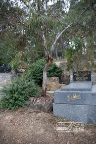 Eltham District Historical Society Inc
Photograph, Peter Pidgeon, Grave of Alistair Samuel Knox, Eltham Cemetery, Victoria, 5 April 2021
... Influenced by Frank Lloyd Wright and Walter Burley Griffin, he sought to create buildings that would blend into the landscape, enhanced by the planting of indigenous flora. The post-war shortage of building materials made traditional construction expensive. Adobe (mudbrick) provided a cheap and plentiful alternative, and one which would be aesthetically pleasing. Mud-brick manufacture was a problem at first. Sonia Skipper had been experimenting with Eltham clays for years to find the best mix for making bricks and render. Alistair employed her as building foreman on several of his sites...Influenced by Frank Lloyd Wright and Walter Burley Griffin, he sought to create buildings that would blend into the landscape, enhanced by the planting of indigenous flora. The post-war shortage of building materials made traditional construction expensive. Adobe (mudbrick) provided a cheap and plentiful alternative, and one which would be aesthetically pleasing. Mud-brick manufacture was a problem at first. Sonia Skipper had been experimenting with Eltham clays for years to find the best mix for making bricks and render. Alistair employed her as building foreman on several of his sites ...Alistair Knox was an environmental based designer and builder who came to Eltham in 1948. Influenced by Frank Lloyd Wright and Walter Burley Griffin, he sought to create buildings that would blend into the landscape, enhanced by the planting of indigenous flora. The post-war shortage of building materials made traditional construction expensive. Adobe (mudbrick) provided a cheap and plentiful alternative, and one which would be aesthetically pleasing. Mud-brick manufacture was a problem at first. Sonia Skipper had been experimenting with Eltham clays for years to find the best mix for making bricks and render. Alistair employed her as building foreman on several of his sites. By the 1980s, he had brought mud-brick and earth building into the Australian mainstream, and a Knox-designed house had become highly desirable. Sonia said that he would craft a bespoke earthen house to fit with his client's lifestyle. He was drawn to the environmental movement, publishing three books on housing and the environment, and speaking on radio. He also served on the Eltham Shire Council 1971-1975, was Shire President 1974 and was instrumental in re-establishing the Eltham Community Festival in 1975. Alistair died in 1986 and is buried in a small garden setting at Eltham Cemetery.Born Digitaleltham cemetery, gravestones, heritage excursion, alistair samuel knox