Showing 65 items matching "south crescent"
-
 Darebin Art Collection
Photograph, David Wadelton, Looking toward Westgarth Street from South Crescent, 1996
... Looking toward Westgarth Street from South Crescent...south crescent...south crescent Looking toward Westgarth Street from South ...south crescent -
 Brimbank City Council Art Collection
Photograph, Robert Pointon, Buckingham Crescent, South Sunshine, 1994
... Buckingham Crescent, South Sunshine...Buckingham Crescent, South Sunshine AR0115 ...Buckingham Crescent, South Sunshine, Western Suburbs... Scene Buckingham Crescent, South Sunshine AR0115 Buckingham ...Local SceneBuckingham Crescent, South Sunshine AR0115 -
 Eltham District Historical Society Inc
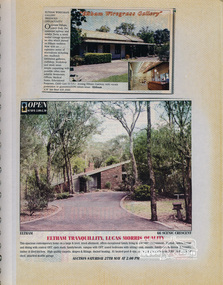
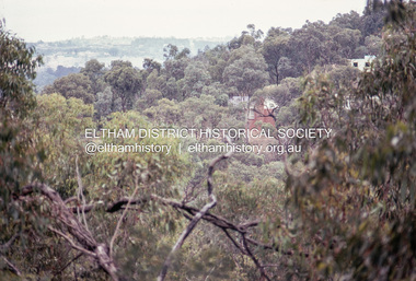
Newsclipping, Eltham Wiregrass Gallery, Main Road, Eltham South and 66 Scenic Crescent, Eltham, 1989
... Eltham Wiregrass Gallery, Main Road, Eltham South and 66... labelled "Houses - Eltham South" and Vol. 2 labelled "Eltham Houses ...Contained in Volume 1 of a set of two spiral magnetic photo albums, each containing 10 leaves, 20 pages; Vol. 1 labelled "Houses - Eltham South" and Vol. 2 labelled "Eltham Houses". Newspaper clippings advertising house auctionseltham, eltham south, real estate advertisement, houses, eltham lower park, eltham wiregrass gallery, ian reid real estate, main road, scenic crescent -
 City of Kingston
Pamphlet - Colour, Arthur Tuckett & Son, Auctioneers and Subdivisional Specialists, Auction of Station Estate, Moorabbin, 1923
... by Railway Crescent, South Road, Jasper Road and Pattersons Road.... Road, South Road and Railway Crescent. ... by Railway Crescent, South Road, Jasper Road and Pattersons Road ...Sales plan for land in the suburb of Moorabbin, bounded by Railway Crescent, South Road, Jasper Road and Pattersons Road.The developing urban area of Moorabbin within the City of Kingston. This land sale pamphlet illustrates the subdivision of land within the municipality and the changing demographic of the district as new houses are constructed.Colour pamphlet advertising an auction of the Station Estate Moorabbin. Incorporates details of the shopping facilities, proximity to the railway line, variety of schools and churches in the area, and a sales plan for home sites and shop fronts. Incorporates a map of the estate bordered by Pattersons Road, Japer Road, South Road and Railway Crescent. Handwritten in grey pencil top right front page: Station Estate / late [indecipherable] Handwritten in red pencil on subdivision map: x [on majority of properties marked on the map] Handwritten in grey pencil on subdivision map: additional subdivisions drawn in and large lines drawn across the mapmoorabbin, land sales, estate -
 Eltham District Historical Society Inc
Photograph, Thompson Crescent area, Research
... Crescent North 2. Reynolds Road/Thompson Crescent South 3. Reynolds.... Reynolds Road looking south from Thompson Crescent North 2 ...Three colour photographs of roads in the Thompson Crescent area, Research 1. Reynolds Road looking south from Thompson Crescent North 2. Reynolds Road/Thompson Crescent South 3. Reynolds Road/Thompson Crescent North, Researchthompson crescent, reynolds road, research -
 Robin Boyd Foundation
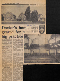
Newspaper - Clipping, The Age, Doctor's home geared for a big practice, 5-Jan-73
... and Dr James Barrett's house, all in Howe Crescent, South... and Dr James Barrett's house, all in Howe Crescent, South ...Article about a former Congregational Church and Hall and Dr James Barrett's house, all in Howe Crescent, South Melbourne. The connection to Robin Boyd not yet known.In pen "Robin Boyd Hall"walsh st library -
 Ringwood and District Historical Society
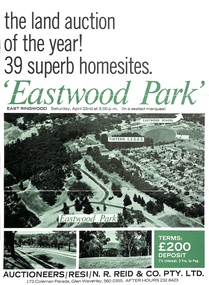
Document - Folder, Eastwood Park Subdivision, Ringwood East, Vic. - Land Sale Circa 1967 - Site of former Eastwood/Eastfield Golf Course
... Croydon South streets, Andrew Crescent and Banksia Court. Agents.... Subdivision includes Croydon South streets, Andrew Crescent ...Subdivision is advertised as including homesites on former Eastwood Golf Course fairways and land contours.Collection of subdivision maps, and double-sided advertisement for auction sale on Saturday, April 22nd, 1967, with summary of local features and services. Subdivision includes Croydon South streets, Andrew Crescent and Banksia Court. Agents - N.R. Reid & Co Pty Ltd, 173 Coleman Parade, Glen Waverley, Tel. 560 0355 A.H. 232 8423.Handwritten sales notations include "Vendor - Willcroft Development P/L 54-60 Southern Road Mentone Tel 93-1267 (Mrs. Morley). Lot 19 $5200, Lot 25 $4500, Lot 28 $3800, Lot 29 $3700, Lot 30 $3600. $400 deposit balance 3 yrs @ 7% $40 per month. All C/S to be prepared by vendor. 5% discount for cash." -
 Eltham District Historical Society Inc
Document - Folder, Bridgeland Estate, Eltham South, 1998
... Antoinette Boulevard and Leonard Crescent, Eltham South. 5... Antoinette Boulevard and Leonard Crescent, Eltham South. 5 ...Various documents, including a history, letter and reminscences relating to properties of the Bridgeland Estate including Antoinette Boulevard and Leonard Crescent, Eltham South. 5 photocopies of parts of maps relating to subdivisions from 1842 to the 1925 Bridgland Park Estate Folders 78 and 80 from Harry Gilham Collection 12 pagesantoinette boulevard, leonard crescent, eltham south, bridgeland park estate, harry gilham collection -
 Eltham District Historical Society Inc
Photograph - Aerial Photograph, Landata, Research, Vic, Apr. 1963
... by Maroondah Aqueduct to north, Thompson Crescent to south, Joselyn... by Maroondah Aqueduct to north, Thompson Crescent to south, Joselyn ...Centred on present day Marconi Court, Research bounded by Maroondah Aqueduct to north, Thompson Crescent to south, Joselyn Drive to east and Eltham Research Oval to west. Historic Aerial Imagery Source: Landata.vic.gov.au Aerial Photo Details: Project No :486 Project : MELBOURNE (1963) PROJECT Run : 5 Frame : 62 Date : 04/1963 Film Type : B/W Camera : RC8 Flying Height : 5100 Scale : 9600 Film Number : 1805 GDA2020 : 37°42'24"S, 145°10'43"E MGA2020 : 339434, 5825157 (55) Melways : 22 F3 (ed. 42)aerial photo, neil webster collection, 1963-04, joselyn drive, marconi court, melway 22f3, research (vic.), research oval, thompson crescent -
 Eltham District Historical Society Inc
Photograph - Aerial Photograph, Landata, Research, Vic, Apr. 1972
... by Allendale Road to north, Thompson Crescent to south, Eltham College... by Allendale Road to north, Thompson Crescent to south, Eltham College ...Centred on present day Maroong Drive, Research bounded by Allendale Road to north, Thompson Crescent to south, Eltham College to east and Parsons Road to west. Historic Aerial Imagery Source: Landata.vic.gov.au Aerial Photo Details: Project No :985 Project : MELBOURNE 1972 Run : 26 Frame : 193 Date : 04/1972 Film Type : B/W Camera : RC10 Flying Height : 5700 Scale : 9600 Film Number : 2636 GDA2020 : 37°42'04"S, 145°10'33"E MGA2020 : 339187, 5825794 (55) Melways : 22 F1 (ed. 42)aerial photo, neil webster collection, 1972-04, allendale road, eltham, eltham barrel, eltham college, maroong drive, melway 22f1, parsons road, research (vic.), thompson crescent -
 Warrnambool and District Historical Society Inc.
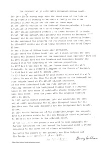
Card - Amateur Radio Cards, 1929
... . Brown of 23 Mackay Crescent South Warrnambool (call sign... Crescent South Warrnambool (call sign unknown). No information has ...These two cards have been sent In 1929 by two early Warrnambool amateur radio persons to William (Bill) Douglas, an amateur radio person with the call sign, VK3GA. The cards are QSL cards, sent as a result of radio contacts being made between two amateur radio persons. Bill Douglas (1898-1986) was a Victorian schoolteacher who was the first licensed amateur radio person in the Otway Ranges district. He was licensed in January 1929 and these cards refer to radio contacts in the July of that year. The cards do not feature the call signs of the contacts but were standard cards used by amateur radio people who did not have personalised cards at the time,. One card was sent by J.F. Anderson (VK3WN) whose address at the time was 100 Foster Street, Warrnambool. He was possibly connected to the family of James and Jane Anderson who lived for some time in Foster Street but later went farming in the Nullawarre district. The other card was sent by W. Brown of 23 Mackay Crescent South Warrnambool (call sign unknown). No information has been found on this person.These two cards are of some importance as they are very early examples of amateur radio operations in Warrnambool. .1 A rectangular card, very faded and torn at edges. The card has a red border and red and black printing and handwritten material. On the back is a handwritten letter. .2 A rectangular card, very faded and torn at the edges. The card has a red border and black and red printing and handwritten material. On the back are a postal franking stamp, a green postage stamp and a handwritten address.1 a handwritten letter .2 Radio VK3GA Lavers Hill Victoriaamateur radio stations, w. douglas vk3ga, j.f.anderson vk3wn, w.brown warrnambool -
 Surrey Hills Historical Society Collection
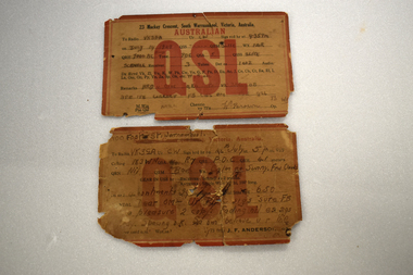
Work on paper - Digital photograph, George L Coop, Surrey Hills railway station c1958, c1958
... (part of only). A number of the Edwardian houses along the south.... It is also significant as a record of the housing along the south ...The donor George Lister Coop was about 21 years of age when he took this photo. It is one of a small series of photos donated by him that relate to Mont Albert and Surrey Hills stations. He has always had an interest in railways and there are other examples of his documentation of railway history in other collections contributing to this database. R J Mercer was the butcher at 112 Union Road. This property has a long history of being a butcher's shop beginning from c1904. He took over from Edward Lloyd in 1951. Spotless Dry Cleaners were at 104 Union Road.This is an important photo as there are few known colour images of the station prior to the installation of the third line in the early 1970s, which resulted in the demolition of the station built in 1883. It is also significant as a record of the housing along the south side of Stirling Crescent which was later replaced by light industry.A digital colour photo of Surrey Hills railway station taken from the overhead pedestrian footbridge looking towards Canterbury. Both tracks and the verandas on either side of the line can be seen, as can the railway gates in the open position and the signal box, beside which is a large palm tree. A section of red goods vans are positioned in the adjacent goods yard. Some of the businesses and advertising hoardings in Union Road can be seen in the background. These include A Doubleday (real estate agents), R J Mer..., grocer, baker, Spotless Dry Cleaning, Robur tea and Lipton tea (part of only). A number of the Edwardian houses along the south side of Stirling Crescent are also seen.george l coop, surrey hills railway station, goods yard, real estate agent, a doubleday, grocer, baker, union road, stirling crescent, spotless dry cleaning, r j mercer, butcher -
 Eltham District Historical Society Inc
Photograph - Aerial Photograph, Landata, Eltham, Vic, Jan. 1951
Centred on Allison Crecent Reserve, Sherbrook Road and Scenic Crescent, Eltham bounded by Allendale Road to north, Dudley Street to south, Zig Zag Road to east and St Helena Road to west. Historic Aerial Imagery Source: Landata.vic.gov.au Aerial Photo Details: Project No :65 Project : MELBOURNE AND METROPOLITAN PROJECT NO. 2 Run : 7 Frame : 10 Date : 01/1951 Film Type : B/W Camera : EAG9 Flying Height : 12200 Scale : 12000 Film Number : 1419 GDA2020 : 37°42'14"S, 145°08'36"E MGA2020 : 336339, 5825416 (55) Melways : 21 H2 (ed. 42)Historical aerial photos and photo maps provide viusal evidence of the chronology of changes to the built landscape of the district and assist in dating other imagesaerial photo, 1951-01, eltham, neil webster collection, allendale road, allison crecent reserve, dudley street, melway 21h2, scenic crescent, sherbrook road, st helena road, zig zag road -
 Eltham District Historical Society Inc
Photograph - Aerial Photograph, Landata, Eltham North, Feb. 1956
Centred on present day 54 Kelway Crescent, Eltham North bounded by Glen Gully Road to north, Meruka Drive to south, Eltham College to east and Leach Street to west. Historic Aerial Imagery Source: Landata.vic.gov.au Aerial Photo Details: Project No :250 Project : MELBOURNE OUTER SUBURBS PROJECT Run : 17 Frame : 113 Date : 02/1956 Film Type : B/W Camera : EAG9 Flying Height : 10000 Scale : 12000 Film Number : 1176 GDA2020 : 37°42'16"S, 145°08'08"E MGA2020 : 335650, 5825336 (55) Melways : 21 G2 (ed. 42)aerial photo, 1956-02, eltham, eltham north, glen gully road, leach street, main road, melway 21g2, meruka drive, montmorency, neil webster collection -
 Eltham District Historical Society Inc
Photograph - Aerial Photograph, Landata, Eltham, Vic, Feb. 1956
Centred on present day Parsons Avenue at Leane Drive near the Maroondah Aqueduct, Eltham bounded by Lorimer Road to north, Thompson Crescent and Norman Road to south, Bells Hill Road to east and Parsons Road to west Historic Aerial Imagery Source: Landata.vic.gov.au Aerial Photo Details: Project No :250 Project : MELBOURNE OUTER SUBURBS PROJECT Run : 19 Frame : 5 Date : 02/1956 Film Type : B/W Camera : EAG9 Flying Height : 10000 Scale : 12000 Film Number : 1176 GDA2020 : 37°42'04"S, 145°11'09"E MGA2020 : 340064, 5825786 (55) Melways : 22 H1 (ed. 42)aerial photo, 1956-02, neil webster collection, allendale road, bells hill road, eltham, leane drive, lorimer road, maroondah aqueduct, melway 22h1, norman road, parsons road, research (vic.), thompson crescent -
 Eltham District Historical Society Inc
Photograph - Aerial Photograph, Landata, Research, Vic, Feb. 1956
Centred on present day Thompson Crescent, Research bounded by Maroondah Aqueduct to north, Thompson Crescent and Nyora Road to south, Bells Hill Road to east and Eucalyptus Road to west Historic Aerial Imagery Source: Landata.vic.gov.au Aerial Photo Details: Project No :250 Project : MELBOURNE OUTER SUBURBS PROJECT Run : 19 Frame : 6 Date : 02/1956 Film Type : B/W Camera : EAG9 Flying Height : 10000 Scale : 12000 Film Number : 1176 GDA2020 : 37°42'38"S, 145°11'02"E MGA2020 : 339927, 5824736 (55) Melways : 22 H4 (ed. 42)aerial photo, 1956-02, neil webster collection, bells hill road, eltham, eucalyptus road, maroondah aqueduct, melway 22h4, nyora road, research (vic.), thompson crescent -
 Eltham District Historical Society Inc
Photograph - Aerial Photograph, Landata, Eltham, Vic, Apr. 1963
Centred on present day Zig Zag Road and Main Road, Eltham bounded by Maroondah Aqueduct to north, Thompson Crescent and Arthur Street to south, Parsons Road to east and Glen Park Road and Banks Road to west. Historic Aerial Imagery Source: Landata.vic.gov.au Aerial Photo Details: Project No :486 Project : MELBOURNE (1963) PROJECT Run : 5 Frame : 59 Date : 04/1963 Film Type : B/W Camera : RC8 Flying Height : 5100 Scale : 9600 Film Number : 1805 GDA2020 : 37°42'24"S, 145°08'52"E MGA2020 : 336716, 5825114 (55) Melways : 21 J3 (ed. 42)aerial photo, neil webster collection, eltham, 1963-04, arthur street, banks road, glen park road, maroondah aqueduct, melway 21j3, parsons road -
 Eltham District Historical Society Inc
Photograph - Aerial Photograph, Landata, Eltham, Vic, Apr. 1963
Centred on present day Floriston Grove, Eltham bounded by Maroondah Aqueduct to north, Thompson Crescent and Diosma Road to south, Research Shops to east and Glen Park Road and Park West Road to west. Historic Aerial Imagery Source: Landata.vic.gov.au Aerial Photo Details: Project No :486 Project : MELBOURNE (1963) PROJECT Run : 5 Frame : 60 Date : 04/1963 Film Type : B/W Camera : RC8 Flying Height : 5100 Scale : 9600 Film Number : 1805 GDA2020 : 37°42'24"S, 145°09'29"E MGA2020 : 337622, 5825128 (55) Melways : 22 B3 (ed. 42)aerial photo, neil webster collection, eltham, 1963-04, diosma road, floriston grove, maroondah aqueduct, melway 22b3, park west road, research (vic.), research shops -
 Eltham District Historical Society Inc
Photograph - Aerial Photograph, Landata, Research, Vic, Apr. 1963
Centred on present day Thompson Crescent and Nicholson Close, Research bounded by Maroondah Aqueduct to north, Nyora Road to south, Eltham College to east and Eltham Gateway Hotel to west. Historic Aerial Imagery Source: Landata.vic.gov.au Aerial Photo Details: Project No :486 Project : MELBOURNE (1963) PROJECT Run : 5 Frame : 61 Date : 04/1963 Film Type : B/W Camera : RC8 Flying Height : 5100 Scale : 9600 Film Number : 1805 GDA2020 : 37°42'24"S, 145°10'06"E MGA2020 : 338528, 5825143 (55) Melways : 22 D3 (ed. 42)aerial photo, neil webster collection, eltham, 1963-04, eltham college, eltham gateway hotel and conference centre, maroondah aqueduct, melway 22d3, nicholson close, nyora road, research (vic.), thompson crescent -
 Eltham District Historical Society Inc
Photograph - Aerial Photograph, Landata, Eltham, Vic, Apr. 1972
Centred on present day Ryans Road at Sandra Avenue, Eltham bounded by Progress Road to north, Brougham Street to south, Bible Street to east and Outlook Crescent to west. Historic Aerial Imagery Source: Landata.vic.gov.au Aerial Photo Details: Project No :985 Project : MELBOURNE 1972 Run : 27 Frame : 48 Date : 04/1972 Film Type : B/W Camera : RC10 Flying Height : 5700 Scale : 9600 Film Number : 2636 GDA2020 : 37°42'41"S, 145°08'38"E MGA2020 : 336392, 5824574 (55) Melways : 21 H4 (ed. 42)aerial photo, neil webster collection, 1972-04, eltham, bible street, brougham steet, melway 21h4, outlook crescent, progress road, ryans road, sandra avenue, montmorency -
 Glen Eira Historical Society
Ephemera - St. Mary’s Church, Caulfield
Two copies from St. Mary’s Anglican Church Caulfield, orders of service to celebrate Victoria’s 150th anniversary April 28, 1985. Four copies of pamphlet from St. Mary’s Anglican Church, Caulfield for The Joys of Living in Victoria, a festival of flowers and music dated April 25-28 1985. Included is a brief history from the 1850’s to 1985 of the church. Official opening leaflet with details of events and sponsors. The Joys of Living in Victoria, a festival of flowers and music order of service. Roneoed copy dated 25/04/1985.st. mary’s anglican church, caulfield, brooks r.c. rev., glasson william, organists, glen eira road, allen s. m. and sons, furniture stores, kennington laundry and drycleaners, drycleaners, glen huntly road, elsternwick, nepean highway, gardenvale, caulfield south, t. bathursts and co., funeral directors, ricks camera shop, elsternwick furnishing co., rothels pty. ltd., the sausage factory, four corners picture framing co., taylors the discount store, eight st. georges road, reception rooms, mane event hairdressing, fiskens pharmacy, boyd w. fox chemist, elsternwick travel world, mahony denis, hairline 309, hairdressers, madge tulloch florist, florist shops, michelson and associates, estate agents, port phillips press pty. ltd., printing industry, sommers jill, caulfield city choir, choirs, the tait-smith chamber group, tudor choristers, cathedral brass ensemble, trumble joan, brookes raymond rev., porter miss, park street, stephen george sir, hood crescent, bluestone, reid mr., architects, macartney mrs., st. mary’s church, st. stephen’s, gardenvale, st. clement, elsternwick, st. agnes, glenhuntly, glen huntly, st. catherine, caulfield, langley canon, shelford, green bishop, schools, helenslea, caulfield grammar school, davis j.h. rev., house names -
 Eltham District Historical Society Inc
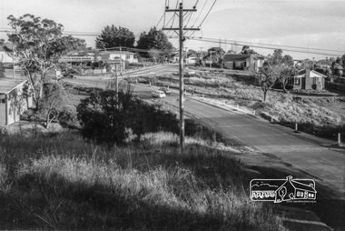
Photograph, Michael Wood, View south from 184 Progress Road to houses on Scenic Crescent, Eltham North, February 1970, 1970
Wood family home (1969-2011) pre and post construction by Knox and HellemonsKodachrome 35mm colour transparency in cardboard mount Processing date FEB70M6Inscribed in ink "View south from 184 Progress to Scenic Crescent, Eltham North 1970"alistair knox design, eltham north, hellemon, houses, progress road, scenic crescent -
 Eltham District Historical Society Inc
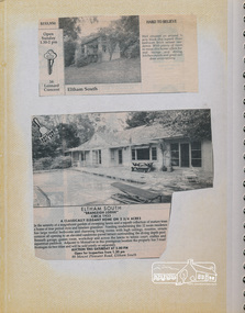
Newsclipping, 16 Leonard Crescent and Branleigh Lodge, 90 Mount Pleasant Road, Eltham South
Contained in Volume 1 of a set of two spiral magnetic photo albums, each containing 10 leaves, 20 pages; Vol. 1 labelled "Houses - Eltham South" and Vol. 2 labelled "Eltham Houses". Newspaper clippings advertising house auctionseltham, eltham south, real estate advertisement, houses, leonard crescent, mount pleasant road, branleigh lodge -
 Eltham District Historical Society Inc
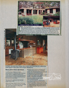
Newsclipping, Lalirra, 100 Scenic Crescent, Eltham, June 1989, 1989
Contained in Volume 2 of a set of two spiral magnetic photo albums, each containing 10 leaves, 20 pages; Vol. 1 labelled "Houses - Eltham South" and Vol. 2 labelled "Eltham Houses". Newspaper clippings promoting house auctioneltham, real estate advertisement, houses, lalirra, morrisons estate agent, scenic crescent -
 Eltham District Historical Society Inc
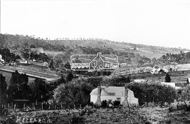
Photograph, Research, Vic
Research. House in centre foreground is same house as centre left Ref. 512. Looking about south-south west, down Research Gully Road. Source: Mrs. E.R. Reynolds, Thompson Crescent, ResearchThis photo forms part of a collection of photographs gathered by the Shire of Eltham for their centenary project book,"Pioneers and Painters: 100 years of the Shire of Eltham" by Alan Marshall (1971). The collection of over 500 images is held in partnership between Eltham District Historical Society and Yarra Plenty Regional Library (Eltham Library) and is now formally known as the 'The Shire of Eltham Pioneers Photograph Collection.' It is significant in being the first community sourced collection representing the places and people of the Shire's first one hundred years.Digital imagesepp, shire of eltham pioneers photograph collection, research (vic.) -
 Eltham District Historical Society Inc
Negative - Photograph, Tom Prior, Langlands Bridge, Eltham, c.1900
It is noted in the Reynolds Prior collection (Ivy Reynolds) as the first bridge in Eltham however given the current state of knowledge, this is considered unlikely and there is no other supporting source. John Hunter Langlands, owner of the farm known as ‘Ihurst’ on the west side of Diamond Creek to the south of John Wright Murray’s land, died in 1907. In 1909 his land was subdivided into 100 lots to become the ‘Glen Park Estate’. It is possible that the bidge may have crossed the Diamond Creek to Langland's land along the original alignment of Glen Park Road which used to run between present day Progress Road and Coleman Crescent. SEPP Source (c.1970): Mrs. E.R. Reynolds, Thompson Crescent, Research The Reynolds family were early settlers in Research. The Reynolds/ Prior collection of photographs were taken by Tom Prior, the maternal uncle of Ivy Reynolds, around 1900 and the 60 photos in the album give a fine overview of many of the landmarks of Research and Eltham over 100 years ago. lvy lived in the family home for many years at 106 Thompson Cres Research. Ivy's father, Ernst Richard Reynolds and grandfather, Richard Reynolds, lived at the same address. Ivy's father Richard worked for Mr. Trail on his property in Research. Reynolds Road is named after the family. Mr Tom Prior (wife Eva) worked at the Melbourne zoo. He was very innovative and made his own camera, using the black cloth hood to exclude the light. The photographs are a reminder of the rural nature of Research and Eltham and its rich heritage. This photo forms part of a collection of photographs gathered by the Shire of Eltham for their centenary project book,"Pioneers and Painters: 100 years of the Shire of Eltham" by Alan Marshall (1971). The collection of over 500 images is held in partnership between Eltham District Historical Society and Yarra Plenty Regional Library (Eltham Library) and is now formally known as the 'The Shire of Eltham Pioneers Photograph Collection.' It is significant in being the first community sourced collection representing the places and people of the Shire's first one hundred years.Digital image 4 x 5 inch B&W Neg B&W printsepp, shire of eltham pioneers photograph collection, eltham, langlands bridge, reynolds prior collection, bridge, john hunter langlands -
 Warrnambool and District Historical Society Inc.
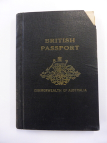
Document - Passport British Commonwealth of Australia, Australian Government, 1950s and 60s
This passport belonged to Alexander Swinton, a member of a prominent family in Warrnambool. The passport shows that he travelled extensively in Europe, U.S.A. and Central and South America. Alex Swinton’s forebears, William and Ann Swinton came to Warrnambool in 1854 and William Swinton opened a shop selling hardware, china and glassware in Timor Street Warrnambool in 1865. The Swinton businesses expanded in the 19th and 20th centuries and a Swinton furnishing store still exists today, making this store one of the oldest family businesses in Australia. Alexander Swinton (1907-1986) was the son of George and Florence Swinton of Merri Crescent Warrnambool. He attended Warrnambool Technical School in the early 1920s.This box is of interest as a memento of Alexander Swinton, a member of a prominent Warrnambool family. It also shows the type of passport issued to Australian citizens in the 1950s and 60s. These are two passport booklets joined together with white tape. Each has 32 pages and the booklet contains two black and white photographs, personal information (both printed and written), stamps and printed information from various countries and two inserted certificates. The front cover is black with printing and the image of the Australian Government crest.British Passport Commonwealth of Australiaalexander swinton, warrnambool, history of warrnambool, swinton, passport -
 Warrnambool and District Historical Society Inc.
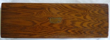
Functional object - Box Swinton Collection, Mid 20th century
This box comes from the Swinton collection and belonged to Alex Swinton. The Swinton family are a pioneering family in Warrnambool with William and Ann Swinton arriving in the town in 1854. Swinton businesses (stores selling furnishings, produce, hardware, clothing, glassware etc.) have been important in Timor Street, Warrnambool since 1865 and are among the oldest family businesses in Australia. Alexander Swinton (1907-1986) was the son of George and Florence Swinton of Merri Crescent Warrnambool. He attended Warrnambool Technical School in the early 1920s. This box is of minor interest as a memento of Alexander Swinton, a prominent member of a prominent Warrnambool family.This is a rectangular-shaped wooden box. It has a rough surface base suggesting that it once was covered in some type of cloth. The top and the sides have a brown varnished surface with a marbled finish. The remains of a metal plaque are in the centre of the top. The inside of the box suggests that it was originally padded to fit a particular object. The lid has two metal hinges and the two catches on the side are metal. Some lettering inside is encased in the outline of a shield and a triangle. Union Case …. Trade Mark H.Coward (or Goward) alexander swinton, warrnambool, history of warrnambool, swinton -
 Ringwood and District Historical Society
Flyer, Stillwell & Stephens Pty. Ltd, Brochure - Multiple Properties for Public Auction at Box Hill, Ringwood, Wonga Park and Clarinda - 28th November, 1934
Seven-page brochure advertising Mortgagees' Realising Sale by Public Auction on Wednesday, 28th November, 1934 for properties at Box Hill, Ringwood, Wonga Park, and Clarinda (via Oakleigh), including photographs, property descriptions, and terms of sale.Auction Commencing at 2.15 p.m. in the Orient Line Auction Rooms, 352 Collins Street, Melbourne. Solicitors: Messrs. Madden, Butler, Elder & Graham, 406 Collins Street, Melbourne. (Agents) H.P. Knight & Co. Property Salesmen and Subidivisional Experts, 315 Collins Street, Melbourne, 'Phones: Central 10615, 10616. Attractive Residential, Orchard, and Market Garden Properties, and Public Hall and School Rooms. 1. Wonga Park via Ringwood - "Holme Bush" off Warrandyte Road, Part of Lots 14 and 15, Ringwood Orchard Estate, approximatgely three miles (north) of Ringwood Railway Station - 64 Acres. 2. 17 Bishop Street, Box Hill - timber residence. 3. Greenwood Avenue, Ringwood - On East Side, 150 feet 3 inches South of Bedford Road - timber attic residence. 4. Ringwood - Wantirna Road, South-east corner of Canterbury Road - Orchard Property of approx. 11-1/2 Acres. 5. Box Hill - Whitehorse Road, South-east corner of Linsley Street - Timber building utilised as a Public Hall and Private School. 6. Clarinda vic Oakleigh, Talbot Crescent, off Centre Road - Home on 10 acres of land. -
 Eltham District Historical Society Inc
Photograph, Looking south along Para Road at intersection of Alma Street and Lees Road, Lower Plenty, c.July 1967, 1967
Old community hall (long wall with row of windows) and Lower Plenty Kindergarten visible at corner of Glenauburn and Para Roads. Packaged in "Filmpro King Size prints Definitely Better EST. 1918" envelope. Pencil notes: 36 shots $2.87 Eltham Shire J. McD and 19/7/67. Alma Street and Kett Street Lower Plenty c.July 1967.Black and white photographalma street, glenauburn road, carisbrook crescent, lees road, lower plenty, lower plenty kindergarten, para road, houses, streets