Showing 2792 items matching "south side"
-
 Ballaarat Mechanics' Institute (BMI Ballarat)
Bridge St South side
... Bridge St South side......South side...Ballarat Bridge St South side Bridge St South side ...This photograph is from the Max Harris Collection held by the Ballaraat Mechanics' Institute. Please contact BMI for all print and usage inquiries.ballarat, bridge st, south side -
 Glenelg Shire Council Cultural Collection
Negative - Glass Plate Negative - South side Julia Street Portland, 1890-1910
... Glass Plate Negative - South side Julia Street Portland...Glass plate negative. Image shows south side of Julia Street between Percy and Bentinck Streets Portland...Glenelg Shire Council Cultural Collection History House Cliff Street Portland great-ocean-road Glass plate negative. Image shows south side of Julia Street between Percy and Bentinck Streets Portland Negative Glass Plate Negative - South side Julia Street Portland ...Glass plate negative. Image shows south side of Julia Street between Percy and Bentinck Streets Portland -
Port Melbourne Historical & Preservation Society
Photograph - Ground work for new marina on south side of Yarra, Ron Laing, 1990s
... Ground work for new marina on south side of Yarra...A set of 26 colour photographs covering the ground work for the new marina on the south side of the river below the new harbour control tower...Donated to the PMH&PS by the photographer. yarra river built environment ron laing A set of 26 colour photographs covering the ground work for the new marina on the south side of the river below the new harbour control tower Photograph Ground work for new marina on south side of Yarra Ron Laing ...Part of Ron Laing's collection of photographs recording Port Melbourne over a thirteen year period. Donated to the PMH&PS by the photographer.A set of 26 colour photographs covering the ground work for the new marina on the south side of the river below the new harbour control toweryarra river, built environment, ron laing -
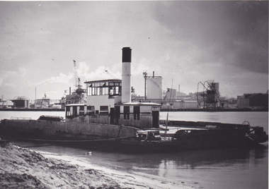 Port Melbourne Historical & Preservation Society
Photograph - Williamstown 'Short' Road ferry, laying at south side of the Yarra prior to being broken up, 1970s
... Williamstown 'Short' Road ferry, laying at south side of the Yarra prior to being broken up...Black and white photographic copy from slide of Short Road Ferry laying at south side of Yarra, prior to being broken up...Port Melbourne Historical & Preservation Society Port Melbourne Town Hall 333 Bay Street Port Melbourne melbourne transport - ferries Black and white photographic copy from slide of Short Road Ferry laying at south side of Yarra, prior to being broken up Photograph Williamstown 'Short' Road ferry, laying at south side of the Yarra prior to being broken up ...Black and white photographic copy from slide of Short Road Ferry laying at south side of Yarra, prior to being broken uptransport - ferries -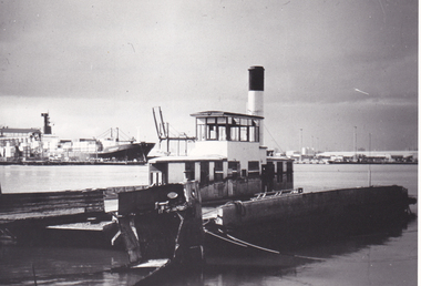
 Canterbury Primary School
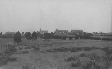
Photograph, South side of school
... South side of school...Black and white photograph showing the south side of school...Canterbury Primary School Molesworth Street Canterbury melbourne Black and white photograph showing the south side of school South side of school Photograph ...Black and white photograph showing the south side of school -
 Ringwood and District Historical Society
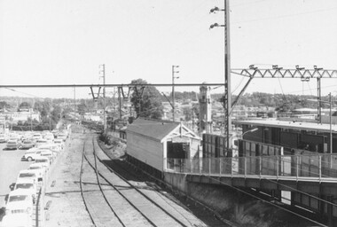
Photograph, Ringwood Railway Station - south side, 1973
... Ringwood Railway Station - south side, 1973....Written on back of photograph, "4-3-1973 - Ringwood Railway Station - south side"....Ringwood and District Historical Society 125A Warrandyte Road Ringwood North melbourne Written on back of photograph, "4-3-1973 - Ringwood Railway Station - south side". Black and white photograph Ringwood Railway Station - south side, 1973. ...Black and white photographWritten on back of photograph, "4-3-1973 - Ringwood Railway Station - south side". -
 Canterbury Primary School
Photograph, South side from Riversdale Road
... South side from Riversdale Road...Black and white photograph of south side of school taken from near Riversdale Road. ...South side from Riversdale Road Photograph ...Black and white photograph of south side of school taken from near Riversdale Road. -
 Ringwood and District Historical Society
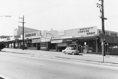
Photograph, Railway Station precinct shops, south side of Maroondah Highway, Ringwood - 1969
... Railway Station precinct shops, south side of Maroondah Highway, Ringwood - 1969...Image shows shops on south side of Maroondah Highway between railway station entrance and clocktower site at Wantirna Road....Black and white photograph Railway Station precinct shops, south side of Maroondah Highway, Ringwood - 1969 Photograph ...Black and white photograph Image shows shops on south side of Maroondah Highway between railway station entrance and clocktower site at Wantirna Road. -
 Canterbury Primary School
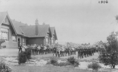
Photograph, South side of school
... South side of school...Black and white photograph showing south side of school with students lined up. Taken in 1916...Canterbury Primary School Molesworth Street Canterbury melbourne Black and white photograph showing south side of school with students lined up. Taken in 1916 South side of school Photograph ...Black and white photograph showing south side of school with students lined up. Taken in 1916 -
 Ringwood and District Historical Society
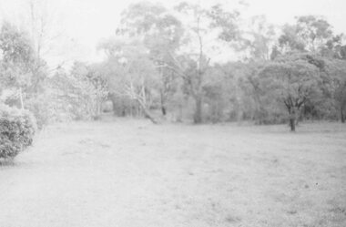
Photograph, Freeway site. Virgin bush. Ringwood Street looking west along south side Mullum Creek. Ringwood Late 1980
... Ringwood Street looking west along south side Mullum Creek. Ringwood Late 1980...Ringwood Street looking west along south side Mullum Creek."...Ringwood Street looking west along south side Mullum Creek." Freeway site. Virgin bush. ...Written on back of photograph, "Late '80. Freeway site. Virgin bush. Ringwood Street looking west along south side Mullum Creek." -
 Whitehorse Historical Society Inc.
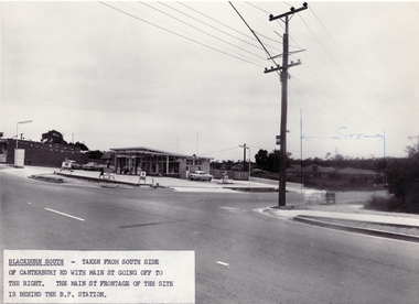
Photograph - Black and white photo, South side of Canterbury Road, Blackburn South, 9/11/1962 12:00:00 AM
... South side of Canterbury Road, Blackburn South....Black and white photo taken from South side of Canterbury Road with Main Street going off to the right. ...Blackburn South. South side of Canterbury Road, Blackburn South. ...Black and white photo taken from South side of Canterbury Road with Main Street going off to the right. Blackburn South.blackburn fibrous plaster works, industries -
 Charlton Golden Grains Museum Inc
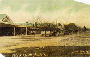
Postcard, High St. Charlton, South Side, c.1907
... High St. Charlton, South Side....Shows High St Charlton on the south side looking west. Includes Foundry and residence, man unloading a cart. ...Writing at the bottom of the card reads High St. Charlton, South Side. High St. Charlton, South Side. Postcard Postcard ...Charlton Foundry 1907 owned and operated by Dabrons. Had 20-30 employees.Copy of hand coloured post card. Shows High St Charlton on the south side looking west. Includes Foundry and residence, man unloading a cart. Another wagon is in front slightly down the street. Road is unpaved. One of a set of postcards taken in 1907. Writing at the bottom of the card reads High St. Charlton, South Side.dabron, charlton, foundry, high street, business, industry -
Federation University Historical Collection
Document, City of Ballarat - Building Permit for Grant Street, South Side, East of Armstrong Street
... City of Ballarat - Building Permit for Grant Street, South Side, East of Armstrong Street...Pale blue/green A4 document - City of Ballarat - Building Permit for Grant Street, South Side, East of Armstrong Street issued to the School of Mines Ballarart...Menhennet Building Permit Recreation Building Number stamp on top right hand corner Pale blue/green A4 document - City of Ballarat - Building Permit for Grant Street, South Side, East of Armstrong Street issued to the School of Mines Ballarart City of Ballarat - Building Permit for Grant Street, South Side, East of Armstrong Street Document ...School of Mines Ballarat, is a predecessor of Federation UniversityPale blue/green A4 document - City of Ballarat - Building Permit for Grant Street, South Side, East of Armstrong Street issued to the School of Mines BallarartNumber stamp on top right hand corner city of ballarat, ballarat school of mines, the ballarat school of mines and industries, j.b. menhennet, building permit, recreation building -
 Ringwood and District Historical Society
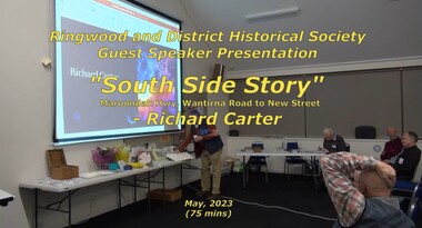
Mixed media - Video, RDHS Guest Speaker Presentation - "South Side Story - Maroondah Hwy, Wantirna Road to New Street" - Richard Carter
... RDHS Guest Speaker Presentation - "South Side Story - Maroondah Hwy, Wantirna Road to New Street" - Richard Carter...Presenter: Past-President of RDHS, Richard Carter, is the guru when it comes to researching properties. South Side Story examines the often forgotten - but important - part of Ringwood from Wantirna Road to Olive Grove on the southern side of Maroondah Highway, Ringwood, Victoria....Recorded May, 2023 (Video is available for viewing at Ringwood & District Historical Society Archives by appointment) RDHS Guest Speaker Presentation - "South Side Story - Maroondah Hwy, Wantirna Road to New Street" - Richard Carter Mixed media Video ...Digitised video (3.19GB) Duration: 75 minutes. Recorded May, 2023 (Video is available for viewing at Ringwood & District Historical Society Archives by appointment)Presenter: Past-President of RDHS, Richard Carter, is the guru when it comes to researching properties. South Side Story examines the often forgotten - but important - part of Ringwood from Wantirna Road to Olive Grove on the southern side of Maroondah Highway, Ringwood, Victoria. -
 Charlton Golden Grains Museum Inc
Photograph, Weekly Times, High St Charlton (south side) January 1929, January 1929
... High St Charlton (south side) January 1929...Copy taken from the Weekly Times, January 1929. South side of High Street, Charlton. Shows the Massey Harris Garage, Ike Richards Hairdressers, Procter's Butchers and Wylies Store. ...High St Charlton (south side) January 1929 Photograph Photograph Weekly Times ...Copy taken from the Weekly Times, January 1929. South side of High Street, Charlton. Shows the Massey Harris Garage, Ike Richards Hairdressers, Procter's Butchers and Wylies Store. Photo published in Weekly Times January 1929 as part of a Charlton storyBlack and white photo of High St Charlton looking west. One car driving toward photographer, petrol bowser on LH side, two parked cars on RH side. Ike Richards Ladies & Gents Hairdresser sign on building.massey harris, ike richards, procter, wylie, charlton, high street, wylie's building -
 Stawell Historical Society Inc
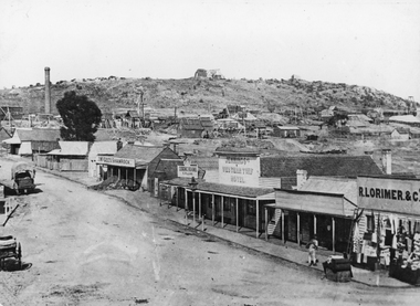
Photograph, Streetscape of South side of Upper Main Street Reefs Stawell looking East from around Patrick Street corner with Big Hill Mining in background c 1867
... Streetscape of South side of Upper Main Street Reefs Stawell looking East from around Patrick Street corner with Big Hill Mining in background c 1867...Streetscape of South Side of Main Street East of Patrick Street. ...Stawell Streetscape Streetscape of South Side of Main Street East of Patrick Street. ...Upper Main Street east of Patrick street, looking East c 1867 with Big Hill Mining in Background. J McGee's Shamrock Hotel. Jennings Western Turf Hotel. R Lorimer & Co. Photo c 1867 McGees Shamrock Hotel centre. R. Williams Dining Rooms,. Jennings's Western Turf Hotel situated in upper Main Street (Opposite Monaghan's Estate Office) Mr. George Jennings was proprietor until the late 1860's when he went to live at "Mayo Park" Lubek. The Hotel had Various owners until it was delicensed in 1909 and became a boarding house. It was demolished in 1921. R. Lorimer & Co general Store near corner of Patrick Street.Streetscape of South Side of Main Street East of Patrick Street. Two wagons in street. Showing J. McGees Shamrock Hotel, R Williams Dining Rooms, Jennings's Western Turf Hotel and R. Lorimer & Co. Mine Engine Chimney is on left of photo. Big Hill in Background with Waterloo Reef Company Whim at centre.stawell streetscape -
 Ballarat Tramway Museum
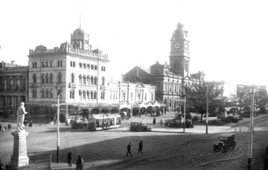
Photograph - digital Images, Sovereign Hill and Gold Museum, Sebastopol type tram travelling on the south side of Sturt St at the Lydiard St intersection, 2014
... Sebastopol type tram travelling on the south side of Sturt St at the Lydiard St intersection....Image from a printed sepia toned postcard of a Sebastopol type tram travelling on the south side of Sturt St at the Lydiard St intersection. ...Sebastopol type tram travelling on the south side of Sturt St at the Lydiard St intersection. ...Copy of an image and associated text for reference purposes only. Original document held by Sovereign Hill and Gold Museum. See the related document file for more details of holdings. The Museum does not hold the original of the document. Image from a printed sepia toned postcard of a Sebastopol type tram travelling on the south side of Sturt St at the Lydiard St intersection. Photo mid 1930's, has a taxi waiting at the median strip with other cars in the photograph as well. In the background is the Town Hall and National Mutual buildings. The statue of Robert Burns is on the left hand side of the image. The original postcard might give the tram number. Note the keywords given in the document file are incorrect.trams, tramways, sturt st, sebastopol type, lydiard st, taxis -
 Canterbury History Group
Photograph - Canterbury Mansions garden, south side of Maling Road, Jan Pigot, 27/03/1993 12:00:00 AM
... Canterbury Mansions garden, south side of Maling Road....Canterbury Maling Road Shops Trees Stables Streetscapes Gardens Signs Photograph Canterbury Mansions garden, south side of Maling Road. Jan Pigot ...canterbury, maling road, shops, trees, stables, streetscapes, gardens, signs -
 Canterbury History Group
Photograph - Streetscape of shops on the south side of Maling Road, Jan Pigot, 27/03/1993 12:00:00 AM
... Streetscape of shops on the south side of Maling Road...Canterbury Maling Road Shops Signs Wunderlite ceiling Photograph Streetscape of shops on the south side of Maling Road Jan Pigot ...canterbury, maling road, shops, signs, wunderlite ceiling -
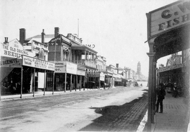
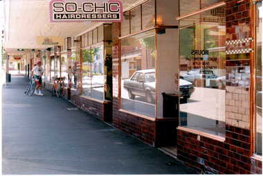
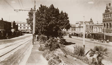
 Ballaarat Mechanics' Institute (BMI Ballarat)
South Side Sturt st 1947
... South Side Sturt st 1947...Ballarat Sturt town hall mechanics institute cars South Side Sturt st 1947 ...This photograph is from the Max Harris Collection held by the Ballaraat Mechanics' Institute. Please contact BMI for all print and usage inquiries.ballarat, sturt, town hall, mechanics institute, cars -
 Ballaarat Mechanics' Institute (BMI Ballarat)
South Side Sturt st 1947
... South Side Sturt st 1947...Ballarat Sturt 1947 South Side Sturt st 1947 ...This photograph is from the Max Harris Collection held by the Ballaraat Mechanics' Institute. Please contact BMI for all print and usage inquiries.ballarat, sturt, 1947 -
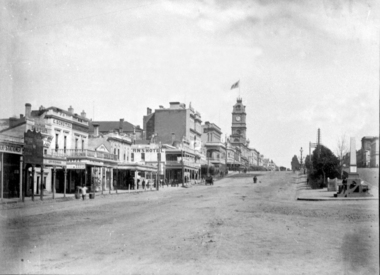 Ballaarat Mechanics' Institute (BMI Ballarat)
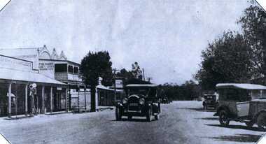
Looking up Sturt St South side
... Looking up Sturt St South side...Ballarat sturt st Looking up Sturt St South side ...This photograph is from the Max Harris Collection held by the Ballaraat Mechanics' Institute. Please contact BMI for all print and usage inquiries.ballarat, sturt st -
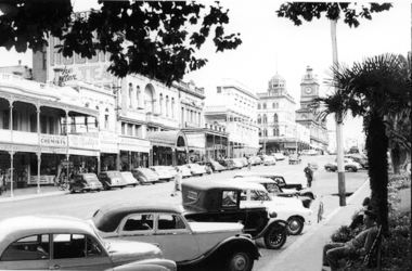
 Ballaarat Mechanics' Institute (BMI Ballarat)
Looking up Sturt st south side 1960's
... Looking up Sturt st south side 1960's...Ballarat sturt st 1960's Mechanics Institute Town Hall Unicorn hotel Vegas cinema Looking up Sturt st south side 1960's ...This photograph is from the Max Harris Collection held by the Ballaraat Mechanics' Institute. Please contact BMI for all print and usage inquiries.ballarat, sturt st, 1960's, mechanics institute, town hall, unicorn hotel, vegas cinema -
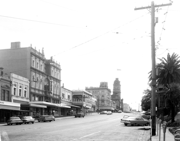
 Ballaarat Mechanics' Institute (BMI Ballarat)
South Side Sturt St Looking toward Grenville St
... South Side Sturt St Looking toward Grenville St...Ballarat sturt st grenville st South Side Sturt St Looking toward Grenville St ...This photograph is from the Max Harris Collection held by the Ballaraat Mechanics' Institute. Please contact BMI for all print and usage inquiries.ballarat, sturt st, grenville st -
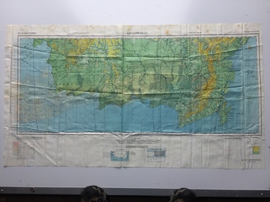 B-24 Liberator Memorial Restoration Australia Inc
Map - US World War II multi-coloured map, Side 1 - No. C-47 South Borneo, Side 2 - No. C-48 West Java, 1944
... US World War II multi-coloured map, Side 1 - No. C-47 South Borneo, Side 2 - No. C-48 West Java...AAF Cloth Chart Side 1 - No. C-47 South Borneo Side 2 - No. C.48 West Java...C-47 South Borneo, Side 2 - No. C-48 West Java ...Silk and rayon maps were produced by the United States (c. 7.5 million in total), Great Britain (some 1.75 million in total) and Australia during World War II. They were issued to Allied military personnel as part of 'escape and evasion' kits.This map, printed on acetate rayon, is an original US 'escape and evasion' kit map from World War II.A multi-coloured, contoured, double-sided map printed on acetate rayon AAF Cloth Chart Side 1 - No. C-47 South Borneo Side 2 - No. C.48 West Javaunited states of america, silk and rayon maps, world war ii, a191 -
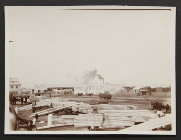 Mission to Seafarers Victoria
Photograph - Photograph, Sepia, Mr and Mrs Gurney Goldsmith, Landing lumber on the South Side of the Yarra - On the Wharf, 1906
... Landing lumber on the South Side of the Yarra - On the Wharf...Mission to Seafarers Victoria 717 Flinders Street Docklands melbourne james henty & co docks lumber timber wood wharf Yarra river Written in pencil on verso "12" Small monochrome photograph, lightly faded depicting lumber on the wharf with the James Henty and Co store in the background Landing lumber on the South Side of the Yarra - On the Wharf Photograph Photograph, Sepia Mr and Mrs Gurney Goldsmith ...Small monochrome photograph, lightly faded depicting lumber on the wharf with the James Henty and Co store in the backgroundWritten in pencil on verso "12"james henty & co, docks, lumber, timber, wood, wharf, yarra river -
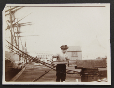 Mission to Seafarers Victoria
Photograph - Photograph, Sepia, Mr and Mrs Gurney Goldsmith, Landing lumber on the South Side of the Yarra - Apprentice measuring wood, 1906
... Landing lumber on the South Side of the Yarra - Apprentice measuring wood...Mission to Seafarers Victoria 717 Flinders Street Docklands melbourne Dockside photograph of young man loading/measuring wood apprentice wood lumber timber wharf yarra river Written in pencil on verso "12" Small monochrome photograph depicting an apprentice on the wharf holding planks of wood Landing lumber on the South Side of the Yarra - Apprentice measuring wood Photograph Photograph, Sepia Mr and Mrs Gurney Goldsmith ...Dockside photograph of young man loading/measuring wood Small monochrome photograph depicting an apprentice on the wharf holding planks of woodWritten in pencil on verso "12"apprentice, wood, lumber, timber, wharf, yarra river -
 Eltham District Historical Society Inc
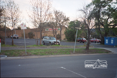
Photograph, Margaret Ball, Carpark, south side of Pryor Street, Eltham, June 1999, 1999
... Carpark, south side of Pryor Street, Eltham, June 1999...Not all of the houses could be photographed; some because the garden or trees blocked the view of the house, others because of rubbish or cars were in the way, some because people were working on the house or in the gardens at the time. eltham houses streets margaret ball (pre 1960s houses) collection pryor street safeway store carparks Fuji 200 Roll of 35mm colour negative film, 10 strips Carpark, south side of Pryor Street, Eltham, June 1999 Photograph Margaret Ball ...Original Safeway store, demolished July 2000The Margaret Ball (Pre 1960s Houses) Collection was a personal project initiated to mark the year 2000 and arose as a result of the disappearance of many pre-1960s parts of Eltham due to development. Approximately 200 pre-1960s style houses that were left in Eltham between Main Road and east to Bible Street, between Cecil Street to the north and south to Dalton Street were photographed in late 1999. Not all of the houses could be photographed; some because the garden or trees blocked the view of the house, others because of rubbish or cars were in the way, some because people were working on the house or in the gardens at the time.Roll of 35mm colour negative film, 10 stripsFuji 200eltham, houses, streets, margaret ball (pre 1960s houses) collection, pryor street, safeway store, carparks -
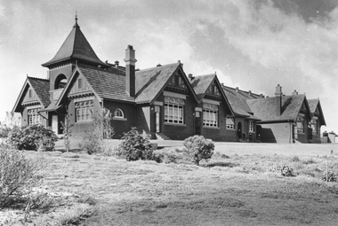
 Eltham District Historical Society Inc
Photograph, South side of the house looking east towards brick storage shed, Eltham Living and Learning Centre
... South side of the house looking east towards brick storage shed, Eltham Living and Learning Centre...Eltham District Historical Society Inc 728 Main Rd Eltham melbourne eltham living and learning centre Black and white photograph South side of the house looking east towards brick storage shed, Eltham Living and Learning Centre Photograph ...Black and white photographeltham living and learning centre