
Showing 50 items matching "southeast corner"
-
 Eltham District Historical Society Inc
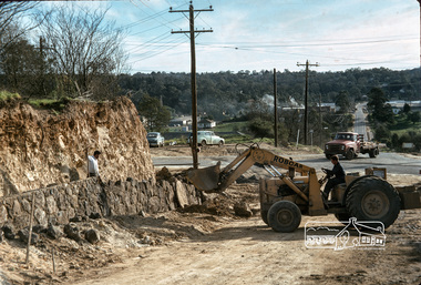
Photograph, Fred Mitchell, New embankment on southeast corner of Bridge Street and Main Road, Eltham, during duplication works, 1968, 1968
... New embankment on southeast corner of Bridge Street and Main Road, Eltham, during duplication works, 1968...Roadworks for duplication of Main Road. fred mitchell collection 1968 eltham bridge street main road road construction duplication Digital copy of colour photograph New embankment on southeast corner of Bridge Street and Main Road, Eltham, during duplication works, 1968 Photograph Fred Mitchell ...Roadworks for duplication of Main Road.Digital copy of colour photographfred mitchell collection, 1968, eltham, bridge street, main road, road construction, duplication -
 Eltham District Historical Society Inc
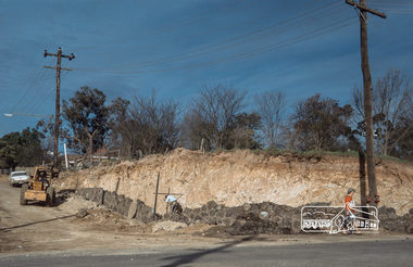
Photograph, Fred Mitchell, New embankment on southeast corner of Bridge Street and Main Road, Eltham, during duplication works, 1968, 1968
... New embankment on southeast corner of Bridge Street and Main Road, Eltham, during duplication works, 1968...Roadworks for duplication of Main Road. fred mitchell collection 1968 eltham bridge street main road road construction duplication Digital copy of colour photograph New embankment on southeast corner of Bridge Street and Main Road, Eltham, during duplication works, 1968 Photograph Fred Mitchell ...Roadworks for duplication of Main Road.Digital copy of colour photographfred mitchell collection, 1968, eltham, bridge street, main road, road construction, duplication -
 Eltham District Historical Society Inc
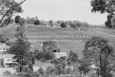
Photograph, Barry Philp, Second Hand store at the southeast corner of Reynolds Road and Main Road, Eltham, c.1969
... Second Hand store at the southeast corner of Reynolds Road and Main Road, Eltham...Reynolds Road Second Hand Dealer Victorian Bushfires - 1969 Eltham Eltham-Yarra Glen Road Digital copy only Second Hand store at the southeast corner of Reynolds Road and Main Road, Eltham Photograph Photograph Barry Philp ...Corner of Reynolds Road. The store is on the left, the house on the right was the home of the Dodkins family (Phographer Barry Philp's uncle and aunty). The house on the hill was Philbrick's home which burnt out in the bush fires.bushfires, dodkins family home, fire damage - buildings, main road, philbrick family home, research (vic.), reynolds road, second hand dealer, victorian bushfires - 1969, eltham, eltham-yarra glen road -
 Melbourne Tram Museum
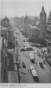
Postcard - Swanston St Town Hall, V S M, c1910
... ...southeast corner...The north looking photograph was taken from a tall building around Flinders Lane. On the southeast corner of Swanston and Collins Sts it is possible to see the cable tramway signalman under his canopy as depicted in entry 9482. ...The north looking photograph was taken from a tall building around Flinders Lane. On the southeast corner of Swanston and Collins Sts it is possible to see the cable tramway signalman under his canopy as depicted in entry 9482. ...Postcard shows cable trams, horse drawn vehicles, the Town Hall and other building nearby, many pedestrians and shop fronts. The north looking photograph was taken from a tall building around Flinders Lane. On the southeast corner of Swanston and Collins Sts it is possible to see the cable tramway signalman under his canopy as depicted in entry 9482. Yields information about Melbourne Town Hall and Swanston StreetBlack and white postcard with title on front and message and stamp on rear.On front 'Swanston St Melbourne'; on rear Stamp postmarked; addressee 'Miss S Babbage 'Woodstock' Ocean Beach Manly Sydney'; message in closely written pen, much of which is illegible, about staying in St Kilda, enjoying the shopping and travelling to Daylesford. 'VSM series Postcard'. pedestrians, cable trams, horse drawn vehicles, town hall, shop fronts, southeast corner, cable tramway signalman -
 Port Melbourne Historical & Preservation Society
Photograph - Stairway and servery, GMH Social Centre, Fishermen's Bend, David Thompson, 1997
... From a series of black and white photos of GMH Social Centre by David Thompson: Southeast corner - stairway and servery...David Thompson photographed the Social Centre in 1997 by arrangement with member Wendy Morris archivist for GMH. industry - manufacturing built environment david thompson general motors-holden gmh From a series of black and white photos of GMH Social Centre by David Thompson: Southeast corner - stairway and servery Photograph Stairway and servery, GMH Social Centre, Fishermen's Bend David Thompson ...Murals: Eileen Robertson, a GMH employee, was asked to do the murals in 1948 for the launching of the Holden. Her brief was to 'do something to do with transport'. In the event, they were covered anyway. She did not even view them again until 1992, around the time the murals were cleaned and restored. The left mural shows pioneer transport and on the right is the future. David Thompson photographed the Social Centre in 1997 by arrangement with member Wendy Morris archivist for GMH.From a series of black and white photos of GMH Social Centre by David Thompson: Southeast corner - stairway and serveryindustry - manufacturing, built environment, david thompson, general motors-holden, gmh -
Port Melbourne Historical & Preservation Society
Photograph - Pioneer' mural, GMH Social Centre, Fishermen's Bend, David Thompson, 1997
... From a series of black and white photos of GMH Social Centre by David Thompson: Southeast corner of hall and 'Pioneer' mural...David Thompson photographed the Social Centre in 1997 by arrangement with member Wendy Morris archivist for GMH. industry - manufacturing built environment david thompson general motors-holden gmh From a series of black and white photos of GMH Social Centre by David Thompson: Southeast corner of hall and 'Pioneer' mural Photograph Pioneer' mural, GMH Social Centre, Fishermen's Bend David Thompson ...Murals: Eileen Robertson, a GMH employee, was asked to do the murals in 1948 for the launching of the Holden. Her brief was to 'do something to do with transport'. In the event, they were covered anyway. She did not even view them again until 1992, around the time the murals were cleaned and restored. The left mural shows pioneer transport and on the right is the future. David Thompson photographed the Social Centre in 1997 by arrangement with member Wendy Morris archivist for GMH.From a series of black and white photos of GMH Social Centre by David Thompson: Southeast corner of hall and 'Pioneer' muralindustry - manufacturing, built environment, david thompson, general motors-holden, gmh -
Port Melbourne Historical & Preservation Society
Photograph - Pioneer' mural (close up), GMH Social Centre, Fishermen's Bend, David Thompson, 1997
... From a series of black and white photos of GMH Social Centre by David Thompson: Southeast corner of hall and 'Pioneer' mural, close up...David Thompson photographed the Social Centre in 1997 by arrangement with member Wendy Morris archivist for GMH. industry - manufacturing built environment david thompson general motors-holden gmh From a series of black and white photos of GMH Social Centre by David Thompson: Southeast corner of hall and 'Pioneer' mural, close up Photograph Pioneer' mural (close up), GMH Social Centre, Fishermen's Bend David Thompson ...Murals: Eileen Robertson, a GMH employee, was asked to do the murals in 1948 for the launching of the Holden. Her brief was to 'do something to do with transport'. In the event, they were covered anyway. She did not even view them again until 1992, around the time the murals were cleaned and restored. The left mural shows pioneer transport and on the right is the future. David Thompson photographed the Social Centre in 1997 by arrangement with member Wendy Morris archivist for GMH.From a series of black and white photos of GMH Social Centre by David Thompson: Southeast corner of hall and 'Pioneer' mural, close upindustry - manufacturing, built environment, david thompson, general motors-holden, gmh -
 Kew Historical Society Inc
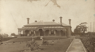
Photograph, Deepdene
... Photograph of the historically significant house, Deepdene, which was located before demolition on the southeast corner of Burke Road and Cotham Road. The photograph is on the back of a subdivision plan of the Auburn Heights Estate....Deepdene Photograph of the historically significant house, Deepdene, which was located before demolition on the southeast corner of Burke Road and Cotham Road. The photograph is on the back of a subdivision plan of the Auburn Heights Estate. ...Rare photograph of a significant Melbourne home.Photograph of the historically significant house, Deepdene, which was located before demolition on the southeast corner of Burke Road and Cotham Road. The photograph is on the back of a subdivision plan of the Auburn Heights Estate.deepdene -
 Eltham District Historical Society Inc
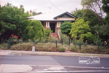
Photograph, Margaret Ball, 58 Bible Street, Eltham, Nov-Dec 1999, 1999
... Southeast corner of Bible and Bridge Streets. Owner 1930s-1950s: George and Grace Miller...Southeast corner of Bible and Bridge Streets. Owner 1930s-1950s: George and Grace Miller The Margaret Ball (Pre 1960s Houses) Collection was a personal project initiated to mark the year 2000 and arose as a result of the disappearance of many pre-1960s parts of Eltham due to development. ...Southeast corner of Bible and Bridge Streets. Owner 1930s-1950s: George and Grace MillerThe Margaret Ball (Pre 1960s Houses) Collection was a personal project initiated to mark the year 2000 and arose as a result of the disappearance of many pre-1960s parts of Eltham due to development. Approximately 200 pre-1960s style houses that were left in Eltham between Main Road and east to Bible Street, between Cecil Street to the north and south to Dalton Street were photographed in late 1999. Not all of the houses could be photographed; some because the garden or trees blocked the view of the house, others because of rubbish or cars were in the way, some because people were working on the house or in the gardens at the time.Roll of 35mm colour negative film, 7 stripsKodak GC 400-6eltham, houses, streets, margaret ball (pre 1960s houses) collection, bible street -
Tarnagulla History Archive
Photograph - Photograph: Lowther and James at Tarnagulla, 1916
... View is from the southeast corner of Methodist Church with Union Bank and its chimney in background. ...View is from the southeast corner of Methodist Church with Union Bank and its chimney in background. ...Williams Family Collection. Photograph depicting Cormack Lowther and Sam James in 1916 cyaniding the Poverty Heap at Poverty Hill, Tarnagulla. View is from the southeast corner of Methodist Church with Union Bank and its chimney in background. Original photographic print. Above information handwritten on reverse.tarnagulla -
 Port Melbourne Historical & Preservation Society
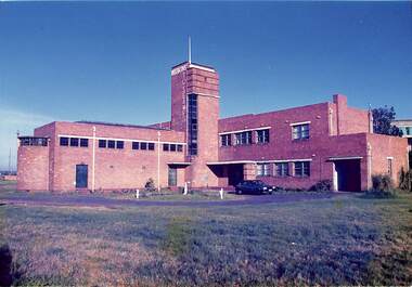
Photograph - Missions to Seamen, Port Melbourne, Alison Kelly, 1990
... Port Melbourne Missions to Seamen building, view from southeast corner of ground. Portion of Commonwealth Engine Works just visible at right, 1984 Ford Laser parked in circular driveway near front entrance. ...Photographed by Alison Kelly while she was joint caretaker of the building during the Mission Arts Centre days 1987 to 1991 missions to seamen built environment Port Melbourne Missions to Seamen building, view from southeast corner of ground. Portion of Commonwealth Engine Works just visible at right, 1984 Ford Laser parked in circular driveway near front entrance. ...Photographed by Alison Kelly while she was joint caretaker of the building during the Mission Arts Centre days 1987 to 1991 Port Melbourne Missions to Seamen building, view from southeast corner of ground. Portion of Commonwealth Engine Works just visible at right, 1984 Ford Laser parked in circular driveway near front entrance. From album of photos mostly by Alison Kelly:missions to seamen, built environment -
 Kew Historical Society Inc
Photograph - Former Kew Police Station : Wall and chimney, 1996
... View through the Cotham Road carpark towards High Street of the southeast corner of the former police station. The use of red brick, tall brick chimneys and slate roof were representative of the Queen Ann Style used in the construction of the Kew Public Offices in 1888....They are historically and architecturally significant to the State of Victoria because Watson and Harvey's designs exhibit diversity in integrating civil offices, they accommodate the apex of road junctions, and they demonstrate a departure from the contemporaneously favoured High Victorian Classical to the Queen Anne style in the design of civic buildings. public offices -- kew (vic) kew police station View through the Cotham Road carpark towards High Street of the southeast corner of the former police station. The use of red brick, tall brick chimneys and slate roof were representative of the Queen Ann Style used in the construction of the Kew Public Offices in 1888. ...A civic campaign for new public offices developed in Kew in the 1880s. After much deliberation, the location chosen was the junction of Bulleen and Cotham Roads. The buildings were designed by George Watson and John Henry Harvey, architects within the Department of Public Works (Victoria). Building was commenced in 1887, and after one year, the buildings were opened. The Post Office was transferred to the new Commonwealth Government in 1901. The Police Station and Court House, sold by the Victorian Government to the City of Boroondara in 2007, are now a community cultural centre and performing arts venue.The buildings were listed on the Victorian Heritage Register Register (HO885) in 1991. They are historically and architecturally significant to the State of Victoria because Watson and Harvey's designs exhibit diversity in integrating civil offices, they accommodate the apex of road junctions, and they demonstrate a departure from the contemporaneously favoured High Victorian Classical to the Queen Anne style in the design of civic buildings.View through the Cotham Road carpark towards High Street of the southeast corner of the former police station. The use of red brick, tall brick chimneys and slate roof were representative of the Queen Ann Style used in the construction of the Kew Public Offices in 1888.public offices -- kew (vic), kew police station -
 Melbourne Tram Museum
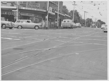
Photograph - Malvern Road and Glenferrie Road intersection, 1960s
... Photograph of Malvern Road and Glenferrie Road intersection showing the tram track H crossing with dual turnouts on the southwest and southeast corners. The tram tracks are at a lower level than bitumen roadway causing a rough undulating surface for motor vehicles. ...Photograph of Malvern Road and Glenferrie Road intersection showing the tram track H crossing with dual turnouts on the southwest and southeast corners. The tram tracks are at a lower level than bitumen roadway causing a rough undulating surface for motor vehicles. ...Photograph of Malvern Road and Glenferrie Road intersection showing the tram track H crossing with dual turnouts on the southwest and southeast corners. The tram tracks are at a lower level than bitumen roadway causing a rough undulating surface for motor vehicles. Extra works lighting is hanging from the overhead on one side of the junction suggesting future night works. This junction would eventually be relaid in mass concrete. A milk bar advertising various ice creams and other small shops are located at the intersection. Yields information about deterioration of tramway tracks and need for maintenance or replacement. Black and white photograph with no notemalvern road, glenferrie road, junction, works lighting, milk bar, mass concrete -
 Eltham District Historical Society Inc
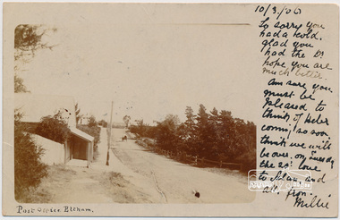
Postcard, Post Office, Eltham, 1906, 1906
... Watson's Hotel on southeast corner, Fountain Hotel on southwest corner and Morrison's house on the northwest corner. ...Watson's Hotel on southeast corner, Fountain Hotel on southwest corner and Morrison's house on the northwest corner. ...Postcard sent to Mrs W. Heber Green (Adelaide May Green), 10 March 1906 From Millie. William Heber Green was a lecturer according to the 1909 Electoral Roll. Looking south along Maria Street (Main Road) from intersection with Bridge Street, Eltham, c.1906. Burgoyn'e Post Office on left. The footpath was about 2 feet above the road level. Horse and cart near the entrance to John Street. Webster's house was on the the northeast corner of Pitt and Maria (Main Road) and the verandah was over the footpath. Watson's Hotel on southeast corner, Fountain Hotel on southwest corner and Morrison's house on the northwest corner. (Doug Orford) Used post card with notePostage stamp and post marked Eltham Victoriaadelaide may green, bridge street, burgoyne, eltham, fountain hotel, main road, maria street, millie, morrison home, pitt street, post office, watsons hotel, webster home, william heber green -
 Ballarat Tramway Museum
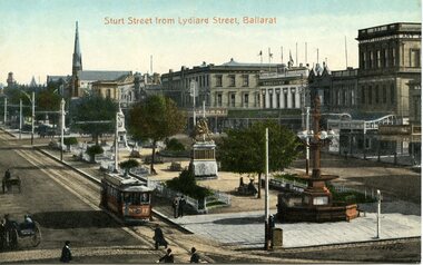
Postcard, Valentine & Sons Publishing Co, Sturt Street from Lydiard St Ballarat, c1912
... Printed colour postcard of the intersection of Sturt St. looking west from the southeast corner of Lydiard St. In the bottom left-hand corner is the number "300479" and the initials "JV"? ...Printed colour postcard of the intersection of Sturt St. looking west from the southeast corner of Lydiard St. In the bottom left-hand corner is the number "300479" and the initials "JV"? ...Printed colour postcard of the intersection of Sturt St. looking west from the southeast corner of Lydiard St. In the bottom left-hand corner is the number "300479" and the initials "JV"? within a circle. In the view are Crockers and the Art Gallery Association buildings. The later became the SEC Ballarat city offices. Image possibly taken c1912 as the trams appear to have driver's windows. Car featured in photo is No. 17. Note on the position of the rear lifeguard area of the tram is the word "Summerscales". Titled "Sturt St from Lydiard St Ballarat" centrally along the top of the card. The printer/publisher of the card is "The Valentine & Sons Publishing Co. Ltd, Melbourne and Sydney". In the stamp area is the number "20-2". Two copies held. Yields information about Ballarat and Sturt St in c1912Postcard - coloured, divided back, Valentine & SonsOn rear in ink "No. 17 old type, about 1912", Ken Magor stamp and letters "WJ" underneath.trams, tramways, esco, sturt st, postcards, lydiard st, tram 17 -
 Kew Historical Society Inc
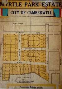
Plan - Subdivision Plan, Myrtle Park Estate, City of Camberwell, 1916
... The Park adjoined the southeast corner of the new subdivision. The Estate included 74 regular allotments characterised by narrow frontages and long blocks. ...The Park adjoined the southeast corner of the new subdivision. The Estate included 74 regular allotments characterised by narrow frontages and long blocks. ...The Kew Historical Society collection includes almost 100 subdivision plans pertaining to suburbs of the City of Melbourne. Most of these are of Kew, Kew East or Studley Park, although a smaller number are plans of Camberwell, Deepdene, Balwyn and Hawthorn. It is believed that the majority of the plans were gifted to the Society by persons connected with the real estate firm - J. R. Mathers and McMillan, 136 Cotham Road, Kew. The Plans in the collection are rarely in pristine form, being working plans on which the agent would write notes and record lots sold and the prices of these. The subdivision plans are historically significant examples of the growth of urban Melbourne from the beginning of the 20th Century up until the 1980s. A number of the plans are double-sided and often include a photograph on the reverse. A number of the latter are by noted photographers such as J.E. Barnes.The ‘Myrtle Park Estate’ was a subdivision bounded by Victoria Road (now Lansdowne Street), Buchanan Avenue and Dight Avenue. Other streets that were created by the subdivision included Eurolie Street, Boorahman Street and Moody Street (now Sylvan Street). The Estate took its name from Myrtle Park (later changed to Macleay Park), which had been created in 1923 by Camberwell Council. The Park adjoined the southeast corner of the new subdivision. The Estate included 74 regular allotments characterised by narrow frontages and long blocks. Confusion may have greeted prospective purchasers as the Estate was advertised in the daily newspapers as being in East Kew, rather than in Camberwell, where it was at that stage located.subdivision plans - balwyn, myrtle park estate - camberwell [surrey hills] -
 Melbourne Tram Museum
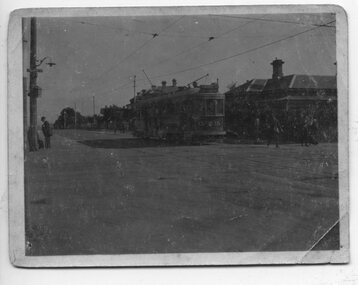
Photograph - HTT Tram 15 at Glenferrie and Riversdale Roads 1916-1920
... The donor's family operated the Purvis Real Estate on the southeast corner from the building now known as Stotts Corner. ...The donor's family operated the Purvis Real Estate on the southeast corner from the building now known as Stotts Corner. ...Photograph shows Hawthorn Tramways Trust bogie Tram 15 at Glenferrie and Riversdale Roads 1916-1920. The tram body was built by Duncan and Fraser of Adelaide and entered service during April 1916. It was renumbered N class 121 by the Melbourne and Metropolitan Tramways Board following the absorption of the Trusts by the MMTB in 1920. The tram is eastbound in Riversdale Road. The tracks of the Prahran and Malvern Tramway Trust can be seen in front of the tram. The conductor has alighted from the tram and walked forward to check for trams on Glenferrie Road. A Fire Brigade street fire alarm can be seen on the corner. The existing connecting curves at the corner were installed in 1925. The tramcar had a number of significant accidents and was disposed of in March 1938. Understood from the donor, that the house on the corner was known as "Pax" and demolished when commercial development of the corner occurred. The donor's family operated the Purvis Real Estate on the southeast corner from the building now known as Stotts Corner. A Golden Fleece service station once operated from the SW corner, now (2022) an Oportunity shop.Yields information about the intersection of Riversdale and Glenferrie Roads Hawthorn, the trams that operated between 1916 and 1920 and tramway practices in having the conductor checking for trams on the adjacent road.Sepia toned or faded print of Hawthorn Tramways Trust tram No. 15 at the corner of Riversdale Road and Glenferrie Road, Hawthorn - first image is a greyscale scan of original image.trams, tramways, hawthorn, riversdale road, glenferrie road, hawthorn tramways trust, tram 15, htt, stotts corner, purvis real estate -
 Eltham District Historical Society Inc
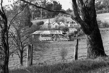
Photograph, George Coop, Carrucan's Dairy on Dalton Street, Eltham, c.1969, 1969
... Dalton Street runs from left to right between the dairy and the Carrucan family home opposite located on the southeast corner of Bible and Dalton streets. Doug Orford recalls the dairy was at a slight angle to Dalton Street. ...Dalton Street runs from left to right between the dairy and the Carrucan family home opposite located on the southeast corner of Bible and Dalton streets. Doug Orford recalls the dairy was at a slight angle to Dalton Street. ...Viewed from intersection of Mount Pleasant Road and Metery Road looking northwest. The dairy is in the foreground situated on Dalton Street. An unmade Bible Street can be seen running down the hill at the left to intersect with Dalton Street. Dalton Street runs from left to right between the dairy and the Carrucan family home opposite located on the southeast corner of Bible and Dalton streets. Doug Orford recalls the dairy was at a slight angle to Dalton Street. Tim Erickson, (a nephew to Betty Erickson, nee Carrucan) reacalled (9 May 2025): the bottom front paddock ran from MeteryRoad to Mount Pleasant Road The brick dairy from 1thje 1950s had 10-15 milking cow , Jersey and Guernsey6 and the used to send the cream to Eltham Dairy The garage when Tim was a child used to house a couple of sulkies The laundry was a local home built job The small house built late 1940s for Betty Carrucan for her family The small orchard grew Quince, Apple and Plum The main block was the upper paddock Cypress trees remain present as of 2025 Originally 2 buildings but a third was added in the early 1900s for a kitchen and diningDigital TIFF file Scan of 35mm Ilford HP4 black and white transparencybible street, carrucan dairy, carrucan home, dalton street, eltham, mount pleasant road -
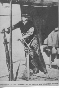 Melbourne Tram Museum
Photograph - Signalman at Collins and Swanton Streets, 1910s
... The canopy was located on the footpath on the southeast corner of the intersection of Collins and Swanston Streets. ...The canopy was located on the footpath on the southeast corner of the intersection of Collins and Swanston Streets. ...Photograph shows uniformed MTOC signalman standing under a canopy operating two large levers (which may be the reason the newspaper mistakenly described him as a switchman). He stands under a canopy supported by poles with a partial curtain at the rear along with his overcoat. The canopy was located on the footpath on the southeast corner of the intersection of Collins and Swanston Streets. This was the busiest cable tramway intersection in Melbourne and one of the busiest for pedestrian and vehicle traffic. The tram tracks crossed each other at right angles with no curved tracks to permit turns. The signalman's job was twofold: to directed which trams had right of way by use of mechanical signals and to depress the Collins Street cable so that the upward incline did not cause the cable to rise out of the slot onto the roadway. The depression gear was located under both Collins Street tracks adjacent to the Town Hall and was only released momentarily to allow a Collins Street tram to pass over it. This was a demanding job requiring constant vigilance: working with the policeman controlling the intersection, trams approaching from four directions, horse and motor traffic and pedestrians. The signalman's rules provided a specific order of steps each time the signals and depression gear were reset, which occurred many times per hour. He was also authorised to stop trams with the use of his whistle and a red hand lamp and to report gripmen who disobey his directions. Traffic lights were gradually introduced to Melbourne from 1928 after cable trams were replaced in Swanston Street and just before they were replaced in Collins Street. This is a photograph taken of a newsprint photograph from an unnamed newspaper. Yields information about signalman's work. Black and white photograph with note below photograph. Printed below photograph: "Switchman [sic] at the intersection of Collins and Swanston Streets."newsprint, mtoc, switchman, canopy, levers, collins street, swanston street, busiest intersection, traffic lights, 1928, policeman, signalman, mechanical signals, right of way, depression gear, twon hall, slot, vigilance -
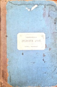 Wodonga & District Historical Society Inc
Document - House Creek School 2266 Inspector's Register Book 1881 - 1905
... The District Inspector approved and Albert Schlink offered two acres of freehold land as a site, four chains from the southeast corner of Allotment Eight, Section 10, of the Parish of Wodonga in the County of Bogong. ...The District Inspector approved and Albert Schlink offered two acres of freehold land as a site, four chains from the southeast corner of Allotment Eight, Section 10, of the Parish of Wodonga in the County of Bogong. ...This folder contains the official Inspector's reports for House Creek School Number 2266. Inspections were carried out every six months for all Victorian Government Schools. On 8th October 1879 Mathew Parnaby and others applied for the establishment of a school, between Huon and House Creeks, about four miles southwest of Wodonga. The District Inspector approved and Albert Schlink offered two acres of freehold land as a site, four chains from the southeast corner of Allotment Eight, Section 10, of the Parish of Wodonga in the County of Bogong. A portable classroom, 22ft x14ft, with quarters was erected at a total cost of £192, and SS2266 opened on 1st of June 1880 with Edwin Davis as Head Teacher. In 1883 the average attendance ranged between 12 and 20. Both school and quarters fell into a very bad state of repair. Temporarily closed in 1894, the school reopened as a result of a petition by Ferdinand Godde and others. By 1902 the school had a nett enrolment of 37, the grounds had been fenced, and a shelter shed erected by local effort. By 1907 the nett enrolment had risen to 45 with an average attendance of 37. Ferdinand V. Godde served as Correspondent of the Committee in 1911. House Creek was unstaffed in February 1917 and closed on 8th of November 1917. It reopened on 4th August 1921, but with a nett enrolment of 6, closed on the 24th July 1926. The building was sold for removal. Many of the reports in this Register were written and signed by Henry Finch Rix. He was a pioneer of the Victorian School Inspection System and from 1884 to 1887 worked as a Chief Inspector in the Beechworth Education District. He had previously played with the Carlton Football Club for one season. Henry Rix was a highly regarded educator and a staunch advocate of the establishment of school libraries to teach children of "the rich stores of profitable pleasure to be found in books."This item is significant because it documents progress and recommendations for students at an early government primary school in the Wodonga district.A large bound folder of printed forms. The majority have been completed in handwritten reports including names, notes and statistics. On cover: INSPECTOR'S REGISTER BOOK STATE SCHOOLShenry finch rix, house creek school, victorian school inspectors, school 2266 -
Kew Historical Society Inc
Plan - Burke Road Junction Estate, East Kew, 1940
... These include the petrol station and the dairy on the southeast and southwest corners of Burke Road and High Street/Doncaster Road. ...These include the petrol station and the dairy on the southeast and southwest corners of Burke Road and High Street/Doncaster Road. ...Subdivision plans and real estate flyers/brochures reveal a number of aspects of urban development and history. The Kew Historical Society's collection of these plans, as well as advertisements extracted from magazines, cover key aspects of community development and architectural history of Kew and Kew Eat as well as surrounding suburbs. While most of the plans in the collection were gifted to the Society by the former City of Kew, a number of other plans and advertisements have been donated by individuals, of which this is an example.Original 4-page bifold brochure advertising the Burke Road Junction Estate in Kew East. Advertised for sale in 1940, the estate comprised 16 'Central Allotments' fronting High Street, Kilby Road, and Glass Street. Pages 1 & 4, the front and back covers, includes a panoramic photograph of the junction which features a number of shops still extant, but also with buildings long demolished and redeveloped. These include the petrol station and the dairy on the southeast and southwest corners of Burke Road and High Street/Doncaster Road. The dairy includes a statue of a cow on its roof. Pages 2 & 3 include a detailed plan of the estate. subdivisions -- kew east (vic.), burke road junction estate -
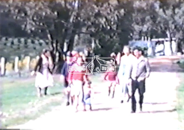 Eltham District Historical Society Inc
Film - Video (DVD), Frank Stokes, Stokes Family, 1950-1977
... Various family scenes taken from outside the family home on the southeast corner of the intersection of Nyora Road and Pitt Street with Eucalyptus Road. ...Various family scenes taken from outside the family home on the southeast corner of the intersection of Nyora Road and Pitt Street with Eucalyptus Road. ...Various family scenes taken from outside the family home on the southeast corner of the intersection of Nyora Road and Pitt Street with Eucalyptus Road. Also, scenes of the Stokes Orchard and equipment used, construction of water reservoir at the end of Nyora Road near Reynolds Road and Diosma Road as well as early stages of the Stokes Orchard housing development. Frank Stokes worked as a qualified accountant at Kennons leather factory in Burnley, while living at 1 Thomas Street, Mitcham. He suffered from migraines and wanted to go back to the land (he had previously worked on farms and orchards since coming to Australia in 1926 both in WA and Vic.). He first travelled to the district by train in July 1942 to find land with the intention to establish an orchard. By chance he met Arthur Bird of Bird Orchard (bounded by Pitt Street, Eucalyptus Road and Wattle Grove) and they got talking over their common interest. Arthur put Frank up for the night and pointed out the land, 158 acres- Taylor Estate- £900, part of Crown Allotment 15, Section 5, Parish of Nillumbik (CA15) somewhat diagonally opposite Bird Orchard. He applied through the Riverina Agency to purchase the land who in turn had to get permission from Canberra to sell as there was a new government regulation banning land sales except for immediate production. He obtained a loan on his Mitcham house of £600 @ 5% and paid £450 deposit with quarterly payments of £15 over 5 years. The title to the property was issued May 15, 1946. He was helped and advised by Arthur Bird who farmed the neighbouring orchard. Early 1943 he took possession and would catch the train out to Eltham on Fridays after work and began building a hut for shelter and to lock up tools. He was able to pay a neighbour (Hawkins) to help with clearing and fencing 25 acres and with a horse and single furrowed plow, planted approximately 2,500 fruit trees - cherries, peaches, plums, almonds, pears, apricots and lemons as well as a few apples and oranges; a massive job. A huge problem was hares and rabbits eating all the new buds off the tiny trees. As well as laying poison he painted the trees with a mixture of cow manure and lime. Often working by moonlight. It was extremely difficult to get wire and wire netting because of the war but after much effort he obtained a permit from the Agricultural Department for supplies in March 1944. In February 1945 he applied for a permit to build a “packing shed” as no house building allowed. It was to be 33 feet x 21 feet and cost £312. Constructed mostly from second-hand materials, which was hard to obtain, especially iron for roofing. Frank finished work at Kennons October 31, 1945, and in March 1946 he sold the Mitcham house for £1230 plus £170 for furniture. The family of five then moved into a very unfinished at Eltham, which was a struggle to weatherproof. Eventually rooms were divided off and lined with hessian bags and whitewashed. Their income was firewood (cut and sold), selling rockery stones and cut sweet bursaria. (It was discovered during the 1940s that Bursaria contained the sunscreen compound Aesculin. The RAAF utilised this compound from Bursaria during WW2 for pilots and gunners.) The orchard’s first fruit sale was a 1/2 case of Le Vanq peaches in December 1947 - 8 shillings. In 1956 plans for house were drawn and Glen Iris bricks purchased (1956 Olympic Rings variant). The building of the house commenced in 1957 - 12 feet of original packing shed removed – and was completed in 1959. Water was connected from newly built pressure storage on the property at the end of 1959 and the electricity connection for the first time at 3pm on April 29, 1960. In the mid-1970s the Shire of Eltham divided the orchard up into numerous rate-able parcel lots, which became unaffordable for Frank. Consequently, Stokes Orchard was turned into a housing development by Macquarie Builders and marketed as the Stokes Orchard Estate in two stages; Stage 1 encompassing Scarlet Ash Court, Ironbark Close and Peppermint Grove bounded by Nyora and Eucalyptus roads c.1976 and Stage 2 encompassing Stokes Place, Orchard Way, The Crest and The Lookout bound by Nyora and Diosma roads c.1979. The development of Orchard Way, The Crest and The Lookout did not proceed as planned due to the lack of the sewer along Diosma Road and so many of the proposed lots were incorporated into five-acre parcels instead. With the arrival of the sewer along Diosma Road many years later, most of these five-acre parcels have since been subdivided many times.Representative of the orchard growing areas of ElthamMP4 00:24:39; 426MB Digital file only - Digitised by EDHS from a DVD copy on loan from Beryl Bradbury (nee Stokes), daughter of Frank Stokes. 24 min duration compilation of home movie Super 8mm film shot by Frank Stokes brother-in-law.beryl bradbury (nee stokes) collection, frank stokes, nyora road, stokes orchard, stokes orchard estate, stokes place, video recording -
 Flagstaff Hill Maritime Museum and Village
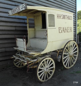
Vehicle - Wagon, H.H. Smith & Co. Baker, Circa 1930s - 1940s
... THE BAKERY PREMISES: – Southeast corner of Fairy and Lava Streets, Warrnambool. ...THE BAKERY PREMISES: – Southeast corner of Fairy and Lava Streets, Warrnambool. ...This baker’s wagon or cart transported and delivered bread and other baked goods in the Warrnambool area. It currently has advertising for H.H. Smith & Co. Henry Huntington Smith (1857-1941) owned and operated his Warrnambool bakery in the late 19th and early 20th century. However, the design of the wagon is similar to those used by local bakers in the 1930s and 1940s and probably originated from Stephenson’s Bakery in Warrnambool, which operated around that time. The wagon’s original internal shelves were removed in the early days of Flagstaff Hill so that children could have rides around the village in a horse-driven cart. BAKERS’ HISTORY There were many bakeries in Warrnambool in the 19th to mid-20th century. Each bread bakery made horse and cart deliveries in its allocated zone. SMITH’S BAKERY; – as shown on the wagon’s signage. Henry Huntington Smith (1857-1941) was born and educated in Warrnambool. He worked at Davis’ steam biscuit factory in Timor Street before he began his own bakery business in 1885 near the corner of Fairy and Koroit Streets. A few years later Smith built a new bakery on the corner of Fairy and Lava Street where it still stands today (2025) as Monaghan’s Pharmacy. The building was designed by James McLeod in 1892 as a bakehouse, shop and residence for Smith The address was known locally as Smith’s Corner. Next door to the bakery, at 136 Fairy Street, were stables built by Jobbins and McLeod in 1886 for William Cust. A photograph in the archives of the Warrnambool and District Historical Society shows the 1892 building with four fancy horse-drawn wagons on the street with white-clad drivers and a promotional stand erected with 5 bakers in uniform and the signage “H H Smith & Co, Pastry Cooks and Confectioners”. One of the wagons appears to have “H H Smith” painted on the side. H.H. Smith & Co. placed an Advertisement in the Weekly Times in December 1896 promoting its business as bakers, confectioners and pastry cooks, praising their shop as an ‘ornament to the town’ with ‘neat appointments’ and ‘dainty decorations’. It also boasted of supplying a large number of customers within a twelve-mile radius of Warrnambool. In November 1919 The Warrnambool Standard announced the marriage of Henry H Smith, Mayor of Warrnambool, to Jeannie Samson-Goodman in East Adelaide. In the same newspaper was a notice that Frank Crossley was to open as baker and pastry cook in H.H. Smith’s premises. As well as being the proprietor of the H.H. Smith Bakery, Henry Huntington Smith was a Councillor for the Warrnambool Municipality from 1913 to 1937 and Mayer for two terms. In December 1919 during his first term as Mayor, he was honoured for the work he had done with returning soldiers after World War I, receiving a document in recognition of this work, presented by the Mothers, Wives and Sisters of returned soldiers. Smith was very interested and involved in the community in many roles, including being the Vice President of the first Warrnambool and District Historical Society. STEPHENSON’S BAKERY: – believed to be the past owner of the wagon. The last owner of the bakery was Harold Stephenson. Stephenson was enlisted in the A.I.F. and was invalided home in 1943 before the end of the Second World War. He also served as a Councillor from 1958 to 1976, during which time he served six terms as Mayor for the City of Warrnambool (1966-1973) while he had the bakery. He was very involved in many local organisations including the Warrnambool Surf Life Saving Club and the Road Race Committee. He died in 1985, lauded as being one of Warrnambool’s “most distinguished civic leaders”. It has been said that the baker injured in World War II invented a special contraption to enable him to get up into the wagon and that he alerted his customers that he was in their vicinity by blowing a whistle. The customers would come out and choose their bread from the back of his wagon then pay him for it. However, another account is given by a man who once earned pocket money by helping the baker on his rounds. He says that it was Stephenson, the owner and manager of the bakery, and not the delivery baker who received a significant injury during the war, making him unable to climb the stairs of his upstairs accommodation at the bakery, therefore causing him to sleep downstairs. At this time in the early to late 1940 Stephenson’s bakery had three wagons, one for each of the delivery rounds. The wagons were painted black and yellow. Two of the drivers were Stan Lake and Ali (Alec) Dean who both had wagons with the covered cabin design. The third driver was Bill Lake who had a flat wagon. Stan Lake delivered in the area around Lava and Koroit Streets, Ali Dean had another round and Bill Lake had the Dennington area. Bread continued to be delivered into the 1960s but by this time the delivery vehicles were motorised. The goods produced at Stephenson’s bakery included bread baked in different shaped tins such as High Tin, Sandwich and Vienna. Some shapes were easily divided into half by breaking them apart, therefore the baker could make two-quarter loaves from a half loaf, satisfying different needs. There was the option of white or brown bread, sweet buns, fruit buns and Boston buns. The baker’s assistant was known to take great delight in ‘trimming’ the broken halves of excess bread and crust, enjoying his treat. THE BAKERY PREMISES: – Southeast corner of Fairy and Lava Streets, Warrnambool. The building retains the original cast iron veranda. Above the veranda, a motif of a wheat sheaf in ornamental plaster can be seen. Inside the building, there are still some of the original fittings. The building was classified by the National Trust in August 1979. After the Second World War, an official system of zoning was introduced as a fair way for the baking industry to operate. In 1949 different pricing was introduced by the Government for either delivered or retail purchased bread. Many of the small local bakeries went out of business after the Government banned zoning. The way was made open for the larger bread manufacturers to enter the local market with cheaper prices. Some of those companies were Mc Queens, Tip Top, Twisties, and Sunicrust, (Mc Queens ‘new’ bakery building was where the current Toyworld shop now stands, is, in the Ozone carpark.) O’Grady’s Bakery, later changing hands and known as Burkes Bakery, was on Fairy Street near the Timor Street intersection, on the North West side. There was also a bakery named Almay. The baker’s wagon is significant because of its association with H.H. Smith’s Bakery in Warrnambool.. The H.H. Smith’s Bakery building on the corner of Fairy and Lava Streets, built in 1892, is classified by the National Trust, August 1979. Smith Street Warrnambool was named after Henry Huntington Smith, who was a Warrnambool Councillor 1913 – 1937 and Mayor 1919 – 1921. Baker’s wagon, often referred to as a baker’s cart. Four wheeled horse-drawn delivery wagon, front wheels smaller than rear wheels. Wagon is clad with metal sheets and lined with varnished timber panels. Wheels have metal rims, wooden spokes and rear wheels have wooden brake pads. Horse shaft is timber with metal fittings. Front has a metal lamp holder, brake lever, metal hand grips and decorative metal foot plates. The wagon has suspension leaves on back and sides and double suspension leaves on the front. Driver’s area at front has a roof, glass side windows and wooden box seat with hinged compartment accessing wagon storage area. Door above back of seat has buckled leather handgrip strap attached, door slides open for access to wagon area. Back of wagon has a wooden step and a split door; top door has ventilation louvers, both doors have metal latches. Wagon is painted cream with brown trim and signage and green step. Remnants of red and green paint are visible; underside of seat panel is painted grey. Wagon advertises H.H. Smith & Co. Baker, a Warrnambool business established in 1885, but is of a more modern design seen around 1930’s and 1940’s and most likely belonging to Stephenson's bakery. Brown signwriting on sides of wagon “H.R. SMITH & CO. / BAKER” Brown signwriting across front of wagon “BAKER” warrnambool, shipwrecked-coast, flagstaff-hill, flagstaff-hill-maritime-museum, maritime-museum, shipwreck-coast, flagstaff-hill-maritime-village, shipwrecked-artefact, great ocean road, baker’s wagon, h.h. smith baker, warrnambool, henry h smith, jeannie samson-goodman, frank crossley, mayor of city of warrnambool, vice president of warrnambool and district historical society, stephenson’s bakery warrnambool, harold stephenson, warrnambool surf life saving club, road race committee, national trust building, stan lake, bill lake, ali dean, 19th and 20th century bakers, davies steam biscuit factory warrnambool, james mcleod building designer, jobbins and mcleod, william cust, h h smith & co, pastry cooks and confectioners, bakery trade, bread delivery wagon -
 Eltham District Historical Society Inc
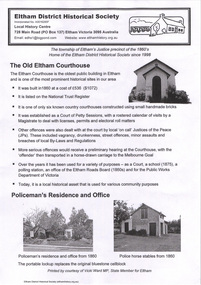
Document - Binder, Eltham Justice Precinct, 1969-2020
... Also includes notes (1963) on Lots 4 and 5 southeast corner of Main Road and Brougham Street owned by James Wallace Graham, Contractor, and Elsie May Graham. 2. ...Also includes notes (1963) on Lots 4 and 5 southeast corner of Main Road and Brougham Street owned by James Wallace Graham, Contractor, and Elsie May Graham. 2. ...EDHS_04863 - Binder: Eltham Justice Precinct Report: Conservation Management Plan (draft) for Justice Precinct Eltham, 5 August 2005; prepared for Nillumbik Shire by Ivar Nelsen and Janette Hodgson, Land Stewardship and Biodiversity - Historic Places, Department of Sustainability and Environment 1. Courthouse 1. Eltham Courthouse interesting facts i. Photocopy (2 pages) of extract from Petty Sessions at Eltham before C.S. Strutt Esq., Chairman; and (indecipherable) on the 12th day of September 1871; Case numbers 117 to 127. Details listed include Complainant, Defendant, Fees, Cause, Decision, Remarks. Defendants listed include Edward Bettison and John McCall, N.J. Keylock [Kaylock], Patrick Clark, Michael Keenan, Ann Hayden, Henry Edelman, Alexander Falkiner, Charles Long, Joseph Morris, Daniel Ryan ii. Photocopy (2 pages) of list of Convictions for surnames commencing with ‘B’ from 23 December 1890 to December 1905. 2. Plan and elevation drawings 3. Other courthouse plans and fittings 1880s – Brunswick, Maffra, Dunolly , Sunbury, Landsborough and Wodonga 4. Newspaper articles: i. ELTHAM POLICE COURT. (1892, April 1). Evelyn Observer, and South and East Bourke Record (Vic. : 1882 - 1902), p. 2 (MORNING.). Retrieved July 5, 2022, from http://nla.gov.au/nla.news-article60667022 ii. BREAKING A PUBLICAN'S LEG. (1900, July 13). Evelyn Observer, and South and East Bourke Record (Vic. : 1882 - 1902), p. 2 (MORNING.). Retrieved July 5, 2022, from http://nla.gov.au/nla.news-article60688367 iii. ELTHAM COURT. (1901, March 1). Mercury and Weekly Courier (Vic. : 1878 - 1903), p. 3. Retrieved July 5, 2022, from http://nla.gov.au/nla.news-article58578953 iv. ANNIE CHASES A TINKER. (1902, October 3). Evelyn Observer, and South and East Bourke Record (Vic. : 1882 - 1902), p. 2 (MORNING.). Retrieved July 5, 2022, from http://nla.gov.au/nla.news-article64029968 v. ELTHAM POLICE COURT. (1927, May 6). Advertiser (Hurstbridge, Vic. : 1922 - 1939), p. 4 (AFTERNOON). Retrieved July 5, 2022, from http://nla.gov.au/nla.news-article57754748 vi. ELTHAM POLICE COURT. (1927, May 20). Advertiser (Hurstbridge, Vic. : 1922 - 1939), p. 3 (AFTERNOON). Retrieved July 5, 2022, from http://nla.gov.au/nla.news-article57754814 vii. Eltham Police Court (1931, January 9). Advertiser (Hurstbridge, Vic. : 1922 - 1939), p. 4. Retrieved July 5, 2022, from http://nla.gov.au/nla.news-article56734073 viii. Repairs to Eltham Police Station, The Advertiser (1929, May 24). Advertiser (Hurstbridge, Vic. : 1922 - 1939), p. 2 (AFTERNOON.). Retrieved July 5, 2022, from http://nla.gov.au/nla.news-article57759907 ix. ELTHAM COURT. (1929, August 2). Advertiser (Hurstbridge, Vic. : 1922 - 1939), p. 4 (AFTERNOON.). Retrieved July 5, 2022, from http://nla.gov.au/nla.news-article57760345 x. See also Trove list https://trove.nla.gov.au/list/116634 5. Letter: Shire of Eltham Historical Society to Shire of Eltham, 1 July 1969 regarding potential replacement of Eltham Courthouse and the building’s historical significance and acknowledgement 10 July 1969 6. Letter: Shire of Eltham Historical Society to Law Department, 26 May 1972, re preservation of Eltham Courthouse and potential classification and acknowledgement 7 June 1972 7. Newspaper article: Strangers around, so Eltham sought protection by Marguerite Marshall, Diamond Valley News, Tuesday, April 6, 1982, p2 (On reverse side, Top job for our Pauline, p1) 8. Eltham Courthouse Colour Scheme, Public Works Department, 10 September 1983 9. Newspaper article: Eltham Courthouse under threat of closure by Helen Gillman, Diamond Valley News, October 16, 1984 10. Newspaper article: Courthouse to close by Helen Gillman, Diamond Valley News, Tuesday, November 20, 1984, p1 (also on p2 an article about Diamond Valley Shire festivities for the State’s 150th) 11. We will keep your court – Kennett, Diamond Valley News (probable), c.Dec. 1984 12. Letter: Shire of Eltham to Shire of Eltham Historical Society, 15 March 1985, regarding potential for use of building as a museum and reply dated 17 April 1985 regarding Society’s interest in use of the building 13. Letter: Department of Conservation Forests & Lands to Shire of Eltham, August 1987, regarding expressions of interest in the building and letter from Shire (18 August 1987) to Society advising of same 14. Letter: Department of Conservation Forests & Lands to Shire of Eltham, 30 March 1988, advising Courthouse to be used by Eltham Youth Resources Centre and the rear section by other community groups. Noted that the historical society was suggested by Council as a future user of the adjoining police residence when Council first sought management of the building and that should be investigated. Includes Schedule of Repair and Maintenance Work (4 pages), Existing Conditions Survey 30/7/1987 (6 pages) and 1 page plan view diagram 15. Memo: Historic Places Section to Eltham Youth Resource Centre re paint analysis of Courthouse, 17/5/1988, (6 pages) 16. Newspaper article: Courthouse renovation by Jodie Haythorne, Diamond Valley News, November 23, 1992 17. National Trust of Australia Registration (classified 20 Oct 1977), printed March 2000 18. Letter: Heritage Victoria 28 Feb 2002 regarding the replacement of the Courthouse Stand (Witness Box) 19. Article: There’s still order in this stately court house, Eltham Shire (magazine), date unk., p22-23 20. Eltham Court House, Statement of Significance, Heritage Victoria Register, printed Nov 2004 21. Eltham 1860 Former Court House 730 Main Road Eltham, collated by Eltham District Historical Society Incorporated 2005 (4 pages) 22. Book Extract: Eltham, Historical Court Houses of Victoria by Michael Challinger, Palisade Press, 2001 23. Newspaper article: Courthouse rich with history by Harry Gilham, Nillumbik Mail, c.2001 (see also EDHS_03333) 24. Notes on history of site from Crown Reserve File Rs 12128, Municipal Buildings (Local Community Welfare Reserve) at Eltham, Department of Sustainability and Environment, April 2005 (4 pages) 25. Newspaper article: Historic building upgrade, Diamond Valley Leader, August 3, 2005, p17 26. Newspaper article: Courthouse regeneration secures boost, Valley Weekly, August 10, 2005 with picture of Harry Gilham, Steve Herbert and Greg Johnson 27. Newspaper article: Poets are summonsed, Diamond Valley Leader February 22, 2006, p37 features picture of Helen Lucas at the Eltham Courthouse 28. Newspaper article: Sharing a love of legalities, Diamond Valley Leader, March 1, 2006, p7 features a picture of Rob Hulls and Steve Herbert talking to students in the courthouse 29. Newspaper advertisement: Nillumbik Tender No. 2021-33, Building Restoration Works, Old Eltham Courthouse, The Age, November 7, 2020 30. Form: Police Officer’s Return To A Warrant Of Distress 31. Handwritten notes: three pages listing all 48 of the pigeon hole form listings in the cabinet in the courthouse 32. Newspaper article: Historic Eltham Courthouse reopens, Manningham and Nillumbik Bulletin, April 2022, p22 33. Expression of Interest, Eltham Courthouse, 730 Main Road, Eltham; Nillumbik Shire Council Living and Learning Centres Eltham & Panton Hill, 8 May 2000 (Committee of Management) 2. Police Quarters 1. 1971 Surveyors Plan of 728 Main Road and the Adjoining Courthouse. Also includes notes (1963) on Lots 4 and 5 southeast corner of Main Road and Brougham Street owned by James Wallace Graham, Contractor, and Elsie May Graham. 2. Letter: Shire of Eltham to Shire of Eltham Historical Society, 5 June 1981, requesting the society give consideration to the suitability of the existing buildings (former Vermin and Noxious Weeds Office, Department of Crown Lands and Survey) for historical purposes such as a museum 3. Minutes: Shire of Eltham Historical Society Committee Meeting, 10 June 1981 (2 pages) includes reference to possible use of building as a museum (also reference to Bills Horse trough to be retained) 4. Extract from Victoria Police Gazette 1930 with details of building and site 5. Newspaper article: Cubby haven, Diamond Valley News, October 28, 1991 about replica Police Station with picture of replica along with Monika Roitinger and Garry Bartlett outside the Police Station 6. Environment office up for sale? Mountain Views, Monday, June 12, 1995 (Nillumbik Shire Council proposing to sell property. Did not proceed as ownership held by the State of Victoria) 7. Extract from National Trust February 1998 edition, “Police Rescue” which states Heidelberg and Eltham Police Residences are the oldest known Police Residences in the Melbourne Metropolitan district 8. Newspaper article: The first police office by Harry Gilham, Nillumbik Mail, December 13, 2000 (also photocopy with notations on picture identifying buildings and Harry’s typed draft) 9. Fax Memo: Victoria Police List of Officers in Charge, Eltham Police Station, 1857-1991 onward, 21 Jan 2003 10. Former Police Quarters, Statement of Significance, Heritage Victoria Register, printed Nov 2004 11. Eltham 1860 Former Police Quarters 728 Main Road Eltham, collated by Eltham District Historical Society Incorporated 2005 (5 pages) 12. Report: Eltham District Historical Society to Living and Learning Nillumbik, 14 April 2010 regarding the poor state of condition of the former Police Residence 13. Photocopy of three photos of the former Police Residence, former Police Station (relocated to rear of site) and Stables, October 18, 1991 3. Lockup 1. Newspaper article: Heritage permit bid, Diamond Valley News, January 17, 2001 (also article “Eltham library tops”) includes picture of lockup located in Youth Road 2. Newspaper article: Old lockup in new site, Diamond Valley Leader, March 21, 2001, p15. Includes picture of Harry Gilham with lockup at justice Precinct 3. Letter: Victoria Police to Eltham District Historical Society, 20 March 1991 including laser print photo of lockup in 1963 at 23 Pryor Street 4. Fax: Graham Clark, Associated Crane Trucks Pty Ltd, 833 Main Road Hurstbridge; Quote 26.2.99 for $1,080 to move lockup from Youth Road to 728 Main Road 4. Local History Centre 1. Victoria Government Gazette: Photocopy, No. 165, Tuesday, December 7, 1858, establishment of a Court of Petty Sessions at Eltham, 7 December 1858 2. Victoria Government Gazette: Photocopy, September 16, 1859, contract issued for Police buildings at Eltham to Langridge and Co., McCarter, Baillie, Nicol and Co, Chadley, Amos and Co., Cameron, Payne, £1,150.7.0 3. Victoria Government Gazette: Photocopy, October 2, 1860, contract issued for Court of Petty Sessions at Eltham to James Duncan, £600 4. President’s Report, Eltham District Historical Society, Annual General Meeting, Wednesday, March 11, 1998 – covers the establishment of the Local History Centre and new home for the Society 5. Extract for EDHS Newsletter July 1998 – Eltham Local History Centre – Official Opening 6. Unveiling of 728 Street Sign, Speech notes by Cr Dianne Bullen, December 2000, includes invoice from John Sharp Signs Pty Ltd, 24/10/2000 and planning approval drawing dated 24/3/1999 reproduced in Newsletter No. 135 November 2000 7. Letter: Eltham District Historical Society to Living and Learning Centre, undated draft regarding being a member of the committee reviewing the development of the site 8. Notes from Rod Grant re funding of site development under the Community Jobs Program 9. Letter: Eltham District Historical Society to Nillumbik Living and Learning, 28 October 2004 re inclusion of the Society in enhancing the site under the Community Jobs Program 10. Letter: Department of Sustainability and Environment to Eltham District Historical Society, 28 February 2005 re preparing draft Conservation Plan and copy of cover letter in response 2 April 2005 11. Levels and Layout Plan, Nillumbik Shire Council, September 2005, AO copy 12. Letter: Department of Sustainability and Environment to Eltham District Historical Society, 12 September 2005 re Eltham Justice Precinct Conservation Management Plan 13. Letter: Living and Learning Nillumbik, 2 February 2006 to Eltham District Historical Society re forming a Committee to advise on the use, maintenance, management and preservation of the Justice Precinct 14. Minutes: Meeting of a Task group to explore the establishment of a Committee to manage the Eltham Justice Precinct, 20 December 2005 (with hand written notes) 15. President’s notes (EDHS), General Meeting item, 11 May 2006 pertaining to use and condition of the Eltham Justice Precinct 16. Paint estimates, Old Eltham Court House, undated 17. Notes from meeting 26 September (2006), Eltham Justice Precinct Committee 18. Notes from meeting 27 November (2006), Eltham Justice Precinct Committee 19. Terms of Reference for the Eltham Justice Precinct Committee, Draft for Living and Learning Committee Meeting 24 Jan 2007 (4 pages) 20. Newspaper article: Panel set up, Diamond Valley Leader, 7 March 2007 21. Minutes: Meeting of Eltham Justice Precinct Subcommittee, 10 May 2007 22. Minutes: Meeting of Eltham Justice Precinct Subcommittee, 5 July 2007 23. Minutes: Meeting of Eltham Justice Precinct Subcommittee, 11 October 2007 24. Minutes: Meeting of Eltham Justice Precinct Subcommittee, 7 February 2008 25. Minutes: Meeting of Eltham Justice Precinct Subcommittee, 10 April 2008 26. Minutes: Meeting of Eltham Justice Precinct Subcommittee, 14 August 2008 27. Letter: EDHS (Sue Law) to Living and Learning, 6 September 2008 re proposed signage 28. Agenda: Meeting of Eltham Justice Precinct Subcommittee, 16 October 2008 29. Suggested guidelines for use of the Court House for exhibitions 30. Handwritten note re Ken Eckersal and Uniting Church of possible donation of church organ for sale, proceeds to be used for activities at the Justice precinct 31. One page typed notes on each of the buildings in the Eltham Justice Precinct 32. Newspaper article: Historic Eltham Courthouse reopens, Manningham and Nillumbik Bulletin, April 2022, p22 5. Miscellaneous 1. Photocopy from Pioneers & Painters (2 pages) covering the establishment of Police and Court of Petty Sessions at Eltham 2. Photocopy of photo looking northeast across Little Eltham buildings c.1910 with notes 3. Photocopy of J.H Clarke photo looking up Maria Street from near Dalton Street with notes identifying precinct buildings 4. Photocopy of photo of Court House and Police Quarters with cow outside from Heather Jenkins scrapbook with notes identifying buildings 5. Sketch and notes with dimensions for blue stone lockup including other miscellaneous handwritten notes 6. Unidentified heritage review details of Justice Precinct (c.2004) 7. Hand written notes of telephone conversation held with Dennis McKay (6 May 1997) re Council use of site 8. Flyer: Victoria Police Historical Unit 9. Photocopy of thumbnail images of various Justice Precincts (not identified) 10. Email correspondence, 4 and 10 January 2008; J. Connor to Council and Councillors pertaining to proposed new toilet facilities at rear of Courthouse annexe. Two ring lever arch binder, white with various photocopies, printouts, newspaper clippingsHG Folders 15/52/59 integratedharry gilham collection, eltham courthouse, eltham justice precinct, eltham police residence, lockup, eltham community festival, eltham festival, eltham, heritage assessment, police residence, conservation, alexander falkiner, ann hayden, charles long, court of petty sessions, daniel ryan, edward bettison and john mccall, eltham court house, henry edelman, joseph morris, michael keenan, n.j. kaylock, patrick clark, elsie may graham, franco and co, james wallace graham, surveyor field notes -
 Eltham District Historical Society Inc
Photograph, Beard Street and Main Road Eltham, 20 Jan 1986, 20/01/1986
... Frame 01791-1 shows the auction sign for the land on the southeast corner of Main Road and Beard Street which was developed into a small group of shops eltham main road beard street eltham east service centre bp service station Kodak CL 200 5093 Roll of 35mm colour negative film, 4 strips Beard Street and Main Road Eltham, 20 Jan 1986 Photograph ...During the recent refurbishment of our Local History Centre we came across a roll of 35mm colour negatives which at some stage had been exposed to water or similar resulting in the individual strips sticking to each other and the old paper film processing envelope. The situation looked hopeless but one of our members had an idea on how to salvage them; after all, we had nothing to lose. In the end we were able to separate the film strips and remove most of the paper residue except some of the adhesive. The film was scanned and even though suffering from various light issues; fading, possible exposure problems and a yellow shadow cast by the adhesive residue, the detail and historical information they contain has been rescued. These images are all centred around the intersection of Beard Street and Main Road Eltham. The Sun headline is "Poison Dumped in Murray" which has been dated to 20 Jan 1986 1986 'Poison in Murray cuts town water', The Canberra Times (ACT : 1926 - 1995), 20 January, p. 1. , viewed 30 Aug 2017, http://nla.gov.au/nla.news-article122421767A favourite milk bar of the time for local youth as evidenced from comments on the ThrowbackThursday Facebook Page post. Frame 01791-1 shows the auction sign for the land on the southeast corner of Main Road and Beard Street which was developed into a small group of shopsRoll of 35mm colour negative film, 4 stripsKodak CL 200 5093eltham, main road, beard street, eltham east service centre, bp service station -
 Eltham District Historical Society Inc
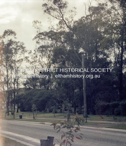
Photograph, Beard Street and Main Road Eltham, 20 Jan 1986, 20/01/1986
... Frame 01791-1 shows the auction sign for the land on the southeast corner of Main Road and Beard Street which was developed into a small group of shops eltham main road beard street eltham east service centre bp service station Kodak CL 200 5093 Roll of 35mm colour negative film, 4 strips Beard Street and Main Road Eltham, 20 Jan 1986 Photograph ...During the recent refurbishment of our Local History Centre we came across a roll of 35mm colour negatives which at some stage had been exposed to water or similar resulting in the individual strips sticking to each other and the old paper film processing envelope. The situation looked hopeless but one of our members had an idea on how to salvage them; after all, we had nothing to lose. In the end we were able to separate the film strips and remove most of the paper residue except some of the adhesive. The film was scanned and even though suffering from various light issues; fading, possible exposure problems and a yellow shadow cast by the adhesive residue, the detail and historical information they contain has been rescued. These images are all centred around the intersection of Beard Street and Main Road Eltham. The Sun headline is "Poison Dumped in Murray" which has been dated to 20 Jan 1986 1986 'Poison in Murray cuts town water', The Canberra Times (ACT : 1926 - 1995), 20 January, p. 1. , viewed 30 Aug 2017, http://nla.gov.au/nla.news-article122421767A favourite milk bar of the time for local youth as evidenced from comments on the ThrowbackThursday Facebook Page post. Frame 01791-1 shows the auction sign for the land on the southeast corner of Main Road and Beard Street which was developed into a small group of shopsRoll of 35mm colour negative film, 4 stripsKodak CL 200 5093eltham, main road, beard street, eltham east service centre, bp service station -
 Eltham District Historical Society Inc
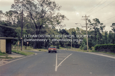
Photograph, Beard Street and Main Road Eltham, 20 Jan 1986, 20/01/1986
... Frame 01791-1 shows the auction sign for the land on the southeast corner of Main Road and Beard Street which was developed into a small group of shops eltham main road beard street eltham east service centre bp service station Kodak CL 200 5093 Roll of 35mm colour negative film, 4 strips Beard Street and Main Road Eltham, 20 Jan 1986 Photograph ...During the recent refurbishment of our Local History Centre we came across a roll of 35mm colour negatives which at some stage had been exposed to water or similar resulting in the individual strips sticking to each other and the old paper film processing envelope. The situation looked hopeless but one of our members had an idea on how to salvage them; after all, we had nothing to lose. In the end we were able to separate the film strips and remove most of the paper residue except some of the adhesive. The film was scanned and even though suffering from various light issues; fading, possible exposure problems and a yellow shadow cast by the adhesive residue, the detail and historical information they contain has been rescued. These images are all centred around the intersection of Beard Street and Main Road Eltham. The Sun headline is "Poison Dumped in Murray" which has been dated to 20 Jan 1986 1986 'Poison in Murray cuts town water', The Canberra Times (ACT : 1926 - 1995), 20 January, p. 1. , viewed 30 Aug 2017, http://nla.gov.au/nla.news-article122421767A favourite milk bar of the time for local youth as evidenced from comments on the ThrowbackThursday Facebook Page post. Frame 01791-1 shows the auction sign for the land on the southeast corner of Main Road and Beard Street which was developed into a small group of shopsRoll of 35mm colour negative film, 4 stripsKodak CL 200 5093eltham, main road, beard street, eltham east service centre, bp service station -
 Eltham District Historical Society Inc
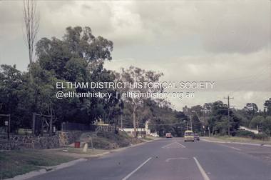
Photograph, Beard Street and Main Road Eltham, 20 Jan 1986, 20/01/1986
... Frame 01791-1 shows the auction sign for the land on the southeast corner of Main Road and Beard Street which was developed into a small group of shops eltham main road beard street eltham east service centre bp service station Kodak CL 200 5093 Roll of 35mm colour negative film, 4 strips Beard Street and Main Road Eltham, 20 Jan 1986 Photograph ...During the recent refurbishment of our Local History Centre we came across a roll of 35mm colour negatives which at some stage had been exposed to water or similar resulting in the individual strips sticking to each other and the old paper film processing envelope. The situation looked hopeless but one of our members had an idea on how to salvage them; after all, we had nothing to lose. In the end we were able to separate the film strips and remove most of the paper residue except some of the adhesive. The film was scanned and even though suffering from various light issues; fading, possible exposure problems and a yellow shadow cast by the adhesive residue, the detail and historical information they contain has been rescued. These images are all centred around the intersection of Beard Street and Main Road Eltham. The Sun headline is "Poison Dumped in Murray" which has been dated to 20 Jan 1986 1986 'Poison in Murray cuts town water', The Canberra Times (ACT : 1926 - 1995), 20 January, p. 1. , viewed 30 Aug 2017, http://nla.gov.au/nla.news-article122421767A favourite milk bar of the time for local youth as evidenced from comments on the ThrowbackThursday Facebook Page post. Frame 01791-1 shows the auction sign for the land on the southeast corner of Main Road and Beard Street which was developed into a small group of shopsRoll of 35mm colour negative film, 4 stripsKodak CL 200 5093eltham, main road, beard street, eltham east service centre, bp service station -
 Eltham District Historical Society Inc
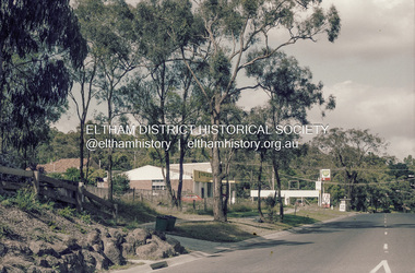
Photograph, Beard Street and Main Road Eltham, 20 Jan 1986, 20/01/1986
... Frame 01791-1 shows the auction sign for the land on the southeast corner of Main Road and Beard Street which was developed into a small group of shops eltham main road beard street eltham east service centre bp service station Kodak CL 200 5093 Roll of 35mm colour negative film, 4 strips Beard Street and Main Road Eltham, 20 Jan 1986 Photograph ...During the recent refurbishment of our Local History Centre we came across a roll of 35mm colour negatives which at some stage had been exposed to water or similar resulting in the individual strips sticking to each other and the old paper film processing envelope. The situation looked hopeless but one of our members had an idea on how to salvage them; after all, we had nothing to lose. In the end we were able to separate the film strips and remove most of the paper residue except some of the adhesive. The film was scanned and even though suffering from various light issues; fading, possible exposure problems and a yellow shadow cast by the adhesive residue, the detail and historical information they contain has been rescued. These images are all centred around the intersection of Beard Street and Main Road Eltham. The Sun headline is "Poison Dumped in Murray" which has been dated to 20 Jan 1986 1986 'Poison in Murray cuts town water', The Canberra Times (ACT : 1926 - 1995), 20 January, p. 1. , viewed 30 Aug 2017, http://nla.gov.au/nla.news-article122421767A favourite milk bar of the time for local youth as evidenced from comments on the ThrowbackThursday Facebook Page post. Frame 01791-1 shows the auction sign for the land on the southeast corner of Main Road and Beard Street which was developed into a small group of shopsRoll of 35mm colour negative film, 4 stripsKodak CL 200 5093eltham, main road, beard street, eltham east service centre, bp service station -
 Eltham District Historical Society Inc
Photograph, Beard Street and Main Road Eltham, 20 Jan 1986, 20/01/1986
... Frame 01791-1 shows the auction sign for the land on the southeast corner of Main Road and Beard Street which was developed into a small group of shops eltham main road beard street eltham east service centre bp service station Kodak CL 200 5093 Roll of 35mm colour negative film, 4 strips Beard Street and Main Road Eltham, 20 Jan 1986 Photograph ...During the recent refurbishment of our Local History Centre we came across a roll of 35mm colour negatives which at some stage had been exposed to water or similar resulting in the individual strips sticking to each other and the old paper film processing envelope. The situation looked hopeless but one of our members had an idea on how to salvage them; after all, we had nothing to lose. In the end we were able to separate the film strips and remove most of the paper residue except some of the adhesive. The film was scanned and even though suffering from various light issues; fading, possible exposure problems and a yellow shadow cast by the adhesive residue, the detail and historical information they contain has been rescued. These images are all centred around the intersection of Beard Street and Main Road Eltham. The Sun headline is "Poison Dumped in Murray" which has been dated to 20 Jan 1986 1986 'Poison in Murray cuts town water', The Canberra Times (ACT : 1926 - 1995), 20 January, p. 1. , viewed 30 Aug 2017, http://nla.gov.au/nla.news-article122421767A favourite milk bar of the time for local youth as evidenced from comments on the ThrowbackThursday Facebook Page post. Frame 01791-1 shows the auction sign for the land on the southeast corner of Main Road and Beard Street which was developed into a small group of shopsRoll of 35mm colour negative film, 4 stripsKodak CL 200 5093eltham, main road, beard street, eltham east service centre, bp service station
