Showing 97 items matching "spillway"
-
 Federation University Historical Collection
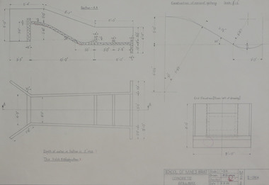
Student's Technical Drawing, Technical drawing - concrete spillway, 1962
... Technical drawing - concrete spillway....Pencil on paper student's technical drawing of concrete spillway...Barker Library (top floor) Mount Helen goldfields mining engineering technical drawing w. a. burrow School of Mining Ballarat Pencil on paper student's technical drawing of concrete spillway Technical drawing - concrete spillway. ...Pencil on paper student's technical drawing of concrete spillwaymining engineering, technical drawing, w. a. burrow, school of mining ballarat -
 Malmsbury Historical Society
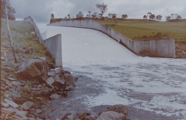
Photograph (Item), Western Spillway concrete Overflow, Malmsbury ca1990
... Western Spillway concrete Overflow, Malmsbury ca1990...Buildings - Concrete Spillway...Malmsbury Historical Society Malmsbury Mechanics Institute 71 Mollison Street Malmsbury daylesford-and-the-macedon-ranges Buildings - Concrete Spillway Western Spillway concrete Overflow, Malmsbury ca1990 Photograph Photograph ...Buildings - Concrete Spillway -
Malmsbury Historical Society
Photograph (Item), New Spillway After Removal Of Blue Stone, Malmsbury ca1990
... New Spillway After Removal Of Blue Stone, Malmsbury ca1990...Buildings - New Spillway At Res....Malmsbury Historical Society Malmsbury Mechanics Institute 71 Mollison Street Malmsbury daylesford-and-the-macedon-ranges Buildings - New Spillway At Res. New Spillway After Removal Of Blue Stone, Malmsbury ca1990 Photograph Photograph ...Buildings - New Spillway At Res. -
Stawell Historical Society Inc
Photograph, View to steps beside spillway Lake Lonsdale
... View to steps beside spillway Lake Lonsdale...View to steps beside spillway Lake Lonsdale...Stawell Historical Society Inc 46 Longfield St Stawell grampians View to steps beside spillway Lake Lonsdale Stawell View to steps beside spillway Lake Lonsdale Photograph ...View to steps beside spillway Lake Lonsdalestawell -
Stawell Historical Society Inc
Photograph, View across Lake Lonsdale Spillway Looking North
... View across Lake Lonsdale Spillway Looking North...View across Lake Lonsdale Spillway Looking North...Stawell Historical Society Inc 46 Longfield St Stawell grampians View across Lake Lonsdale Spillway Looking North Stawell View across Lake Lonsdale Spillway Looking North Photograph ...View across Lake Lonsdale Spillway Looking Northstawell -
Stawell Historical Society Inc
Photograph, View of spillway at Lake Lonsdale
... View of spillway at Lake Lonsdale...View of spillway Lake Lonsdale. House possibly Scoullar ...Stawell Historical Society Inc 46 Longfield St Stawell grampians View of spillway Lake Lonsdale. House possibly Scoullar Stawell View of spillway at Lake Lonsdale Photograph ...View of spillway Lake Lonsdale. House possibly Scoullar stawell -
 Wodonga & District Historical Society Inc
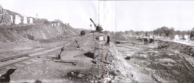
Album - Hume Reservoir Australia Album - Excavations for foundations of spillway, September 1921
... Hume Reservoir Australia Album - Excavations for foundations of spillway, September 1921....Excavation in progress for foundations of outlet and spillway sections of dam. September 1921....Excavation in progress for foundations of outlet and spillway sections of dam. September 1921. Hume Reservoir Australia Album - Excavations for foundations of spillway, September 1921. ...This set of photos is from a leather bound album bearing the inscription "HUME RESERVOIR AUSTRALIA" plus 'The Rt. Hon. L. C. M. S. Amery, P. C., M .P.' all inscribed in gold. It was presented to The Rt. Hon. L. C. M. S. Amery, P. C., M. P, Secretary of State for Dominion Affairs on the occasion of his visit to the Hume Reservoir on 2nd November 1927. This album is of local and national significance as it documents the planning and development of the Hume Reservoir up to 1927. It was the largest water reservoir in the British Empire. The album records the pioneering engineering work that went into its construction.DEPARTMENT OF PUBLIC WORKS, N.S.W. RIVER MURRAY WATERS SCHEME. HUME RESERVOIR. 6. Excavation in progress for foundations of outlet and spillway sections of dam. September 1921.hume reservoir australia, river murray waters scheme, hume weir diagrams, hume plan details -
 Lakes Entrance Historical Society
Photograph - Glenmaggie Weir Gippsland 1990
... also 2 other photos of the spillway 5220.1.and .2...Colour Photograph of spillway at Glenmaggie Weir Gipsland Victoria...also 2 other photos of the spillway 5220.1.and .2 Weirs Colour Photograph of spillway at Glenmaggie Weir Gipsland Victoria Photograph Glenmaggie Weir Gippsland 1990 ...also 2 other photos of the spillway 5220.1.and .2Colour Photograph of spillway at Glenmaggie Weir Gipsland Victoriaweirs -
 Buninyong & District Historical Society
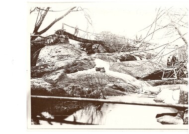
Photograph - Black and white photograph of Archibald Fisken on a bridge on Lal Lal Estate early 1900s, Archibald Fisken on "New Bridge" Lal Lal Estate early 1900s
... A black and white photograph showing a creek and Arthur Fisken standing on a wooden bridge to the rear over the spillway...Archibald Fisken on the New Bridge Early 1900s, an early bridge over the spillway Lal Lal Park...One of a series of photographs featuring the Fisken Family on the Lal Lal Estate The image shows a water system on an early Estate near Buninyong Fisken Family Lal Lal Estate Rural life Water ways Archibald Fisken on the New Bridge Early 1900s, an early bridge over the spillway Lal Lal Park A black and white photograph showing a creek and Arthur Fisken standing on a wooden bridge to the rear over the spillway Archibald Fisken on "New Bridge" Lal Lal Estate early 1900s Photograph Black and white photograph of Archibald Fisken on a bridge on Lal Lal Estate early 1900s ...One of a series of photographs featuring the Fisken Family on the Lal Lal EstateThe image shows a water system on an early Estate near BuninyongA black and white photograph showing a creek and Arthur Fisken standing on a wooden bridge to the rear over the spillwayArchibald Fisken on the New Bridge Early 1900s, an early bridge over the spillway Lal Lal Parkfisken family, lal lal estate, rural life, water ways -
 Ringwood and District Historical Society
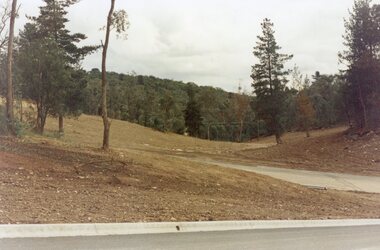
Photograph, Looking west across Werac and Kubis Drives, North Ringwood, in April 1978. Loughnan's Lake site. The retaining wall was where the truck tracks disappear over thhe ridge. The spillway was at that spot
... The retaining wall was where the truck tracks disappear over thhe ridge. The spillway was at that spot....The retaining wall was where the truck tracks disappear over thhe ridge. The spillway was at that spot. Photograph ...E548 N3 Part of a 51-photo record of the development of the "Kubis" Estate, Ringwood North, including road works to Debbie Place, Kubis Drive, Werac Drive, Manuelo Drive, Iluka Place and Glenvale Road. From the Jack Lundy Clarke collection. -
 Ringwood and District Historical Society
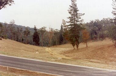
Photograph, Loughnan Lake site over Kubis Drive, North Ringwood, on 14 April 1978. The retaining wall was where the car tracks disappear over the ridge where the spillway was
... The retaining wall was where the car tracks disappear over the ridge where the spillway was....The retaining wall was where the car tracks disappear over the ridge where the spillway was. Photograph ...E548 N13 Part of a 51-photo record of the development of the "Kubis" Estate, Ringwood North, including road works to Debbie Place, Kubis Drive, Werac Drive, Manuelo Drive, Iluka Place and Glenvale Road. From the Jack Lundy Clarke collection. -
 Ringwood and District Historical Society
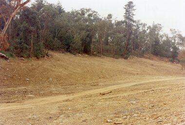
Photograph, "Kubis Estate", North Ringwood, in April 1978. Looking north-east over Loughnan's Lake greatest width. The rope tree was on the slope in the centre. The spillway was on the near left of the image
... The rope tree was on the slope in the centre. The spillway was on the near left of the image....The rope tree was on the slope in the centre. The spillway was on the near left of the image. Photograph ...E548 N17 Part of a 51-photo record of the development of the "Kubis" Estate, Ringwood North, including road works to Debbie Place, Kubis Drive, Werac Drive, Manuelo Drive, Iluka Place and Glenvale Road. From the Jack Lundy Clarke collection. -
Malmsbury Historical Society
Photograph (Item), Western Wall Of Spillway Landscape, Malmsbury ca1990
... Western Wall Of Spillway Landscape, Malmsbury ca1990...Western Wall Of Spillway Landscape, Malmsbury ca1990 Photograph Photograph ...Buildings - Malmsbury Res. -
 Yarrawonga and Mulwala Pioneer Museum
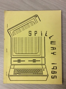
Magazine - School magazines, "Spillway" Yarrawonga High School, 1982 to 1989
... "Spillway" Yarrawonga High School...All Roneo printed. (2 x 1984) and (2 x 1985) "Spillway" Yarrawonga High School Magazine School magazines ...Contains references to students of the time, also form photos and sporting teams9 x black and white printed magazines approx. 30 pages stapled at spine. Includes black and white photos Plus Year 12 A4 size with plastic cover and plastic ring binding (1989). All Roneo printed. (2 x 1984) and (2 x 1985)see photos of front pagesyarrawonga high school -
 Yarrawonga and Mulwala Pioneer Museum
Magazine - School magazines, "Spillway", 1973 to 1976
... "Spillway"...Contain contributions from students and teachers "Spillway" Magazine School magazines ...Gives lists of students in their year groups, also teachers of the time. Headmaster Alph Smale 1973 to 1975 Headmistress Marjorie Mortimer 19764 Yarrawonga High School magazines 1973, 74,75,76. A4 size black and white printing and photos. Stapled at spines. Contain contributions from students and teachersSee photosyarrawonga high school, magazine -
 Ringwood and District Historical Society
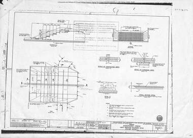
Plan, Metropolitan board of Works, North Ringwood retarding basin, energy dissipaters and spillway details, 31-May-79
... North Ringwood retarding basin, energy dissipaters and spillway details...Two A3 pages with drawings of Melbourne Metropolitan Board of Works of the North Ringwood retarding basin North Ringwood retarding basin, energy dissipaters and spillway details Plan Metropolitan board of Works ...Two A3 pages with drawings of Melbourne Metropolitan Board of Works of the North Ringwood retarding basin -
 Kiewa Valley Historical Society
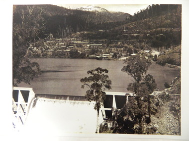
Photo - Early photo of Bogong Township x2
... This photo shows their homes and offices etc., Lake Guy and the spillway during construction days....Large photo of Mt Bogong Township with snow on the mountain in the background and the spillway over-flowing in the foreground. Some small trees amongst those burnt by the 1939 bushfire. (2 photos - one an enlarged copy)...This photo shows their homes and offices etc., Lake Guy and the spillway during construction days. Bogong village was built as part of the Kiewa Hydro Electric Scheme. ...Bogong Village was built for the workers of the State Elecricity Commission of Victoria who were employed to construct the Kiewa Hydro electric Scheme. This photo shows their homes and offices etc., Lake Guy and the spillway during construction days.Bogong village was built as part of the Kiewa Hydro Electric Scheme. This photo gives a view of the village when it was at its peak. Large photo of Mt Bogong Township with snow on the mountain in the background and the spillway over-flowing in the foreground. Some small trees amongst those burnt by the 1939 bushfire. (2 photos - one an enlarged copy)bogong village. kiewa hydro electric scheme. s.e.c.v.. lake guy. -
Tatura Irrigation & Wartime Camps Museum
Photograph, Eildon Reservoir - Goulburn River, 1918
... Eildon Reservoir on the Goulburn River / Overall picture of dam (Right of wall) filled with water and some leisure craft moored near shore and huts / Dam wall and spillway / tree covered hills beyond..."Eildon Reservoir - Goulburn River / Capacity - 306,000 acre feet / Rock filled dam with mass concrete spillway / Total length of dam - 3000 feet / Maximum depth of water - 123 feet - etc"...Eildon Reservoir on the Goulburn River / Overall picture of dam (Right of wall) filled with water and some leisure craft moored near shore and huts / Dam wall and spillway / tree covered hills beyond Eildon Reservoir - Goulburn River Photograph ...Taken by photographer for State Rivers and Water Supply Commission.Medium sized black and white photograph. Eildon Reservoir on the Goulburn River / Overall picture of dam (Right of wall) filled with water and some leisure craft moored near shore and huts / Dam wall and spillway / tree covered hills beyond"Eildon Reservoir - Goulburn River / Capacity - 306,000 acre feet / Rock filled dam with mass concrete spillway / Total length of dam - 3000 feet / Maximum depth of water - 123 feet - etc"victorian state rivers and supply commission, eildon dam -
 Bendigo Historical Society Inc.
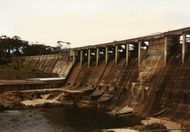
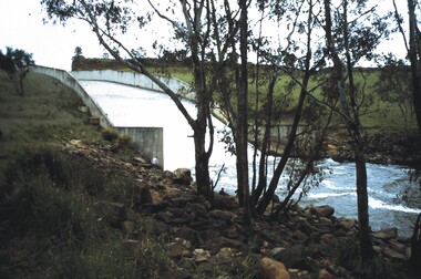
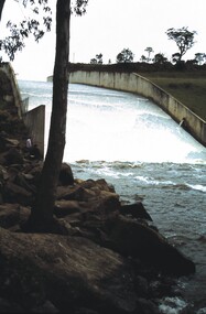
Slide - VAL DENSWORTH COLLECTION: EPPALOCK SPILLWAY, Oct 1988
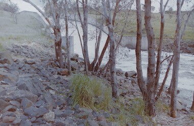
... Slide. Eppalock Spillway. Water cascading over the spillway....History House 11 Mackenzie Street Bendigo goldfields SLIDE Bendigo eppalock spillway. Eppalock Spillway. Slide. Eppalock Spillway. ...Slide. Eppalock Spillway. Water cascading over the spillway.slide, bendigo, eppalock spillway., eppalock spillway. -
 Bendigo Historical Society Inc.
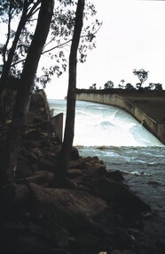
Slide - VAL DENSWORTH COLLECTION: EPPALOCK SPILLWAY, Oct 1988
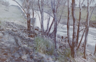
... Slide. Eppalock Spillway. Water flowing over the spillway....History House 11 Mackenzie Street Bendigo goldfields SLIDE Bendigo eppalock spillway. Eppalock Spillway. Slide. Eppalock Spillway. ...Slide. Eppalock Spillway. Water flowing over the spillway.slide, bendigo, eppalock spillway., eppalock spillway. -
 Bendigo Historical Society Inc.
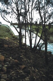
Slide - VAL DENSWORTH COLLECTION: EPPALOCK SPILLWAY, Oct 1988
... Slide. Eppalock Spillway. Water flowing over and down the spillway....History House 11 Mackenzie Street Bendigo goldfields SLIDE Bendigo eppalock spillway. Eppalock Spillway. Slide. Eppalock Spillway. ...Slide. Eppalock Spillway. Water flowing over and down the spillway.slide, bendigo, eppalock spillway., eppalock spillway. -
 Bendigo Historical Society Inc.
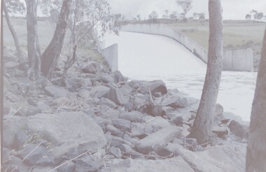
Slide - VAL DENSWORTH COLLECTION: EPPALOCK SPILLWAY, Oct 1988
... Slide. Eppalock Spillway. Water flowing over and down the spillway....History House 11 Mackenzie Street Bendigo goldfields SLIDE Bendigo eppalock spillway. Eppalock Spillway. Slide. Eppalock Spillway. ...Slide. Eppalock Spillway. Water flowing over and down the spillway.slide, bendigo, eppalock spillway., eppalock spillway. -
 Bendigo Historical Society Inc.
Slide - VAL DENSWORTH COLLECTION: LAKE EPPALOCK, 1986
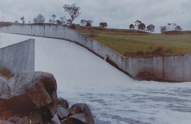
... Negative. Lake Eppalock spillway, water running over spillway. Dated November1986...History House 11 Mackenzie Street Bendigo goldfields SLIDE Bendigo Lake Eppalock spillway water running over spillway Negative. ...Negative. Lake Eppalock spillway, water running over spillway. Dated November1986slide, bendigo, lake eppalock spillway, water running over spillway -
 Bendigo Historical Society Inc.
Slide - VAL DENSWORTH COLLECTION: LAKE EPPALOCK, 1986
... Negative. Lake Eppalock spillway, water running over spillway. Dated November1986...History House 11 Mackenzie Street Bendigo goldfields SLIDE Bendigo lake eppalock Lake Eppalock water over spillway Negative. Lake Eppalock spillway, water running over spillway. ...Negative. Lake Eppalock spillway, water running over spillway. Dated November1986slide, bendigo, lake eppalock, lake eppalock water over spillway -
 Bendigo Historical Society Inc.
Slide - VAL DENSWORTH COLLECTION: LAKE EPPALOCK, 1986
... Negative. Lake Eppalock spillway, water running over spillway. Dated November1986...History House 11 Mackenzie Street Bendigo goldfields SLIDE Bendigo lake eppalock Lake Eppalock spillway near Bendigo Negative. Lake Eppalock spillway, water running over spillway. ...Negative. Lake Eppalock spillway, water running over spillway. Dated November1986slide, bendigo, lake eppalock, lake eppalock spillway near bendigo -
 Bendigo Historical Society Inc.
Slide - VAL DENSWORTH COLLECTION: LAKE EPPALOCK, 1986
... Negative. Lake Eppalock spillway, water running over spillway. Dated November 1986...History House 11 Mackenzie Street Bendigo goldfields SLIDE Bendigo lake eppalock Lake Eppalock spillway overflow Negative. Lake Eppalock spillway, water running over spillway. ...Negative. Lake Eppalock spillway, water running over spillway. Dated November 1986slide, bendigo, lake eppalock, lake eppalock spillway overflow -
 Bendigo Historical Society Inc.
Slide - VAL DENSWORTH COLLECTION: LAKE EPPALOCK, 1986
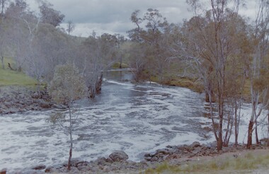
... Negative. Lake Eppalock spillway, Campaspe River at the base of the spillway. ...History House 11 Mackenzie Street Bendigo goldfields SLIDE Bendigo lake eppalock Lake Eppalock spillway Campaspe River Negative. Lake Eppalock spillway, Campaspe River at the base of the spillway. ...Negative. Lake Eppalock spillway, Campaspe River at the base of the spillway. Dated November 1986slide, bendigo, lake eppalock, lake eppalock spillway campaspe river -
 Bendigo Historical Society Inc.
Slide - VAL DENSWORTH COLLECTION: LAKE EPPALOCK, 1986
... Negative. Lake Eppalock spillway, water running over spillway. Dated November 1986...History House 11 Mackenzie Street Bendigo goldfields SLIDE Bendigo Lake Eppalock spillway water running over spillway Negative. ...Negative. Lake Eppalock spillway, water running over spillway. Dated November 1986slide, bendigo, lake eppalock spillway, water running over spillway -
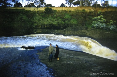 Melton City Libraries
Photograph, Melton Weir, 1961
... Family at the spillway in flood...Melton City Libraries 31 McKenzie Street Melton melbourne Misc. Family at the spillway in flood Melton Weir Photograph Barrie Collection ...Family at the spillway in floodmisc. -
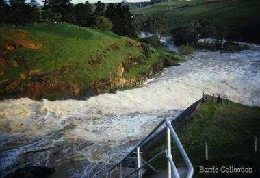 Melton City Libraries
Photograph, Melton Weir, 1961
... Family at the spillway in flood...Melton City Libraries 31 McKenzie Street Melton melbourne Misc. Family at the spillway in flood Melton Weir Photograph Barrie Collection ...Family at the spillway in floodmisc.