Showing 38 items matching "springvale road burwood"
-
 Whitehorse Historical Society Inc.
Photograph - Colour Photograph, Springvale Road East Burwood
... Springvale Road East Burwood...4 coloured photographs (a-d) taken at the intersection of Springvale Road & Burwood Hwy East Burwood. First stages of the Tally Ho Business Park in the background....Springvale Road East Burwood Photograph Colour Photograph ...The Tally Ho Business Park was built on vacant land previously owned by the Methodist Church. The land was sold cheaply to the Church by Abel Hoadley, and the Tally Ho Boys Home was erected there. A change in the care of the boys meant that the land became vacant for a considerable time before buildings appeared. The Country Fire Authority, Vic Roads and World Vision are also located there.4 coloured photographs (a-d) taken at the intersection of Springvale Road & Burwood Hwy East Burwood. First stages of the Tally Ho Business Park in the background.tally ho business park, businesses -
 Whitehorse Historical Society Inc.
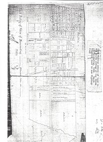
Document, Land Subdivision, cnr Springvale and Burwood Roads, n.d
... Burwood Road...Vermont South...Springvale...Springvale Road & Burwood Road, together with notes of various sales from 1857 to 1957....Hand drawn document of land subdivision, Springvale Road & Burwood Road, together with notes of various sales from 1857 to 1957....Whitehorse Historical Society Inc. 2-10 Deep Creek Road Mitcham melbourne Springvale Road & Burwood Road, together with notes of various sales from 1857 to 1957. ...Hand drawn document of land subdivision,Hand drawn document of land subdivision, Springvale Road & Burwood Road, together with notes of various sales from 1857 to 1957.Hand drawn document of land subdivision, burwood road, vermont south, springvale road, vermont south, stanley road, vermont south, vermont south, mayne, alexander, mayne, james alexander, craig, silas gordon, fankhauser, frederick william, fankhauser, mervyn william, burrell, charles, donaldson, john -
Whitehorse Historical Society Inc.
Map, Springvale Road, 1968
... Road...Burwood East...Burwood Highway...Burwood East...Springvale...Aerial photograph of cnr Springvale Road and Burwood Highway, south past Highbury Road....Whitehorse Historical Society Inc. 2-10 Deep Creek Road Mitcham melbourne Aerial photographs Highbury Road Burwood East Burwood Highway Burwood East Springvale Road Burwood East Aerial photograph of cnr Springvale Road and Burwood Highway, south past Highbury Road. ...Aerial photograph of cnr Springvale Road and Burwood Highway, south past Highbury Road.Aerial photograph of cnr Springvale Road and Burwood Highway, south past Highbury Road.Aerial photograph of cnr Springvale Road and Burwood Highway, south past Highbury Road.aerial photographs, highbury road, burwood east, burwood highway, burwood east, springvale road, burwood east -
 Whitehorse Historical Society Inc.
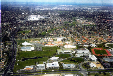
Photograph - Ariel Photograph, Tally Ho Office Park 1995, 1995
... ...springvale road burwood east...Aerial view of Tally Ho Office Park on corner of Springvale Road & Burwood Highway, East Burwood. Site partly developed. ...Whitehorse Historical Society Inc. 2-10 Deep Creek Road Mitcham melbourne lend lease development pty ltd tally ho office park springvale road burwood east burwood highway burwood east bill sewart athletic track Aerial view of Tally Ho Office Park on corner of Springvale Road & Burwood Highway, East Burwood. ...Aerial view of Tally Ho Office Park on corner of Springvale Road & Burwood Highway, East Burwood. Site partly developed. Shows East Burwood Reserve (part) and Bill Sewart Athletics Track. Photo taken facing Burwood Highway.lend lease development pty ltd, tally ho office park, springvale road burwood east, burwood highway burwood east, bill sewart athletic track -
Whitehorse Historical Society Inc.
Map, Springvale Road, 1987
... Road...Burwood East...Highbury Road...Burwood East...Burwood Highway...Burwood East...Springvale...Aerial photograph of cnr Springvale Road and Burwood Highway, south past Highbury Road and west past Blackburn Road....Whitehorse Historical Society Inc. 2-10 Deep Creek Road Mitcham melbourne Aerial photographs Blackburn Road Burwood East Highbury Road Burwood East Burwood Highway Burwood East Springvale Road Burwood East Burwood East Aerial photograph of cnr Springvale Road and Burwood Highway, south past Highbury Road and west past Blackburn Road. ...Aerial photograph of cnr Springvale Road and Burwood Highway, south past Highbury Road and west past Blackburn Road.Aerial photograph of cnr Springvale Road and Burwood Highway, south past Highbury Road and west past Blackburn Road.Aerial photograph of cnr Springvale Road and Burwood Highway, south past Highbury Road and west past Blackburn Road.aerial photographs, blackburn road, burwood east, highbury road, burwood east, burwood highway, burwood east, springvale road, burwood east, burwood east -
Whitehorse Historical Society Inc.
Map, Springvale Road, 1981
... ...Springvale Road...Burwood...Aerial photograph of area including cnr. Springvale Road and Burwood Highway, south past Highbury Road and west to Sevenoaks Road....Whitehorse Historical Society Inc. 2-10 Deep Creek Road Mitcham melbourne Aerial photographs Burwood East Springvale Road Burwood East Burwood Highway Burwood East Sevenoaks Road Burwood East Highbury Road Burwood East Aerial photograph of area including cnr. ...Aerial photograph of area including cnr. Springvale Road and Burwood Highway, south past Highbury Road and west to Sevenoaks Road.Aerial photograph of area including cnr. Springvale Road and Burwood Highway, south past Highbury Road and west to Sevenoaks Road.Aerial photograph of area including cnr. Springvale Road and Burwood Highway, south past Highbury Road and west to Sevenoaks Road.aerial photographs, burwood east, springvale road, burwood east, burwood highway, burwood east, sevenoaks road, burwood east, highbury road, burwood east -
Whitehorse Historical Society Inc.
Legal record - Land Title, Springvale Road, 1960
... ...Springvale Road...Burwood...Aerial photograph of cnr. Springvale Road and Burwood Highway, south past Highbury Road and east to Vermont South....Springvale Road and Burwood Highway, south past Highbury Road and east to Vermont South. ...Aerial photograph of cnr. Springvale Road and Burwood Highway, south past Highbury Road and east to Vermont South.Aerial photograph of cnr. Springvale Road and Burwood Highway, south past Highbury Road and east to Vermont South.Aerial photograph of cnr. Springvale Road and Burwood Highway, south past Highbury Road and east to Vermont South.aerial photographs, springvale road, burwood east, burwood highway, burwood east, highbury road, burwood east, vermont south -
Whitehorse Historical Society Inc.
Map, Springvale Road, 1990
... Road...Vermont South...Burwood Highway...Burwood East...Springvale...Aerial photograph of cnr Springvale Road and Burwood Highway, south past Highbury Road, west to Middleborough Road and east to Morack Road Vermont South....Whitehorse Historical Society Inc. 2-10 Deep Creek Road Mitcham melbourne Aerial photographs Morack Road Vermont South Burwood Highway Burwood East Springvale Road Burwood East Highbury Road Burwood East Burwood East Vermont South Aerial photograph of cnr Springvale Road and Burwood Highway, south past Highbury Road, west to Middleborough Road and east to Morack Road Vermont South. ...Aerial photograph of cnr Springvale Road and Burwood Highway, south past Highbury Road, west to Middleborough Road and east to Morack Road Vermont South.Aerial photograph of cnr Springvale Road and Burwood Highway, south past Highbury Road, west to Middleborough Road and east to Morack Road Vermont South.Aerial photograph of cnr Springvale Road and Burwood Highway, south past Highbury Road, west to Middleborough Road and east to Morack Road Vermont South.aerial photographs, morack road, vermont south, burwood highway, burwood east, springvale road, burwood east, highbury road, burwood east, burwood east, vermont south -
Whitehorse Historical Society Inc.
Document, Land sales, n.d
... springvale road...vermont south...burwood...Handwritten notes of land transactions 1855 - 1950, Crown Portion 109 bounded in part by Springvale and Burwood Roads....Whitehorse Historical Society Inc. 2-10 Deep Creek Road Mitcham melbourne land subdivision springvale road vermont south burwood highway stanley road mayne alexander james alexander craig mathew fergus silas gordon fankhauser frederick william clarence mervyn mcnees james de leece mackison ferguson samuel mcgarrel dennis campbell thomas burrell charles meyer jacob huebner otto mihan frederick donaldson john Handwritten notes of land transactions 1855 - 1950, Crown Portion 109 bounded in part by Springvale and Burwood Roads. ...Handwritten notes of land transactions 1855 - 1950, Crown Portion 109 bounded in part by Springvale and Burwood Roads.Handwritten notes of land transactions 1855 - 1950, Crown Portion 109 bounded in part by Springvale and Burwood Roads.Handwritten notes of land transactions 1855 - 1950, Crown Portion 109 bounded in part by Springvale and Burwood Roads.land subdivision, springvale road, vermont south, burwood highway, stanley road, mayne, alexander, james alexander, craig, mathew fergus, silas gordon, fankhauser, frederick william, clarence mervyn, mcnees, james, de leece, mackison, ferguson, samuel, mcgarrel, dennis, campbell, thomas, burrell, charles, meyer, jacob, huebner, otto, mihan, frederick, donaldson, john -
 Whitehorse Historical Society Inc.
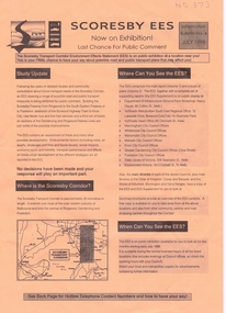
Pamphlet, Scoresby EES, 1/07/1998 12:00:00 AM
... ...springvale road burwood...Whitehorse Historical Society Inc. 2-10 Deep Creek Road Mitcham melbourne freeways scoresby transport corridor environment effects statement ringwood south eastern freeway frankston burwood highway dandenong victoria libraries transport land use springvale road burwood burwood tram services Information bulletin on the Scoresby Transport Corridor Information bulletin on the Scoresby Transport Corridor on exhibition for public comment. ...Information bulletin on the Scoresby Transport CorridorInformation bulletin on the Scoresby Transport Corridor on exhibition for public comment. It covers major possible transport projects in the area between Ringwood and Frankston including freeways, extensions to the Burwood tram line and the Glen Waverley Rail line.Information bulletin on the Scoresby Transport Corridorfreeways, scoresby transport corridor environment effects statement, ringwood, south eastern freeway, frankston, burwood highway, dandenong, victoria, libraries, transport, land use, springvale road burwood, burwood, tram services -
 Whitehorse Historical Society Inc.
Photograph, Subdivision of Area of Burwood, 1971
... road...burwood east...springvale...Black and white photo of Subdivision of Area of Burwood, Springvale and Highbury Roads....Whitehorse Historical Society Inc. 2-10 Deep Creek Road Mitcham melbourne highbury road burwood east springvale road burwood highway burwood east Subdivision Black and white photo of Subdivision of Area of Burwood, Springvale and Highbury Roads. ...Black and white photo of Subdivision of Area of Burwood, Springvale and Highbury Roads.highbury road, burwood east, springvale road, burwood highway burwood east, subdivision -
Whitehorse Historical Society Inc.
Article, School Kids Go 'Green', 22/09/1993 12:00:00 AM
... Final part of Melbourne Water's revegetation of 5 K section of Pipetrack between Springvale Road and Burwood Highway, involving Community Groups, incl. photo....Final part of Melbourne Water's revegetation of 5 K section of Pipetrack between Springvale Road and Burwood Highway, involving Community Groups, incl. photo....Whitehorse Historical Society Inc. 2-10 Deep Creek Road Mitcham melbourne Final part of Melbourne Water's revegetation of 5 K section of Pipetrack between Springvale Road and Burwood Highway, involving Community Groups, incl. photo. ...Primary School children plant trees along Melbourne Water Pipetrack in Forest Hills.Primary School children plant trees along Melbourne Water Pipetrack in Forest Hills. Final part of Melbourne Water's revegetation of 5 K section of Pipetrack between Springvale Road and Burwood Highway, involving Community Groups, incl. photo.Primary School children plant trees along Melbourne Water Pipetrack in Forest Hills. melbourne water, community groups, primary schools, bowden, cliff, torres, norman, jackson, katherine -
 Whitehorse Historical Society Inc.
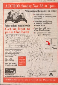
Newspaper - Article, Tally Ho Greens, 17/11/1993
... ...springvale road...burwood...Whitehorse Historical Society Inc. 2-10 Deep Creek Road Mitcham melbourne Bordered by Springvale Road and Highbury Road, 28-11-1993. auctions springvale road burwood east highbury road robinson drive hoadley crescent betts way trainor place sutton court cole close mcclelland way kennard place vision drive Advertisement in the Post for auction of 81 home sites on the Tally Ho Estate. ...Advertisement in the Post for auction of 81 home sites on the Tally Ho Estate.Advertisement in the Post for auction of 81 home sites on the Tally Ho Estate bordered by Springvale Road and Highbury Road, 28-11-1993.Advertisement in the Post for auction of 81 home sites on the Tally Ho Estate. auctions, springvale road, burwood east, highbury road, robinson drive, hoadley crescent, betts way, trainor place, sutton court, cole close, mcclelland way, kennard place, vision drive -
Whitehorse Historical Society Inc.
Document, History of Tally Ho Boys Home, 1972
... Road Burwood East...Highbury Road...Burwood East...Springvale... East Highbury Road Burwood East Springvale Road Burwood East Leach Nancy Hinneberg Ernest. ...Three papers on History of Boys Training Farm, Highbury Road, Tally Ho3 papers on History of Boys Training Farm, Highbury Road, Tally Ho, commenced in 1903 by Rev. and Mrs George Cole. The story covers the period from 1903-1930. The farm was built on land bought from Abel Hoadley for 1,000 Pounds near the corner of Springvale Road in Boundary Road (now Highbury Road). 2 letters (16/7/1972 & 28/5/1972) to Nancy Leach from E. Hinneberg, Assistant Superintendent, Tally Ho, about his association with Tally Ho.Three papers on History of Boys Training Farm, Highbury Road, Tally Hoyouth services, tally ho boys home, cole, george, rev., cole, mrs, hoadley, abel, boundary road burwood east, highbury road, burwood east, springvale road, burwood east, leach, nancy, hinneberg, ernest. -
Whitehorse Historical Society Inc.
Article, Tally Ho
... Road...Burwood East...Springvale...Whitehorse Historical Society Inc. 2-10 Deep Creek Road Mitcham melbourne Youth Services Tally Ho Boys Home Burwood East Highbury Road Burwood East Springvale Road Burwood East Burwood Road Burwood Tally Ho Youth Services Lingard Ian Three articles about the history and imminent move of Tally Ho Youth Centre. ...Three articles about the history and imminent move of Tally Ho Youth Centre.Three articles about the history and imminent move of Tally Ho Youth Centre.Three articles about the history and imminent move of Tally Ho Youth Centre.youth services, tally ho boys home, burwood east, highbury road, burwood east, springvale road burwood east, burwood road burwood, tally ho youth services, lingard, ian -
 Whitehorse Historical Society Inc.
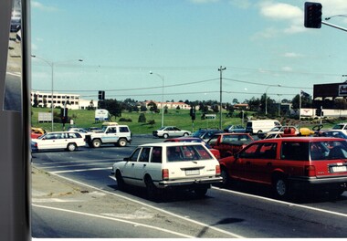
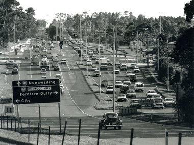
Photograph - B/W Photograph, Springvale Rd. and Burwood Highway intersection, 1999
... ...springvale road burwood east...Whitehorse Historical Society Inc. 2-10 Deep Creek Road Mitcham melbourne burwood highway burwood east springvale road burwood east Black and white photograph of the intersection of Burwood Highway and Springvale Rd. ...Black and white photograph of the intersection of Burwood Highway and Springvale Rd. East Burwood. Sign on left of photograph. Small black car in foreground.burwood highway burwood east, springvale road burwood east -
 Whitehorse Historical Society Inc.
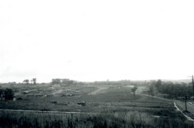
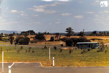
Photograph, Tally Ho Land
... Coloured photo of Tally Ho Land, Corner Springvale Road and Burwood Highway before development....Whitehorse Historical Society Inc. 2-10 Deep Creek Road Mitcham melbourne Tally Ho Coloured photo of Tally Ho Land, Corner Springvale Road and Burwood Highway before development. ...Coloured photo of Tally Ho Land, Corner Springvale Road and Burwood Highway before development.tally ho -
Whitehorse Historical Society Inc.
Map, Springvale Road, 1975
... Aerial photograph of area around cnr. of Springvale Road and Burwood Highway, south past Highbury Road and East in Vermont South....Aerial photograph of area around cnr. of Springvale Road and Burwood Highway, south past Highbury Road and East in Vermont South. ...Aerial photograph of area around cnr. of Springvale Road and Burwood Highway, south past Highbury Road and East in Vermont South.Aerial photograph of area around cnr. of Springvale Road and Burwood Highway, south past Highbury Road and East in Vermont South.Aerial photograph of area around cnr. of Springvale Road and Burwood Highway, south past Highbury Road and East in Vermont South.aerial photographs, vermont south, highbury road, burwood east, burwood highway, burwood east, burwood east -
 Whitehorse Historical Society Inc.
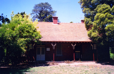
Photograph - Coloured photograph, Matheson's Home Forest Hill
... 8 coloured photographs (a-h) of the Matheson house and orchard on Springvale Road, East Burwood. House, shed, windmill, old orchard and pine and cyprus in the photographs....Springvale Road, as it was representative of one of the last working orchards in the Nunawading district. The property has now been vacant for many years (2011) and is secured with window bars and security services. Lately a large cyprus tree crashed onto the largest outbuilding and it was removed. matheson mary matheson orchard orchards Early Burwood Strathdon 8 coloured photographs (a-h) of the Matheson house and orchard on Springvale Road, East Burwood. ...The Nunawading orchard was purchased in 1920 by Mary Lilian Matheson from Florence Rebecca Course for a sum of 1050 Sterling Pound. In 1988 the Federal & State government allocated $125,000 to the Nunawading Council towards the purchase of the house, outbuildings and the orchard facing Springvale Road, as it was representative of one of the last working orchards in the Nunawading district. The property has now been vacant for many years (2011) and is secured with window bars and security services. Lately a large cyprus tree crashed onto the largest outbuilding and it was removed.8 coloured photographs (a-h) of the Matheson house and orchard on Springvale Road, East Burwood. House, shed, windmill, old orchard and pine and cyprus in the photographs.matheson, mary, matheson orchard, orchards, early burwood, strathdon -
 Whitehorse Historical Society Inc.
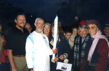
Photograph, Bob Gardiner and Olympic Flame, 1/09/2000 12:00:00 AM
... Coloured photo of Society members and ex Olympian, Bob Gardiner, carrying the Olympic Flame along Springvale Road between Burwood Highway and High Street Road.. ...Whitehorse Historical Society Inc. 2-10 Deep Creek Road Mitcham melbourne nunawading and district historical society gardiner bob olympic games arrowsmith valda warren frances kenny joy Coloured photo of Society members and ex Olympian, Bob Gardiner, carrying the Olympic Flame along Springvale Road between Burwood Highway and High Street Road.. ...Coloured photo of Society members and ex Olympian, Bob Gardiner, carrying the Olympic Flame along Springvale Road between Burwood Highway and High Street Road.. Other Society Members surround him.nunawading and district historical society, gardiner, bob, olympic games, arrowsmith, valda, warren, frances, kenny, joy -
Whitehorse Historical Society Inc.
Article, Council set to rezone land, 1992
... Council to rezone land Cnr Springvale and Burwood Roads to 'technology campus zone' so that Hewlett Packard can build its Australasian headquarters there....Whitehorse Historical Society Inc. 2-10 Deep Creek Road Mitcham melbourne Hewlett Packard Computer companies Cooper Les Council to rezone land Cnr Springvale and Burwood Roads to 'technology campus zone' so that Hewlett Packard can build its Australasian headquarters there. ...Council to rezone land Cnr Springvale and Burwood Roads to 'technology campus zone' so that Hewlett Packard can build its Australasian headquarters there.Council to rezone land Cnr Springvale and Burwood Roads to 'technology campus zone' so that Hewlett Packard can build its Australasian headquarters there.Council to rezone land Cnr Springvale and Burwood Roads to 'technology campus zone' so that Hewlett Packard can build its Australasian headquarters there.hewlett packard, computer companies, cooper, les -
Whitehorse Historical Society Inc.
Map, before 1890
... Early map showing location and areas of plots and their owners' names between Heatherdale Road in the east and Springvale Road in the west, Burwood Road to the south to north of Canterbury Road. ...Whitehorse Historical Society Inc. 2-10 Deep Creek Road Mitcham melbourne Mitcham Vermont Nunawading Early map showing location and areas of plots and their owners' names between Heatherdale Road in the east and Springvale Road in the west, Burwood Road to the south to north of Canterbury Road. ...Early map showing location and areas of plots and their owners' names between Heatherdale Road in the east and Springvale Road in the west, Burwood Road to the south to north of Canterbury Road. Later additions to 1969Early map showing location and areas of plots and their owners' names between Heatherdale Road in the east and Springvale Road in the west, Burwood Road to the south to north of Canterbury Road. Later additions to 1969Early map showing location and areas of plots and their owners' names between Heatherdale Road in the east and Springvale Road in the west, Burwood Road to the south to north of Canterbury Road. Later additions to 1969mitcham, vermont, nunawading -
Whitehorse Historical Society Inc.
Article, Burvale Hotel, 2015
... Burvale Hotel on the corner of Burwood Hwy and Springvale Road, Vermont South will be considered for heritage listing....Whitehorse Historical Society Inc. 2-10 Deep Creek Road Mitcham melbourne Will be considered for heritage listing. Burvale Hotel heritage Burvale Hotel on the corner of Burwood Hwy and Springvale Road, Vermont South. ...Burvale Hotel on the corner of Burwood Hwy and Springvale Road, Vermont South.Burvale Hotel on the corner of Burwood Hwy and Springvale Road, Vermont South will be considered for heritage listing.Burvale Hotel on the corner of Burwood Hwy and Springvale Road, Vermont South. burvale hotel, heritage -
Whitehorse Historical Society Inc.
Document, Horticultural Heritage Advice, 1/11/2002 12:00:00 AM
... Springvale Road...Forest Hill No. 449...Mount Pleasant Road...Forest Hill No. 129...Blackburn Road...Burwood...At 5 Longland Rd, Heatherdale, 449 Springvale Road, Forest Hill, 129 Mount Pleasant Road, Forest Hill and 347 Blackburn Road, Burwood East including aerial photographs by Francine Gilfedder & Associates....A list of significant trees at 5 Longland Rd, Heatherdale, 449 Springvale Road, Forest Hill, 129 Mount Pleasant Road, Forest Hill and 347 Blackburn Road, Burwood East including aerial photographs by Francine Gilfedder & Associates....Heritage Studies Horticulture Longland Road Heatherdale No. 5 Springvale Road Forest Hill No. 449 Mount Pleasant Road Forest Hill No. 129 Blackburn Road Burwood East No 347 Gilfedder Francine A list of significant trees. ...A list of significant trees.A list of significant trees at 5 Longland Rd, Heatherdale, 449 Springvale Road, Forest Hill, 129 Mount Pleasant Road, Forest Hill and 347 Blackburn Road, Burwood East including aerial photographs by Francine Gilfedder & Associates.A list of significant trees. heritage studies, horticulture, longland road, heatherdale no. 5, springvale road, forest hill no. 449, mount pleasant road, forest hill no. 129, blackburn road, burwood east no 347, gilfedder francine -
 Whitehorse Historical Society Inc.
Map, Shire of Nunawading 1888
... road...burwood east...highbury road...springvale...Whitehorse Historical Society Inc. 2-10 Deep Creek Road Mitcham melbourne shire of nunawading. south riding south boundary road burwood east highbury road springvale road mahoneys road forest hill holland road blackburn south burwood highway Plan showing owners of land in the South Riding of the Shire of Nunawading, 1888. ...Plan showing owners of land in the South Riding of the Shire of Nunawading, 1888. South Boundary Road is now Highbury Road.shire of nunawading. south riding, south boundary road, burwood east, highbury road, springvale road, mahoneys road, forest hill, holland road, blackburn south, burwood highway -
Whitehorse Historical Society Inc.
Map, City of Nunawading, 1980?
... Map of the City of Nunawading showing streets to south of Burwood Highway and east of Springvale Road....Whitehorse Historical Society Inc. 2-10 Deep Creek Road Mitcham melbourne City of Nunawading historical Map of the City of Nunawading showing streets to south of Burwood Highway and east of Springvale Road. ...Map of the City of Nunawading showing streets to south of Burwood Highway and east of Springvale Road.Map of the City of Nunawading showing streets to south of Burwood Highway and east of Springvale Road.Map of the City of Nunawading showing streets to south of Burwood Highway and east of Springvale Road.city of nunawading, historical -
Whitehorse Historical Society Inc.
Article, New tram link proves popular, 1979
... Photocopy of article quoting Keith McCance, state member for Bennetswood commenting on the increase in patronage of the Burwood Road tram extension from Warrigal Road to Middleborough Road. Pressure is being applied to extend to Springvale Road....Whitehorse Historical Society Inc. 2-10 Deep Creek Road Mitcham melbourne Pressure is being applied to extend to Springvale Road. Tram services Burwood Road Burwood McCance Keith Photocopy of article quoting Keith McCance, state member for Bennetswood commenting on the increase in patronage of the Burwood Road tram extension from Warrigal Road to Middleborough Road. ...Photocopy of article quoting Keith McCance, state member for Bennetswood commenting on the increase in patronage of the Burwood Road tram extension from Warrigal Road to Middleborough Road.Photocopy of article quoting Keith McCance, state member for Bennetswood commenting on the increase in patronage of the Burwood Road tram extension from Warrigal Road to Middleborough Road. Pressure is being applied to extend to Springvale Road.Photocopy of article quoting Keith McCance, state member for Bennetswood commenting on the increase in patronage of the Burwood Road tram extension from Warrigal Road to Middleborough Road. tram services, burwood road, burwood, mccance, keith -
Whitehorse Historical Society Inc.
Map, Aerial maps, 2/04/1966 12:00:00 AM
... Roads; E. Dubon Rd; N Oban Rd; S Reilly St. Map No 107. W. Indra Rd and Pakenham St; E. Rooks Rd & McLares Rd; N. Maroondah Hwy; S. Hawthorn Rd & Eley Rd. Map No 109 W. Elgar Rd. E. Blackburn Rd & McKean St; S. Eley Rd & Burwood Hwy. Map No 161. W. Elgar Rd & Huntingdale Rd; E. Blackburn Rd; N. Burwood Hwy; S. Waverley Rd. Map No 163. W. Blackburn Rd; S. Springvale...Roads; E. Dubon Rd; N Oban Rd; S Reilly St. Map No 107. W. Indra Rd and Pakenham St; E. Rooks Rd & McLares Rd; N. Maroondah Hwy; S. Hawthorn Rd & Eley Rd. Map No 109 W. Elgar Rd. E. Blackburn Rd & McKean St; S. Eley Rd & Burwood Hwy. Map No 161. W. Elgar Rd & Huntingdale Rd; E. Blackburn Rd; N. Burwood Hwy; S. Waverley Rd. Map No 163. W. Blackburn Rd; S. Springvale ...Melbourne 1966 project, runs 10A and 11A, lens 122 151.75 mm 9,800. Photo nos 77, 107, 109, 161, 163, 165.Melbourne 1966 project, runs 10A,11A and 12A, lens 122 151.75 mm 9,800. Photo nos 77, 107, 109, 161, 163, 165. Areas and boundaries: Map no 77 W. Park and Cook Roads; E. Dubon Rd; N Oban Rd; S Reilly St. Map No 107. W. Indra Rd and Pakenham St; E. Rooks Rd & McLares Rd; N. Maroondah Hwy; S. Hawthorn Rd & Eley Rd. Map No 109 W. Elgar Rd. E. Blackburn Rd & McKean St; S. Eley Rd & Burwood Hwy. Map No 161. W. Elgar Rd & Huntingdale Rd; E. Blackburn Rd; N. Burwood Hwy; S. Waverley Rd. Map No 163. W. Blackburn Rd; S. Springvale Rd; N. Eley Rd & Hawthorn Rd; S. Glen Waverley Railway Line. Map No 165. W. Stanley Rd, Vermont South; E. Cathies Lane, Wantirna South; N. North of Burwood Hwy; S. High Street. Melbourne 1966 project, runs 10A and 11A, lens 122 151.75 mm 9,800. Photo nos 77, 107, 109, 161, 163, 165. aerial photographs, blackburn, blackburn south, forest hill, nunawading, box hill, burwood, burwood east, donvale, mount waverley, glen waverley, wantirna, vermont south, mitcham, ringwood north, ringwood -
Whitehorse Historical Society Inc.
Article, New park takes shape, 1986
... Article about the development of Tally Ho Technology Park on corner of Burwood Highway and Springvale Road....Whitehorse Historical Society Inc. 2-10 Deep Creek Road Mitcham melbourne tally ho industrial park Development Article about the development of Tally Ho Technology Park on corner of Burwood Highway and Springvale Road. ...Article about the development of Tally Ho Technology Park on corner of Burwood Highway and Springvale Road.Article about the development of Tally Ho Technology Park on corner of Burwood Highway and Springvale Road.Article about the development of Tally Ho Technology Park on corner of Burwood Highway and Springvale Road.tally ho industrial park, development -
Whitehorse Historical Society Inc.
Map, Aerial photograph, c1950
... Aerial photo of Vermont South and Burwood East, Middleborough Road, Burwood Highway, Springvale Road, Highbury Road and environs....Whitehorse Historical Society Inc. 2-10 Deep Creek Road Mitcham melbourne vermont south burwood east aerial photographs Arial photo of Vermont South and Burwood East, Middleborough Road, Burwood Highway, Springvale Road, Highbury Road and environs. ...Arial photo of Vermont South and Burwood East, Middleborough Road, Burwood Highway, Springvale Road, Highbury Road and environs.Aerial photo of Vermont South and Burwood East, Middleborough Road, Burwood Highway, Springvale Road, Highbury Road and environs.Arial photo of Vermont South and Burwood East, Middleborough Road, Burwood Highway, Springvale Road, Highbury Road and environs.vermont south, burwood east, aerial photographs