Showing 12 items matching "squatting runs"
-
 Marysville & District Historical Society
Document (item) - Research document, Gerald W. Noble, EARLY SQUATTING RUNS IN REGION, Original book published in 1969
... EARLY SQUATTING RUNS IN REGION......squatting runs...Noble, that outlines the history of the various squatting runs in the regions surrounding Marysville. ...Noble, that outlines the history of the various squatting runs in the regions surrounding Marysville. ...Noble, that outlines the history of the various squatting runs in the regions surrounding Marysville. ...A copy of pages from "The Red Gate, A History of Alexandra, by Gerald W. Noble, that outlines the history of the various squatting runs in the regions surrounding Marysville. The original book was published in 1969.A copy of pages from "The Red Gate, A History of Alexandra, by Gerald W. Noble, that outlines the history of the various squatting runs in the regions surrounding Marysville. The original book was published in 1969.marysville, victoria, australia, squatting runs, thornton station, torbreck station, dry creek, mount pleasant, mount pleasant 'a', mount pleasant 'b', acheron station, taggerty station, granton station, wanregarwan station, wanregnan station, riversdale no 2 station, niagaroon station, niagaroon, riversdale no 1 station, mohican station, jones station, charon station, research document, , the red gate, history of alexandra, gerald w. noble, sutledge station, styx station -
 Kiewa Valley Historical Society
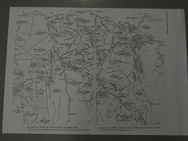
Maps - Squatting Runs of the Murray District 1848 x2, July 26,1848
... Maps - Squatting Runs of the Murray District 1848 x2 ...Squatting Runs; Kiewa Valley; Port Phillip District;...2 copies - 1 laminated & 1 paper of the map of "Squatting Runs of the Murray District 1848." The area is recorded (eg. ...Scale is 8 miles to the inch. Maps - Squatting Runs of the Murray District 1848 x2 ...The Port Phillip Gazette was the second newspaper published in Melbourne, in the then Port Phillip district, now Victoria. In 1948 it was published bi-weekly.The map shows the original names of squatters along the Kiewa River. The names of the district are mostly current today although some are spelt differently.2 copies - 1 laminated & 1 paper of the map of "Squatting Runs of the Murray District 1848." The area is recorded (eg. Tawanga, Dederang, Gundowring, Kergunia, Merrimarenbung all along the Kiewa River) under which the names of the squatter is recorded, the number of acres and the licence number. Scale is 8 miles to the inch.squatting runs; kiewa valley; port phillip district; -
 Kiewa Valley Historical Society
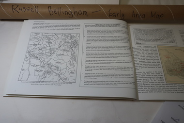
Map - Early Area Map in 1848 with Squatters Page 6 of "A Farming Journey", Early 1848 Area Map from A Farming Journey Page 6
... Squatting Runs map 1848...Roll of hand drawn map depicting 'Squatting Runs of the Murray District 1848 in Victoria. ...Squatting Runs map 1848 Dederang Tawanga Gundowring Kergunyah Roll of hand drawn map depicting 'Squatting Runs of the Murray District 1848 in Victoria. ...This map shows the following: The name as spelt in 1848; the licence number as found in Port Phillip Gazette for July 26, 1848; name of licensee; estimated area in acres. The scale is 8 miles to the inch.A map showing the squatting runs in 1848 including the names of the squatters , the licenxe numberand the area in acres. Roll of hand drawn map depicting 'Squatting Runs of the Murray District 1848 in Victoria. Created by squatting runs map 1848, dederang, tawanga, gundowring, kergunyah -
 Narre Warren and District Family History Group
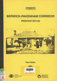
Book, Paul Hicks, Berwick-Pakenham Corridor: Historical Survey, 1991
... ...Westernport Squatting Runs...Narre Warren and District Family History Group 110 High Street Berwick melbourne County of Mornington Early Houses of Berwick Westernport Squatting Runs Shows early Geological maps of Berwick area, Squatting runs, Aboriginal tribal boundaries, early house, townships and early landmarks Berwick-Pakenham Corridor: Historical Survey Book Paul Hicks ...Shows early Geological maps of Berwick area, Squatting runs, Aboriginal tribal boundaries, early house, townships and early landmarksnon-fictionShows early Geological maps of Berwick area, Squatting runs, Aboriginal tribal boundaries, early house, townships and early landmarkscounty of mornington, early houses of berwick, westernport squatting runs -
 Federation University Historical Collection
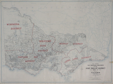
Plan, Map Showing the Pastoral Holdings of the Port Phillip District 1835-1851 Now Victoria, 1932, 1932
... Another name for Pastoral Holdings is squatting runs. Information on Alfred Stephen Kenyon of the Historical Society of Victoria can be found at http://adb.anu.edu.au/biography/kenyon-alfred-stephen-6936/text12035 ...Barker Library (top floor) Mount Helen goldfields Another name for Pastoral Holdings is squatting runs. Information on Alfred Stephen Kenyon of the Historical Society of Victoria can be found at http://adb.anu.edu.au/biography/kenyon-alfred-stephen-6936/text12035 pastoral holdings squatters squatting victoria land crown lands a.s. kenyon alfred stephen kenyon Map of Victoria showing the boundaries of the Port Phillip District (Victoria) pastoral boundaries. ...Another name for Pastoral Holdings is squatting runs. Information on Alfred Stephen Kenyon of the Historical Society of Victoria can be found at http://adb.anu.edu.au/biography/kenyon-alfred-stephen-6936/text12035 Map of Victoria showing the boundaries of the Port Phillip District (Victoria) pastoral boundaries. pastoral holdings, squatters, squatting, victoria, land, crown lands, a.s. kenyon, alfred stephen kenyon -
 Stawell Historical Society Inc
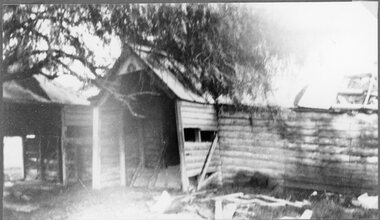
Photograph, "Ashen" Homestead Remnants in Murtoa after a Storm c1920’s
... Dugald McPherson's Ashen's Homestead (Remnants) c1920’s Ashen's south of Murtoa was one of the area's original squatting runs. This photo taken in the 1920's shows the homestead after a violent storm had been through the area. ...Stawell Historical Society Inc 46 Longfield St Stawell grampians Dugald McPherson's Ashen's Homestead (Remnants) c1920’s Ashen's south of Murtoa was one of the area's original squatting runs. This photo taken in the 1920's shows the homestead after a violent storm had been through the area. ...Dugald McPherson's Ashen's Homestead (Remnants) c1920’s Ashen's south of Murtoa was one of the area's original squatting runs. This photo taken in the 1920's shows the homestead after a violent storm had been through the area. In 1853, the country around Ashen's was covered by timber, she-oaks, bull-oaks, light gum and box thickets of ti-tree and clumps of pine and wattles. The vegetation was so thick outside the horse paddock it was difficult to move in any direction. It was said McPherson and two others fought over the land.Back entrance to Ashen's Station.stawell -
Tatura Irrigation & Wartime Camps Museum
Book, Edward M. Curr. The Tide of History
... Map of the runs of the late E. M. Curr, St. Helliers. Recollections of squatting in Victoria. ...Tatura Irrigation & Wartime Camps Museum 49 Hogan Street Tatura the-murray Map of the runs of the late E. M. Curr, St. Helliers. Recollections of squatting in Victoria. ...Map of the runs of the late E. M. Curr, St. Helliers. Recollections of squatting in Victoria. Map of Angerang Territory.Front cover profile in red of E. M. Curr. Cover images. Signed by Samuel Furphy, authoredward m curr, st helliers, angerang territory -
 Wodonga & District Historical Society Inc
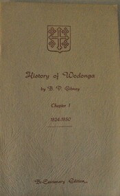
Booklet - History of Wodonga : Chapter 1 1824 - 1850, B. P. Gibney, Exploration and Settlement, 1970
... It focuses on exploration and settlement from the arrival of Hume and Hovell in 1824 and outlines the different families who took up squatting runs in the district. At bottom of cover: Bi-Centenary Edition A small buff coloured booklet of 16 pages. ...This booklet is an imprint of written by Bernie Gibney on behalf of the Wodonga Branch of the North Eastern Historical Society to commemorate the Cook Bicentenary. It tells the story of the early years of European settlement of the Wodonga area. It focuses on exploration and settlement from the arrival of Hume and Hovell in 1824 and outlines the different families who took up squatting runs in the district.A small buff coloured booklet of 16 pages. The text is printed in red print and bears the coat of arms of the Australian branch of the Huon and De Kerilleau family.non-fictionThis booklet is an imprint of written by Bernie Gibney on behalf of the Wodonga Branch of the North Eastern Historical Society to commemorate the Cook Bicentenary. It tells the story of the early years of European settlement of the Wodonga area. It focuses on exploration and settlement from the arrival of Hume and Hovell in 1824 and outlines the different families who took up squatting runs in the district.wodonga history, early settlement wodonga, huon family, de kerilleau -
 Flagstaff Hill Maritime Museum and Village
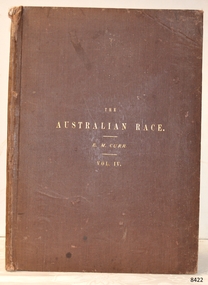
Book - Ethnographic survey, Edward Micklethwaite Curr, The Australian Race Vol 4, 1886-1887
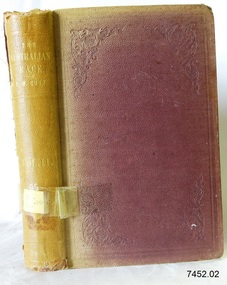
... He is best known for the subject work “The Australian Race” and for writing about early squatting life in Victoria and Aboriginal languages and customs. Curr was educated in England, then managed sheep runs in Victoria for his father before later holding senior colonial stock inspection roles, including Chief Inspector of Sheep and later Chief Inspector of Stock in Victoria. ...He is best known for the subject work “The Australian Race” and for writing about early squatting life in Victoria and Aboriginal languages and customs. Curr was educated in England, then managed sheep runs in Victoria for his father before later holding senior colonial stock inspection roles, including Chief Inspector of Sheep and later Chief Inspector of Stock in Victoria. ...The Australian Race Vol. 4 by Edward M. Curr is the highly illustrated fourth part of Curr’s four volume ethnographic survey of Aboriginal Australia. It consolidates his findings on origins, languages, customs, and distributions, and its atlas volume furnishes a large comparative language map and ethnographic plates. The four volume set are a broad survey of Aboriginal peoples’ origins, languages, social customs, and movements across the Australian continent. The fourth volume functions as an atlas and language compendium, pairing textual material with a folio atlas of comparative vocabularies and a large map that traces routes and distributions. This volume also documents specific rites and regional practices, as part of his broader attempt to synthesize ethnographic and linguistic data across Australia. The work is considered a foundational reference work although in today's modern world is is regarded as dated and eurocentric set of volumes as a reference in Australian Indigenous studies and anthropology.Hard cover book, The Australian Race Vol 4. Author: Edward Micklethwaite Curr Publisher: John Ferres, Government Printer Melbourne Aus. Date: 1886-1887 Light brown cloth hardcover and spine and blue edging to hard covers lettering in blue . The spine has a label with an inscription. Further Information: Map in pocket at the back of volnon-fictionThe Australian Race Vol. 4 by Edward M. Curr is the highly illustrated fourth part of Curr’s four volume ethnographic survey of Aboriginal Australia. It consolidates his findings on origins, languages, customs, and distributions, and its atlas volume furnishes a large comparative language map and ethnographic plates. The four volume set are a broad survey of Aboriginal peoples’ origins, languages, social customs, and movements across the Australian continent. The fourth volume functions as an atlas and language compendium, pairing textual material with a folio atlas of comparative vocabularies and a large map that traces routes and distributions. This volume also documents specific rites and regional practices, as part of his broader attempt to synthesize ethnographic and linguistic data across Australia. The work is considered a foundational reference work although in today's modern world is is regarded as dated and eurocentric set of volumes as a reference in Australian Indigenous studies and anthropology.flagstaff hil, warrnambool, flagstaff hill maritime museum, maritime museum, shipwreck coast, flagstaff hill maritime village, great ocean road, book, pattison collection, warrnambool library, warrnambool mechanics’ institute, ralph eric pattison, corangamite regional library service, warrnambool city librarian, mechanics’ institute library, victorian library board, warrnambool books and records, warrnambool children’s library, the australian race vol 4, aboriginal studies, languages, native langauge -
 Flagstaff Hill Maritime Museum and Village
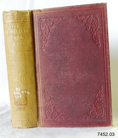
Book - Ethnographic survey, Edward Micklethwaite Curr, The Australian Race Vol 3, 1886-1887
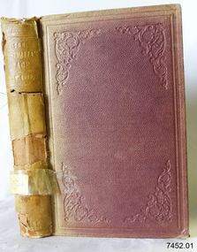
... He is best known for the subject work “The Australian Race” and for writing about early squatting life in Victoria and Aboriginal languages and customs. Curr was educated in England, then managed sheep runs in Victoria for his father before later holding senior colonial stock inspection roles, including Chief Inspector of Sheep and later Chief Inspector of Stock in Victoria. ...He is best known for the subject work “The Australian Race” and for writing about early squatting life in Victoria and Aboriginal languages and customs. Curr was educated in England, then managed sheep runs in Victoria for his father before later holding senior colonial stock inspection roles, including Chief Inspector of Sheep and later Chief Inspector of Stock in Victoria. ...The Australian Race Vol. 3 by Edward M. Curr is the third part of Curr’s four volume ethnographic survey of Aboriginal Australia. Volume three moves further into Aboriginal customs their social practices, and regional accounts gathered from settlers, missionaries, and other correspondents of the time. The four volume set is a broad survey of Aboriginal peoples’ origins, languages, social customs, and movements across the Australian continent. Volume one is chiefly a comparative on various vocabularies and linguistic materials, with early observations used to identify and compare Aboriginal language groups. This volume continuing in documenting specific rites and regional practices, as part of his broader attempt to synthesize ethnographic and linguistic data across Australia. The work is considered a foundational reference work although in today's modern world is is regarded as dated and eurocentric set of volumes as a reference in Australian Indigenous studies and anthropology.Hard cover book, The Australian Race Vol 3. Author: Edward Micklethwaite Curr Publisher: John Ferres, Government Printer Melbourne Aus. Date: 1886-1887 Light brown cloth hardcover and spine and blue edging to hard covers lettering in blue . The spine has a label with an inscription.non-fictionThe Australian Race Vol. 3 by Edward M. Curr is the third part of Curr’s four volume ethnographic survey of Aboriginal Australia. Volume three moves further into Aboriginal customs their social practices, and regional accounts gathered from settlers, missionaries, and other correspondents of the time. The four volume set is a broad survey of Aboriginal peoples’ origins, languages, social customs, and movements across the Australian continent. Volume one is chiefly a comparative on various vocabularies and linguistic materials, with early observations used to identify and compare Aboriginal language groups. This volume continuing in documenting specific rites and regional practices, as part of his broader attempt to synthesize ethnographic and linguistic data across Australia. The work is considered a foundational reference work although in today's modern world is is regarded as dated and eurocentric set of volumes as a reference in Australian Indigenous studies and anthropology.flagstaff hil, warrnambool, flagstaff hill maritime museum, maritime museum, shipwreck coast, flagstaff hill maritime village, great ocean road, book, pattison collection, warrnambool library, warrnambool mechanics’ institute, ralph eric pattison, corangamite regional library service, warrnambool city librarian, mechanics’ institute library, victorian library board, warrnambool books and records, warrnambool children’s library, the australian race vol 4, aboriginal studies, languages, native langauge -
 Flagstaff Hill Maritime Museum and Village
Book - Ethnographic survey, Edward Micklethwaite Curr, The Australian Race Vol 2, 1886-1887
... He is best known for the subject work “The Australian Race” and for writing about early squatting life in Victoria and Aboriginal languages and customs. Curr was educated in England, then managed sheep runs in Victoria for his father before later holding senior colonial stock inspection roles, including Chief Inspector of Sheep and later Chief Inspector of Stock in Victoria. ...He is best known for the subject work “The Australian Race” and for writing about early squatting life in Victoria and Aboriginal languages and customs. Curr was educated in England, then managed sheep runs in Victoria for his father before later holding senior colonial stock inspection roles, including Chief Inspector of Sheep and later Chief Inspector of Stock in Victoria. ...The Australian Race Vol. 2 by Edward M. Curr is the second part of Curr’s four volume ethnographic survey of Aboriginal Australia. Volume two continues the language and vocabulary work from volume one, and goes on in expanding the comparative material available across more regions and groups of Aboriginal tribes or mobs. The four volume set is a broad survey of Aboriginal peoples’ origins, languages, social customs, and movements across the Australian continent. Volume one is chiefly a comparative on various vocabularies and linguistic materials, with early observations used to identify and compare Aboriginal language groups. This volume also documents specific rites and regional practices, as part of his broader attempt to synthesize ethnographic and linguistic data across Australia. The work is considered a foundational reference work although in today's modern world is is regarded as dated and eurocentric set of volumes as a reference in Australian Indigenous studies and anthropology.Hard cover book, The Australian Race Vol 2. Author: Edward Micklethwaite Curr Publisher: John Ferres, Government Printer Melbourne Aus. Date: 1886-1887 Light brown cloth hardcover and spine and blue edging to hard covers lettering in blue . The spine has a label with an inscription.non-fictionThe Australian Race Vol. 2 by Edward M. Curr is the second part of Curr’s four volume ethnographic survey of Aboriginal Australia. Volume two continues the language and vocabulary work from volume one, and goes on in expanding the comparative material available across more regions and groups of Aboriginal tribes or mobs. The four volume set is a broad survey of Aboriginal peoples’ origins, languages, social customs, and movements across the Australian continent. Volume one is chiefly a comparative on various vocabularies and linguistic materials, with early observations used to identify and compare Aboriginal language groups. This volume also documents specific rites and regional practices, as part of his broader attempt to synthesize ethnographic and linguistic data across Australia. The work is considered a foundational reference work although in today's modern world is is regarded as dated and eurocentric set of volumes as a reference in Australian Indigenous studies and anthropology.flagstaff hil, warrnambool, flagstaff hill maritime museum, maritime museum, shipwreck coast, flagstaff hill maritime village, great ocean road, book, pattison collection, warrnambool library, warrnambool mechanics’ institute, ralph eric pattison, corangamite regional library service, warrnambool city librarian, mechanics’ institute library, victorian library board, warrnambool books and records, warrnambool children’s library, the australian race vol 4, aboriginal studies, languages, native langauge -
 Flagstaff Hill Maritime Museum and Village
Book - Ethnographic survey, Edward Micklethwaite Curr, The Australian Race Vol 1, 1886-1887
... He is best known for the subject work “The Australian Race” and for writing about early squatting life in Victoria and Aboriginal languages and customs. Curr was educated in England, then managed sheep runs in Victoria for his father before later holding senior colonial stock inspection roles, including Chief Inspector of Sheep and later Chief Inspector of Stock in Victoria. ...He is best known for the subject work “The Australian Race” and for writing about early squatting life in Victoria and Aboriginal languages and customs. Curr was educated in England, then managed sheep runs in Victoria for his father before later holding senior colonial stock inspection roles, including Chief Inspector of Sheep and later Chief Inspector of Stock in Victoria. ...The Australian Race Vol. 1 by Edward M. Curr is the highly illustrated first part of Curr’s four volume ethnographic survey of Aboriginal Australia. It consolidates his findings on origins, languages, customs, and distributions, and its atlas volume furnishes a large comparative language map and ethnographic plates. The four volume set is a broad survey of Aboriginal peoples’ origins, languages, social customs, and movements across the Australian continent. Volume one is chiefly a comparative on various vocabularies and linguistic materials, with early observations used to identify and compare Aboriginal language groups. This volume also documents specific rites and regional practices, as part of his broader attempt to synthesize ethnographic and linguistic data across Australia. The work is considered a foundational reference work although in today's modern world is is regarded as dated and eurocentric set of volumes as a reference in Australian Indigenous studies and anthropology.Hard cover book, The Australian Race Vol 1. Author: Edward Micklethwaite Curr Publisher: John Ferres, Government Printer Melbourne Aus. Date: 1886-1887 Light brown cloth hardcover and spine and blue edging to hard covers lettering in blue . The spine has a label with an inscription.non-fictionThe Australian Race Vol. 1 by Edward M. Curr is the highly illustrated first part of Curr’s four volume ethnographic survey of Aboriginal Australia. It consolidates his findings on origins, languages, customs, and distributions, and its atlas volume furnishes a large comparative language map and ethnographic plates. The four volume set is a broad survey of Aboriginal peoples’ origins, languages, social customs, and movements across the Australian continent. Volume one is chiefly a comparative on various vocabularies and linguistic materials, with early observations used to identify and compare Aboriginal language groups. This volume also documents specific rites and regional practices, as part of his broader attempt to synthesize ethnographic and linguistic data across Australia. The work is considered a foundational reference work although in today's modern world is is regarded as dated and eurocentric set of volumes as a reference in Australian Indigenous studies and anthropology.flagstaff hil, warrnambool, flagstaff hill maritime museum, maritime museum, shipwreck coast, flagstaff hill maritime village, great ocean road, book, pattison collection, warrnambool library, warrnambool mechanics’ institute, ralph eric pattison, corangamite regional library service, warrnambool city librarian, mechanics’ institute library, victorian library board, warrnambool books and records, warrnambool children’s library, the australian race vol 4, aboriginal studies, languages, native langauge