Showing 8 items matching "st kilda marina"
-
 St Kilda Historical Society
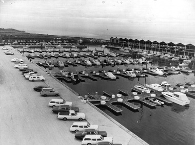
Photograph - Photograph of foreshore, Beaver Photographics, Mid winter boating from St Kilda marina, 6/07/1969
... Mid winter boating from St Kilda marina...St Kilda Marina...Label on back: Mid Winter Boating from St Kilda marina. Photograph taken Sunday 6th July 1969 Stamp: Beaver 31 Langhorne St., Dandenong, Aust. ...St Kilda Marina Label on back: Mid Winter Boating from St Kilda marina. ...Original mounted photographLabel on back: Mid Winter Boating from St Kilda marina. Photograph taken Sunday 6th July 1969 Stamp: Beaver 31 Langhorne St., Dandenong, Aust. For reprints please quote file no. 791-7888 File No 353-72st kilda marina -
 St Kilda Historical Society
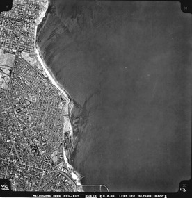
Photograph - Photo map, 08/02/1966
... St Kilda...St Kilda marina...St Kilda Historical Society St Kilda Branch Library 150 Carlisle Street St Kilda melbourne One of a series of photo-maps produced for the Department of Crown Lands and Survey (1857-1983). For correlation with a current map, and access to other historical photo maps of Victoria, see the Historic Photo-Maps Index published by the Department of Environment, Land, Water and Planning at https://services.land.vic.gov.au/DELWPmaps/historical-photomaps/ St Kilda St Kilda marina St Kilda beach Point Ormond Elwood Elwood beach Elwood park 1966 Vic 1916 Melbourne 1966 Project Run 13 E 8.2.66 Lens 122 151.75MM 9.800 113 Black and white aerial photograph Photograph Photo map ...One of a series of photo-maps produced for the Department of Crown Lands and Survey (1857-1983). For correlation with a current map, and access to other historical photo maps of Victoria, see the Historic Photo-Maps Index published by the Department of Environment, Land, Water and Planning at https://services.land.vic.gov.au/DELWPmaps/historical-photomaps/Black and white aerial photographVic 1916 Melbourne 1966 Project Run 13 E 8.2.66 Lens 122 151.75MM 9.800 113st kilda, st kilda marina, st kilda beach, point ormond, elwood, elwood beach, elwood park, 1966 -
 St Kilda Historical Society
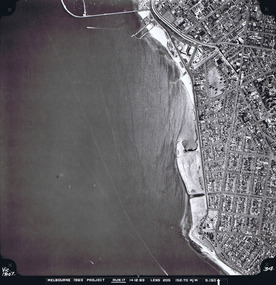
Photograph - Photo map, 14/12/1963
... St Kilda...Peanut farm...Point Ormond...St Kilda marina...St Kilda Historical Society St Kilda Branch Library 150 Carlisle Street St Kilda melbourne One of a series of photo-maps produced for the Department of Crown Lands and Survey (1857-1983). For correlation with a current map, and access to other historical photo maps of Victoria, see the Historic Photo-Maps Index published by the Department of Environment, Land, Water and Planning at https://services.land.vic.gov.au/DELWPmaps/historical-photomaps/ St Kilda Peanut farm Point Ormond St Kilda marina St Kilda pier 1963 Vic 1807 Melbourne 1963 Project Run 17 14.12.63 Lens 205 152,70 M/M 5.150 34 Black and white aerial photograph Photograph Photo map ...One of a series of photo-maps produced for the Department of Crown Lands and Survey (1857-1983). For correlation with a current map, and access to other historical photo maps of Victoria, see the Historic Photo-Maps Index published by the Department of Environment, Land, Water and Planning at https://services.land.vic.gov.au/DELWPmaps/historical-photomaps/Black and white aerial photographVic 1807 Melbourne 1963 Project Run 17 14.12.63 Lens 205 152,70 M/M 5.150 34st kilda, peanut farm, point ormond, st kilda marina, st kilda pier, 1963 -
 St Kilda Historical Society
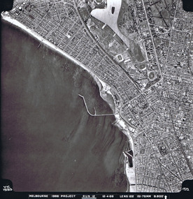
Photograph - Photo map, 12/04/1966
... St Kilda...St Kilda pier...St Kilda marina...St Kilda Historical Society St Kilda Branch Library 150 Carlisle Street St Kilda melbourne One of a series of photo-maps produced for the Department of Crown Lands and Survey (1857-1983). For correlation with a current map, and access to other historical photo maps of Victoria, see the Historic Photo-Maps Index published by the Department of Environment, Land, Water and Planning at https://services.land.vic.gov.au/DELWPmaps/historical-photomaps/ St Kilda St Kilda pier St Kilda marina Albert Park Fawkner Park Windsor South Yarra Prahran St Kilda West Middle Park St Kilda beach 1966 Vic 1933 Melbourne 1966 Project Run 12 12.4.66 Lens 122 151.75MM 9.800 152 Black and white aerial photograph Photograph Photo map ...One of a series of photo-maps produced for the Department of Crown Lands and Survey (1857-1983). For correlation with a current map, and access to other historical photo maps of Victoria, see the Historic Photo-Maps Index published by the Department of Environment, Land, Water and Planning at https://services.land.vic.gov.au/DELWPmaps/historical-photomaps/Black and white aerial photographVic 1933 Melbourne 1966 Project Run 12 12.4.66 Lens 122 151.75MM 9.800 152st kilda, st kilda pier, st kilda marina, albert park, fawkner park, windsor, south yarra, prahran, st kilda west, middle park, st kilda beach, 1966 -
 St Kilda Historical Society
Photograph - Photo map, 11/01/1968
... ...St Kilda Marina...St Kilda Historical Society St Kilda Branch Library 150 Carlisle Street St Kilda melbourne One of a series of photo-maps produced for the Department of Crown Lands and Survey (1857-1983). For correlation with a current map, and access to other historical photo maps of Victoria, see the Historic Photo-Maps Index published by the Department of Environment, Land, Water and Planning at https://services.land.vic.gov.au/DELWPmaps/historical-photomaps/ Elwood Elwood Park Elwood Canal Elwood beach St Kilda Marina MC Moran Reserve Point Ormond 1968 Vic 2132 State Aerial Survey Melbourne 1968 Proj. ...One of a series of photo-maps produced for the Department of Crown Lands and Survey (1857-1983). For correlation with a current map, and access to other historical photo maps of Victoria, see the Historic Photo-Maps Index published by the Department of Environment, Land, Water and Planning at https://services.land.vic.gov.au/DELWPmaps/historical-photomaps/Black and white aerial photographVic 2132 State Aerial Survey Melbourne 1968 Proj. Run 29E 11.1.68 5100 ASL 196elwood, elwood park, elwood canal, elwood beach, st kilda marina, mc moran reserve, point ormond, 1968 -
 St Kilda Historical Society
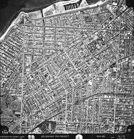
Photograph - Photo map, Department of Crown Lands and Survey (1857-1983), 22/01/1970
... St Kilda...St Kilda East...St Kilda Marina...St Kilda Historical Society St Kilda Branch Library 150 Carlisle Street St Kilda melbourne One of a series of photo-maps produced for the Department of Crown Lands and Survey (1857-1983). For correlation with a current map, and access to other historical photo maps of Victoria, see the Historic Photo-Maps Index published by the Department of Environment, Land, Water and Planning at https://services.land.vic.gov.au/DELWPmaps/historical-photomaps/ St Kilda St Kilda East St Kilda Marina Elwood Elwood canal Elsternwick Park Point Ormond Balaclava MC Moran Reserve Ripponlea St Kilda Botanical Gardens Peanut farm 1970 Vic 2358 Department of Crown Lands and Survey Victoria,.© Melbourne 1970 Project Run 42E 22.1.70 5,100 ASL 77 Black and white aerial photograph Photograph Photo map Department of Crown Lands and Survey (1857-1983) ...One of a series of photo-maps produced for the Department of Crown Lands and Survey (1857-1983). For correlation with a current map, and access to other historical photo maps of Victoria, see the Historic Photo-Maps Index published by the Department of Environment, Land, Water and Planning at https://services.land.vic.gov.au/DELWPmaps/historical-photomaps/Black and white aerial photographVic 2358 Department of Crown Lands and Survey Victoria,.© Melbourne 1970 Project Run 42E 22.1.70 5,100 ASL 77st kilda, st kilda east, st kilda marina, elwood, elwood canal, elsternwick park, point ormond, balaclava, mc moran reserve, ripponlea, st kilda botanical gardens, peanut farm, 1970 -
 St Kilda Historical Society
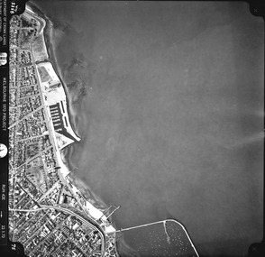
Photograph - Photo map, Department of Crown Lands and Survey, 22/01/1970
... St Kilda...St Kilda beach...St Kilda marina...St Kilda Historical Society St Kilda Branch Library 150 Carlisle Street St Kilda melbourne One of a series of photo-maps produced for the Department of Crown Lands and Survey (1857-1983). For correlation with a current map, and access to other historical photo maps of Victoria, see the Historic Photo-Maps Index published by the Department of Environment, Land, Water and Planning at https://services.land.vic.gov.au/DELWPmaps/historical-photomaps/ St Kilda St Kilda beach St Kilda marina Point Ormond St Kilda pier 1970 Vic 2358 Department of Crown Lands and Survey Victoria,.© Melbourne 1970 Project Run 42E 22.1.70 5,100 ASL 75 Black and white aerial photograph Photograph Photo map Department of Crown Lands and Survey ...One of a series of photo-maps produced for the Department of Crown Lands and Survey (1857-1983). For correlation with a current map, and access to other historical photo maps of Victoria, see the Historic Photo-Maps Index published by the Department of Environment, Land, Water and Planning at https://services.land.vic.gov.au/DELWPmaps/historical-photomaps/Black and white aerial photographVic 2358 Department of Crown Lands and Survey Victoria,.© Melbourne 1970 Project Run 42E 22.1.70 5,100 ASL 75st kilda, st kilda beach, st kilda marina, point ormond, st kilda pier, 1970 -
 Vision Australia
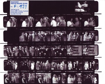
Image, 1992
... In one set, Marina Prior and Santa launch the Carols ticket sales, whilst in the other a group of people stand outside RVIB St Kilda Road building, with glasses in their hands. ...In one set, Marina Prior and Santa launch the Carols ticket sales, whilst in the other a group of people stand outside RVIB St Kilda Road building, with glasses in their hands. ...These proof sets cover the launch of Carols by Candlelight. In one set, Marina Prior and Santa launch the Carols ticket sales, whilst in the other a group of people stand outside RVIB St Kilda Road building, with glasses in their hands. Rhonda Burchmore and Geoff Harvey smile and laugh for cameras.2 x B/W proof sheets from the 1992 Carols by Candlelight launchcarols by candlelight, marina prior, rhonda burchmore, geoff harvey