Showing 84 items matching "state infrastructure"
-
 Bendigo Historical Society Inc.
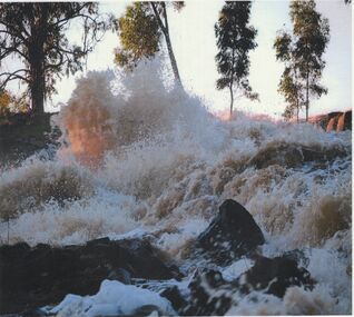
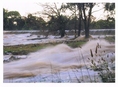
Photograph - HUGH ENNES COLLECTION: EPPALOCK WEIR WATER OVERFLOW - JAN 2011
... STATE INFRASTRUCTURE...History House 11 Mackenzie Street Bendigo goldfields STATE INFRASTRUCTURE Water supply coliban system The Hugh Ennes collection. ...The Hugh Ennes collection. Colour photograph. Water overflows from Eppalock Weir, January 2011.state infrastructure, water supply, coliban system -
 Bendigo Historical Society Inc.
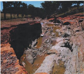
Photograph - HUGH ENNES COLLECTION: EPPALOCK WEIR WATER OVERFLOW - JAN 2011
... STATE INFRASTRUCTURE...History House 11 Mackenzie Street Bendigo goldfields STATE INFRASTRUCTURE Water supply coliban system The Hugh Ennes collection. ...The Hugh Ennes collection. Colour photograph. Erosion after water overflows from Eppalock Weir, January 2011. There are two copies of thios photo.state infrastructure, water supply, coliban system -
 Bendigo Historical Society Inc.
Photograph - HUGH ENNES COLLECTION: EPPALOCK WEIR WATER OVERFLOW - JAN 2011
... STATE INFRASTRUCTURE...History House 11 Mackenzie Street Bendigo goldfields STATE INFRASTRUCTURE Water supply coliban system The Hugh Ennes collection. ...The Hugh Ennes collection. Colour photograph. Erosion after water overflows from Eppalock Weir, January 2011.state infrastructure, water supply, coliban system -
 Bendigo Historical Society Inc.
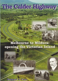
Book - THE CALDER HIGHWAY, 2006
... STATE INFRASTRUCTURE...History House 11 Mackenzie Street Bendigo goldfields STATE INFRASTRUCTURE Water Supply calder highway Calder Highway infrastructure Howard A. ...The Calder Highway - Melbourne to Mildura: opening the Victorian Inland. 128 pages with photos and illustrations, maps. Inscribed on fly page ' to Jim Evans with my thanks, Howard Carr'Howard A. Carrstate infrastructure, water supply, calder highway, calder highway, infrastructure -
 Bendigo Historical Society Inc.
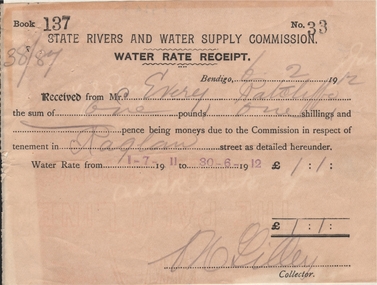
Document - FRANK J EVERY COLLECTION: STATE RIVERS AND WATER SUPPLY COMMISSION WATER RATE RECEIPT
... STATE INFRASTRUCTURE...History House 11 Mackenzie Street Bendigo goldfields STATE INFRASTRUCTURE Water supply State Rivers and Water Supply Commission State Rivers and Water Supply Commission - Water Rate Receipt. ...State Rivers and Water Supply Commission - Water Rate Receipt. Bendigo 06/02/1912, received from Mr Every the sum of one pound one shilling being moneys due to the commission in respect of tenement in Raglan street as detailed hereunder. Water rate from 1-7-1911 to 30-6-1912. Signed by a Mr Lilley (Collector).state infrastructure, water supply, state rivers and water supply commission -
 Bendigo Historical Society Inc.
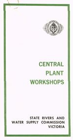
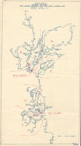
Document - STATE RIVERS AND WATER SUPPLY COMMISSION VICTORIA : CENTRAL PLANT WORKSHOPS
... STATE INFRASTRUCTURE...History House 11 Mackenzie Street Bendigo goldfields STATE INFRASTRUCTURE Water supply coliban system State Rivers and Water Supply Commission of Victoria. ...State Rivers and Water Supply Commission of Victoria. Brochure titled 'Central Plant Workshops'. Double-sided, three pages on each. Information about the workshops (CPW for short) and the setting up of the Bendigo site from 1946. There is a map of the layout of the site, and information given under the following headings - Central Plant Workshops, Work of the CPW, Meter Wheels, Pump Station Equipment, Steel Fabrication, Precast Concrete, and the Area and its Equipment. The brochure is dated June, 1968.state infrastructure, water supply, coliban system, state rivers and water supply commission of victoria. coliban system. central plant workshops. -
 Bendigo Historical Society Inc.
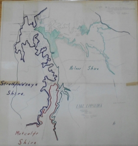
Map - STATE RIVERS AND WATER SUPPLY COMMISSION : LAKE EPPALOCK
... STATE INFRASTRUCTURE...History House 11 Mackenzie Street Bendigo goldfields STATE INFRASTRUCTURE Water supply coliban system State Rivers and Water Supply Commission of Victoria. ...State Rivers and Water Supply Commission of Victoria. Coliban System. Lake Eppalock. Map of Lake Eppalock foreshore area. Colour is used to delineate the areas of the Lake included in the three councils - McIvor Shire, Metcalf Shire and Strathfieldsaye Shire. Scale is 1 inch = 40 chains. Various notations in pencil have been added, with 'Coliban Office Plan' written and circled in the top right corner. A coloured (green) area is scaled as 'fore shore area in the charge of Derrinal Recreational Area Management Committee'. Individual leasing details have been added. state infrastructure, water supply, coliban system, state rivers and water supply commission of victoria. coliban system. lake eppalock. -
 Bendigo Historical Society Inc.
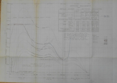
Document - STATE RIVERS AND WATER SUPPLY COMMISSION : COLIBAN SYSTEM CRITICAL STORAGE CURVES
... STATE INFRASTRUCTURE...History House 11 Mackenzie Street Bendigo goldfields STATE INFRASTRUCTURE Water supply coliban system State Rivers and Water Supply Commission of Victoria. ...State Rivers and Water Supply Commission of Victoria. Coliban System. Construction of Lake Eppalock. Chart titled 'Coliban System Critical Storage Curves'. Includes table headed ' Estimated requirements for various degrees of restricted consumption' related to the demand on the Coliban River. Figures on storages of Upper Coliban, Lauriston, Malmsbury, Barkers Creek, and Spring Gully. There are penciled notations added. The information appears to be for the years 1957/58/59. state infrastructure, water supply, coliban system, state rivers and water supply commission of victoria. coliban system. lake eppalock. -
 Bendigo Historical Society Inc.
Document - STATE RIVERS AND WATER SUPPLY COMMISSION : 1964-1965 A YEAR OF ACHIEVEMENT, 30/05/1965
... STATE INFRASTRUCTURE...History House 11 Mackenzie Street Bendigo goldfields STATE INFRASTRUCTURE Water supply coliban system State Rivers and Water Supply Commission of Victoria. ...State Rivers and Water Supply Commission of Victoria. Small brochure titled '1964-1965 A Year of Achievement'. Contains information headed 'Rural Water Assets as at 30th June, 1965' and 'Highlights of 1964/5'. Also contains information about the purpose and work of the Commission as well as an answer to the question - Why do you pay rates? People mentioned in the brochure : The Minister - the Hon. T. A. Darcy, M.L.A.; The Commission - A.L. Tisdall, Chairman; R.A. Horsfall, Deputy Chairman; K.D. Green, Commissioner; The Secretary - G. W. V. Lewis.state infrastructure, water supply, coliban system, state rivers and water supply commission of victoria. -
 Bendigo Historical Society Inc.
Document - STATE RIVER AND WATER SUPPLY COMMISSION : STEEL PIPELINES DESIGN
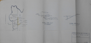
... STATE INFRASTRUCTURE...History House 11 Mackenzie Street Bendigo goldfields STATE INFRASTRUCTURE Water supply coliban system State Rivers and Water Supply Commission. ...State Rivers and Water Supply Commission. Coliban System. Lake Eppalock construction. Steel Pipelines Design. Cardboard folder, foolscap size, containing fifteen pages of typed notes, stapled into the folder. Includes diagrams on thicker paper. On the front of the folder is a handwritten note ' Steel Pipelines Design Notes compiled by F. G. Long'. The notes inside are titled ‘Steel Pipe Lines' and 'Pipe Shell'.state infrastructure, water supply, coliban system, state rivers and water supply commission. coliban system. lake eppalock. -
 Bendigo Historical Society Inc.
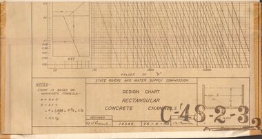
Document - STATE RIVERS AND WATER SUPPLY COMMISSION : DESIGN CHART RECTANGULAR CONCRETE CHANNELS
... STATE INFRASTRUCTURE...History House 11 Mackenzie Street Bendigo goldfields STATE INFRASTRUCTURE Water supply coliban system State Rivers and Water Supply Commission. ...State Rivers and Water Supply Commission. Coliban System. Lake Eppalock construction. Design chart of Rectangular Concrete Channels (42cm x 63.5cm) is stamped C-'48-2-3. Attached is a page labelled Open Channel Flow Diagram (33cm x 42cm), stamped C-'49-2-3.state infrastructure, water supply, coliban system, state rivers and water supply commission. coliban system. lake eppalock. -
 Bendigo Historical Society Inc.
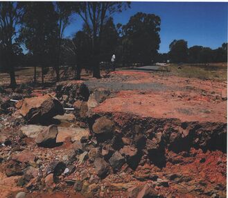
Photograph - HUGH ENNES COLLECTION: EPPALOCK WEIR WATER OVERFLOW - JAN 2011
... STATE INFRASTRUCTURE...History House 11 Mackenzie Street Bendigo goldfields STATE INFRASTRUCTURE Water supply coliban system Eppalock Weir. ...The Hugh Ennes collection. Colour photograph. Water overflows from Eppalock Weir, January 2011.state infrastructure, water supply, coliban system, eppalock weir. coliban system. -
 Bendigo Historical Society Inc.
Document - STATE RIVERS AND WATER SUPPLY COMMISSION : KIMBOLTON RECREATIONAL AREA SEWERAGE PLAN
... STATE INFRASTRUCTURE...History House 11 Mackenzie Street Bendigo goldfields STATE INFRASTRUCTURE Water supply coliban system Eppalock State Rivers and Water Supply Commission. ...State Rivers and Water Supply Commission. Eppalock Project. Plan document titled: Kimbolton Recreational Area Committee. Sewerage of 'C' Section club sites. Rising Mains. Number 101378A is in bottom right corner. Diagrams: Detail pipe inlet at Lagoons, Detail pipe outlet. Plan scale: 1 inch = 6 chns. state infrastructure, water supply, coliban system, eppalock -
 Bendigo Historical Society Inc.
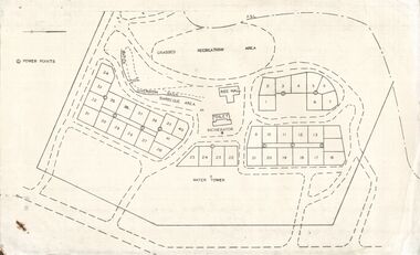
Document - STATE RIVERS AND WATER SUPPLY COMMISSION : EPPALOCK RECREATIONAL AREA PLAN?
... STATE INFRASTRUCTURE...History House 11 Mackenzie Street Bendigo goldfields STATE INFRASTRUCTURE Water supply coliban system State Rivers and Water Supply Commission. ...Photocopied plan of power points for a recreational area, possibly Eppalock foreshore recreational area?. No title, and undated. With other Eppalock documents.state infrastructure, water supply, coliban system, state rivers and water supply commission. coliban system. eppalock. -
 Bendigo Historical Society Inc.
Document - STATE RIVERS AND WATER SUPPLY COMMISSION : EPPALOCK PROJECT - CONSTRUCTION
... STATE INFRASTRUCTURE...History House 11 Mackenzie Street Bendigo goldfields STATE INFRASTRUCTURE Water supply coliban system State Rivers and Water Supply Commission. ...State Rivers and Water Supply Commission headed six page document, stapled. Subtitled: ' Eppalock Project - Construction. Some Technical Notes.' Information typed under subheadings: Dam, Embankment, Spillways, Outlet works, proposed hydraulic driven pumps, road deviations. Undated.state infrastructure, water supply, coliban system, state rivers and water supply commission. coliban system. eppalock. -
 Bendigo Historical Society Inc.
Document - STATE RIVERS AND WATER SUPPLY COMMISSION : GENERAL DESCRIPTION AND PARTICULARS OF EPPALOCK PROJECT, 1/08/1961
... STATE INFRASTRUCTURE...History House 11 Mackenzie Street Bendigo goldfields STATE INFRASTRUCTURE Water supply coliban system State Rivers and Water Supply Commission. ...State Rivers and Water Supply Commission. Seven-page typed document titled 'General description and particulars of the Eppalock Project.' Subheadings: General, Administration and Works Installation, Field laboratory, Construction programme, Design statistics, Major items of plant in use on the project, Progress to 1st August 1961, Eppalock Reservoir Locality Plan (diagram), Eppalock project works area & arrangement plan (diagram), Eppalock Project cross section of dam along? tunnel (diagram).state infrastructure, water supply, coliban system, state rivers and water supply commission. coliban system. eppalock. -
 Bendigo Historical Society Inc.
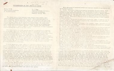
Document - STATE RIVERS AND WATER SUPPLY COMMISSION : DETERMINATION OF IONIC SPECIES IN WATER, Sept, 1974
... STATE INFRASTRUCTURE...History House 11 Mackenzie Street Bendigo goldfields STATE INFRASTRUCTURE Water supply coliban system State Rivers and Water Supply Commission. ...State River and Water Supply Commission. Two page photocopy of an article titled ' Determination of Ionic Species in Water. Project 70/188 Water Research of Australia Limited. Dr. J. Bagg, Department of Industrial Science, University of Melbourne, Parkville, Victoria 3052.' Across the top is written, in pencil, W.R.F. of A. Report No 38, Number 141, Sept 74.state infrastructure, water supply, coliban system, state rivers and water supply commission. coliban system. -
 Bendigo Historical Society Inc.
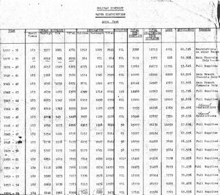
Document - STATE RIVERS AND WATER COMMISSION : COLIBAN DISTRICT WATER DISTRIBUTION ACRE FEET
... STATE INFRASTRUCTURE...History House 11 Mackenzie Street Bendigo goldfields STATE INFRASTRUCTURE Water supply coliban system State Rivers and Water Supply Commission. ...A table titled Coliban District Water Distribution Acre Feet. The dates indicated cover the period 1937-1957. Main column headings: Urban Supplies, Irrigation, Sluicing, Total Consumption, Total Deliveries from Storages, Loss, Efficiency, and Remarks. Years and figures are typed in red columns with some figures totalled in pencil at the bottom of the last column.state infrastructure, water supply, coliban system, state rivers and water supply commission. coliban system. -
 Bendigo Historical Society Inc.
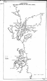
Map - STATE RIVERS AND WATER COMMISSION : COLIBAN DISTRICT IRRIGATION AND TOWN SUPPLY CHANNELS, 30/11/1956
... STATE INFRASTRUCTURE...History House 11 Mackenzie Street Bendigo goldfields STATE INFRASTRUCTURE Water supply coliban system State Rivers and Water Supply Commission. ...State Rivers and Water Supply Commission. Foolscap-size map. Title : Coliban district Plan showing Irrigation and Town Supply Channels. The map covers the area from Raywood to Guildford. Scale : 1 inch to 4 miles. Dated 30/11/56, number 5,491 in bottom right corner.state infrastructure, water supply, coliban system, state rivers and water supply commission. coliban system. -
 Bendigo Historical Society Inc.
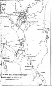
Map - STATE RIVERS AND WATER SUPPLY COMMISSION : COLIBAN SYSTEM OF WATERWORKS MAP
... STATE INFRASTRUCTURE...History House 11 Mackenzie Street Bendigo goldfields STATE INFRASTRUCTURE Water supply coliban system State Rivers and Water Supply Commission. ...State Rivers and Water Supply Commission. Photocopied foolscap-size map. Title: Coliban System of Waterworks. Channels, reservoirs, reticulation systems. Maldon - S.R. & W.S.C. reticulated towns. The map includes the areas from Goornong to south of Kyneton and across to Maldon: Goornong, Marong, Bendigo, Strathfieldsaye, Lockwood, Maldon, Harcourt, Castlemaine, Newstead, Elphinstone, Taradale, Malmsbury, Kyneton.state infrastructure, water supply, coliban system, state rivers and water supply commission. coliban system. -
 Bendigo Historical Society Inc.
Map - STATE RIVERS AND WATER SUPPLY COMMISSION : COLIBAN DISTRICT MAP 1956, 30/11/1956
... STATE INFRASTRUCTURE...History House 11 Mackenzie Street Bendigo goldfields STATE INFRASTRUCTURE Water supply coliban system State Rivers and Water Supply Commission. ...State Rivers and Water Supply Commission Coliban District map. Titled: S.R. & W.S.C. Coliban District Plan showing Irrigation and Town Supply Channels 1956. Scale: 1 inch = 4 miles. Indicates concrete lining and concrete re-lining channels. Printed in blue ink and information added in red. The map is dated at the bottom - 30/11/'56. There is a number, 25,491, in the bottom right corner.state infrastructure, water supply, coliban system, state rivers and water supply commission. coliban system. -
 Bendigo Historical Society Inc.
Document - STATE RIVERS AND WATER SUPPLY COMMISSION : THE COLIBAN SYSTEM OF WATERWORKS, July
... STATE INFRASTRUCTURE...History House 11 Mackenzie Street Bendigo goldfields STATE INFRASTRUCTURE Water Supply coliban system State Rivers and Water Supply Commission. ...Document titled State Rivers and Water Supply Commission: The Coliban System of Waterworks. Two typed foolscap pages. Three copies of this document - one with measurements in acre-feet, has 'seen July 1971' written in pencil on the top right corner. The other two copies appear to have been updated to convey information in mega litres. Subheadings: History, Development of main storages, Facts and figures, Headworks.state infrastructure, water supply, coliban system, state rivers and water supply commission. coliban system. -
 Bendigo Historical Society Inc.
Document - STATE RIVERS AND WATER SUPPLY COMMISSION : CONSTITUTION AND FUNCTIONS
... STATE INFRASTRUCTURE...History House 11 Mackenzie Street Bendigo goldfields STATE INFRASTRUCTURE Water Supply coliban system State Rivers and Water Supply Commission. ...State Rivers and Water Supply Commission. Five page typed foolscap document, stapled, outlining the organisation's constitution and functions. The specific functions mentioned include Storage, Irrigation, Drainage - Flood Protection, Town Water Supply - Trust and Urban, Sewerage, Control, Crown's Rights, 1969 Groundwater Act, River Gauging’s, Survey and Research, Finance, Overseas Work, and Payroll (3500 employees). The document is undated, though some of the statistics given are from 1969.state infrastructure, water supply, coliban system, state rivers and water supply commission. coliban system. -
 Melbourne Tram Museum
Document - Digital Image, Victorian Transport Action Group (VTAG), "Melbourne’s Tram Plan Response Filling the Gaps", March 2024
... Direct Infrastructure Victoria to undertake the specific planning process as part of the next state infrastructure plan to canvas a range of possible network enhancements. 4. ...Direct Infrastructure Victoria to undertake the specific planning process as part of the next state infrastructure plan to canvas a range of possible network enhancements. 4. ...Document produced by the Victorian Transport Action Group as a response to the Department of Transport "Melbourne Tram Plan" of Oct. 2023 - see item 7364. VTAG have produced a number of initiatives and looks at a number of route proposals that have been made by Government but as of the end of 2024, little progress has been made on any of them. Initiatives suggested are: 1. Confirm its commitment to previously announced projects (listed in Table 1) and provide indicative timeframes for completion. 2. Redirect routes 3, 5 and 12 (detailed in Table 2) with the opening of MM1 to improve the distribution of tram services through the central area. 3. Direct Infrastructure Victoria to undertake the specific planning process as part of the next state infrastructure plan to canvas a range of possible network enhancements. 4. Revise the selection of stops for upgrade to level access to include the practical considerations of technical feasibility and constructability to ensure that as many stops as possible are delivered as a priority. 5. Expand the corridor-based approach being applied to upgrade stops to include the implementation of traffic priority along the selected corridors. 6. Adopt a 15mins, or at least 20 mins, as the maximum headway for all Melbourne tram routes. Notes changes that will be needed as a result of the Melbourne Metro in 2025, tram stops, energy efficiency, renewing the fleet and infrastructure, network performance, and passenger experience. Demonstrates a response to the Vic Govt's tram plan by an Action Group.Digital copy of a 21 A4 page document produced by the Victorian Transport Action Group March 2024. tramways, victorian government, department of transport, planning, vtag -
 Bendigo Historical Society Inc.
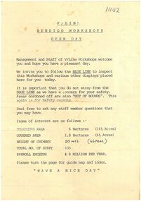
Ephemera - V/Line Bendigo workshops 'Open Day' leaflet
... The workshops were redeveloped in 2002 at a cost of $6.5 million - $4 million from VicTrack, $2 million from the State Government Regional Infrastructure Development Fund and $500,000 by the City of Greater Bendigo. ...The workshops were redeveloped in 2002 at a cost of $6.5 million - $4 million from VicTrack, $2 million from the State Government Regional Infrastructure Development Fund and $500,000 by the City of Greater Bendigo. ...The workshops were opened in November 1917 by the Victorian Railways. It opened in response to political pressures from provincial groups for decentralisation, with the Victorian Railways preferring the cheaper option of expanding the existing Newport Workshops in suburban Melbourne. Furthermore, unemployment had risen in both Bendigo and Ballarat due to a decline in mining operations. The main work carried out was repairs and maintenance of existing wagons and locomotives, however during 1919-22 thirteen new steam locomotives were also built - eight DD class (1033 - 1037, 1047 - 1049) and five A2 class (1078 - 1082). From the 1950s onwards, numerous steam locomotives were scrapped at the workshops. During the years immediately following nominal dieselisation in 1968, they were, at times, cutting up locomotives at the rate of one every two to three weeks. The workshops were also the site of the first VR brass foundry, which was transferred to Newport by the 1960s. Also, throughout 1965, VLX louvred vans were constructed at the workshops, at a rate of one a week. Other tasks included spring manufacture, construction of stainless steel footwarmers, and assembly of pantographs for electric trains, with a staff of 720 employed during 1966. By the 1980s, refurbishment work was also being carried out on Melbourne suburban electric multiple units. The 1980s were also a time of restructuring, and on the breakup of the Victorian Railways the workshops passed to the State Transport Authority and then the Public Transport Corporation. With privatisation the workshops were closed, with the loss of 262 jobs. In February 1996, the workshops were taken over by A Goninan & Co. In October 1999 the workshops were purchased by Great Northern Rail Services, with A Goninan & Co remaining as a tenant. In February 2001 A Goninan & Co vacated the site. The workshops were redeveloped in 2002 at a cost of $6.5 million - $4 million from VicTrack, $2 million from the State Government Regional Infrastructure Development Fund and $500,000 by the City of Greater Bendigo. The Bendigo Rail Workshops at North Bendigo are currently used by Southern Shorthaul Railroad to maintain broad gauge rolling stock for Pacific National, V/Line, Metro Trains Melbourne and CFCLA.Typed document. A4 page folded in half. On tan paper. Document pertaining to Bendigo V/Line workshops open day. Map on inside of folded page. Undated document.train, v/line, workshops, open day -
 Kiewa Valley Historical Society
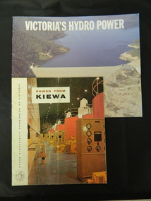
Booklets - Kiewa Hydro Electric Scheme, 1. "Power From Kiewa" and 2. "Victoria's Hydro Power", 1. Made in July 1968 and 2. Made in Aug. 1985
... The State Electricity Commission of Victoria built the Kiewa Hydro Electric Scheme establishing infrastructure such as the Bogong and Mt Beauty townships and the opportunity for tourism in the area. state electricity commission of victoria; kiewa hydro electric scheme; victoria's hydro electric power; kiewa; mckay creek power station; clover power station; west kiewa power station 1. ...1. The State Electricity Commission of Victoria built the Kiewa Hydro Electric Scheme from the 1930's to the 1960's. This booklet was to inform visitors and to promote tourism. 2. The State Electricity Commission built several hydro power stations from 1928 - 1981. This booklet names each with a summary and explanation.The State Electricity Commission of Victoria built the Kiewa Hydro Electric Scheme establishing infrastructure such as the Bogong and Mt Beauty townships and the opportunity for tourism in the area.1. Colored soft cover with photo of McKay Creek Power Station on the front and Mt Beauty township on the back. Published by the SECV 2. Colored soft cover with Rocky Valley Dam on the front and inserted photo of a stream and snow on the back. Published by the SEC.state electricity commission of victoria; kiewa hydro electric scheme; victoria's hydro electric power; kiewa; mckay creek power station; clover power station; west kiewa power station -
 Kiewa Valley Historical Society
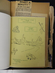
Folder - Bogong High Plains and Falls Creek, 1960's and 1970's
... Kiewa Valley Historical Society Mount Beauty Information Centre 31 Bogong High Plains Rd Mt Beauty high-country Tourism on the Bogong High Plains developed after/during the State Electricity Commission of Victoria construction of the Kiewa Hydro Electric Scheme. With the completion of the power stations on the Bogong High plains, tourism has created a new focus and different infrastructure/lifestyle for the community. ...Tourism on the Bogong High Plains developed after/during the State Electricity Commission of Victoria construction of the Kiewa Hydro Electric Scheme.With the completion of the power stations on the Bogong High plains, tourism has created a new focus and different infrastructure/lifestyle for the community.A blue folder with a collection of papers & booklets on: 1. Discovery of Bogong High Plains 1962 2. SECV Discovery of Bogong High Plains 1968 3. SECV Kiewa Hydro Electric Scheme 1911 - 1961 4. Newspaper cutting - Mt Beauty 1974 5. McKay Creek Power Station and Clover Power Station 6. Falls Creek and Mt Beauty Tourist Map & brochures 7. Bogong High Plains Tour 1973bogong high plains; falls creek; tourism; -
 Kiewa Valley Historical Society
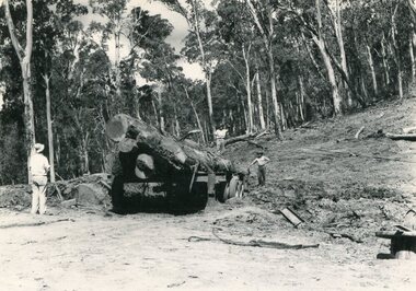
Photo - Mountain Creek Logging Camp, 1955
... The logs could have been milled for timber at the State Electricity Commission's mill at Howman's Gap which provided a much needed source of timber for construction of McKay Creek Power Station which began construction in 1951 and also the camps and houses for the workers and their families. There was a need for housing and infrastructure...The logs could have been milled for timber at the State Electricity Commission's mill at Howman's Gap which provided a much needed source of timber for construction of McKay Creek Power Station which began construction in 1951 and also the camps and houses for the workers and their families. There was a need for housing and infrastructure ...Hume and Hovell discovered the area in 1824 and by the end of the 19th century the valley was transformed by logging, dairy and beef cattle properties and tobacco farms. The logs could have been milled for timber at the State Electricity Commission's mill at Howman's Gap which provided a much needed source of timber for construction of McKay Creek Power Station which began construction in 1951 and also the camps and houses for the workers and their families. There was a need for housing and infrastructure for an increasing population of workers for the hydro-electric scheme as there was a general shortage of this commodity. A timber mill was started in Tawonga by Mates, of Albury, in 1945, and electricity became available in 1946 the S.E.C. bought the mill, and enlarged it. In 1960 it was purchase by a local family, they also started a timber mill in Mt Beauty worked both until 1980 when they closed it. The Tawonga mill and enlarged the mill called Mt. Beauty Timbers Pty Ltd employed approximately 50 people. An historical pictorial record of the general working conditions, type of machinery and vehicles in use in the 1950’s. Note the lack of protective clothing!Black and white photograph of the logging camp at Mountain Creek. November 1955Handwritten on the back of photograph - MOUNTAIN CREEK LOGGING CAMP NOV 55mountain creek logging camp, timber industry, tawonga -
 Kiewa Valley Historical Society
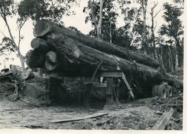
Photo - Logging. Mountain Creek, November 1955, November 1955
... The logs could have been milled for timber at the State Electricity Commission's mill at Howman's Gap which provided a much needed source of timber for construction of McKay Creek Power Station which began construction in 1951 and also the camps and houses for the workers and their families. There was a need for housing and infrastructure...The logs could have been milled for timber at the State Electricity Commission's mill at Howman's Gap which provided a much needed source of timber for construction of McKay Creek Power Station which began construction in 1951 and also the camps and houses for the workers and their families. There was a need for housing and infrastructure ...Hume and Hovell discovered the area in 1824 and by the end of the 19th century the valley was transformed by logging, dairy and beef cattle properties and tobacco farms. The logs could have been milled for timber at the State Electricity Commission's mill at Howman's Gap which provided a much needed source of timber for construction of McKay Creek Power Station which began construction in 1951 and also the camps and houses for the workers and their families. There was a need for housing and infrastructure for an increasing population of workers for the hydro-electric scheme as there was a general shortage of this commodity. A timber mill was started in Tawonga by Mates, of Albury, in 1945, and electricity became available in 1946 the S.E.C. bought the mill, and enlarged it. In 1960 it was purchase by a local family, they also started a timber mill in Mt Beauty worked both until 1980 when they closed it. The Tawonga mill and enlarged the mill called Mt. Beauty Timbers Pty Ltd employed approximately 50 people An historical pictorial record of the general working conditions, type of machinery and vehicles in use in the 1950’s. Black and white photograph of logging at Mountain Creek November 1955Small typed note attached to the back of photo - Logging Mountain Creek November 1955mountain creek logging camp, tawonga, timber industry -
 Kiewa Valley Historical Society
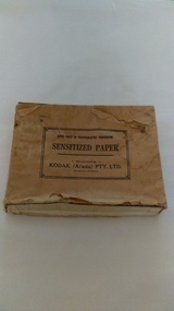
Photographs of small box originally used to contain sensitized photographic paper
... State Electricity Commission of Victoria. SECV official photographers took photographs of most stages of construction of the Hydro Electric Scheme and referenced each photo with a number and dating system as an historical record and for reference for other projects. This provided a thorough history of the construction of the Hydro Electric Scheme, some of the workers involved in its construction and the infrastructure ...The Junction Dam and Clover Dam Power Station, stages of the Kiewa Hydro-Electric Scheme, were needed to meet the increased power demands of the wartime industry in Victoria. Clover added 26 megawatts to the grid. Junction Dam was completed and ready to hold water by September 1943, but was emptied in December 1943 and not filled again until May 1944. Construction of Clover Power Station commenced in July 1941 and both turbines were in service by May 1945.Clover Power Station and Junction Dam were part of the Kiewa Hydro Electric Scheme constructed by the State Electricity Commission of Victoria. SECV official photographers took photographs of most stages of construction of the Hydro Electric Scheme and referenced each photo with a number and dating system as an historical record and for reference for other projects. This provided a thorough history of the construction of the Hydro Electric Scheme, some of the workers involved in its construction and the infrastructure supporting its construction, such a Bogong Village.Small light brown cardboard box originally containing sensitized photographic paper, now containing a range of black and white photographs of the Kiewa Hydro Electric System taken by the official SECV photographer Box has some damage – Front panel on lid is missing. Top has a puncture in top right corner and some peeling of paper along sides and at edges. Printed on the top of the box in black ink: OPEN ONLY IN PHOTOGRAPHIC DARK ROOM SENSITIZED PAPER Manufactured by – KODAK (A/asia) PTY. LTD. Melbourne Australia Green and white sticker on right side of lid and bottom right side of box, torn at join 1. 1B1 Single Weight Soft. Available in Soft (1) Medium (2) Contrast (3) Extra Contrast (4) Single and Double Weight Stamped at bottom of sticker in grey ink G8087 CK photographic paper box; state electricity commission of victoria; official photographer; kiewa hydro electric scheme; clover power station; junction dam; bogong village