Showing 17 items matching "stony creek bridge"
-
 Lakes Entrance Historical Society
Book, TRAM Engineering and Services Pty. Ltd, Inspection Report - Stony Creek Bridge - Bairnsdale-Orbost Rail Trail, 2001
... Inspection Report - Stony Creek Bridge - Bairnsdale-Orbost Rail Trail....A report on the condition of the Stony Creek Railway bridge, Gippsland, Victoria, as well as the work required to ensure the stability of the bridge and make it suitable for use as a footbridge....Inspection Report - Stony Creek Bridge - Bairnsdale-Orbost Rail Trail. ...A report on the condition of the Stony Creek Railway bridge, Gippsland, Victoria, as well as the work required to ensure the stability of the bridge and make it suitable for use as a footbridge.transport, bridges, engineering -
 Eltham District Historical Society Inc
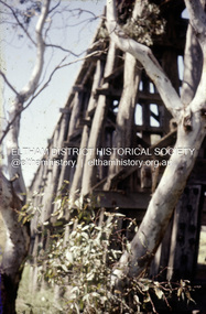
Slide, Russell Yeoman, Possibly Stony Creek Trestle bridge, c.1990
... Possibly Stony Creek Trestle bridge...Stony Creek...trestle bridge...Russell Yeoman Collection Scan - 35mm positive Film - Fuji Mount - Fuji Film grey white Stony Creek trestle bridge 35 mm colour positive transparency Mount - Fuji Film grey white Possibly Stony Creek Trestle bridge Slide Russell Yeoman ...35 mm colour positive transparency Mount - Fuji Film grey whiterussell yeoman collection, scan - 35mm positive, film - fuji, mount - fuji film grey white, stony creek, trestle bridge -
 Eltham District Historical Society Inc
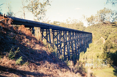
Photograph, Stony Creek Trestle bridge, 1990, 1990
... Stony Creek Trestle bridge, 1990...bridge...stony creek...Position on roll of film is immediately prior to unveiling of Walter Withers commemorative plaque in Walter Withers Reserve, Eltham. trestle bridge stony creek Fuji 100 N Roll of 35mm colour negative film, 1 strip Stony Creek Trestle bridge, 1990 Photograph ...A trestle bridge in comparison to Eltham's Railway Trestle Bridge. Position on roll of film is immediately prior to unveiling of Walter Withers commemorative plaque in Walter Withers Reserve, Eltham. Roll of 35mm colour negative film, 1 stripFuji 100 Ntrestle bridge, stony creek -
 Orbost & District Historical Society
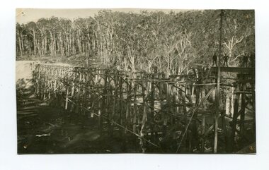
Photograph - Photograph. black + white
... ...stony creek bridge...The Stony Creek Trestle Bridge was built in 1916 when the existing rail line from Melbourne to Bairnsdale was extended to Orbost. ...Orbost & District Historical Society Ruskin Street Orbost gippsland The Stony Creek Trestle Bridge was built in 1916 when the existing rail line from Melbourne to Bairnsdale was extended to Orbost. ...The Stony Creek Trestle Bridge was built in 1916 when the existing rail line from Melbourne to Bairnsdale was extended to Orbost. This 97km Bairnsdale to Orbost extension through rugged terrain was reputed to have been the most difficult rail project undertaken in Victoria. In service for over 60 years the bridge was damaged by bushfire in 1980, with the last train crossing in 1987. At 247m long and 20m high, it is the largest standing bridge of its kind in the State, and is listed on the Register of Historic Sites. Built of red ironbark and grey box timber, it is a fine example of the early engineering skills that utilised the resources and materials found on site. (More information Newsletter July 2013)Built during the period 1914-16, of Gippsland Grey Box and Red Ironbark, the Stoney Creek bridge on the East Gippsland Railway is a fine example of early engineering skilll , being constructed without the aid of any of the modern machinery available today. This is a rare photograph and of high significance in showing the bridge under construction.Landscape format black + white photograph (unframed). Four pin holes in each corner, tear to top left quadrant and fold / crease top to bottom in centre of image.construction, 1916, railway bridge, timber industry, trestle construction, stony creek bridge, east gippsland, bairnsdale to orbost line -
Lakes Entrance Historical Society
Book, LERHS, Railway Bairnsdale to Orbost, VTF Project, 2015
... Information on the construction of the railway from Bairnsdale to Orbost, the stony creek, trestle bridge also plans for the very fast train from Melbourne to Sydney Lakes Entrance Victoria...Lakes Entrance Historical Society 4 Marine Parade Lakes Entrance gippsland Transport Bridges Information on the construction of the railway from Bairnsdale to Orbost, the stony creek, trestle bridge also plans for the very fast train from Melbourne to Sydney Lakes Entrance Victoria Railway Bairnsdale to Orbost, VTF Project Book LERHS ...Information on the construction of the railway from Bairnsdale to Orbost, the stony creek, trestle bridge also plans for the very fast train from Melbourne to Sydney Lakes Entrance Victoriatransport, bridges -
 Orbost & District Historical Society
black and white photograph, first half 20th century
... The Stony Creek Trestle Bridge was built in 1916 when the existing rail line from Melbourne to Bairnsdale was extended to Orbost. ...Orbost & District Historical Society Ruskin Street Orbost gippsland The Stony Creek Trestle Bridge was built in 1916 when the existing rail line from Melbourne to Bairnsdale was extended to Orbost. ...The Stony Creek Trestle Bridge was built in 1916 when the existing rail line from Melbourne to Bairnsdale was extended to Orbost. This 97km Bairnsdale to Orbost extension through rugged terrain was reputed to have been the most difficult rail project undertaken in Victoria. In service for over 60 years the bridge was damaged by bushfire in 1980, with the last train crossing in 1987. At 247m long and 20m high, it is the largest standing bridge of its kind in the State, and is listed on the Register of Historic Sites. Built of red ironbark and grey box timber, it is a fine example of the early engineering skills that utilised the resources and materials found on site.The Bairnsdale to Orbost rail line contains the most varied range of timber & timber composite bridges on any Victorian line. The Stoney Creek bridge is listed on the Victorian Heritage Register for its architectural and historical significance. A black / white photograph of a very tall wooden railway bridge with a train along the top.railway-bridge stoney-creek-bridge east-gippsland-railway -
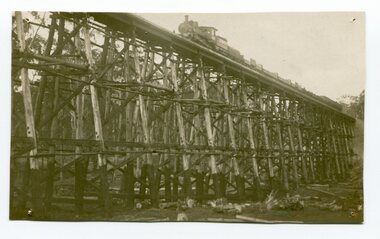 Orbost & District Historical Society
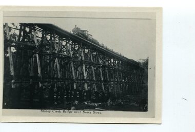
black and white photograph, 1977?
... In 1977 great efforts were being made to preserve this bridge, the highest trestle bridge in Victoria at Stoney Creek. The Stony Creek Trestle Bridge was built in 1916 when the existing rail line from Melbourne to Bairnsdale was extended to Orbost. ...Orbost & District Historical Society Ruskin Street Orbost gippsland In 1977 great efforts were being made to preserve this bridge, the highest trestle bridge in Victoria at Stoney Creek. The Stony Creek Trestle Bridge was built in 1916 when the existing rail line from Melbourne to Bairnsdale was extended to Orbost. ...In 1977 great efforts were being made to preserve this bridge, the highest trestle bridge in Victoria at Stoney Creek. The Stony Creek Trestle Bridge was built in 1916 when the existing rail line from Melbourne to Bairnsdale was extended to Orbost. This 97km Bairnsdale to Orbost extension through rugged terrain was reputed to have been the most difficult rail project undertaken in Victoria. In service for over 60 years the bridge was damaged by bushfire in 1980, with the last train crossing in 1987. At 247m long and 20m high, it is the largest standing bridge of its kind in the State, and is listed on the Register of Historic Sites. Built of red ironbark and grey box timber, it is a fine example of the early engineering skills that utilised the resources and materials found on site.The Bairnsdale to Orbost rail line contains the most varied range of timber & timber composite bridges on any Victorian line. The Stoney Creek bridge is listed on the Victorian Heritage Register for its architectural and historical significance.A black / white photograph of a very large trestle bridge. a steam locomotive, with loaded goods trucks, is on the bridge. stoney-creek trestle-bridge railway east-gippsland-railway -
 Eltham District Historical Society Inc
Photograph, Fay Bridge, Eastern boundary of former Warrandyte Aboriginal Reserve, North Warrandyte, 7 November 2016
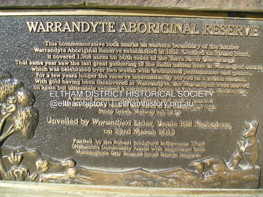
... Stony Creek. Melway ref : 23 C 9 Unveiled by Wurundjeri Elder, Uncle Bill Nicholson on 23rd March 2013 Funded by the Robert Bridgford Indigenous Trust (Nillumbik Community Fund) with assistance from Manningham City Council Small Grants Program Ref: Monument Autralia https://monumentaustralia.org.au/themes/culture/indigenous/display/99680-warrandyte-aboriginal-reserve- Fay Bridge Collection 2016-11-07 aboriginal reserve North Warrandyte Plaques Warrandyte Aboriginal Reserve 1 images - born digital Eastern boundary of former Warrandyte Aboriginal Reserve, North Warrandyte Photograph Photograph Fay Bridge ...Two bronze commemorative plaques on rocks, unveiled by Wurundjeri Tribe Council Elders, mark two eastern boundaries of the former Warrandyte Aboriginal Reserve on the north and south sides of the Yarra. This project was initiated by Nillumbik Reconciliation Group in close association with Reconciliation Manningham and the Wurundjeri Tribe Council, as a means of commemorating the last great corroboree of the Kulin Nation which was held at Pound Bend in March 1852. This plaque is on the Nillumbuk side of the Yarra, accessed via The Boulevard, North Warrandyte. The plaque is set on a rock approximately 50 metres before the turning circle at the end of The Boulevard. Plaque : Warrandyte Aboriginal Reserve This commemorative rock marks an eastern boundary of the former Warrandyte Aboriginal Reserve established in 1852. Centred on Pound Bend, it covered 1,908 acres on both sides of the Yarra River (Birrarung). That same year saw the last great gathering of the Kulin nation here in Wurundjeri country which was celebrated over two weeks with traditional performance and games. For a few years longer the reserve intermittently served as a ration station.With gold having been discovered at Warrandyte, the Wurundjeri were moved on again but ultimately secured a permanent home at Coranderrk, Healesville. A second commemorative plaque and rock is located on the opposite bank of the Yarra and its confluence with Stony Creek. Melway ref : 23 C 9 Unveiled by Wurundjeri Elder, Uncle Bill Nicholson on 23rd March 2013 Funded by the Robert Bridgford Indigenous Trust (Nillumbik Community Fund) with assistance from Manningham City Council Small Grants Program Ref: Monument Autralia https://monumentaustralia.org.au/themes/culture/indigenous/display/99680-warrandyte-aboriginal-reserve-fay bridge collection, 2016-11-07, aboriginal reserve, north warrandyte, plaques, warrandyte aboriginal reserve -
 Eltham District Historical Society Inc
Document - Folder, Magilton, Walter and Alison
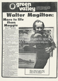
... Stony Creek Studio in Warrandyte and now married to contemporary installation artist Denise Keele-bedford. His first wife Alison, who died of breast cancer, was a weaver. Contents Newspaper article: "Walter Magilton: More to life than Maggie", Green Valley, section of Diamond Valley News, no date, details of Walter Magilton's career, his tame blackbird Maggie. Newspaper article: "Walter Magilton - Warrandyte", Network, October 1987, details of Walter Magilton's career, achievements and painting style. Newspaper article: "A modern twist on reality", Diamond Valley Leader, no date, Walter Magilton's exhibition at Bridges...Stony Creek Studio in Warrandyte and now married to contemporary installation artist Denise Keele-bedford. His first wife Alison, who died of breast cancer, was a weaver. Contents Newspaper article: "Walter Magilton: More to life than Maggie", Green Valley, section of Diamond Valley News, no date, details of Walter Magilton's career, his tame blackbird Maggie. Newspaper article: "Walter Magilton - Warrandyte", Network, October 1987, details of Walter Magilton's career, achievements and painting style. Newspaper article: "A modern twist on reality", Diamond Valley Leader, no date, Walter Magilton's exhibition at Bridges ...Walter Magilton left school early to become a dairy farmer in Western Victoria, returned to school and became a secondary school art teacher, eventually becoming an artist full-time, a painter, sculptor and jewellery maker. His paintings are in collections overseas and Australia. He teaches art from his Stony Creek Studio in Warrandyte and now married to contemporary installation artist Denise Keele-bedford. His first wife Alison, who died of breast cancer, was a weaver. Contents Newspaper article: "Walter Magilton: More to life than Maggie", Green Valley, section of Diamond Valley News, no date, details of Walter Magilton's career, his tame blackbird Maggie. Newspaper article: "Walter Magilton - Warrandyte", Network, October 1987, details of Walter Magilton's career, achievements and painting style. Newspaper article: "A modern twist on reality", Diamond Valley Leader, no date, Walter Magilton's exhibition at Bridges Restaurant, Hurstbridge. He collaborates with his wife Denise Keele-bedford, a contemporary installation artist. Newspaper article: "Walter Magilton: A Life's Journey in Art", Manningham and Nillumbik Bulletin, issue 51, July 2024. Walter Magilton to exhibit at Monsalvat. Newspaper article: "Alison Magilton: weaving the threads of her life". Manningham and Nillumbik Bulletin, May 2025. A tribute exhibition of the work of Alison Magilton. Newspaper article: "Last chance to see: Denise Keele-bedford and Walter Magilton at NaNY Gallery". Manningham and Nillumbik Bulletin, July 2025. Exhibition of works by Denise Keele-bedford and Walter Magilton.Newspaper clippings, A4 photocopies, etcwalter magilton, warrandyte victoria, stony creek studio warrandyte, denise keele-bedford, bridges restaurant hurstbridge, montsalvat, cowley's creek near camperdown, lou evans, carey grammar school, geelong teachers college, charles bush, lenton parr, william carey, mg car club, donvale christian college, warrandyte, bib silwell silverstone motors, alison margaret magilton nee byrne, jannie hodgson nee magilton, matthew magilton -
 Halls Gap & Grampians Historical Society
Map - Coloured
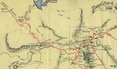
... Stony Creek and by the end of the 1890s a new track was built from "near the junction of Fyan's and Stony Creeks, up the gorge to the diggings settlement. The mining Department had paid L300 for its construction and, when completed, the track was "three miles and 30 chains in length, the side cuttings at the narrowest part being 10 feet between" and "the watercourses which cross the track at various points" having been "filled up with rocks rolled down the sides of the hills, and consequently there can be no damage caused by bushfires which destroyed the former wooden bridges erected on the old track to Wakeham's saw-mill, the remains of which are still to be seen at the side of the diggings" The article goes on to further describe the track as one which "can with ease travel with a two horse conveyance either up or down" and that the workmen engaged in the construction of the track would be attending "a ball that night at McKeon's farm near the mouth of the gap to celebrate the successful completion of the undertaking". 1900s At what time the bridle path was extended beyond Valley Gap to the Wartook basin on the Mt. ...Stony Creek and by the end of the 1890s a new track was built from "near the junction of Fyan's and Stony Creeks, up the gorge to the diggings settlement. The mining Department had paid L300 for its construction and, when completed, the track was "three miles and 30 chains in length, the side cuttings at the narrowest part being 10 feet between" and "the watercourses which cross the track at various points" having been "filled up with rocks rolled down the sides of the hills, and consequently there can be no damage caused by bushfires which destroyed the former wooden bridges erected on the old track to Wakeham's saw-mill, the remains of which are still to be seen at the side of the diggings" The article goes on to further describe the track as one which "can with ease travel with a two horse conveyance either up or down" and that the workmen engaged in the construction of the track would be attending "a ball that night at McKeon's farm near the mouth of the gap to celebrate the successful completion of the undertaking". 1900s At what time the bridle path was extended beyond Valley Gap to the Wartook basin on the Mt. ...Background on Bridle Path up Stony Creek Gorge Pre 1840 C. B. Hall, squatter on Mokepilly Run 1841-1842, first European to discover the Fyans Creek valley, the entrance of which became known as Hall's Gap. He later recorded that he followed a number of tracks which he assumed had been made by the Aboriginies and described one as "leading up a wild romantic glen and over on to the source of the Glenelg River". This could well have been the route taken up Stony Creek gorge by the first timber-cutters in this part of the Grampians to the saddle between the Wonderland and Mt. Difficult ranges known as Valley Gap 1850s/60s Timber cutters and shingle splitters were reported to be moving into the eastern side of the Grampians and by the mid 1860s there were a number of families connected to the supplying of timber to Pleasant Creek living in the "Hall's Gap ranges". John Wakeham, the first store owner in Pleasant Creek in 1854, established a timer-mill in upper Stony Creek Gorge in the late 1850s. Wakeham is credited for the clearing and levelling of the first bridle-path up the gorge. 1870s By the mid 1870s the track had been extended over Valley Gap to the Victoria Forest (the upper region of the Victoria Valley). McKeon's bullock team was known to have hauled red gum from the Valley to Stawell in the late 1870s and the 1880s. 1880s In 1887 an article in the Pleasant Creek news describes the Stony Creek Gorge track as "being a ledge alongside the mountain range, formed in the early days with the aid of earth and timber, along which the bullock teams used to travel to Horsham and plains of the Wimmera beyond." 1890s Gold was discovered in the catchment area of Stony Creek and by the end of the 1890s a new track was built from "near the junction of Fyan's and Stony Creeks, up the gorge to the diggings settlement. The mining Department had paid L300 for its construction and, when completed, the track was "three miles and 30 chains in length, the side cuttings at the narrowest part being 10 feet between" and "the watercourses which cross the track at various points" having been "filled up with rocks rolled down the sides of the hills, and consequently there can be no damage caused by bushfires which destroyed the former wooden bridges erected on the old track to Wakeham's saw-mill, the remains of which are still to be seen at the side of the diggings" The article goes on to further describe the track as one which "can with ease travel with a two horse conveyance either up or down" and that the workmen engaged in the construction of the track would be attending "a ball that night at McKeon's farm near the mouth of the gap to celebrate the successful completion of the undertaking". 1900s At what time the bridle path was extended beyond Valley Gap to the Wartook basin on the Mt. Difficult Range has not yet been determined. However, it is known that, by the turn of the century, people were travelling between Halls Gap and the caretakers' residence at Wartook Reservoir along what was now known as the "Bluff Road. Wartook's embankment had been constructed in 1887 and at that time there was already a track from Rosebrook Station homestead (near the present day Wartook Pottery) to the reservoir. Philip Rose owned both Rosebrook and Wartook Stations from the mid 1840s to the late 1850s and had regularly leased the Wartook basin to Cobb & Co. to rest horses there. 1920s Following the war of 1914-1918, tourism really took off in the Grampians, and Halls Gap rapidly grew. People would travel as far as they could on the many tracks then hike to the many lookouts being discovered by local tour guides. This led to the need for access across the range so that horse riders and the increasing number of vehicles could travel between Horsham and Halls Gap. To this end, the Bluff Road was improved and extended on 1929 and at its opening in March, 1930, by Lady Somers it was renamed the Mt. Victory Road.Map of Mt Victory Road and othersaccess routes, mt victory rd, bridle path, roads -
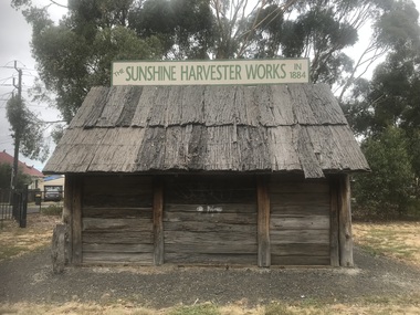 Sunshine and District Historical Society Incorporated
Photograph - Albion Photographs 2023, John Alchin, 2023
... McKay Smithy 2023 Photo 01.JPG 5571.02 - Barclay Reserve - Guide Hall 2023 Photo 01.JPG 5571.03 - Barclay Reserve - Scout Hall 2023 Photo 03.JPG 5571.04 - Derrimut St 30 - Good Shepherd Christian Church 2023 Photo 01.JPG 5571.05 - Forrest St Bridge 2023 Photo 01.JPG 5571.06 - Kororoit Creek - Stony Creek Outlet 2023 Photo 01.JPG 5571.07 - Kororoit Creek Swimming Pool 2023 Photo 01.JPG 5571.08 - Ridley St 11 2023 Photo 01.JPG 5571.09 - Ridley St 21 2023 Photo 01.JPG 5571.10 - Ridley St 40 2023 Photo 01.JPG 5571.11 - Sunshine City Bowling Club Green 2023 Photo 01.JPG 5571.12 - Talmage St 22 - Albion Mews Townhouses 2023 Photo 08.JPG 5571.13 - King Edward Av 53 2023 Photo 01.JPG 5571.14 - Ballarat Rd 556 Albion - Action Motor Industries 2023 Photo 02.JPG 5571.15 - Ballarat Rd 578 - 589 - Scrappy's Metal Recycling 2023 Photo 01.JPG 5571.16 - Ballarat Rd 578 - 589 - Scrappy's Metal Recycling 2023 Photo 03.JPG 5571.17 - Ballarat Rd 576 Albion 2023 Photo 02.JPG 5571.18 - Ballarat Rd 586 Albion - My Dream Cake.JPG 5571.19 - Ballarat Rd 621 - 625 Albion - Ferrous Forgings 2023.JPG 5571.20 - Carrington Dr 8 Albion - Khalid Bin Waleed Mosque 2023 Photo 01.JPG 5571.21 - Carrington Dr 19 Albion - Polish Club 2023.JPG 5571.22 - Carrington Dr 21 Albion - Hills And Mason 2023.JPG 5571.23 - Hulett St 3 Albion - Allen Foundry 2023 Photo 01.JPG 5571.24 - Hulett St Albion - St. ...Creek Swimming Pool Albion Mews Action Motor Industries Scrappy's Metal Recycling My Dream Cake Ferrous Forgings Khalid Bin Waleed Mosque Polish Club Hills And Mason Allen Foundry St. Johns Ambulance Darling Flour Mill 5571.01 - Barclay Reserve - H.V. McKay Smithy 2023 Photo 01.JPG 5571.02 - Barclay Reserve - Guide Hall 2023 Photo 01.JPG 5571.03 - Barclay Reserve - Scout Hall 2023 Photo 03.JPG 5571.04 - Derrimut St 30 - Good Shepherd Christian Church 2023 Photo 01.JPG 5571.05 - Forrest St Bridge 2023 Photo 01.JPG 5571.06 - Kororoit Creek - Stony Creek Outlet 2023 Photo 01.JPG 5571.07 - Kororoit Creek Swimming Pool 2023 Photo 01.JPG 5571.08 - Ridley St 11 2023 Photo 01.JPG 5571.09 - Ridley St 21 2023 Photo 01.JPG 5571.10 - Ridley St 40 2023 Photo 01.JPG 5571.11 - Sunshine City Bowling Club Green 2023 Photo 01.JPG 5571.12 - Talmage St 22 - Albion Mews Townhouses 2023 Photo 08.JPG 5571.13 - King Edward Av 53 2023 Photo 01.JPG 5571.14 - Ballarat Rd 556 Albion - Action Motor Industries 2023 Photo 02.JPG 5571.15 - Ballarat Rd 578 - 589 - Scrappy's Metal Recycling 2023 Photo 01.JPG 5571.16 - Ballarat Rd 578 - 589 - Scrappy's Metal Recycling 2023 Photo 03.JPG 5571.17 - Ballarat Rd 576 Albion 2023 Photo 02.JPG 5571.18 - Ballarat Rd 586 Albion - My Dream Cake.JPG 5571.19 - Ballarat Rd 621 - 625 Albion - Ferrous Forgings 2023.JPG 5571.20 - Carrington Dr 8 Albion - Khalid Bin Waleed Mosque 2023 Photo 01.JPG 5571.21 - Carrington Dr 19 Albion - Polish Club 2023.JPG 5571.22 - Carrington Dr 21 Albion - Hills And Mason 2023.JPG 5571.23 - Hulett St 3 Albion - Allen Foundry 2023 Photo 01.JPG 5571.24 - Hulett St Albion - St. ...These photographs provide a visual record of assorted buildings, street views, and notable locations throughout Albion in 2023.This photograph collection documents Albion in 2023.5571.01 - Barclay Reserve - H.V. McKay Smithy 2023 Photo 01.JPG 5571.02 - Barclay Reserve - Guide Hall 2023 Photo 01.JPG 5571.03 - Barclay Reserve - Scout Hall 2023 Photo 03.JPG 5571.04 - Derrimut St 30 - Good Shepherd Christian Church 2023 Photo 01.JPG 5571.05 - Forrest St Bridge 2023 Photo 01.JPG 5571.06 - Kororoit Creek - Stony Creek Outlet 2023 Photo 01.JPG 5571.07 - Kororoit Creek Swimming Pool 2023 Photo 01.JPG 5571.08 - Ridley St 11 2023 Photo 01.JPG 5571.09 - Ridley St 21 2023 Photo 01.JPG 5571.10 - Ridley St 40 2023 Photo 01.JPG 5571.11 - Sunshine City Bowling Club Green 2023 Photo 01.JPG 5571.12 - Talmage St 22 - Albion Mews Townhouses 2023 Photo 08.JPG 5571.13 - King Edward Av 53 2023 Photo 01.JPG 5571.14 - Ballarat Rd 556 Albion - Action Motor Industries 2023 Photo 02.JPG 5571.15 - Ballarat Rd 578 - 589 - Scrappy's Metal Recycling 2023 Photo 01.JPG 5571.16 - Ballarat Rd 578 - 589 - Scrappy's Metal Recycling 2023 Photo 03.JPG 5571.17 - Ballarat Rd 576 Albion 2023 Photo 02.JPG 5571.18 - Ballarat Rd 586 Albion - My Dream Cake.JPG 5571.19 - Ballarat Rd 621 - 625 Albion - Ferrous Forgings 2023.JPG 5571.20 - Carrington Dr 8 Albion - Khalid Bin Waleed Mosque 2023 Photo 01.JPG 5571.21 - Carrington Dr 19 Albion - Polish Club 2023.JPG 5571.22 - Carrington Dr 21 Albion - Hills And Mason 2023.JPG 5571.23 - Hulett St 3 Albion - Allen Foundry 2023 Photo 01.JPG 5571.24 - Hulett St Albion - St. Johns Ambulance 2023 Photo 01.JPG 5571.25 - Darling Flour Mill 2023 Photo 01.JPG 5571.26 - Darling Flour Mill 2023 Photo 02.JPG 5571.27 - Darling Flour Mill 2023 Photo 03.JPG 5571.28 - Darling Flour Mill 2023 Photo 04.JPG 5571.29 - Darling Flour Mill 2023 Photo 05.JPG 5571.30 - Anderson Rd 133 Albion 2023 Photo 01.JPG barclay reserve, forrest street, kororoit creek, ridley street, talmage street, king edward avenue, ballarat road, carrington drive, hulett street, sydney street, h.v. mckay smithy, girl guide hall, scout hall, kororoit creek swimming pool, albion mews, action motor industries, scrappy's metal recycling, my dream cake, ferrous forgings, khalid bin waleed mosque, polish club, hills and mason, allen foundry, st. johns ambulance, darling flour mill -
 Sunshine and District Historical Society Incorporated
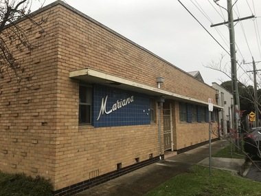
Photograph - Sunshine Photographs 2021 Part 4, John Alchin, 2021
... Bridge...Ritchie Court...Selwyn Park...Chus Hue Quang Temple...Royal Antediluvian Order of Buffaloes...Stony Creek...Pollard Reserve Railway Bridge Ritchie Court Selwyn Park Chus Hue Quang Temple Royal Antediluvian Order of Buffaloes Stony Creek Watt Street Sunshine Bus Exchange Sunshine Eldery Citizen's Club Sunshine Market Sunshine Municipal Offices Sunshine Ultimate Care Clinic 5618.01 - Monash St Sunshine - Mariana Hall 2021 Photo 01.JPG 5618.02 - Monash St Sunshine - Mariana Hall 2021 Photo 02.JPG 5618.03 - Parsons Reserve Sunshine 2021 Photo 01.JPG 5618.04 - Patterson Ave 14 - 16 Sunshine 2021 Photo 01.JPG 5618.05 - Pizzey St 12 Sunshine 2021 Photo 01.JPG 5618.06 - Pizzey St 12 Sunshine 2021 Photo 02.JPG 5618.07 - R.T. ...These photographs provide a visual record of assorted buildings, street views, and notable locations throughout Sunshine in 2021.This collection of photographs preserves a visual record of Sunshine 2021.5618.01 - Monash St Sunshine - Mariana Hall 2021 Photo 01.JPG 5618.02 - Monash St Sunshine - Mariana Hall 2021 Photo 02.JPG 5618.03 - Parsons Reserve Sunshine 2021 Photo 01.JPG 5618.04 - Patterson Ave 14 - 16 Sunshine 2021 Photo 01.JPG 5618.05 - Pizzey St 12 Sunshine 2021 Photo 01.JPG 5618.06 - Pizzey St 12 Sunshine 2021 Photo 02.JPG 5618.07 - R.T. Pollard Reserve Sunshine 2021 Photo 01.JPG 5618.08 - Railway Bridge Forrest St Sunshine 2021 Photo 08.JPG 5618.09 - Ritchie Crt 2A Sunshine 2021 Photo 01.JPG 5618.10 - Road Bridge Kororoit Creek Sunshine 2021 Photo 02.JPG 5618.11 - Second Ave 14 Sunshine 2021 Photo 01.JPG 5618.12 - Second Ave 14 Sunshine 2021 Photo 03.JPG 5618.13 - Selwyn Park 2021 Photo 02.JPG 5618.14 - Selwyn Park 2021 Photo 04.JPG 5618.15 - Selwyn Park 2021 Photo 06.JPG 5618.16 - Service St 10 - Chus Hue Quang Temple 2021 Photo 01.JPG 5618.17 - Station Place 42 Sunshine 2021 Photo 01.JPG 5618.18 - Station Place 48 Sunshine - Early 20th Century House 2021 Photo 01.JPG 5618.19 - Station Place Sunshine 56 - 66 2021 Photo 01.JPG 5618.20 - Station Place Sunshine 2021 Photo 01.JPG 5618.21 - Stony Creek Sunshine 2021 Photo 01.JPG 5618.22 - Sun Cres 2A - 8A Sunshine 2021 Photo 01.JPG 5618.23 - Sun Cres 11 - 13 Sunshine 2021 Photo 01.JPG 5618.24 - Sun Cres 12 Sunshine (Former State Bank) 2021 Photo 01.JPG 5618.25 - Sun Cres 25 - 27 Sunshine 2021 Photo 01.JPG 5618.26 - Sun Cres 27 Rear - Self Service Grocer 2021 Photo 01.JPG 5618.27 - Sun Cres 29 Rear - U.F.S. Dispensary 2021 Photo 01.JPG 5618.28 - Sun Cres 29A - Royal Antediluvian Order of Buffaloes (R.A.O.B.) 2021 Photo 01.JPG 5618.29 - Sun Cres 29A - Royal Antediluvian Order of Buffaloes (R.A.O.B.) 2021 Photo 02.JPG 5618.30 - Sun Cres 29A - Royal Antediluvian Order of Buffaloes (R.A.O.B.) 2021 Photo 05.JPG 5618.31 - Sun Cres 2021 Photo 01.JPG 5618.32 - Sun Crescent 31A Lane to 22-Watt St Sunshine 2021 Photo 01.JPG 5618.33 - Sun Cres 47 Sunshine - Former Miss Alma Pattinson Private Hospital 2021 Photo 01.JPG 5618.34 - Sunshine Corner of Durham Rd and City Place Sunshine 2021 Photo 01.JPG 5618.35 - Sunshine Bus Exchange Station Place Sunshine 2021 Photo 01.JPG 5618.36 - Sunshine Bus Interchange 2021 Photo 01.JPG 5618.37 - Sunshine Elderly Citizens Club Sign 2021 Photo 01.JPG 5618.38 - Sunshine Market City Place 2021 Photo 01.JPG 5618.39 - Sunshine Municipal Offices 2021 Photo 02.JPG 5618.40 - Sunshine Ultimate Care Clinic 127 Durham Rd Sunshine 2021 Photo 01.JPG 5618.41 - Station Place 40 And 42 Sunshine 2021 Photo 01.JPG sunshine, monash street, patterson avenue, pizzey street, forrest street, second avenue, service street, station place, sun crescent, city place, durham road, mariana hall, r.t. pollard reserve, railway bridge, ritchie court, selwyn park, chus hue quang temple, royal antediluvian order of buffaloes, stony creek, watt street, sunshine bus exchange, sunshine eldery citizen's club, sunshine market, sunshine municipal offices, sunshine ultimate care clinic -
 Sunshine and District Historical Society Incorporated
Photograph - Sunshine Photographs 2022 Part 1, John Alchin, 2022
... Stony Creek...Stony Creek Drain...Sun Crescent...City Place...Reflexio Qualis...Clarke Street...Derby Road Bridge...5627.01 - Alexandra Ave Sunshine - Sunshine Muncipal Offices 2022 Photo 01.JPG 5627.02 - Alexandra Ave Sunshine - Sunshine Muncipal Offices 2022 Photo 02.JPG 5627.03 - Alexandra Ave Sunshine - Sunshine Muncipal Offices 2022 Photo 05.JPG 5627.04 - Anderson Rd - Sunshine Vietnamese Baptist Church.JPG 5627.05 - Anderson Rd 79 - Andy's Service Station Sign 2022 Photo 02.JPG 5627.06 - Anderson Rd 79 Sunshine - Andy's Service Station Sign 2022 Photo 01.JPG 5627.07 - Anderson Rd 126 Sunshine - Sunhine Presbyterian Church Manse 2022 Photo 01.JPG 5627.08 - Andersons Rd 101 - 103 Sunshine 2022 Photo 01.JPG 5627.09 - Ballarat Rd 503 Sunshine - StoreLocal 2022 Photo 01.JPG 5627.10 - Ballarat Rd 505 Sunshine - Former AMF Ten Pin Bowling Centre 2022.JPG 5627.11 - Ballarat Rd 505 Sunshine - Melbourne Airport Rail Construction Support Facility Sign 2022 Photo 02.JPG 5627.12 - Ballarat Service Rd Sunshine - Stony Creek Culvert 2022 Photo 01.JPG 5627.13 - City Place 2 -4 Sunshine 2022 Photo 01.JPG 5627.14 - City Place 8 - 12 Sunshine 2022 Photo 01.JPG 5627.15 - City Place 22 Sunshine 2022 Photo 01.JPG 5627.16 - City Place 24 Sunshine 2022 Photo 01.JPG 5627.17 - City Place Sunshine - Reflexio Qualis 2022 Photo 02.JPG 5627.18 - Clarke St 6 Sunshine 2022 Photo 01.JPG 5627.19 - Derby Rd Sunshine - Kororoit Creek Bridge 2022 Photo 02.JPG 5627.20 - Derby St 105 Sunshine 2022 Photo 01.JPG 5627.21 - Devonshire Rd 5 Sunshine 2020 Photo 01.JPG 5627.22 - Dickson St 9 - 15 Sunshine 2022 Photo 01.JPG 5627.23 - Dickson St Sunshine - Reflexio Qualis 2022 Photo 02.JPG 5627.24 - Durham Rd 113 Sunshine 2022 Photo 01.JPG 5627.25 - Durham St 115 Sunshine - Former Bank 2022 Photo 01.JPG 5627.26 - Forrest St Railway Bridge Kororoit Creek 2022 Photo 01.JPG 5627.27 - Fraser St 75 Sunshine - Wilfred Clayton's House 2022 Photo 01.JPG 5627.28 - Fraser St Sunshine - Legenda's Garden 2022 Photo 01.JPG 5627.29 - Fraser St Sunshine - Legenda's Garden 2022 Photo 04.JPG 5627.30 - H.V. ...Sunshine Municipal Offices Alexandra Avenue Sunshine Sunshine Presbyterian Church Anderson Road Andy's Service Station Service Station Sunshine Presbyterian Church Manse Hot Springs Spa StoreLocal Ten Pin Bowling Centre Ballarat Road Service Road Stony Creek Stony Creek Drain Sun Crescent City Place Reflexio Qualis Clarke Street Derby Road Bridge Derby Road Devonshire Road Dickson Street Durham Road Glengala Road Bridge Fraser Street Legenda's Garden H.V. ...These photographs provide a visual record of assorted buildings, street views, and notable locations throughout Sunshine in 2022.This collection of photographs preserves a visual record of Sunshine 2022.5627.01 - Alexandra Ave Sunshine - Sunshine Muncipal Offices 2022 Photo 01.JPG 5627.02 - Alexandra Ave Sunshine - Sunshine Muncipal Offices 2022 Photo 02.JPG 5627.03 - Alexandra Ave Sunshine - Sunshine Muncipal Offices 2022 Photo 05.JPG 5627.04 - Anderson Rd - Sunshine Vietnamese Baptist Church.JPG 5627.05 - Anderson Rd 79 - Andy's Service Station Sign 2022 Photo 02.JPG 5627.06 - Anderson Rd 79 Sunshine - Andy's Service Station Sign 2022 Photo 01.JPG 5627.07 - Anderson Rd 126 Sunshine - Sunhine Presbyterian Church Manse 2022 Photo 01.JPG 5627.08 - Andersons Rd 101 - 103 Sunshine 2022 Photo 01.JPG 5627.09 - Ballarat Rd 503 Sunshine - StoreLocal 2022 Photo 01.JPG 5627.10 - Ballarat Rd 505 Sunshine - Former AMF Ten Pin Bowling Centre 2022.JPG 5627.11 - Ballarat Rd 505 Sunshine - Melbourne Airport Rail Construction Support Facility Sign 2022 Photo 02.JPG 5627.12 - Ballarat Service Rd Sunshine - Stony Creek Culvert 2022 Photo 01.JPG 5627.13 - City Place 2 -4 Sunshine 2022 Photo 01.JPG 5627.14 - City Place 8 - 12 Sunshine 2022 Photo 01.JPG 5627.15 - City Place 22 Sunshine 2022 Photo 01.JPG 5627.16 - City Place 24 Sunshine 2022 Photo 01.JPG 5627.17 - City Place Sunshine - Reflexio Qualis 2022 Photo 02.JPG 5627.18 - Clarke St 6 Sunshine 2022 Photo 01.JPG 5627.19 - Derby Rd Sunshine - Kororoit Creek Bridge 2022 Photo 02.JPG 5627.20 - Derby St 105 Sunshine 2022 Photo 01.JPG 5627.21 - Devonshire Rd 5 Sunshine 2020 Photo 01.JPG 5627.22 - Dickson St 9 - 15 Sunshine 2022 Photo 01.JPG 5627.23 - Dickson St Sunshine - Reflexio Qualis 2022 Photo 02.JPG 5627.24 - Durham Rd 113 Sunshine 2022 Photo 01.JPG 5627.25 - Durham St 115 Sunshine - Former Bank 2022 Photo 01.JPG 5627.26 - Forrest St Railway Bridge Kororoit Creek 2022 Photo 01.JPG 5627.27 - Fraser St 75 Sunshine - Wilfred Clayton's House 2022 Photo 01.JPG 5627.28 - Fraser St Sunshine - Legenda's Garden 2022 Photo 01.JPG 5627.29 - Fraser St Sunshine - Legenda's Garden 2022 Photo 04.JPG 5627.30 - H.V. McKay Memorial Gardens 2022 Photo 02.JPG 5627.31 - H.V. McKay Memorial Gardens 2022 Photo 03.JPG 5627.32 - H.V. McKay Memorial Gardens 2022 Photo 04.JPG 5627.33 - H.V. McKay Pedestrian Bridge 2022 Photo 01.JPG 5627.34 - Hampshire Rd 36 Sunshine 2022 Photo 01.JPG 5627.35 - Hampshire Rd 42 Sunshine 2022 Photo 01.JPG 5627.36 - Hampshire Rd 44 Sunshine 2022 Photo 01.JPG 5627.37 - Hampshire Rd 68 - 70 Sunshine 2022 Photo 01.JPG 5627.38 - Hampshire Rd 74 - 76 Sunshine - Shops 2022 Photo 01.JPG 5627.39 - Hampshire Rd 74 - 76 Sunshine 2022 Photo 01.JPG 5627.40 - Hampshire Rd 74 - 76 Sunshine 2022 Photo 02.JPG 5627.41 - Hampshire Rd 74 - 76 Sunshine 2022 Photo 04.JPG 5627.42 - Hampshire Rd 86 - 88 Sunshine - Shops 2022 Photo 02.JPG sunshine municipal offices, alexandra avenue, sunshine, sunshine presbyterian church, anderson road, andy's service station, service station, sunshine presbyterian church manse, hot springs spa, storelocal, ten pin bowling centre, ballarat road service road, stony creek, stony creek drain, sun crescent, city place, reflexio qualis, clarke street, derby road bridge, derby road, devonshire road, dickson street, durham road, glengala road bridge, fraser street, legenda's garden, h.v. mckay memorial gardens, sunshine pedestrian bridge, hampshire road -
 Sunshine and District Historical Society Incorporated
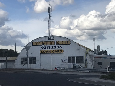
Photograph - Sunshine Photographs 2022 Part 2, John Alchin, 2022
... 5628.01 - Hampshire Rd 134 - Sunshine Panels 2022 Photo 01.JPG 5628.02 - Hampshire Rd 221A Sunshine - NNB Dessert House 2022 Photo 01.JPG 5628.03 - Hampshire Rd 234 - 246 Sunshine 2022 Photo 01.JPG 5628.04 - Hampshire Rd 254 2022 Sunshine Photo 01.JPG 5628.05 - Hampshire Rd 277 (Rear) Sunshine - Ruby's Club 2022 Photo 01.JPG 5628.06 - Hampshire Rd 324 - 328 Sunshine - Sunshine Plaza 2022 Photo 01.JPG 5628.07 - Hampshire Rd Sunshine Looking North from Railway Line 2022 Photo 01.JPG 5628.08 - Hampshire Rd Sunshine S-E Cnr Devonshire Rd 2022 Photo 01.JPG 5628.09 - Hampshire Rd Sunshine - Sunshine Primary School 2022 Photo 01.JPG 5628.10 - Sunshine Rifle Club Site Kororoit Creek Ford between the Shooting And Target Butts 2022 Photo 01.JPG 5628.11 - Sunshine Rifle Club Site Kororoit Creek Approx Site of Former Sunshine Rifle Range Target Butt Site 2022 Photo 01.JPG 5628.12 - Sunshine Rifle Club Site Kororoit Creek Approx Site of Former Sunshine Rifle Range Target Butt Site 2022 Photo 02.JPG 5628.13 - Kororoit Creek Fraser St Stony Creek Outlet 2022 Photo 01.JPG 5628.14 - Market Rd 6 Sunshine 2022 Photo 01.JPG 5628.15 - Market Rd 6 Sunshine 2022 Photo 02.JPG 5628.16 - Market Rd Sunshine 16 2022 Photo 01.JPG 5628.17 - McIntyre Rd Looking Toward Bendigo Railway Line Underpass 2022 Photo 01.JPG 5628.18 - McKay's Pedestrian Bridge 2022 Photo 01.JPG 5628.19 - Ormond Ave 31 Sunshine - United Pumps 2022 Photo 01.JPG 5628.20 - Second Ave 12 Sunshine 2022 Photo 02.JPG 5628.22 - Second Ave 23 - 25 Sunshine - Former Cabinet Works 2022 Photo 01.JPG 5628.21 - Man Lifting Cow Hampshire Rd 2020 Photo 01.JPG 5628.23 - Service St 5 Sunshine 2022 Photo 01.JPG 5628.24 - Service St 15 - 19 Sunshine - Building Under Construction 2022 Photo 01.JPG 5628.25 - St. ...Albans Road Sun Crescent Sunshine North 5628.01 - Hampshire Rd 134 - Sunshine Panels 2022 Photo 01.JPG 5628.02 - Hampshire Rd 221A Sunshine - NNB Dessert House 2022 Photo 01.JPG 5628.03 - Hampshire Rd 234 - 246 Sunshine 2022 Photo 01.JPG 5628.04 - Hampshire Rd 254 2022 Sunshine Photo 01.JPG 5628.05 - Hampshire Rd 277 (Rear) Sunshine - Ruby's Club 2022 Photo 01.JPG 5628.06 - Hampshire Rd 324 - 328 Sunshine - Sunshine Plaza 2022 Photo 01.JPG 5628.07 - Hampshire Rd Sunshine Looking North from Railway Line 2022 Photo 01.JPG 5628.08 - Hampshire Rd Sunshine S-E Cnr Devonshire Rd 2022 Photo 01.JPG 5628.09 - Hampshire Rd Sunshine - Sunshine Primary School 2022 Photo 01.JPG 5628.10 - Sunshine Rifle Club Site Kororoit Creek Ford between the Shooting And Target Butts 2022 Photo 01.JPG 5628.11 - Sunshine Rifle Club Site Kororoit Creek Approx Site of Former Sunshine Rifle Range Target Butt Site 2022 Photo 01.JPG 5628.12 - Sunshine Rifle Club Site Kororoit Creek Approx Site of Former Sunshine Rifle Range Target Butt Site 2022 Photo 02.JPG 5628.13 - Kororoit Creek Fraser St Stony Creek Outlet 2022 Photo 01.JPG 5628.14 - Market Rd 6 Sunshine 2022 Photo 01.JPG 5628.15 - Market Rd 6 Sunshine 2022 Photo 02.JPG 5628.16 - Market Rd Sunshine 16 2022 Photo 01.JPG 5628.17 - McIntyre Rd Looking Toward Bendigo Railway Line Underpass 2022 Photo 01.JPG 5628.18 - McKay's Pedestrian Bridge 2022 Photo 01.JPG 5628.19 - Ormond Ave 31 Sunshine - United Pumps 2022 Photo 01.JPG 5628.20 - Second Ave 12 Sunshine 2022 Photo 02.JPG 5628.22 - Second Ave 23 - 25 Sunshine - Former Cabinet Works 2022 Photo 01.JPG 5628.21 - Man Lifting Cow Hampshire Rd 2020 Photo 01.JPG 5628.23 - Service St 5 Sunshine 2022 Photo 01.JPG 5628.24 - Service St 15 - 19 Sunshine - Building Under Construction 2022 Photo 01.JPG 5628.25 - St. ...These photographs provide a visual record of assorted buildings, street views, and notable locations throughout Sunshine in 2022.This collection of photographs preserves a visual record of Sunshine 2022.5628.01 - Hampshire Rd 134 - Sunshine Panels 2022 Photo 01.JPG 5628.02 - Hampshire Rd 221A Sunshine - NNB Dessert House 2022 Photo 01.JPG 5628.03 - Hampshire Rd 234 - 246 Sunshine 2022 Photo 01.JPG 5628.04 - Hampshire Rd 254 2022 Sunshine Photo 01.JPG 5628.05 - Hampshire Rd 277 (Rear) Sunshine - Ruby's Club 2022 Photo 01.JPG 5628.06 - Hampshire Rd 324 - 328 Sunshine - Sunshine Plaza 2022 Photo 01.JPG 5628.07 - Hampshire Rd Sunshine Looking North from Railway Line 2022 Photo 01.JPG 5628.08 - Hampshire Rd Sunshine S-E Cnr Devonshire Rd 2022 Photo 01.JPG 5628.09 - Hampshire Rd Sunshine - Sunshine Primary School 2022 Photo 01.JPG 5628.10 - Sunshine Rifle Club Site Kororoit Creek Ford between the Shooting And Target Butts 2022 Photo 01.JPG 5628.11 - Sunshine Rifle Club Site Kororoit Creek Approx Site of Former Sunshine Rifle Range Target Butt Site 2022 Photo 01.JPG 5628.12 - Sunshine Rifle Club Site Kororoit Creek Approx Site of Former Sunshine Rifle Range Target Butt Site 2022 Photo 02.JPG 5628.13 - Kororoit Creek Fraser St Stony Creek Outlet 2022 Photo 01.JPG 5628.14 - Market Rd 6 Sunshine 2022 Photo 01.JPG 5628.15 - Market Rd 6 Sunshine 2022 Photo 02.JPG 5628.16 - Market Rd Sunshine 16 2022 Photo 01.JPG 5628.17 - McIntyre Rd Looking Toward Bendigo Railway Line Underpass 2022 Photo 01.JPG 5628.18 - McKay's Pedestrian Bridge 2022 Photo 01.JPG 5628.19 - Ormond Ave 31 Sunshine - United Pumps 2022 Photo 01.JPG 5628.20 - Second Ave 12 Sunshine 2022 Photo 02.JPG 5628.22 - Second Ave 23 - 25 Sunshine - Former Cabinet Works 2022 Photo 01.JPG 5628.21 - Man Lifting Cow Hampshire Rd 2020 Photo 01.JPG 5628.23 - Service St 5 Sunshine 2022 Photo 01.JPG 5628.24 - Service St 15 - 19 Sunshine - Building Under Construction 2022 Photo 01.JPG 5628.25 - St. Albans Rd Sunshine North - Former Albion Station Site (1859 - 1861) 2022 Photo 04.JPG 5628.26 - Station Place 66 Sunshine 2022 Photo 01.JPG 5628.27 - Sun Cres 5 - 7 Sunshine 2022 Photo 01.JPG 5628.28 - Sun Cres 5 - 9 Sunshine 2022 Photo 01.JPG 5628.29 - Sun Cres 9 Sunshine 2022 Photo 01.JPG 5628.30 - Sun Cres 11 - 17 Sunshine 2022 Photo 01.JPG 5628.31 - Sun Cres 15 - 21 Sunshine 2022 Photo 01.JPG 5628.32 - Sun Cres 29 Sunshine - Sun Cres Medical Centre 2022 Photo 01.JPG 5628.33 - Sun Cres 33 Sunshine 2022 Photo 01 (2).JPG 5628.34 - Sun Cres 33 Sunshine 2022 Photo 01.JPG 5628.35 - Sun Cres 202 Sunshine Photo 01.JPG 5628.36 - Sun Cres 2022 Sunshine Photo 02.JPG 5628.37 - Sun Cres 2022 Sunshine Photo 08.JPG 5628.38 - Sun Cres And Durham Rd Sunshine Intersection Looking South 2022 Photo 01.JPG 5628.39 - Sun Cres Sunshine 2022 Photo 03.JPG 5628.40 - Sun Cres Sunshine 2022 Photo 05.JPG 5628.41 - Sun Cres Sunshine 2022 Photo 06.JPG 5628.42 - Sun Cres Sunshine 2022 Photo 07.JPG 5628.43 - Sun Cres Sunshine 2022 Photo 09.JPG 5628.44 - Sun Cres Sunshine 2022 Photo 10.JPG 5628.45 - Sun Cres Sunshine Looking West 2022 Photo 01.JPG 5628.46 - Suns Cres Sunshine 31 2022 Photo 01.JPG 5628.47 - Suns Cres 32 - 36 Sunshine 2022 Photo 01.JPG hampshire road, sunshine, dickson street, sunshine plaza, sunshine primary school, kororoit creek, market road, mcintyre road, ormond avenue, second avenue, man lifting cow, service street, st. albans road, sun crescent, sunshine north -
 Sunshine and District Historical Society Incorporated
Photograph - Kororoit Creek in flood, Des Johnson, Copy March, 2013
... creek over Derby Road bridge between Adnerson Road and Mernda Street. High peak at 10:30am Daylight saying time people standing near end of Maye Street and Mernda Street 3 February 2005 by Des Johnson|Photocopy of photograph At Sunshine toward Ardeer concrete road bridge 7:45am Daylight light savig time looking down stream at the fast flowing stream brown colour waters under two concrete bridge supports Sunshine to Ballarat Railway line bridges 3 February 2005 by Des Johnson|Photocopy of photograph Near Stony Creek pipe outlet under Fraser Street into Kororoit Creek looking up stream of the big flood waters and the back fence of house at end of Mernda Street at 7:40am day light saving time 3 February 2005 by Des Johnson|Photocopy of photograph Between end of Fraser Street and Wridgeway Parade a rock crossing looking down stream along Kororoit Creek to end of Carter Street top middle of picture 3 February 2005 by Des Johnson...creek over Derby Road bridge between Adnerson Road and Mernda Street. High peak at 10:30am Daylight saying time people standing near end of Maye Street and Mernda Street 3 February 2005 by Des Johnson|Photocopy of photograph At Sunshine toward Ardeer concrete road bridge 7:45am Daylight light savig time looking down stream at the fast flowing stream brown colour waters under two concrete bridge supports Sunshine to Ballarat Railway line bridges 3 February 2005 by Des Johnson|Photocopy of photograph Near Stony Creek pipe outlet under Fraser Street into Kororoit Creek looking up stream of the big flood waters and the back fence of house at end of Mernda Street at 7:40am day light saving time 3 February 2005 by Des Johnson|Photocopy of photograph Between end of Fraser Street and Wridgeway Parade a rock crossing looking down stream along Kororoit Creek to end of Carter Street top middle of picture 3 February 2005 by Des Johnson Color photocopies Photograph Kororoit Creek in flood Des Johnson ...Kororoit Creek in floodPhotocopy of photograph Big flood waters flowing down Kororoit creek over Derby Road bridge between Adnerson Road and Mernda Street. High peak at 10:30am Daylight saying time people standing near end of Maye Street and Mernda Street 3 February 2005 by Des Johnson|Photocopy of photograph At Sunshine toward Ardeer concrete road bridge 7:45am Daylight light savig time looking down stream at the fast flowing stream brown colour waters under two concrete bridge supports Sunshine to Ballarat Railway line bridges 3 February 2005 by Des Johnson|Photocopy of photograph Near Stony Creek pipe outlet under Fraser Street into Kororoit Creek looking up stream of the big flood waters and the back fence of house at end of Mernda Street at 7:40am day light saving time 3 February 2005 by Des Johnson|Photocopy of photograph Between end of Fraser Street and Wridgeway Parade a rock crossing looking down stream along Kororoit Creek to end of Carter Street top middle of picture 3 February 2005 by Des Johnsonkororoit creek, sunshine, flood -
Lakes Entrance Historical Society
Book - Trestle Bridge Nowa Nowa, McGrath, Michelle, 2005
... Research, interpretation and management recommendations for the trestle bridge at Stony Creek, Nowa Nowa, Gippsland, Victoria...Lakes Entrance Historical Society 4 Marine Parade Lakes Entrance gippsland Transport Bridges Conservation and Land Management Culture Analysis Report Research, interpretation and management recommendations for the trestle bridge at Stony Creek, Nowa Nowa, Gippsland, Victoria Book Trestle Bridge Nowa Nowa McGrath, Michelle ...Research, interpretation and management recommendations for the trestle bridge at Stony Creek, Nowa Nowa, Gippsland, VictoriaConservation and Land Management Culture Analysis Reporttransport, bridges -
 Stawell Historical Society Inc
Photograph, Set of coloured print postcards of Stawell and Area
... . -2 Stony Creek Grampians Stawell - writing on back -3 Venus Bath Grampians Stawell -4 Town Hall Stawell -5 Central Park Stawell -6 Main Street Stawell -7 Glenorchy Bridge Stawell .... -2 Stony Creek Grampians Stawell - writing on back -3 Venus Bath Grampians Stawell -4 Town Hall Stawell -5 Central Park Stawell -6 Main Street Stawell -7 Glenorchy Bridge Stawell Tourism 7 coloured by hand postcards Set of coloured print postcards of Stawell and Area Photograph ...-1 Waterfall Grampians Stawell with writing on back. -2 Stony Creek Grampians Stawell - writing on back -3 Venus Bath Grampians Stawell -4 Town Hall Stawell -5 Central Park Stawell -6 Main Street Stawell -7 Glenorchy Bridge Stawell 7 coloured by hand postcardstourism