Showing 25 items matching "stony creek road"
-
 Eltham District Historical Society Inc
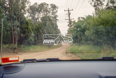
Slide - Photograph, Stony Creek Road, North Warrandyte, c.1993
... Stony Creek Road, North Warrandyte......Stony Creek Road...Eltham District Historical Society Inc 728 Main Rd Eltham melbourne infrastructure roads Doleen Road North Warrandyte Stony Creek Road 35mm colour positive transparency Mount - Black and White Stony Creek Road, North Warrandyte Slide Photograph ...35mm colour positive transparency Mount - Black and Whiteinfrastructure, roads, doleen road, north warrandyte, stony creek road -
 Eltham District Historical Society Inc
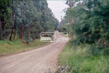
Slide - Photograph, Stony Creek Road, North Warrandyte, c.1993
... Stony Creek Road, North Warrandyte......Stony Creek Road...Eltham District Historical Society Inc 728 Main Rd Eltham melbourne infrastructure roads Doleen Road North Warrandyte Stony Creek Road 35mm colour positive transparency Mount - Black and White Stony Creek Road, North Warrandyte Slide Photograph ...35mm colour positive transparency Mount - Black and Whiteinfrastructure, roads, doleen road, north warrandyte, stony creek road -
 Eltham District Historical Society Inc
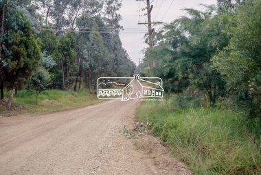
Slide - Photograph, Stony Creek Road, North Warrandyte, c.1993
... Stony Creek Road, North Warrandyte......stony creek road...Eltham District Historical Society Inc 728 Main Rd Eltham melbourne infrastructure roads doleen road north warrandyte stony creek road 35mm colour positive transparency Mount - Black and White Stony Creek Road, North Warrandyte Slide Photograph ...35mm colour positive transparency Mount - Black and Whiteinfrastructure, roads, doleen road, north warrandyte, stony creek road -
 Eltham District Historical Society Inc
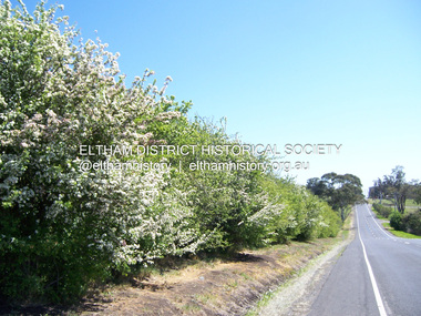
Photograph - Digital Photograph, Marguerite Marshall, Hawthorn hedges, Eltham-Yarra Glen Road, Kangaroo Ground, 3 October 2006
... roads were built in accordance with the magnetic bearings of their first survey in 1847 whether that suited the steep topography or not. This could force traffic to diverge when wet through Greensborough and Diamond Creek. Until 1921, the Eltham-Yarra Glen Road beside Wellers Restaurant, ‘dipped down into the upper reaches of Stony...roads were built in accordance with the magnetic bearings of their first survey in 1847 whether that suited the steep topography or not. This could force traffic to diverge when wet through Greensborough and Diamond Creek. Until 1921, the Eltham-Yarra Glen Road beside Wellers Restaurant, ‘dipped down into the upper reaches of Stony ...Hawthorn hedges are important reminders of Kangaroo Ground's Scottish heritage. They are Registered on the Victorian Heritage Register. They are "historically significant because the planting of hawthorn hedges reflects the adoption of Eurorpean farming techniques by the Kangaroo Ground population in the period following settlement and because the grid pattern of paddocks that the Hawthorn hedges define is very different to today's farm landscapes." Covered under Heritage Overlay, Nillumbik Planning Scheme. Published: Nillumbik Now and Then / Marguerite Marshall 2008; photographs Alan King with Marguerite Marshall.; p21 Hawthorn hedges bordering Kangaroo Ground’s gently rolling farmlands are important reminders of its Scottish heritage and are rare so close to Melbourne.1 As early as the 1840s newly arrived farmers from Scotland planted hawthorn hedges around their properties, to protect crops from the numerous kangaroos and wallabies. Many of these hedges survive today. These farmers had the good fortune to settle some of the most fertile land available for cropping in the Colony of Victoria. At that time the black volcanic soil could sustain an amazing two crops a year. By the mid 1850s, 500 acres (202ha) of wheat were growing in Kangaroo Ground. But the crops were threatened by kangaroos, which were so plentiful, that Surveyor-General, Robert Hoddle, named the district Kangaroo Ground in 1838. As post-and-rail fences proved inadequate barriers for the bounding kangaroos, the Scots planted hawthorn hedgerows as they had done in Scotland. Some also used the hedges to net birds, presumably for the table. Interestingly the farmers in the bordering townships of Panton Hill and Christmas Hills, did not plant hawthorn hedges around their properties. Perhaps it was because by the time they settled in the 1860s and 1870s most of the wildlife had been gunned down by residents.2 The canny Scots planted the hedges on public land outside their own farms, as the hedgerows could spread to about five yards (five m) in width. With this impenetrable barrier Kangaroo Ground’s industrious farmers flourished to gain the economic power that saw the Shire of Eltham governed from Kangaroo Ground for 79 years (1858-1937). The Scots jealously guarded their land, so hard to get in Scotland. That is why they refused to release any of it ‘for local roads to follow easier grades as was the case in surrounding districts where roads generally followed ridgelines or streams’.3 Instead the roads were built in accordance with the magnetic bearings of their first survey in 1847 whether that suited the steep topography or not. This could force traffic to diverge when wet through Greensborough and Diamond Creek. Until 1921, the Eltham-Yarra Glen Road beside Wellers Restaurant, ‘dipped down into the upper reaches of Stony Creek’.4 Later some corners were compulsorily cut for the increasing motor traffic. As late as the 1960s, corners were cut to form sweeping curves above and alongside the Kangaroo Ground Cemetery and opposite the Emergency Operations Centre. In the latter case, the farmers – understanding their hedgerows as important heritage – insisted upon their reinstatement to conform to the altered road alignment. Kangaroo Ground’s ancient manna gums also point to the district’s history and to that of the hedgerows. The Aboriginal people had transformed the original forests into grasslands with the fires they lit to attract kangaroos, (which the Scots were to exclude by planting hedgerows). But the Wurundjeri hunters left the gums (Eucalyptus vimminalis cygnetensis), on the grasslands as ‘stalking trees’ to hunt kangaroos. The hawthorn hedges in Kangaroo Ground were neglected for around 60 years from about the middle of the 20th century. Bushfires had created gaps and the hedgerows were not trimmed. Then in late 2005, local historian Mick Woiwod, formed a group to lobby the Nillumbik Shire to restore the hedges, which could last for many centuries. Some hedges in parts of Britain date back to AD 800.5 Although the original Scottish farmers have gone, the hedges are a reminder of when they flourished in the district, which has changed little in 150 years.This collection of almost 130 photos about places and people within the Shire of Nillumbik, an urban and rural municipality in Melbourne's north, contributes to an understanding of the history of the Shire. Published in 2008 immediately prior to the Black Saturday bushfires of February 7, 2009, it documents sites that were impacted, and in some cases destroyed by the fires. It includes photographs taken especially for the publication, creating a unique time capsule representing the Shire in the early 21st century. It remains the most recent comprehenesive publication devoted to the Shire's history connecting local residents to the past. nillumbik now and then (marshall-king) collection, eltham-yarra glen road, hawthorn hedgerow, kangaroo ground -
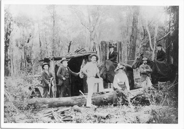 Halls Gap & Grampians Historical Society
Photograph - B/W, C 1887
... Halls Gap & Grampians Historical Society Centennial Hall 117-119 Grampians Road Halls Gap grampians Afred D'Alton was the first to discover alluvial good in Stony Creek PEOPLE D'Alton MINING Stoney Creek Larger photo taken from original Photo shows members of D/Alton family outside lean to at Stoney Creek diggings Left to Right Jim, John and Charles D/Alton, Henrietta and Amy (John's daughters) Galbraith (John's son) Clare (Charlie and Jim's sister) Photograph B/W ...Afred D'Alton was the first to discover alluvial good in Stony CreekPhoto shows members of D/Alton family outside lean to at Stoney Creek diggings Left to Right Jim, John and Charles D/Alton, Henrietta and Amy (John's daughters) Galbraith (John's son) Clare (Charlie and Jim's sister)Larger photo taken from original people, d'alton, mining, stoney creek -
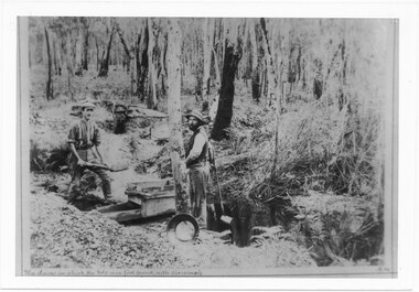 Halls Gap & Grampians Historical Society
Photograph - B/W, C 1887
... Halls Gap & Grampians Historical Society Centennial Hall 117-119 Grampians Road Halls Gap grampians D'Alton's searching for alluvial gold. Photo shows Alfred and Charles D'Alton at Stony Creek Diggings. ...D'Alton's searching for alluvial gold. Photo shows Alfred and Charles D'Alton at Stony Creek Diggings. Charles is on the right and Alfred is on the left. Records 126 and 127 are enlargements from this photo showing each man separately.Photo shows two men working near a sluice. One man is shovelling into a sluice, on a creek and the other is holding an implement. A gold pan rests against a tree.people, d'alton, mining, stoney creek -
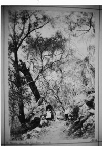 Halls Gap & Grampians Historical Society
Photograph - Sepia, C 1898
... Road Halls Gap grampians Woman known as Maggie Galbraith. First names of the three Galbraith children not known. Track called the Jinker track. For further information on Jinker Tracks, refer to pp. 101-102 of Victoria's Wonderland. ACCESS ROUTES Vehicle track PEOPLE Galbraith 'A turn in the Jinker track Maggie Galbraith with her small charges on Stony Creek ...Woman known as Maggie Galbraith. First names of the three Galbraith children not known. Track called the Jinker track. For further information on Jinker Tracks, refer to pp. 101-102 of Victoria's Wonderland.Photo show 1 woman, 3 girls and 2 boys on a track in the bush'A turn in the Jinker track Maggie Galbraith with her small charges on Stony Creek gorge bridle trackaccess routes, vehicle track, people, galbraith -
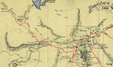 Halls Gap & Grampians Historical Society
Map - Coloured
... Halls Gap & Grampians Historical Society Centennial Hall 117-119 Grampians Road Halls Gap grampians Background on Bridle Path up Stony Creek Gorge Pre 1840 C. ...Background on Bridle Path up Stony Creek Gorge Pre 1840 C. B. Hall, squatter on Mokepilly Run 1841-1842, first European to discover the Fyans Creek valley, the entrance of which became known as Hall's Gap. He later recorded that he followed a number of tracks which he assumed had been made by the Aboriginies and described one as "leading up a wild romantic glen and over on to the source of the Glenelg River". This could well have been the route taken up Stony Creek gorge by the first timber-cutters in this part of the Grampians to the saddle between the Wonderland and Mt. Difficult ranges known as Valley Gap 1850s/60s Timber cutters and shingle splitters were reported to be moving into the eastern side of the Grampians and by the mid 1860s there were a number of families connected to the supplying of timber to Pleasant Creek living in the "Hall's Gap ranges". John Wakeham, the first store owner in Pleasant Creek in 1854, established a timer-mill in upper Stony Creek Gorge in the late 1850s. Wakeham is credited for the clearing and levelling of the first bridle-path up the gorge. 1870s By the mid 1870s the track had been extended over Valley Gap to the Victoria Forest (the upper region of the Victoria Valley). McKeon's bullock team was known to have hauled red gum from the Valley to Stawell in the late 1870s and the 1880s. 1880s In 1887 an article in the Pleasant Creek news describes the Stony Creek Gorge track as "being a ledge alongside the mountain range, formed in the early days with the aid of earth and timber, along which the bullock teams used to travel to Horsham and plains of the Wimmera beyond." 1890s Gold was discovered in the catchment area of Stony Creek and by the end of the 1890s a new track was built from "near the junction of Fyan's and Stony Creeks, up the gorge to the diggings settlement. The mining Department had paid L300 for its construction and, when completed, the track was "three miles and 30 chains in length, the side cuttings at the narrowest part being 10 feet between" and "the watercourses which cross the track at various points" having been "filled up with rocks rolled down the sides of the hills, and consequently there can be no damage caused by bushfires which destroyed the former wooden bridges erected on the old track to Wakeham's saw-mill, the remains of which are still to be seen at the side of the diggings" The article goes on to further describe the track as one which "can with ease travel with a two horse conveyance either up or down" and that the workmen engaged in the construction of the track would be attending "a ball that night at McKeon's farm near the mouth of the gap to celebrate the successful completion of the undertaking". 1900s At what time the bridle path was extended beyond Valley Gap to the Wartook basin on the Mt. Difficult Range has not yet been determined. However, it is known that, by the turn of the century, people were travelling between Halls Gap and the caretakers' residence at Wartook Reservoir along what was now known as the "Bluff Road. Wartook's embankment had been constructed in 1887 and at that time there was already a track from Rosebrook Station homestead (near the present day Wartook Pottery) to the reservoir. Philip Rose owned both Rosebrook and Wartook Stations from the mid 1840s to the late 1850s and had regularly leased the Wartook basin to Cobb & Co. to rest horses there. 1920s Following the war of 1914-1918, tourism really took off in the Grampians, and Halls Gap rapidly grew. People would travel as far as they could on the many tracks then hike to the many lookouts being discovered by local tour guides. This led to the need for access across the range so that horse riders and the increasing number of vehicles could travel between Horsham and Halls Gap. To this end, the Bluff Road was improved and extended on 1929 and at its opening in March, 1930, by Lady Somers it was renamed the Mt. Victory Road.Map of Mt Victory Road and othersaccess routes, mt victory rd, bridle path, roads -
 Halls Gap & Grampians Historical Society
Photograph - B/W, C 1931
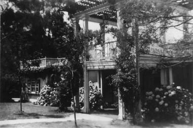
... Road Halls Gap grampians A major rebuilding project took place. Brothers John & Thomas Morgan with local storekeeper Harold Goodwin Taylor designing and building a grand new Guest House with 22 bedrooms plus the original bungalows. Unheard of at the time the guests bedrooms had hand basins with hot & cold running water. This was achieved by building a weir on Stony Creek ...A major rebuilding project took place. Brothers John & Thomas Morgan with local storekeeper Harold Goodwin Taylor designing and building a grand new Guest House with 22 bedrooms plus the original bungalows. Unheard of at the time the guests bedrooms had hand basins with hot & cold running water. This was achieved by building a weir on Stony Creek and piping the water to a high holding tank at the guest house. The dining room was a grand affair, a 4.5 metre high ceiling with beautiful gold leaf cornices, art deco ceiling and wall lights with feature plaster lights in the form of blue bells, wall to wall carpet and Kentia palms completed the picture. Ladies & gentlemen dressed for dinner, the ladies resplendent in their long evening gowns and jewellery would come down the stairway from the entrance hall to the lounge then the dining room. The tables were beautifully appointed with damask table cloths & fine silverware. The kitchen was well appointed with a huge coal fired range and a donkey for hot water. Milk & cream, bacon & pork, chicken & eggs together with vegetables were all home grown on the property. A large ballroom with a beautiful timber floor was the scene after dinner for many dances and party nights with guests from other establishments and locals joining in for the night. A huge fernery was also a feature of the gardens. During the day tennis parties would be held on the courts, together with horse riding and guided walks were taken out by local guide Gilbert Rogers.Photo of newly built Grampian Houseaccommodation, guesthouses, accommodation, grampian house -
 Halls Gap & Grampians Historical Society
Photograph - B/W
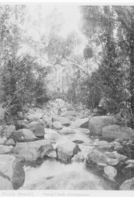
... Halls Gap & Grampians Historical Society Centennial Hall 117-119 Grampians Road Halls Gap grampians The creek is Stoney Creek SCENERY Stoney Creek Picard Stawell Stony Creek (sic) Grampians Photo shows man sitting on rock in middle of creek Photograph B/W ...The creek is Stoney CreekPhoto shows man sitting on rock in middle of creekPicard Stawell Stony Creek (sic) Grampians scenery, stoney creek -
 Halls Gap & Grampians Historical Society
Newspaper - Photocopy
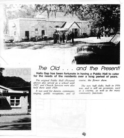
... Road Halls Gap grampians The article shows a photo of the original Hall's Gap Hall and the (then) new Hall, which was built in 1956. The copy has been scanned as two separate images (because it was too large for the scanner). the second image is stored under "Additional Images". HISTORY OF HALL'S GAP HALL: No village, no matter how small, could possibly survive without a public meeting place, and Hall's Gap was no exception, even in 1899-1900. Actually it was the locals of Stony Creek ...The article shows a photo of the original Hall's Gap Hall and the (then) new Hall, which was built in 1956. The copy has been scanned as two separate images (because it was too large for the scanner). the second image is stored under "Additional Images". HISTORY OF HALL'S GAP HALL: No village, no matter how small, could possibly survive without a public meeting place, and Hall's Gap was no exception, even in 1899-1900. Actually it was the locals of Stony Creek village, as Hall's Gap was known for a short time, who decided to hold a meeting to find out how much interest there was in building a town hall! They soon found out that support was overwhelming, as can be seen by the fact that 14 gentlemen nominated for a position on the committee of four! Several motions were moved at that meeting, mainly with reference to the materials to be used, for instance that no "wattle and daub", but rather slabs of bark and local bush logs be used. The walls were to be constructed of slabs, 6 feet long, 9 inches wide and two inches thick. Uprights were to be 9 feet high and at least 9 inches thick. Sheets of bark, all 32 of them, had to be 8 feet by 8 feet. Tenders for the building materials were called on 9 March 1899 and, 21 days later, McKeon Brothers won the right to supply all the material for the princely sum of 4 pounds 10 shillings. The size of the hall was to be 20 feet by 10 feet. The first hall served the community well for the next thirteen years, being regularly used as a place of entertainment and religious worship. The growing community soon realised the need for a larger venue, with better facilities, so once again the townsfolk rallied to raise funds for a new hall, realising their dream around 1913. In 1921 a schoolteacher was provided by the education department but as there was no school building she was expected to use the hall. Mainly lessons were held in the kitchen as it was much warmer than the hall itself, and it was not unusual for up to twenty children to be taught, ranging in age from 5 to 14 years. It was not until 1928 that an official school was built. 1955-56 were years of great excitement. The Progress Association was in charge of deciding the format for the new hall, and there were many rowdy meetings beforehand. Some members had much more vision than others, and to some the amount of money required seemed astronomical. Two hall committee members resigned over differences of opinion but amazingly it all came together in the end, albeit at a greater cost than had been anticipated. There is only one record of a grant being made for the building,1500 pounds, and it came for the Minister of Public Works. Estimated cost of the building was around 8,000 pounds, and when finally finished it was just slightly over, but bank charges and interest took it to well over 9,000 pounds. An electric light generator was included and lighting installed. The SEC electricity was connected in 1962.A copy of a newspaper article entitled 'The Old . . . and the Present!', which includes two photographs.buildings, halls -
 Lorne Historical Society
Photograph, Stony Creek Construction Campsite Great Ocean Road
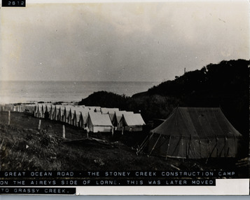
... Stony Creek Construction Campsite Great Ocean Road...Lorne Historical Society Lorne Community House Mountjoy Parade Lorne great-ocean-road G.O.R; Construction camp site; tents; C.R.B.; Grassy Creek; Photograph showing overview of Stony Creek construction campsite on the Airey's Inlet side of Lorne. ...Photograph showing overview of Stony Creek construction campsite on the Airey's Inlet side of Lorne. This site later moved to Grassy Creek.g.o.r; construction camp site; tents; c.r.b.; grassy creek; -
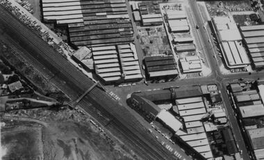
 Sunshine and District Historical Society Incorporated
Photograph - Sunshine Photographs 2021 Part 1, John Alchin, 2021
... Road...Arthur Beachley Reserve...KFC...Black Arch...Stony Creek...Sunshine Anderson Road Ardoyne Street Ballarat Road City Place Clarke Street Corio Street Couch Street Derby Road Devonshire Road Arthur Beachley Reserve KFC Black Arch Stony Creek Hope of Life Community Church Devonshire House Salvation Army Hall The Clinic 5615.01 - Anderson Rd 53A Sunshine 2021 Photo 01.JPG 5615.02 - Ardoyne St 11 Sunshine 2021 Photo 02.JPG 5615.03 - Arthur Beachley Reserve Pavilion Arthur Beachley Reserve 2021 Photo 02.JPG 5615.04 - Arthur Beachley Reserve Pavilion Arthur Beachley Reserve 2021 Photo 03.JPG 5615.05 - Arthur Beachley Reserve Pavilion Arthur Beachley Reserve 2021 Photo 09.JPG 5615.06 - Arthur Beachley Reserve Pavilion Arthur Beachley Reserve 2021 Photo 11.JPG 5615.07 - Ballarat Rd 429A Sunshine - KFC 2021 Photo 01.JPG 5615.08 - Ballarat Rd 437A Sunshine - Service Station 2021 Photo 01.JPG 5615.09 - Ballarat Rd 447 Sunshine - Repco 2021 Photo 01.JPG 5615.10 - Ballarat Rd 459 Sunshine 2021 Former Reception Centre Photo 02.JPG 5615.11 - Ballarat Rd 463 - 465 Sunshine 2021 Photo 01.JPG 5615.12 - Ballarat Rd 463 Sunshine 2021 Photo 01.JPG 5615.13 - Ballarat Rd 479 - 481 Sunshine 2021 Photo 01.JPG 5615.14 - Benjamin St 90 Sunshine 2021 Photo 01.JPG 5615.15 - Benjamin St 90 Sunshine 2021 Photo 03.JPG 5615.16 - Benjamin St 90 Sunshine 2021 Photo 04.JPG 5615.17 - Black Arch Stony Creek Sunshine 2021 Photo 02.JPG 5615.18 - Black Arch Stony Creek Sunshine 2021 Photo 03.JPG 5615.19 - City Place 2 - 4 Sunshine 2021 Photo 01.JPG 5615.20 - City Place 10 - 28 Rear 2021 Photo 01.JPG 5615.21 - City Place 17 Sunshine (Old Music Shop Entrance) 2021 Photo 01.JPG 5615.22 - City Place 28 - 30 Sunshine 2021 Photo 01.JPG 5615.23 - City Place Sunshine Looking South West 2021 Photo 01.JPG 5615.24 - City Place Sunshine South East Side 2021 Photo 01.JPG 5615.25 - Clarke St 5 - 9 Sunshine 2021 Photo 01.JPG 5615.26 - Clarke St 6 - 8 Sunshine 2021 Photo 01.JPG 5615.27 - Clarke St No 1 Sunshine 2021 Photo 02.JPG 5615.28 - Clarke St Sunshine Looking South From Devonshire Rd 2021 Photo 01.JPG 5615.29 - Corio St 3 Sunshine 2021 Photo 01.JPG 5615.30 - Corio St Sunshine - Hope of Life Community Church (Former Lions Senior Citizens Centre) 2021 Photo 02.JPG 5615.31 - Couch St 35 Sunshine - Restore A Sash (Former Service Station) 2021 Photo 01.JPG 5615.32 - Derby Rd 6A Sunshine - Clay Works Display House (Former Sunshine Potteries Site ) 2021 Photo 01.JPG 5615.33 - Derby Rd 6A Sunshine - Clay Works Display House (Former Sunshine Potteries Site ) 2021 Photo 02.JPG 5615.34 - Derby Rd 112 Sunshine 2021 Photo 01.JPG 5615.35 - Devonshire House Devonshire Rd Sunshine 2021 Photo 01.JPG 5615.36 - Devonshire Rd 22 Sunshine - Devonshire Pharmacy 2021 Photo 01.JPG 5615.37 - Devonshire Rd 26 - 28 - Olarenshaw's Paint Shop Sunshine 2021 Photo 01.JPG 5615.38 - Devonshire Rd 42 - Salvation Army Hall 2021 Photo 02.JPG 5615.39 - Devonshire Rd 42 - Salvation Army Hall 2021 Photo 01.JPG 5615.40 - Devonshire Rd 53 - The Clinic 2021 Photo 01.JPG Large collection of digital photographs that have be split over five identification numbers. ...These photographs provide a visual record of assorted buildings, street views, and notable locations throughout Sunshine in 2021.This collection of photographs preserves a visual record of Sunshine 2021.5615.01 - Anderson Rd 53A Sunshine 2021 Photo 01.JPG 5615.02 - Ardoyne St 11 Sunshine 2021 Photo 02.JPG 5615.03 - Arthur Beachley Reserve Pavilion Arthur Beachley Reserve 2021 Photo 02.JPG 5615.04 - Arthur Beachley Reserve Pavilion Arthur Beachley Reserve 2021 Photo 03.JPG 5615.05 - Arthur Beachley Reserve Pavilion Arthur Beachley Reserve 2021 Photo 09.JPG 5615.06 - Arthur Beachley Reserve Pavilion Arthur Beachley Reserve 2021 Photo 11.JPG 5615.07 - Ballarat Rd 429A Sunshine - KFC 2021 Photo 01.JPG 5615.08 - Ballarat Rd 437A Sunshine - Service Station 2021 Photo 01.JPG 5615.09 - Ballarat Rd 447 Sunshine - Repco 2021 Photo 01.JPG 5615.10 - Ballarat Rd 459 Sunshine 2021 Former Reception Centre Photo 02.JPG 5615.11 - Ballarat Rd 463 - 465 Sunshine 2021 Photo 01.JPG 5615.12 - Ballarat Rd 463 Sunshine 2021 Photo 01.JPG 5615.13 - Ballarat Rd 479 - 481 Sunshine 2021 Photo 01.JPG 5615.14 - Benjamin St 90 Sunshine 2021 Photo 01.JPG 5615.15 - Benjamin St 90 Sunshine 2021 Photo 03.JPG 5615.16 - Benjamin St 90 Sunshine 2021 Photo 04.JPG 5615.17 - Black Arch Stony Creek Sunshine 2021 Photo 02.JPG 5615.18 - Black Arch Stony Creek Sunshine 2021 Photo 03.JPG 5615.19 - City Place 2 - 4 Sunshine 2021 Photo 01.JPG 5615.20 - City Place 10 - 28 Rear 2021 Photo 01.JPG 5615.21 - City Place 17 Sunshine (Old Music Shop Entrance) 2021 Photo 01.JPG 5615.22 - City Place 28 - 30 Sunshine 2021 Photo 01.JPG 5615.23 - City Place Sunshine Looking South West 2021 Photo 01.JPG 5615.24 - City Place Sunshine South East Side 2021 Photo 01.JPG 5615.25 - Clarke St 5 - 9 Sunshine 2021 Photo 01.JPG 5615.26 - Clarke St 6 - 8 Sunshine 2021 Photo 01.JPG 5615.27 - Clarke St No 1 Sunshine 2021 Photo 02.JPG 5615.28 - Clarke St Sunshine Looking South From Devonshire Rd 2021 Photo 01.JPG 5615.29 - Corio St 3 Sunshine 2021 Photo 01.JPG 5615.30 - Corio St Sunshine - Hope of Life Community Church (Former Lions Senior Citizens Centre) 2021 Photo 02.JPG 5615.31 - Couch St 35 Sunshine - Restore A Sash (Former Service Station) 2021 Photo 01.JPG 5615.32 - Derby Rd 6A Sunshine - Clay Works Display House (Former Sunshine Potteries Site ) 2021 Photo 01.JPG 5615.33 - Derby Rd 6A Sunshine - Clay Works Display House (Former Sunshine Potteries Site ) 2021 Photo 02.JPG 5615.34 - Derby Rd 112 Sunshine 2021 Photo 01.JPG 5615.35 - Devonshire House Devonshire Rd Sunshine 2021 Photo 01.JPG 5615.36 - Devonshire Rd 22 Sunshine - Devonshire Pharmacy 2021 Photo 01.JPG 5615.37 - Devonshire Rd 26 - 28 - Olarenshaw's Paint Shop Sunshine 2021 Photo 01.JPG 5615.38 - Devonshire Rd 42 - Salvation Army Hall 2021 Photo 02.JPG 5615.39 - Devonshire Rd 42 - Salvation Army Hall 2021 Photo 01.JPG 5615.40 - Devonshire Rd 53 - The Clinic 2021 Photo 01.JPG sunshine, anderson road, ardoyne street, ballarat road, city place, clarke street, corio street, couch street, derby road, devonshire road, arthur beachley reserve, kfc, black arch, stony creek, hope of life community church, devonshire house, salvation army hall, the clinic -
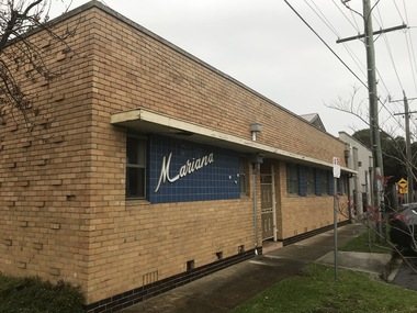 Sunshine and District Historical Society Incorporated
Photograph - Sunshine Photographs 2021 Part 4, John Alchin, 2021
... Road...Mariana Hall...R.T. Pollard Reserve...Railway Bridge...Ritchie Court...Selwyn Park...Chus Hue Quang Temple...Royal Antediluvian Order of Buffaloes...Stony Creek...Road Mariana Hall R.T. Pollard Reserve Railway Bridge Ritchie Court Selwyn Park Chus Hue Quang Temple Royal Antediluvian Order of Buffaloes Stony Creek Watt Street Sunshine Bus Exchange Sunshine Eldery Citizen's Club Sunshine Market Sunshine Municipal Offices Sunshine Ultimate Care Clinic 5618.01 - Monash St Sunshine - Mariana Hall 2021 Photo 01.JPG 5618.02 - Monash St Sunshine - Mariana Hall 2021 Photo 02.JPG 5618.03 - Parsons Reserve Sunshine 2021 Photo 01.JPG 5618.04 - Patterson Ave 14 - 16 Sunshine 2021 Photo 01.JPG 5618.05 - Pizzey St 12 Sunshine 2021 Photo 01.JPG 5618.06 - Pizzey St 12 Sunshine 2021 Photo 02.JPG 5618.07 - R.T. ...These photographs provide a visual record of assorted buildings, street views, and notable locations throughout Sunshine in 2021.This collection of photographs preserves a visual record of Sunshine 2021.5618.01 - Monash St Sunshine - Mariana Hall 2021 Photo 01.JPG 5618.02 - Monash St Sunshine - Mariana Hall 2021 Photo 02.JPG 5618.03 - Parsons Reserve Sunshine 2021 Photo 01.JPG 5618.04 - Patterson Ave 14 - 16 Sunshine 2021 Photo 01.JPG 5618.05 - Pizzey St 12 Sunshine 2021 Photo 01.JPG 5618.06 - Pizzey St 12 Sunshine 2021 Photo 02.JPG 5618.07 - R.T. Pollard Reserve Sunshine 2021 Photo 01.JPG 5618.08 - Railway Bridge Forrest St Sunshine 2021 Photo 08.JPG 5618.09 - Ritchie Crt 2A Sunshine 2021 Photo 01.JPG 5618.10 - Road Bridge Kororoit Creek Sunshine 2021 Photo 02.JPG 5618.11 - Second Ave 14 Sunshine 2021 Photo 01.JPG 5618.12 - Second Ave 14 Sunshine 2021 Photo 03.JPG 5618.13 - Selwyn Park 2021 Photo 02.JPG 5618.14 - Selwyn Park 2021 Photo 04.JPG 5618.15 - Selwyn Park 2021 Photo 06.JPG 5618.16 - Service St 10 - Chus Hue Quang Temple 2021 Photo 01.JPG 5618.17 - Station Place 42 Sunshine 2021 Photo 01.JPG 5618.18 - Station Place 48 Sunshine - Early 20th Century House 2021 Photo 01.JPG 5618.19 - Station Place Sunshine 56 - 66 2021 Photo 01.JPG 5618.20 - Station Place Sunshine 2021 Photo 01.JPG 5618.21 - Stony Creek Sunshine 2021 Photo 01.JPG 5618.22 - Sun Cres 2A - 8A Sunshine 2021 Photo 01.JPG 5618.23 - Sun Cres 11 - 13 Sunshine 2021 Photo 01.JPG 5618.24 - Sun Cres 12 Sunshine (Former State Bank) 2021 Photo 01.JPG 5618.25 - Sun Cres 25 - 27 Sunshine 2021 Photo 01.JPG 5618.26 - Sun Cres 27 Rear - Self Service Grocer 2021 Photo 01.JPG 5618.27 - Sun Cres 29 Rear - U.F.S. Dispensary 2021 Photo 01.JPG 5618.28 - Sun Cres 29A - Royal Antediluvian Order of Buffaloes (R.A.O.B.) 2021 Photo 01.JPG 5618.29 - Sun Cres 29A - Royal Antediluvian Order of Buffaloes (R.A.O.B.) 2021 Photo 02.JPG 5618.30 - Sun Cres 29A - Royal Antediluvian Order of Buffaloes (R.A.O.B.) 2021 Photo 05.JPG 5618.31 - Sun Cres 2021 Photo 01.JPG 5618.32 - Sun Crescent 31A Lane to 22-Watt St Sunshine 2021 Photo 01.JPG 5618.33 - Sun Cres 47 Sunshine - Former Miss Alma Pattinson Private Hospital 2021 Photo 01.JPG 5618.34 - Sunshine Corner of Durham Rd and City Place Sunshine 2021 Photo 01.JPG 5618.35 - Sunshine Bus Exchange Station Place Sunshine 2021 Photo 01.JPG 5618.36 - Sunshine Bus Interchange 2021 Photo 01.JPG 5618.37 - Sunshine Elderly Citizens Club Sign 2021 Photo 01.JPG 5618.38 - Sunshine Market City Place 2021 Photo 01.JPG 5618.39 - Sunshine Municipal Offices 2021 Photo 02.JPG 5618.40 - Sunshine Ultimate Care Clinic 127 Durham Rd Sunshine 2021 Photo 01.JPG 5618.41 - Station Place 40 And 42 Sunshine 2021 Photo 01.JPG sunshine, monash street, patterson avenue, pizzey street, forrest street, second avenue, service street, station place, sun crescent, city place, durham road, mariana hall, r.t. pollard reserve, railway bridge, ritchie court, selwyn park, chus hue quang temple, royal antediluvian order of buffaloes, stony creek, watt street, sunshine bus exchange, sunshine eldery citizen's club, sunshine market, sunshine municipal offices, sunshine ultimate care clinic -
 Sunshine and District Historical Society Incorporated
Photograph - Sunshine Photographs 2022 Part 1, John Alchin, 2022
... Road...Stony Creek...Sunshine Municipal Offices Alexandra Avenue Sunshine Sunshine Presbyterian Church Anderson Road Andy's Service Station Service Station Sunshine Presbyterian Church Manse Hot Springs Spa StoreLocal Ten Pin Bowling Centre Ballarat Road Service Road Stony Creek Stony Creek Drain Sun Crescent City Place Reflexio Qualis Clarke Street Derby Road Bridge Derby Road Devonshire Road Dickson Street Durham Road Glengala Road Bridge Fraser Street Legenda's Garden H.V. ...These photographs provide a visual record of assorted buildings, street views, and notable locations throughout Sunshine in 2022.This collection of photographs preserves a visual record of Sunshine 2022.5627.01 - Alexandra Ave Sunshine - Sunshine Muncipal Offices 2022 Photo 01.JPG 5627.02 - Alexandra Ave Sunshine - Sunshine Muncipal Offices 2022 Photo 02.JPG 5627.03 - Alexandra Ave Sunshine - Sunshine Muncipal Offices 2022 Photo 05.JPG 5627.04 - Anderson Rd - Sunshine Vietnamese Baptist Church.JPG 5627.05 - Anderson Rd 79 - Andy's Service Station Sign 2022 Photo 02.JPG 5627.06 - Anderson Rd 79 Sunshine - Andy's Service Station Sign 2022 Photo 01.JPG 5627.07 - Anderson Rd 126 Sunshine - Sunhine Presbyterian Church Manse 2022 Photo 01.JPG 5627.08 - Andersons Rd 101 - 103 Sunshine 2022 Photo 01.JPG 5627.09 - Ballarat Rd 503 Sunshine - StoreLocal 2022 Photo 01.JPG 5627.10 - Ballarat Rd 505 Sunshine - Former AMF Ten Pin Bowling Centre 2022.JPG 5627.11 - Ballarat Rd 505 Sunshine - Melbourne Airport Rail Construction Support Facility Sign 2022 Photo 02.JPG 5627.12 - Ballarat Service Rd Sunshine - Stony Creek Culvert 2022 Photo 01.JPG 5627.13 - City Place 2 -4 Sunshine 2022 Photo 01.JPG 5627.14 - City Place 8 - 12 Sunshine 2022 Photo 01.JPG 5627.15 - City Place 22 Sunshine 2022 Photo 01.JPG 5627.16 - City Place 24 Sunshine 2022 Photo 01.JPG 5627.17 - City Place Sunshine - Reflexio Qualis 2022 Photo 02.JPG 5627.18 - Clarke St 6 Sunshine 2022 Photo 01.JPG 5627.19 - Derby Rd Sunshine - Kororoit Creek Bridge 2022 Photo 02.JPG 5627.20 - Derby St 105 Sunshine 2022 Photo 01.JPG 5627.21 - Devonshire Rd 5 Sunshine 2020 Photo 01.JPG 5627.22 - Dickson St 9 - 15 Sunshine 2022 Photo 01.JPG 5627.23 - Dickson St Sunshine - Reflexio Qualis 2022 Photo 02.JPG 5627.24 - Durham Rd 113 Sunshine 2022 Photo 01.JPG 5627.25 - Durham St 115 Sunshine - Former Bank 2022 Photo 01.JPG 5627.26 - Forrest St Railway Bridge Kororoit Creek 2022 Photo 01.JPG 5627.27 - Fraser St 75 Sunshine - Wilfred Clayton's House 2022 Photo 01.JPG 5627.28 - Fraser St Sunshine - Legenda's Garden 2022 Photo 01.JPG 5627.29 - Fraser St Sunshine - Legenda's Garden 2022 Photo 04.JPG 5627.30 - H.V. McKay Memorial Gardens 2022 Photo 02.JPG 5627.31 - H.V. McKay Memorial Gardens 2022 Photo 03.JPG 5627.32 - H.V. McKay Memorial Gardens 2022 Photo 04.JPG 5627.33 - H.V. McKay Pedestrian Bridge 2022 Photo 01.JPG 5627.34 - Hampshire Rd 36 Sunshine 2022 Photo 01.JPG 5627.35 - Hampshire Rd 42 Sunshine 2022 Photo 01.JPG 5627.36 - Hampshire Rd 44 Sunshine 2022 Photo 01.JPG 5627.37 - Hampshire Rd 68 - 70 Sunshine 2022 Photo 01.JPG 5627.38 - Hampshire Rd 74 - 76 Sunshine - Shops 2022 Photo 01.JPG 5627.39 - Hampshire Rd 74 - 76 Sunshine 2022 Photo 01.JPG 5627.40 - Hampshire Rd 74 - 76 Sunshine 2022 Photo 02.JPG 5627.41 - Hampshire Rd 74 - 76 Sunshine 2022 Photo 04.JPG 5627.42 - Hampshire Rd 86 - 88 Sunshine - Shops 2022 Photo 02.JPG sunshine municipal offices, alexandra avenue, sunshine, sunshine presbyterian church, anderson road, andy's service station, service station, sunshine presbyterian church manse, hot springs spa, storelocal, ten pin bowling centre, ballarat road service road, stony creek, stony creek drain, sun crescent, city place, reflexio qualis, clarke street, derby road bridge, derby road, devonshire road, dickson street, durham road, glengala road bridge, fraser street, legenda's garden, h.v. mckay memorial gardens, sunshine pedestrian bridge, hampshire road -
 Sunshine and District Historical Society Incorporated
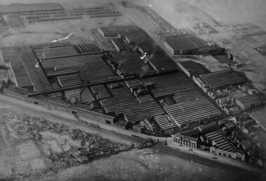
Photograph - Aerial view of HV McKay Massey Harris Factory, 1942
... Aerial view of HV McKay Massey Harris Factory building administration office and Sunshine including Sunshine Gardens and gardeners residence This photograph shows many other points of historical nature Top Left 1 Storage shed stacks of timber air drying 2 Old clock tower and new factory office block 3 Main or head office block opposite clock tower Then along Devonshire Road Adjacent to Head Office new drawing office on 1st floor over new workshop for experimental department These two later amalgamated and formed what became known as The Engineering Department Right Centre 4 on both sides of Devonshire Road 5 State Savings Bank before rebuilding 6 Blair Athol guesthouse with National Bank on ground floor opposite State Savings Bank 7 Along Hampshire away from Blair Athol some houses then McKays laboratory Duplicates department Service Street Morgue Steel Storage and Pickling Annex and Roberts Quarry and some houses in background top right Top Left to Right 8 In front of timber stacks Stony Creek winds through factory site to dam fire fighting before running under Hampshire Road in front of Annexe and Quarry across Service Street Creek was diverted through a channel and tunnel not shown Also Railway lines to Bendigo and Mildura show McKays railway engine hauling trucks from factory...McKay Massey Harris Sunshine Devonshire Road Aerial view of HV McKay Massey Harris Factory building administration office and Sunshine including Sunshine Gardens and gardeners residence This photograph shows many other points of historical nature Top Left 1 Storage shed stacks of timber air drying 2 Old clock tower and new factory office block 3 Main or head office block opposite clock tower Then along Devonshire Road Adjacent to Head Office new drawing office on 1st floor over new workshop for experimental department These two later amalgamated and formed what became known as The Engineering Department Right Centre 4 on both sides of Devonshire Road 5 State Savings Bank before rebuilding 6 Blair Athol guesthouse with National Bank on ground floor opposite State Savings Bank 7 Along Hampshire away from Blair Athol some houses then McKays laboratory Duplicates department Service Street Morgue Steel Storage and Pickling Annex and Roberts Quarry and some houses in background top right Top Left to Right 8 In front of timber stacks Stony Creek winds through factory site to dam fire fighting before running under Hampshire Road in front of Annexe and Quarry across Service Street Creek was diverted through a channel and tunnel not shown Also Railway lines to Bendigo and Mildura show McKays railway engine hauling trucks from factory Aerial view of HV McKay Massey Harris Factory Photograph Aerial view of HV McKay Massey Harris Factory ...Aerial view of HV McKay Massey Harris Factory building administration office and Sunshine including Sunshine Gardens and gardeners residence This photograph shows many other points of historical nature Top Left 1 Storage shed stacks of timber air drying 2 Old clock tower and new factory office block 3 Main or head office block opposite clock tower Then along Devonshire Road Adjacent to Head Office new drawing office on 1st floor over new workshop for experimental department These two later amalgamated and formed what became known as The Engineering Department Right Centre 4 on both sides of Devonshire Road 5 State Savings Bank before rebuilding 6 Blair Athol guesthouse with National Bank on ground floor opposite State Savings Bank 7 Along Hampshire away from Blair Athol some houses then McKays laboratory Duplicates department Service Street Morgue Steel Storage and Pickling Annex and Roberts Quarry and some houses in background top right Top Left to Right 8 In front of timber stacks Stony Creek winds through factory site to dam fire fighting before running under Hampshire Road in front of Annexe and Quarry across Service Street Creek was diverted through a channel and tunnel not shown Also Railway lines to Bendigo and Mildura show McKays railway engine hauling trucks from factoryh.v. mckay massey harris, sunshine, devonshire road -
 Sunshine and District Historical Society Incorporated
Photograph - Aerial photographs of McKay factory, 1960's
... 2 aerial views of McKay factory approximately early 1960s Photos most likely taken for Massey Ferguson showing factory building and adjacent land and shops|Photograph 1 center left McKay gardens curator's house Bendigo Railway line and ramp to Devonshire Road Second clock tower and show rooms Factory office at Russell Street entrance to factory Shops built on land once engine works machinist Portion of McKay Factory Photo taken after Massey Ferguson take over Bolt shop dismantled Land Sold for shops|Photograph 2 Aerial view of McKay Factory 1960s approximately Hampshire Road right hand side Fire station on corner of Hertford Road with Woodmill Site Later years Sunshine Plaza Shopping Centre Stony Creek still visible with garage private and car park adjacent to creek Service Street then Duplicates Building Duplicate parts of McKay factory for supply of duplicate parts Remainder of photo factory site...Sunshine Harvester Works Massey Ferguson Employ 2 aerial views of McKay factory approximately early 1960s Photos most likely taken for Massey Ferguson showing factory building and adjacent land and shops|Photograph 1 center left McKay gardens curator's house Bendigo Railway line and ramp to Devonshire Road Second clock tower and show rooms Factory office at Russell Street entrance to factory Shops built on land once engine works machinist Portion of McKay Factory Photo taken after Massey Ferguson take over Bolt shop dismantled Land Sold for shops|Photograph 2 Aerial view of McKay Factory 1960s approximately Hampshire Road right hand side Fire station on corner of Hertford Road with Woodmill Site Later years Sunshine Plaza Shopping Centre Stony Creek still visible with garage private and car park adjacent to creek Service Street then Duplicates Building Duplicate parts of McKay factory for supply of duplicate parts Remainder of photo factory site Aerial photographs of McKay factory Photograph Aerial photographs of McKay factory ...2 aerial views of McKay factory approximately early 1960s Photos most likely taken for Massey Ferguson showing factory building and adjacent land and shops|Photograph 1 center left McKay gardens curator's house Bendigo Railway line and ramp to Devonshire Road Second clock tower and show rooms Factory office at Russell Street entrance to factory Shops built on land once engine works machinist Portion of McKay Factory Photo taken after Massey Ferguson take over Bolt shop dismantled Land Sold for shops|Photograph 2 Aerial view of McKay Factory 1960s approximately Hampshire Road right hand side Fire station on corner of Hertford Road with Woodmill Site Later years Sunshine Plaza Shopping Centre Stony Creek still visible with garage private and car park adjacent to creek Service Street then Duplicates Building Duplicate parts of McKay factory for supply of duplicate parts Remainder of photo factory sitesunshine harvester works, massey ferguson, employ -
![Photograph - 1920s Sunshine streetscape, [late 1920s]](/media/collectors/5164c1772162ef0c64d700f2/items/69dc57946a5a9c1cb356da49/item-media/69dc5abd6a5a9c1cb356f072/item-fit-380x285.jpg?cb=6) Sunshine and District Historical Society Incorporated
Sunshine and District Historical Society IncorporatedPhotograph - 1920s Sunshine streetscape, [late 1920s]
... View in a north easterly direction over a house and methodist church on west and east corner of Withers Street and Devonshire Road,Sunshine Note horse-drawn vehicle on road near corner of church building view across what was known as Moons Paddock Centre left is a pool of water in Stony Creek which in later years was completely covered...Withers Devonshire Road House Sunshine Methodist Church Church View in a north easterly direction over a house and methodist church on west and east corner of Withers Street and Devonshire Road,Sunshine Note horse-drawn vehicle on road near corner of church building view across what was known as Moons Paddock Centre left is a pool of water in Stony Creek which in later years was completely covered 1920s Sunshine streetscape Photograph 1920s Sunshine streetscape ...View in a north easterly direction over a house and methodist church on west and east corner of Withers Street and Devonshire Road,Sunshine Note horse-drawn vehicle on road near corner of church building view across what was known as Moons Paddock Centre left is a pool of water in Stony Creek which in later years was completely coveredwithers, devonshire road, house, sunshine methodist church, church -
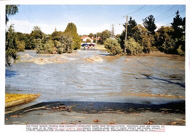 Sunshine and District Historical Society Incorporated
Photograph - Kororoit Creek in flood, Des Johnson, Copy March, 2013
... creek over Derby Road bridge between Adnerson Road and Mernda Street. High peak at 10:30am Daylight saying time people standing near end of Maye Street and Mernda Street 3 February 2005 by Des Johnson|Photocopy of photograph At Sunshine toward Ardeer concrete road bridge 7:45am Daylight light savig time looking down stream at the fast flowing stream brown colour waters under two concrete bridge supports Sunshine to Ballarat Railway line bridges 3 February 2005 by Des Johnson|Photocopy of photograph Near Stony Creek pipe outlet under Fraser Street into Kororoit Creek looking up stream of the big flood waters and the back fence of house at end of Mernda Street at 7:40am day light saving time 3 February 2005 by Des Johnson|Photocopy of photograph Between end of Fraser Street and Wridgeway Parade a rock crossing looking down stream along Kororoit Creek to end of Carter Street top middle of picture 3 February 2005 by Des Johnson...creek over Derby Road bridge between Adnerson Road and Mernda Street. High peak at 10:30am Daylight saying time people standing near end of Maye Street and Mernda Street 3 February 2005 by Des Johnson|Photocopy of photograph At Sunshine toward Ardeer concrete road bridge 7:45am Daylight light savig time looking down stream at the fast flowing stream brown colour waters under two concrete bridge supports Sunshine to Ballarat Railway line bridges 3 February 2005 by Des Johnson|Photocopy of photograph Near Stony Creek pipe outlet under Fraser Street into Kororoit Creek looking up stream of the big flood waters and the back fence of house at end of Mernda Street at 7:40am day light saving time 3 February 2005 by Des Johnson|Photocopy of photograph Between end of Fraser Street and Wridgeway Parade a rock crossing looking down stream along Kororoit Creek to end of Carter Street top middle of picture 3 February 2005 by Des Johnson Color photocopies Photograph Kororoit Creek in flood Des Johnson ...Kororoit Creek in floodPhotocopy of photograph Big flood waters flowing down Kororoit creek over Derby Road bridge between Adnerson Road and Mernda Street. High peak at 10:30am Daylight saying time people standing near end of Maye Street and Mernda Street 3 February 2005 by Des Johnson|Photocopy of photograph At Sunshine toward Ardeer concrete road bridge 7:45am Daylight light savig time looking down stream at the fast flowing stream brown colour waters under two concrete bridge supports Sunshine to Ballarat Railway line bridges 3 February 2005 by Des Johnson|Photocopy of photograph Near Stony Creek pipe outlet under Fraser Street into Kororoit Creek looking up stream of the big flood waters and the back fence of house at end of Mernda Street at 7:40am day light saving time 3 February 2005 by Des Johnson|Photocopy of photograph Between end of Fraser Street and Wridgeway Parade a rock crossing looking down stream along Kororoit Creek to end of Carter Street top middle of picture 3 February 2005 by Des Johnsonkororoit creek, sunshine, flood -
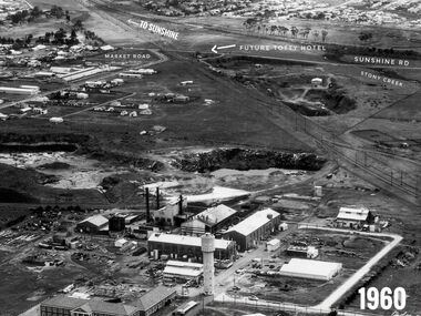 Sunshine and District Historical Society Incorporated
Photograph - Monsanta Somerville Road 1960 Photograph
... Road...Tottenham Hotel...Stony Creek...Market Road To Sunshine Future Totty Hotel Sunshine Road Stony Creek 1960...Monsanto Somerville Road Market Road Sunshine Road Tottenham Hotel Stony Creek Market Road To Sunshine Future Totty Hotel Sunshine Road Stony Creek 1960 Digital black & white photograph Photograph Monsanta Somerville Road 1960 Photograph ...Aerial photograph of Monsanto in the foreground, Market Road on left, Sunshine Road at top, the future Tottenham Hotel site which is located on the large quarry site centre top and the Sunshine to Tottenham Railway line at top.Market Road To Sunshine Future Totty Hotel Sunshine Road Stony Creek 1960monsanto, somerville road, market road, sunshine road, tottenham hotel, stony creek -
 Whitehorse Historical Society Inc.
Article, History a total mystery, 11/02/1997 12:00:00 AM
... Whitehorse Historical Society Inc. 2-10 Deep Creek Road Mitcham melbourne Aborigines McWilliam Gwen Stonier-Kipen Claire City of Boroondara Little is known about aborigines who lived in the area now known as Boroondara. ...Little is known about aborigines who lived in the area now known as Boroondara.Little is known about aborigines who lived in the area now known as Boroondara.Little is known about aborigines who lived in the area now known as Boroondara.aborigines, mcwilliam, gwen, stonier-kipen, claire, city of boroondara -
Whitehorse Historical Society Inc.
Article, Little recognition of tribe's history, 18/02/1997 12:00:00 AM
... Whitehorse Historical Society Inc. 2-10 Deep Creek Road Mitcham melbourne Notes a lack of knowledge by the public about Aboriginal history and heritage. Aborigines Nicholson Bill Patten Herb Wurundjeri Aboriginal Tribe McWilliam Gwen Stonier-Kipen Claire City of Boroondara A report commissioned by Boroondara Council. ...A report commissioned by Boroondara Council.A report commissioned by Boroondara Council notes a lack of knowledge by the public about Aboriginal history and heritage.A report commissioned by Boroondara Council. aborigines, nicholson, bill, patten, herb, wurundjeri aboriginal tribe, mcwilliam, gwen, stonier-kipen, claire, city of boroondara -
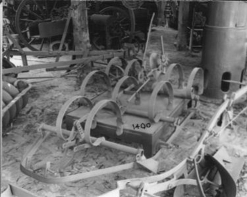 Whitehorse Historical Society Inc.
Machine - Cultivator
... Creek Road Mitcham melbourne p34 'Old Farm Machinery in Australia' Society Ref. rural industry orcharding 'Harvey' - on rear disc adjuster pivot. Horse drawn, hand operated Spring Tyne Orchard Cultivator. It can be paired with a similar cultivator. Has 7 tynes one disc at rear both adjustable. Depth of tyne into soil controlled by levers for light scratching to deep. The weight per tooth was 1/2 that of ordinary English harrow. Useful for rough stony ...p34 'Old Farm Machinery in Australia' Society Ref.Horse drawn, hand operated Spring Tyne Orchard Cultivator. It can be paired with a similar cultivator. Has 7 tynes one disc at rear both adjustable. Depth of tyne into soil controlled by levers for light scratching to deep. The weight per tooth was 1/2 that of ordinary English harrow. Useful for rough stony ground.'Harvey' - on rear disc adjuster pivot.rural industry, orcharding -
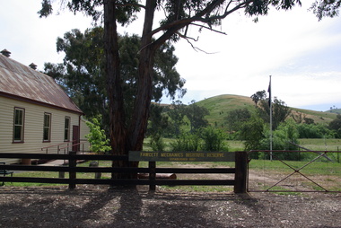 Ballarat Heritage Services
Photograph - Colour, Clare Gervasoni, Fawcett Hall and Public Library, 2015, 11/01//2015
... Fawcett Hall is 14 kilometres North West of Alexandra, North East Victoria, in Spring Creek Road and is set amongst a small picturesque rural farming and business community with hills as a backdrop and Stony Creek running alongside the public reserves property boundary. ...Ballarat Heritage Services PO Box 2209 Bakery Hill Post Office goldfields Fawcett Hall is 14 kilometres North West of Alexandra, North East Victoria, in Spring Creek Road and is set amongst a small picturesque rural farming and business community with hills as a backdrop and Stony Creek running alongside the public reserves property boundary. ...Fawcett Hall is 14 kilometres North West of Alexandra, North East Victoria, in Spring Creek Road and is set amongst a small picturesque rural farming and business community with hills as a backdrop and Stony Creek running alongside the public reserves property boundary. Part of our hall building dates back to its establishment in 1882. Originally the hall served as a Mechanics Institute and Public Library and later as a primary school.Colour photograph of a weatherboard Hall.fawcett hall and public library, fawcett, fawcett mechanics' institute -
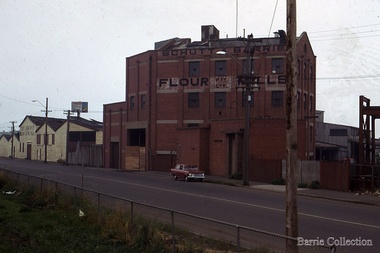 Melton City Libraries
Photograph, Schutt and Barrie Flour Mills, 1969
... His mother was born a Clutha House, stony Creek Yarraville, a was one of ten children. John Schutt opened a chaff mill at the corner of Williamstown and Geelong Roads at West Footscray. ...His mother was born a Clutha House, stony Creek Yarraville, a was one of ten children. John Schutt opened a chaff mill at the corner of Williamstown and Geelong Roads at West Footscray. ...Arthur Henry Schutt. Born 18th July 1912 at Spotswood He was the third child of John Ralph and Mary Jane Schutt. His grandfather was the first librarian of the Victorian Law Courts and his uncle, William Schutt, was a lawyer who later became the Chief Justice Sir William Schutt. His mother was born a Clutha House, stony Creek Yarraville, a was one of ten children. John Schutt opened a chaff mill at the corner of Williamstown and Geelong Roads at West Footscray. The mill was placed on in an old quarry below the ground which saved much of the backbreaking labour of heaving sheaves of hay up into the machinery, the below ground location enable the hay to be fed directly into the railway trucks into the cutters. An elevator then carried the chaff up from the ground directly into the waiting transport, at a great saving in manpower. The chaff mill became on of the largest in Victoria employing more than forty men, and later moved into flour milling.Schutt and Barrie Flour Mills, Melton South site. Opposite this Mill was a Public Weighbridge. A rail siding crossed Brooklyn road to serve chaff mill. The rail line crossed west of the Methodist Churchlocal identities, agriculture