Showing 42 items matching "storm water"
-
 Port Melbourne Historical & Preservation Society
Document, Report on the storm water drainage of Port Melbourne, 14 Jun 1904
... Report on the storm water drainage of Port Melbourne...Report on the storm-water drainage of Port Melbourne. Report to Mayor and Councillors of the Town of Port Melbourne, 1904....Report on the storm water drainage of Port Melbourne Document ...Amongst items donated to the Society by Bill Thakray.Report on the storm-water drainage of Port Melbourne. Report to Mayor and Councillors of the Town of Port Melbourne, 1904.engineering - canals and drainage, bill thakray -
Port Melbourne Historical & Preservation Society
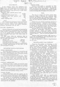
Photograph - Renewal of storm water drain, Esplanade West, Port Melbourne, Janet Bolitho, Jul 2002
... Renewal of storm water drain, Esplanade West, Port Melbourne...Five coloured photographs of renewal of storm water drain Esplanade West. .01 Esplanade East Street sign .02 Digging .03 Putting in pipe .04 large casing on end of crane .05 Workers...Port Melbourne Historical & Preservation Society Port Melbourne Town Hall 333 Bay Street Port Melbourne melbourne Built Environment - Civic Engineering - Canals and Drainage Natural Environment Sandridge Lagoon Esplanade East HMAS Lonsdale Stormwater Drain Melbourne and Metropolitan Board of Works Five coloured photographs of renewal of storm water drain Esplanade West. .01 Esplanade East Street sign .02 Digging .03 Putting in pipe .04 large casing on end of crane .05 Workers Photograph Renewal of storm water drain, Esplanade West, Port Melbourne Janet Bolitho ...Five coloured photographs of renewal of storm water drain Esplanade West. .01 Esplanade East Street sign .02 Digging .03 Putting in pipe .04 large casing on end of crane .05 Workersbuilt environment - civic, engineering - canals and drainage, natural environment, sandridge lagoon, esplanade east, hmas lonsdale, stormwater drain, melbourne and metropolitan board of works -
University of Melbourne, Burnley Campus Archives
Plan, Glenferrie PR. S. No. 1508: Detail Survey, 1982
... ...storm water...Pit Schedule of storm water and sewer pits....Pit Schedule of storm water and sewer pits. Glenferrie PR. S. ...Original and 2 copies of Public Works Department, Victoria plans of Glenferrie Primary School for the Department of Education SU 2241.2. Shows site plan of area bounded by Manningtree Road and Wattle Road. Pit Schedule of storm water and sewer pits.glenferre primary school, survey, victoria public works department, storm water, trees, p. manley (draftsman) -
Friends of Ballarat Botanical Gardens History Group
Work on paper - North Gardens Wetlands Information Notes, Friends of Ballarat Botanical Gardens (Guiding Friends Group), C 2001
... ...storm water...Important information about the North Gardens Wetlands and the primary objective of improving storm water quality....North Gardens North Gardens Wetlands North Gardens Wetlands Project Ballarat Botanical Gardens Friends of Ballarat Botanical Gardens John Garner regional indigenous plants aquatic and terrestrial plants storm water John Garner Collection Gardens Ballarat Garner None 1 page set out with subheadings. ...Important information about the North Gardens Wetlands and the primary objective of improving storm water quality.This project was completed in March 2001 and besides its ecological importance, it provides a destination at the northern end of the Gardens, creates social linkages between various environmental groups as well as improving the aesthetic standards of the site.1 page set out with subheadings.Nonenorth gardens, north gardens wetlands, north gardens wetlands project, ballarat botanical gardens, friends of ballarat botanical gardens, john garner, regional indigenous plants, aquatic and terrestrial plants, storm water, john garner collection, gardens, ballarat, garner -
 Ballarat Tramway Museum
Document - Photocopy, Neville Gower, "Mayor's Report 1955-1956", Jul. 1997
... Two pages covering trams railways, Ballarat Gas Co. and photo of new storm water drains in Wendouree Parade....Two pages covering trams railways, Ballarat Gas Co. and photo of new storm water drains in Wendouree Parade. "Mayor's Report 1955-1956" Document Photocopy Neville Gower ...Yields information about the City of Ballaarat the time of the Mayor's report to the City Council, about the events, industry, transport and other issues within the City.Photocopy of part of City of Ballaarat's Mayor's Report for 1952 - 1953. Originals held in the Ballarat Library. Two pages covering trams railways, Ballarat Gas Co. and photo of new storm water drains in Wendouree Parade.trams, tramways, city of ballaarat, trams, railways, civic history -
 Port Fairy Historical Society Museum and Archives
Photograph, Jock Varcoe
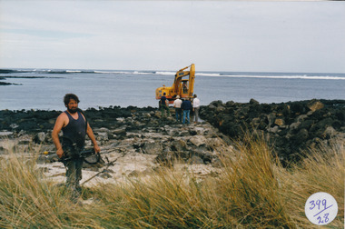
... South Beach Development drain being dug for storm water...Port Fairy Historical Society Museum and Archives 30 Gipps Street Port Fairy great-ocean-road South Beach Development drain being dug for storm water South beach development People digger drain ocean sea reef Coloured photograph of Male with brush cutter , large mechanical digger in background Photograph Photograph Jock Varcoe ...South Beach Development drain being dug for storm waterColoured photograph of Male with brush cutter , large mechanical digger in backgroundsouth beach, development, people, digger, drain, ocean, sea, reef -
 Ballarat Tramway Museum
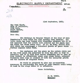
Document - Letter/s, State Electricity Commission of Victoria (SECV), 23/09/1965 12:00:00 AM
... Copy of a letter on Electricity Supply Department letterhead, quarto paper typed, from Engineer and Manager (Melbourne) to City of Ballarat, dated 23-9-1965, with a copy to the "Works Superintendent", about the condition of the drainage in Gregory St, storm water not getting away - stagnant. Signed F, K White as Manager,...Trams tramways City Of Ballarat Drainage Depot Copy of a letter on Electricity Supply Department letterhead, quarto paper typed, from Engineer and Manager (Melbourne) to City of Ballarat, dated 23-9-1965, with a copy to the "Works Superintendent", about the condition of the drainage in Gregory St, storm water not getting away - stagnant. Signed F, K White as Manager, Document Letter/s State Electricity Commission of Victoria (SECV) ...Yields information about the nature of correspondence between the SEC and the City re Council issues.Copy of a letter on Electricity Supply Department letterhead, quarto paper typed, from Engineer and Manager (Melbourne) to City of Ballarat, dated 23-9-1965, with a copy to the "Works Superintendent", about the condition of the drainage in Gregory St, storm water not getting away - stagnant. Signed F, K White as Manager,trams, tramways, city of ballarat, drainage, depot -
 Hume City Civic Collection
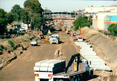
Photograph, 21/04/2005
... On the tracks the old railway lines have been removed and storm water pipes are being put into position before the new lines are to be laid....On the tracks the old railway lines have been removed and storm water pipes are being put into position before the new lines are to be laid. ...This photograph was taken during the upgrade of the Bendigo Railway line at Sunbury Station. The upgrade took twelve months to complete and during that time bus services replaced the trains.A coloured photograph of construction on the site of the Sunbury Railway Station. The photograph has been taken from the Macedon Street bridge looking south towards the station and the pedestrian bridge over the railway tracks. On the tracks the old railway lines have been removed and storm water pipes are being put into position before the new lines are to be laid.railways, bendigo line, railway stations, bridges, sunbury railway station, george evans collection -
 Greensborough Historical Society
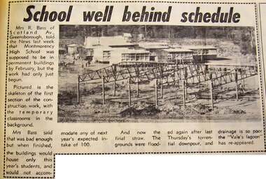
Newspaper - Newspaper Clipping - Digital Image, Diamond Valley News, School well behind schedule, and, Lake forms in school ground, 1970
... "Lake forms in school ground" (24/03/1970) shows storm water laying on the ground at the school site...."Lake forms in school ground" (24/03/1970) shows storm water laying on the ground at the school site. montmorency secondary college montmorency high school Digital copy of newspaper article School well behind schedule, and, Lake forms in school ground Newspaper Newspaper Clipping - Digital Image Diamond Valley News ...Two articles on the building of Montmorency High School (Mo8068). "School well behind schedule" (20/01/1970) describes the delay in completing the building and shows temporary classrooms behind the frame of the new building. "Lake forms in school ground" (24/03/1970) shows storm water laying on the ground at the school site.Digital copy of newspaper articlemontmorency secondary college, montmorency high school -
 Sunbury Family History and Heritage Society Inc.
Photograph, Marilyn Bray, 17th December 1985
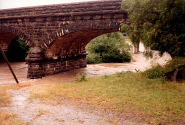
... Some of the low-lying areas in Sunbury had water flowing over the roads as a result of storm water drains overflowing. ...Some of the low-lying areas in Sunbury had water flowing over the roads as a result of storm water drains overflowing. Floods Macedon Street Bridge Jacksons Creek Sunbury A non-digital coloured photograph of flood waters rushing under a bluestone bridge. ...On 17th December 1985, Sunbury and surrounding districts experienced heavy rainfall resulting in the local rivers and waterways flooding.The floodwaters flowing under the Macedon Street bridge at Jackson Creek, almost reached the arches before the waters receded. Some of the low-lying areas in Sunbury had water flowing over the roads as a result of storm water drains overflowing. A non-digital coloured photograph of flood waters rushing under a bluestone bridge. floods, macedon street bridge, jacksons creek, sunbury -
 Kew Historical Society Inc
Photograph, J F C Farquhar, High Street, Kew, 1891
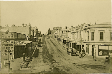
... It was unpaved and edged with deep bluestone gutters, which were designed to channel the significant flow of storm water down the hill to and beyond the Junction. ...It was unpaved and edged with deep bluestone gutters, which were designed to channel the significant flow of storm water down the hill to and beyond the Junction. ...At the beginning of the 1890s, the Kew businessman and Town Councillor, Henry Kellett, commissioned J.F.C. Farquhar to photograph scenes of Kew. These scenes included panoramas as well as pastoral scenes. The resulting set of twelve photographs was assembled in an album, Kew Where We Live, from which customers could select images for purchase.The preamble to the album describes that the photographs used the ‘argentic bromide’ process, now more commonly known as the gelatine silver process. This form of dry plate photography allowed for the negatives to be kept for weeks before processing, hence its value in landscape photography. The resulting images were considered to be finely grained and everlasting. Evidence of the success of Henry Kellett’s venture can be seen today, in that some of the photographs are held in national collections.It is believed that the Kew Historical Society’s copy of the Kellett album is unique and that the photographs in the book were the first copies taken from the original plates. It is the first and most important series of images produced about Kew. The individual images have proved essential in identifying buildings and places of heritage value in the district.In 1891, High Street was the centre of commercial activity in the Borough of Kew. It was unpaved and edged with deep bluestone gutters, which were designed to channel the significant flow of storm water down the hill to and beyond the Junction. On either side of the entrance to the shopping strip are two cast iron gas lamps that provided the only public street lighting before the Post Office was reached. Most shops, including the Nicholas Brothers’ Junction Store featured cast iron verandas. Further up the hill, Dougherty’s Greyhound Hotel was by this stage a local institution. Apart from the horse-drawn tram, the main form of personal and commercial transport in this period remained the horse, horse and cart, or buggy.The panoramic view predates the widening of High Street in the 20th century, and thus includes the original alignment of buildings on the south side. These included Henry Kellett’s shop.High Street, Kewkew illustrated, kew where we live, photographic books, henry kellett, high street - kew (vic) -
Glenelg Shire Council Cultural Collection
Film - Film - S-E Storm/ Main breakwater, Oct-63
... Front: Oct '63/ B/W S/E/Storm/Main/B/WATER/ (blue pen and white sticky tape, top of reel) Back: outside general (on paper sticky-taped to one side of reel....Glenelg Shire Council Cultural Collection History House Cliff Street Portland great-ocean-road Port of Portland Authority Port of Portland Archives Front: Oct '63/ B/W S/E/Storm/Main/B/WATER/ (blue pen and white sticky tape, top of reel) Back: outside general (on paper sticky-taped to one side of reel. ...Port of Portland AuthorityFront: Oct '63/ B/W S/E/Storm/Main/B/WATER/ (blue pen and white sticky tape, top of reel) Back: outside general (on paper sticky-taped to one side of reel.port of portland archives -
 Melbourne Tram Museum
Document - Folder with papers, Folder of memos and directions, c1940
... Folder of Memos and directions (htd3207i1> htd3207i8) - Air raid precautions, covering painting, respirators, sheds, tools, kits, shelters, stacks , blackouts, trenches, emergency, air raid shelters (htd3207i9> htd3207i16) - Accidents, covering accidents and derailments, (htd3207i17) - Bridges – inspection of Victoria St bridge (htd3207i18) - Cable tracks, covering tarring, patching, top dressing of cable tracks (htd3207i19> htd3207i21) - Cartage, covering hired trucks, cartage of wood blocks, spoil, sleepers (htd3207i22> htd3207i23) - Contracts, blank page (no image) - Councils, covering track opening, storm water drain, bad roads (htd3207i24) - Costs, covering maintenance costs, construction costs, wet weather (htd3207i25> htd3207i26) - Depots, covering inspections, storage, paving, telephones, mail (htd3207i27> htd3207i30) - Derailments, covering controls, reports (htd3207i31) - Drainage (htd3207i32) - Eastern Lines, covering loading platforms, crossovers, work orders (htd3207i33> htd3207i34) - Eastern Lines Reconstruction (htd3207i35> htd3207i37) - Eastern Line Maintenance (htd3207i38> htd3207i40) - Estimates (htd3207i41) - Employment (htd3207i42) - Footscray Lines (htd3207i43) - Instructions (htd3207i44) - Journals, covering Engineering Journal and magazines (htd3207i45) - Materials – General, covering frames & covers, unloading stores, packing plates, petrol allowance, ashes at Preston workshops, electrodes, sleepers (htd3207i46> htd3207i50) - Maintenance – General, covering loading platforms, inspections, work orders, paving (htd3207i51> htd3207i57) - Northern Lines, covering greasing of curves, crossovers, loading platforms (htd3207i58> htd3207i61) - Northern Lines – Reconstruction, covering crossings, welding machines (htd3207i62> htd3207i64) - Northern Lines – Maintenance, covering repairs, crossings, lifting programme, fencing, curves, track inspection, repairs (htd3207i65> htd3207i70) - New Lines (htd3207i71> htd3207i80) - Plant – General (htd3207i81> htd3207i94) - Plant – Concrete Mixers (htd3207i95) - Plant – Motor Vehicles (htd3207i96> htd3207i100) - Plant – Rollers (htd3207i101> htd3207i103) - Plant – Grinders (htd3207i104) - Plant – Grinders & Scrubbers (htd3207i105> htd3207i110) - Plant – Compressors and Tie Tampers (htd3207i111) - Plant – Cleaner Cars (htd3207i112> htd3207i114) - Plant – Loaders (htd3207i115) - Plant – Tools (htd3207i116> htd3207i117) - Plant – Miscellaneous (htd3207i118) - Per Way – General (htd3207i119> htd3207i121) - Public Utilities (htd3207i122> htd3207i123) - Reconstruction – General (htd3207i124> htd3207i126) - Railways (htd3207i127> htd3207i129) See \dbtext\hawthorn\photo_collections\3207_Folder for scanned images....Melbourne Tram Museum 8 Wallen Road Hawthorn melbourne Trams tramways Instructions Folder of Memos and directions (htd3207i1> htd3207i8) - Air raid precautions, covering painting, respirators, sheds, tools, kits, shelters, stacks , blackouts, trenches, emergency, air raid shelters (htd3207i9> htd3207i16) - Accidents, covering accidents and derailments, (htd3207i17) - Bridges – inspection of Victoria St bridge (htd3207i18) - Cable tracks, covering tarring, patching, top dressing of cable tracks (htd3207i19> htd3207i21) - Cartage, covering hired trucks, cartage of wood blocks, spoil, sleepers (htd3207i22> htd3207i23) - Contracts, blank page (no image) - Councils, covering track opening, storm water drain, bad roads (htd3207i24) - Costs, covering maintenance costs, construction costs, wet weather (htd3207i25> htd3207i26) - Depots, covering inspections, storage, paving, telephones, mail (htd3207i27> htd3207i30) - Derailments, covering controls, reports (htd3207i31) - Drainage (htd3207i32) - Eastern Lines, covering loading platforms, crossovers, work orders (htd3207i33> htd3207i34) - Eastern Lines Reconstruction (htd3207i35> htd3207i37) - Eastern Line Maintenance (htd3207i38> htd3207i40) - Estimates (htd3207i41) - Employment (htd3207i42) - Footscray Lines (htd3207i43) - Instructions (htd3207i44) - Journals, covering Engineering Journal and magazines (htd3207i45) - Materials – General, covering frames & covers, unloading stores, packing plates, petrol allowance, ashes at Preston workshops, electrodes, sleepers (htd3207i46> htd3207i50) - Maintenance – General, covering loading platforms, inspections, work orders, paving (htd3207i51> htd3207i57) - Northern Lines, covering greasing of curves, crossovers, loading platforms (htd3207i58> htd3207i61) - Northern Lines – Reconstruction, covering crossings, welding machines (htd3207i62> htd3207i64) - Northern Lines – Maintenance, covering repairs, crossings, lifting programme, fencing, curves, track inspection, repairs (htd3207i65> htd3207i70) - New Lines (htd3207i71> htd3207i80) - Plant – General (htd3207i81> htd3207i94) - Plant – Concrete Mixers (htd3207i95) - Plant – Motor Vehicles (htd3207i96> htd3207i100) - Plant – Rollers (htd3207i101> htd3207i103) - Plant – Grinders (htd3207i104) - Plant – Grinders & Scrubbers (htd3207i105> htd3207i110) - Plant – Compressors and Tie Tampers (htd3207i111) - Plant – Cleaner Cars (htd3207i112> htd3207i114) - Plant – Loaders (htd3207i115) - Plant – Tools (htd3207i116> htd3207i117) - Plant – Miscellaneous (htd3207i118) - Per Way – General (htd3207i119> htd3207i121) - Public Utilities (htd3207i122> htd3207i123) - Reconstruction – General (htd3207i124> htd3207i126) - Railways (htd3207i127> htd3207i129) See \dbtext\hawthorn\photo_collections\3207_Folder for scanned images. ...Folder of Memos and directions (htd3207i1> htd3207i8) - Air raid precautions, covering painting, respirators, sheds, tools, kits, shelters, stacks , blackouts, trenches, emergency, air raid shelters (htd3207i9> htd3207i16) - Accidents, covering accidents and derailments, (htd3207i17) - Bridges – inspection of Victoria St bridge (htd3207i18) - Cable tracks, covering tarring, patching, top dressing of cable tracks (htd3207i19> htd3207i21) - Cartage, covering hired trucks, cartage of wood blocks, spoil, sleepers (htd3207i22> htd3207i23) - Contracts, blank page (no image) - Councils, covering track opening, storm water drain, bad roads (htd3207i24) - Costs, covering maintenance costs, construction costs, wet weather (htd3207i25> htd3207i26) - Depots, covering inspections, storage, paving, telephones, mail (htd3207i27> htd3207i30) - Derailments, covering controls, reports (htd3207i31) - Drainage (htd3207i32) - Eastern Lines, covering loading platforms, crossovers, work orders (htd3207i33> htd3207i34) - Eastern Lines Reconstruction (htd3207i35> htd3207i37) - Eastern Line Maintenance (htd3207i38> htd3207i40) - Estimates (htd3207i41) - Employment (htd3207i42) - Footscray Lines (htd3207i43) - Instructions (htd3207i44) - Journals, covering Engineering Journal and magazines (htd3207i45) - Materials – General, covering frames & covers, unloading stores, packing plates, petrol allowance, ashes at Preston workshops, electrodes, sleepers (htd3207i46> htd3207i50) - Maintenance – General, covering loading platforms, inspections, work orders, paving (htd3207i51> htd3207i57) - Northern Lines, covering greasing of curves, crossovers, loading platforms (htd3207i58> htd3207i61) - Northern Lines – Reconstruction, covering crossings, welding machines (htd3207i62> htd3207i64) - Northern Lines – Maintenance, covering repairs, crossings, lifting programme, fencing, curves, track inspection, repairs (htd3207i65> htd3207i70) - New Lines (htd3207i71> htd3207i80) - Plant – General (htd3207i81> htd3207i94) - Plant – Concrete Mixers (htd3207i95) - Plant – Motor Vehicles (htd3207i96> htd3207i100) - Plant – Rollers (htd3207i101> htd3207i103) - Plant – Grinders (htd3207i104) - Plant – Grinders & Scrubbers (htd3207i105> htd3207i110) - Plant – Compressors and Tie Tampers (htd3207i111) - Plant – Cleaner Cars (htd3207i112> htd3207i114) - Plant – Loaders (htd3207i115) - Plant – Tools (htd3207i116> htd3207i117) - Plant – Miscellaneous (htd3207i118) - Per Way – General (htd3207i119> htd3207i121) - Public Utilities (htd3207i122> htd3207i123) - Reconstruction – General (htd3207i124> htd3207i126) - Railways (htd3207i127> htd3207i129) See \dbtext\hawthorn\photo_collections\3207_Folder for scanned images.trams, tramways, instructions -
 Eltham District Historical Society Inc
Photograph - Digital Photograph, Alan King, Diamond Creek, Barak Bushlands, Eltham, 2008
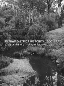
... The beautiful wetland treats most of the estate’s stormwater runoff. Storm water is filtered through plants in the wetland ponds then is released slowly into the billabong, before flowing into the Diamond Creek. ...The beautiful wetland treats most of the estate’s stormwater runoff. Storm water is filtered through plants in the wetland ponds then is released slowly into the billabong, before flowing into the Diamond Creek. ...A habitat corridor and it strengthens the community. Published: Nillumbik Now and Then / Marguerite Marshall 2008; photographs Alan King with Marguerite Marshall.; p185 Barak Bushlands lie west of the Diamond Creek on the corner of Falkiner Street and busy, noisy Main Road. They form part of an important habitat corridor linking the Yarra River to the Kinglake National Park.1 Manna Gums, tawny frogmouths and platypuses are some of the indigenous plants and animals that have made their home there. The bushlands are the result of more than nine years of hard work by the local community with the Nillumbik Council, to transform a degraded flood plain into this refuge of natural beauty. In 1997, shortly after moving into the new Riverside Estate on Falkiner Street, Eltham, several residents noticed the sorry state of the Diamond Creek and surrounding area. Part of it was used as a cow paddock and although small patches of vegetation survived, the area was infested with weeds, rabbits, rubbish and drainage from the housing estate. At various times the 4.4 hectares had been used as a market garden and for shire stock piles. The residents began to restore the area by revegetating land along the Diamond Creek. In 1998 they established the Friends of the Diamond Creek Falkiner Street Reserve2 and 35 families joined from the 90-house Estate. Carolyn Mellor, as the Friends’ Land Manager, undertook a four-year horticulture course to guide this massive project for a volunteer organisation. Since 1999, she has been the Friends’ President. In 1999 the Friends urged the Nillumbik Council to undertake a feasibility study into establishing a wetland system and urban forest. Work began in 2002 with Nillumbik Council funding the project, supplemented by government grants. The Friends also received grants from Melbourne Water and Parks Victoria. Aided by the Friends and other community members, the Council created the Barak Bushlands consisting of a forest, a wetland, a bridge, a path and open space. The beautiful wetland treats most of the estate’s stormwater runoff. Storm water is filtered through plants in the wetland ponds then is released slowly into the billabong, before flowing into the Diamond Creek. The wetland also helps to minimise flooding and the improved water quality provides a flora and fauna habitat. The Friends and other volunteers planted more than 27,000 plants, more than one third of which they grew from seeds they collected at Lower Eltham and Wingrove Parks. Eltham High School students planted thousands of these through a Year Eight program introduced for this purpose. Other groups who assisted were: Green Corps, local Scouts and Guides – 2nd Montmorency, 1st Diamond Creek and 1st Eltham Cub Packs, Eltham College students, Eltham East Primary School, Landcare members, Eltham Lions Club and the Eltham Baptist Church. To maintain enthusiasm for the mammoth task, the Friends and other volunteers ‘adopted’ trees to water and wrote their names on the stakes. In 2004, to recognise the area’s original occupiers, the reserve was named Barak Bushlands. William Barak, who lived from 1824 to 1903, was the last chief of the Yarra Yarra tribe of the Wurundjeri-willam people. Traces of these original inhabitants remain in scar trees (bark sections removed to make a shield or canoe). That same year the Friends’ group was a finalist in the prestigious Federal Government, Banksia Environmental Awards. The Friends have also participated in Clean Up Australia, removing tonnes of rubbish and regularly testing the billabong, wetland and creek, for pollutants. For years the Friends, together with the Australian Platypus Conservancy, have tagged, measured and checked the health of platypuses from the Diamond and Mullum Mullum Creeks. With Latrobe University the Friends have conducted night walks to view owls, possums, bats and sugar gliders. Challenges for the council and the Friends continue with a large rabbit population, some vandalism, weed eradication and maintenance. However, thanks to this community effort, locals can now escape confined urban living on small blocks of land and enjoy the beauty of indigenous plants and animals. Working together has also strengthened the local community,This collection of almost 130 photos about places and people within the Shire of Nillumbik, an urban and rural municipality in Melbourne's north, contributes to an understanding of the history of the Shire. Published in 2008 immediately prior to the Black Saturday bushfires of February 7, 2009, it documents sites that were impacted, and in some cases destroyed by the fires. It includes photographs taken especially for the publication, creating a unique time capsule representing the Shire in the early 21st century. It remains the most recent comprehenesive publication devoted to the Shire's history connecting local residents to the past. nillumbik now and then (marshall-king) collection, barak bushlands, diamond creek (creek), eltham -
 Bendigo Historical Society Inc.
Newspaper - Newspaper articles by Ken Arnold, Out &About, 2000 - 2003
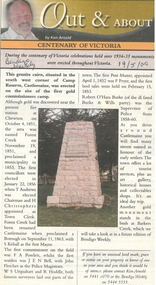
... Centenary of Victoria 19.5.00 2. Storm Water Drain 26.5.00 3. Granite Rollers 2.6.00 4. ...Centenary of Victoria 19.5.00 2. Storm Water Drain 26.5.00 3. Granite Rollers 2.6.00 4. ...Ken Arnold is a Bendigo author and publisher.A series of one hundred and thirty-five articles written by Ken Arnold and published in the Bendigo Weekly between 2000 and 2003. Each article has a topic or theme and includes historical information and details. Each article includes a photograph. The articles are stored in a red vinyl covered two ring A5 folder. Index below. Number Article Name Date 1. Centenary of Victoria 19.5.00 2. Storm Water Drain 26.5.00 3. Granite Rollers 2.6.00 4. Poverty Mine 9.6.00 5. Golden Monument. St Arnaud 16.6.00 6. Turner Statue 7.7.00 7. Gold Monument. High St Golden Square 30.6.00 8. Gold Monument. Howard Square Bendigo 14.7.00 9. Lansell Statue 21.7.00 10. Shelbourne West School 18.8.00 11. Mologa’s State Schools 25.8.00 12. Salinity Stone. Pyramid Hill 1.9.00 13. Cairn. Carisbrook 8.9.00 14. Commemorative Markers. Taradale 15.9.00 15. Burke Monument. Castlemaine 22.9.00 16. Cairn. Harcourt area 29.9.00 17. Cairn Marks Gold Route 6.10.00 18. Volcanic Rock Cairn. Woodstock 13.10.00 19. Garfield Water Wheel 20.10.00 20. Anticline. Castlemaine 27.10.00 21. Lawson Bridge 10.11.00 22. Plaque. Sutton Grange area 17.11.00 23. Memorial Cairn. Maryborough 1.12.00 24. Lonely Grave 8.12.00 25. Moonlight Flat Church 5.1.01 26. Historic Church. Near Tullaroop reservoir 12.1.01 27. Granite Statue. Castlemaine 19.1.01 28. Marker. Near Tullaroop reservoir 25.1.01 29. Church Site. Mologa 2.2.01 30. Church Site. Mologa 9.2.01 31. Plaque. Mologa 16.2.01 32. Mincha School 23.2.01 33. Historic Marker. Mincha 2.3.01 34. Expedition Marker. Pyramid Hill 9.3.01 35. Irrigation Marker. Tragowel 16.3.01 36. Mologa School Sites 23.3.01 37. Cairn. Pyramid Hill 30.3.01 38. Plaque. Pyramid Hill 6.4.01 39. Bristol Hill Lookout Tower. Maryborough 12.4.01 40. Eppalock Reservoir 20.4.01 41. Colbinabbin Cairn 27.4.01 42. Mount Macedon Cross 4.5.01 43. Memorial Gateway. Macedon 11.5.01 44. Cairn. Daylesford 18.5.01 45. Grave. Carlsruhe 25.5.01 46. Water Tower. Elmore 1.6.01 47. State School Site. Glenalbyn 8.6.01 48. Cairn. Kanya 15.6.01 49. Lonely Grave. Wedderburn 22.6.01 50. Church Cairn. Glenalbyn 29.6.01 51. Kamarooka School 6.7.01 52. Granite Marker. Moyston 13.7.01 53. Memorial Park. Kerang 20.7.01 54. Water Plaque. Bears Lagoon 27.7.01 55. Cemetery. Bears Lagoon 3.8.01 56. Race Monument 10.8.01 57. Cairn. Pyalong 17.8.01 58. Cairn. In memory of Edward Parker 24.8.01 59. Mt Macedon 31.8.01 60. Mt Macedon Cairn 7.9.01 61. Expedition Pass. Chewton 14.9.01 62. Granite Archway. St Arnaud 21.9.01 63. Stuart Mill School Site 28.9.01 64. School Site. Beazley’s Bridge 5.10.01 65. Fosterville 12.10.01 66. Barnadown 19.10.01 67. Salisbury School Site 26.10.01 68. Cricket History at Wattle Flat 2.11.01 69. School Site. Waterloo Plains 9.11.01 70. Carapooee School Site 11.01 71. Turkish Gun. Maldon 11.01 72. Kooreh 30.11.01 73. Marnoo East School 7.12.01 74. Bulgana Site 14.12.01 75. Emu School 21.12.01 76. Kooroocheang 4.1.02 77. Church Site. Gre Gre North 11.1.02 78. Carmens Tunnel. Maldon 18.1.02 79. Monument. Maldon 25.1.02 80. Woodfull Plaques. Maldon 1.2.02 81. Carapooee. St Peters Anglican Church 8.2.02 82. Cairn. Kingower 15.2.02 83. Cob & Co Stopover. Rheola 22.2.02 84. Flynn Monument 1.3.02 85. The Welcome Stranger. Moliagul 8.3.02 86. Campbell’s Creek Reserve 15.3.02 87. Mine. Fryerstown 22.3.02 88. Escott Grave. Near Chewton 28.3.02 89. School No 808. Kurting area 5.4.02 90. Graves. Bendigo Creek 10.5.02 91. School. Fish Point, Benjeroop North 17.5.02 92. Old Township. Diggora 24.5.02 93. Diggora West (1) 31.5.02 94. Diggora West (2) 7.6.02 95. School No 2735. Gower East 14.6.02 96. Pannoomilloo 21.6.02 97. Kamarooka Settlement 28.6.02 98. Mincha West State School No 1931 5.7.02 99. Bridges. Arnold 12.7.02 100. Woodvale 19.7.02 101. A Famous Son of Raywood. Jack Donaldson 26.7.02 102. Tandarra Area Schools 2.8.02 103. Dingee 9.8.02 104. Avonmore 30.8.02 105. Myola East School 6.9.02 106. Colbinabbin West 13.9.02 107. Colbinabbin West School 20.9.02 108. Runnymede area 27.9.02 109. Wanalta 4.10.02 110. School Sites. Between Wanalta and Carop 11.10.02 111. Burramboot 18.10.02 112. Kangaroo Chair. 25.10.02 113. Mincha South 1.11.02 114. Woodlands Church 8.11.02 115. School site. Sylvaterre 15.11.02 116. Terrick Terrick 22.11.02 117. Leitchville 29.11.02 118. Pennyweight Cemetery. Castlemaine 6.12.02 119. Mincha Area 13.12.02 120. Musk School 20.12.02 121. Dowie Park. Carisbrook 3.1.03 122. Neereman School Site 10.1.03 123. Bald Rock 17.1.03 124. Sylvaterre School Site 24.1.02 125. Carlsruhe 31.1.02 126. Athenaeum. Maldon 7.2.03 127. School. Mincha West 14.2.03 128. Yarraberb 21.2.03 129. Settlement Marker. Ravenswood Estate 28.2.03 130. Comini Reserve. Ravenswood 7.3.03 131. Ironbark and Gold Track. Whroo 14.3.03 132. Burke and Wills Obelisk. Castlemaine 21.3.03 133. James Cook Statue. Myers St Bendigo 28.3.03 134. St Marys Church. Axedale 4 .4.03 135. Butter Factory Site. Warragamba 11.4.03 events, monuments, historical sites, landmarks -
 Kiewa Valley Historical Society
Fire Fighting Back Packs x2
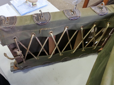
... water proof materials and used to carry supplies and equipment for firemen. Designed to protect the contents in all weather and to be as comfortable and practical as possible enabling the firemen to go into bush that fire trucks couldn't access. The Kiewa Hydro Electric Scheme was constructed on the Bogong High Plains, in the bush where bush fires were common especially after a storm ...Made from water proof materials and used to carry supplies and equipment for firemen. Designed to protect the contents in all weather and to be as comfortable and practical as possible enabling the firemen to go into bush that fire trucks couldn't access.The Kiewa Hydro Electric Scheme was constructed on the Bogong High Plains, in the bush where bush fires were common especially after a storm with lightening.Canvas back packs with a flap at the front and 2 straps at the back. The sides have a wooden stick with a zig zag webbing attached.On the flap of each - printed in black: 22 / crew leader / No 1 21 / fire bossfiefighting, firemen, back packs -
4th/19th Prince of Wales's Light Horse Regiment Unit History Room
Photograph collection, Palestine Campaign, not known
... watering horses at "Jenin". 3. German and Turkish prisoners captured at "Jenin" 4. Abandoned enemy transport at Nazareth Hill 5. "Nazareth". Cavalry in occupation 6. "After the charge. By 4th A.L.H. Bde at Semakh 7. "Semakh station" A scene of German treachery 8. 8th A.L.H. bivouaced near Galilee 9. Coming Storm...watering horses at "Jenin". 3. German and Turkish prisoners captured at "Jenin" 4. Abandoned enemy transport at Nazareth Hill 5. "Nazareth". Cavalry in occupation 6. "After the charge. By 4th A.L.H. Bde at Semakh 7. "Semakh station" A scene of German treachery 8. 8th A.L.H. bivouaced near Galilee 9. Coming Storm ...Set of 24, A3 prints of photographs relating to the Palestinian campaign of World War 1. In A3 museum quality presentation binder. Photo captions: Cover. The final drive Jerusalem to Damascus September 1918 (print not included). 1. "German Aviator's memorial "Jenin". 2. British and Indian cavalry watering horses at "Jenin". 3. German and Turkish prisoners captured at "Jenin" 4. Abandoned enemy transport at Nazareth Hill 5. "Nazareth". Cavalry in occupation 6. "After the charge. By 4th A.L.H. Bde at Semakh 7. "Semakh station" A scene of German treachery 8. 8th A.L.H. bivouaced near Galilee 9. Coming Storm "Sea of Galilee" 10. A picnic on the shore of Galilee 11. Ruins of Capernaum 12. Bedouin children. "Capernaum". 13 Jisr Benat Yakub (Bridge of Jacob's Daughter) upper Jordan 14 Examining prisoners "Benat Yakub" 15 Moving up, Motor Lorries with material for repairing Bridge "Benat Jacob". 16 Kuneitra 17. Aus Div staff with Headmen of "Kuneitra". 18 Hedjaz forces entering "Damascus" 19 Light Horsemen entering "Damascus". 20 L.A.M.B. entering Damascus 21 Inhabitants inspecting Motor cyclists "Damascus". 22 Portion of "Damascus" square Day of occupation 23 Prisoners herded in Damascus square 24 The morning after "Barada Gorge Damascus" -
 Lara RSL Sub Branch
Statement By Eric George Elliott on the Light Horse Brigade charge at Beersheba
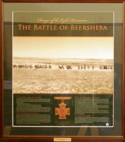
... stormed through the Turkish defences and seized the strategic town of Beersheba. The capture of Beersheba enabled British Empire forces to break the Ottoman line near Gaza on 7 November and advance into Palestine. Decisive victory at Beersheba fell to one of the last great charges of mounted troops in history. As Australian Light Horse Divisions captured the town and secured crucial water ...This statement by Eric George Elliott tells how The battle of Beersheba took place on 31 October 1917 as part of the wider British offensive collectively known as the third Battle of Gaza. The final phase of this all day battle was the famous mounted charge of the 4th Light Horse Brigade. Commencing at dusk, members of the brigade stormed through the Turkish defences and seized the strategic town of Beersheba. The capture of Beersheba enabled British Empire forces to break the Ottoman line near Gaza on 7 November and advance into Palestine.Decisive victory at Beersheba fell to one of the last great charges of mounted troops in history. As Australian Light Horse Divisions captured the town and secured crucial water wells, their success also marked the beginning of the end of the war in the Middle East. This end came exactly a year to the day after success at Beersheba.Rectangular shaped glass covered picture frame with a photocopy of his statement on the charge of Beersheba.ww!, beersheba, statement, photocopy, australian light horse brigade. -
 Lara RSL Sub Branch
Photograph, Battle of Beersheba - Limited Edition of 1917, Rememberance Day 2008
... stormed through the Turkish defences and seized the strategic town of Beersheba. The capture of Beersheba enabled British Empire forces to break the Ottoman line near Gaza on 7 November and advance into Palestine. Decisive victory at Beersheba fell to one of the last great charges of mounted troops in history. As Australian Light Horse Divisions captured the town and secured crucial water ...The battle of Beersheba took place on 31 October 1917 as part of the wider British offensive collectively known as the third Battle of Gaza. The final phase of this all day battle was the famous mounted charge of the 4th Light Horse Brigade. Commencing at dusk, members of the brigade stormed through the Turkish defences and seized the strategic town of Beersheba. The capture of Beersheba enabled British Empire forces to break the Ottoman line near Gaza on 7 November and advance into Palestine.Decisive victory at Beersheba fell to one of the last great charges of mounted troops in history. As Australian Light Horse Divisions captured the town and secured crucial water wells, their success also marked the beginning of the end of the war in the Middle East. This end came exactly a year to the day after success at Beersheba.Rectangular shaped glass covered picture frame showing the Light Horsemen.Charge of the Light Horsemen The Battle of Beershebabeersheba, the light horse, lara r.s.l.,world war one, battle of beersheba, ww1 -
 Eltham District Historical Society Inc
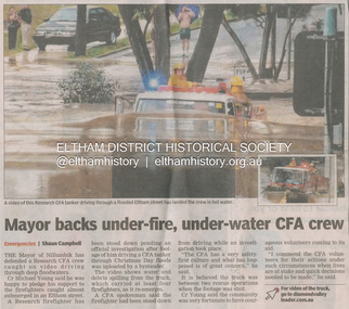
Newsclipping, Shaun Campbell, Mayor backs under-fire, under-water CFA crew, Diamond Valley Leader, December 2011
... storm on Christmas Day 2011. A flash flood occurred from significant rain fall and hail, which accumulated along an old waterway with floodwater submerging cars along Valonia Drive then down Grove Street flooding houses, through the Bible Street Reserve where it then submerged Main Road washing away the small railway trestle bridge opposite the reserve then flooding the Judge Book Village before finally entering the Diamond Creek. Widespread damage occured from hail and flash flooding. Fay Bridge Collection Eltham Flood damage floods Floodwater Main Road Research Fire Brigade Digital file - scanned from newsclipping on loan Mayor backs under-fire, under-water ...A late afternoon storm on Christmas Day 2011. A flash flood occurred from significant rain fall and hail, which accumulated along an old waterway with floodwater submerging cars along Valonia Drive then down Grove Street flooding houses, through the Bible Street Reserve where it then submerged Main Road washing away the small railway trestle bridge opposite the reserve then flooding the Judge Book Village before finally entering the Diamond Creek. Widespread damage occured from hail and flash flooding.fay bridge collection, eltham, flood damage, floods, floodwater, main road, research fire brigade -
 Eltham District Historical Society Inc
Book, Diamond Creek Basin Study. Part 1, A Compendium of Factors Relevant to Stormwater Flows, 1980
... storm sewers...stormwater...sugarloaf-preston transfer main crossing...susan street...union mine...village pond...water...Eltham District Historical Society Inc 728 Main Rd Eltham melbourne Basin Studies are studies to evaluate water supply and demand and help ensure reliable water supplies by identifying strategies to address imbalances in water supply and demand. aerial photographs allendale road arthurs creek mine arthurs creek road bridge arthurs creek bald spur look-out bank protection bolton steet bridge street bridge bridge street bridges challenger street chute street construction coolaroo drive culvert deep creek diamond creek basin diamond creek region diamond creek diamond street bridge drainage works eltham lower park eltham town park eltham trestle bridge eltham west drains eltham erosion flood management floods footbridge glen katherine estate gold mining gum glade hurstbridge kangaroo ground kinglake escarpment kinglake national park latiners hat factory main road bridge main road masons falls melbourne metropolitan board of works, monash bridge mount sugarloaf nillumbik park orchards railway culvert railway line ramptons road real estate advertisement research creek st helena east drain st helena road st helena storm sewers stormwater sugarloaf-preston transfer main crossing susan street union mine village pond water flow watkins street wattletree road weidlich road wingrove park yarra river zig zag road water supply basin study Spiral Bound. 157 leaves in various foliations (some folded) : illustrated. ...Basin Studies are studies to evaluate water supply and demand and help ensure reliable water supplies by identifying strategies to address imbalances in water supply and demand.Spiral Bound. 157 leaves in various foliations (some folded) : illustrated. (some colour.), maps (some colour.)aerial photographs, allendale road, arthurs creek mine, arthurs creek road bridge, arthurs creek, bald spur look-out, bank protection, bolton steet, bridge street bridge, bridge street, bridges, challenger street, chute street, construction, coolaroo drive, culvert, deep creek, diamond creek basin, diamond creek region, diamond creek, diamond street bridge, drainage works, eltham lower park, eltham town park, eltham trestle bridge, eltham west drains, eltham, erosion, flood management, floods, footbridge, glen katherine estate, gold mining, gum glade, hurstbridge, kangaroo ground, kinglake escarpment, kinglake national park, latiners hat factory, main road bridge, main road, masons falls, melbourne metropolitan board of works, monash bridge, mount sugarloaf, nillumbik park, orchards, railway culvert, railway line, ramptons road, real estate advertisement, research creek, st helena east drain, st helena road, st helena, storm sewers, stormwater, sugarloaf-preston transfer main crossing, susan street, union mine, village pond, water flow, watkins street, wattletree road, weidlich road, wingrove park, yarra river, zig zag road, water supply, basin study -
 Eltham District Historical Society Inc
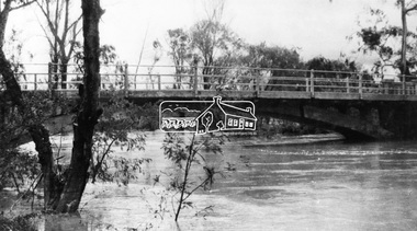
Negative - Photograph, Diamond Creek floodwater at Monash Bridge, Hurstbridge, Dec. 1934
... The historic 1934 flood of the Diamond Creek and Yarra River following the storms of 29-30 November set the levels for future planning with respect to flood water rise....Eltham District Historical Society Inc 728 Main Rd Eltham melbourne The historic 1934 flood of the Diamond Creek and Yarra River following the storms of 29-30 November set the levels for future planning with respect to flood water rise. ...The historic 1934 flood of the Diamond Creek and Yarra River following the storms of 29-30 November set the levels for future planning with respect to flood water rise.This photo forms part of a collection of photographs gathered by the Shire of Eltham for their centenary project book,"Pioneers and Painters: 100 years of the Shire of Eltham" by Alan Marshall (1971). The collection of over 500 images is held in partnership between Eltham District Historical Society and Yarra Plenty Regional Library (Eltham Library) and is now formally known as the 'The Shire of Eltham Pioneers Photograph Collection.' It is significant in being the first community sourced collection representing the places and people of the Shire's first one hundred years.Digital image 4 x 5 inch B&W Negshire of eltham pioneers photograph collection, hurstbridge, 1934 flood, floods, monash bridge, diamond creek (creek) -
 Bendigo Historical Society Inc.
Newspaper - NEWSPAPER COLLECTION: BENDIGO ADVERTISER - HERALD SUN 2009 BUSHFIRES
... 1) The Advertiser - Red Alert - February 06, 2009 2) The Advertiser - Headline Moments of the Past-July 03, 2009 3) Herald Sun - Black Saturday - February 07, 2009 4) Herald Sun - Fire-storm - February 08, 2009 5) Herald Sun - 84 Dead - February 09, 2009 6) Herald Sun - We'll Help - February 09, 2009 7) The Advertiser - Hellfire Heartache - February 09, 2009 8) The Advertiser - Thumbs Up On Water - February 09, 2009 9) Herald Sun - We Will Rebuild - February 10, 2009 10) Herald Sun - All Lost - February 10, 2009 11) The Advertiser - How We Lost Our Brother - February 10, 2009 12) The Advertiser - Counting the Cost - February 10, 2009 13) Herald Sun - Alive - February 11, 2009 14) Herald Sun - Act of Terror - February 11, 2009 15) Herald Sun - Never Again - February 12, 2009 16) Herald Sun - The Tiniest Victims - February 12, 2009 17) Herald Sun - Heart of a Nation - February 13, 2009 18) Bendigo Weekly - City Unites - February 13, 2009 19) Herald Sun - Love from the Ashes - February 14, 2009 20) The Advertiser - Black Saturday - February 14, 2009 21) The Advertiser - Black Saturday - February 14, 2009 22) Herald Sun - Portraits of Grief - February 14, 2009 23) Herald Sun - Salute Our Heroes - February 15, 2009 24) The Advertiser - One Brick at the Time - February 16, 2009. ...History House 11 Mackenzie Street Bendigo goldfields NEWSPAPER Bendigo Advertiser 1) The Advertiser - Red Alert - February 06, 2009 2) The Advertiser - Headline Moments of the Past-July 03, 2009 3) Herald Sun - Black Saturday - February 07, 2009 4) Herald Sun - Fire-storm - February 08, 2009 5) Herald Sun - 84 Dead - February 09, 2009 6) Herald Sun - We'll Help - February 09, 2009 7) The Advertiser - Hellfire Heartache - February 09, 2009 8) The Advertiser - Thumbs Up On Water - February 09, 2009 9) Herald Sun - We Will Rebuild - February 10, 2009 10) Herald Sun - All Lost - February 10, 2009 11) The Advertiser - How We Lost Our Brother - February 10, 2009 12) The Advertiser - Counting the Cost - February 10, 2009 13) Herald Sun - Alive - February 11, 2009 14) Herald Sun - Act of Terror - February 11, 2009 15) Herald Sun - Never Again - February 12, 2009 16) Herald Sun - The Tiniest Victims - February 12, 2009 17) Herald Sun - Heart of a Nation - February 13, 2009 18) Bendigo Weekly - City Unites - February 13, 2009 19) Herald Sun - Love from the Ashes - February 14, 2009 20) The Advertiser - Black Saturday - February 14, 2009 21) The Advertiser - Black Saturday - February 14, 2009 22) Herald Sun - Portraits of Grief - February 14, 2009 23) Herald Sun - Salute Our Heroes - February 15, 2009 24) The Advertiser - One Brick at the Time - February 16, 2009. ...1) The Advertiser - Red Alert - February 06, 2009 2) The Advertiser - Headline Moments of the Past-July 03, 2009 3) Herald Sun - Black Saturday - February 07, 2009 4) Herald Sun - Fire-storm - February 08, 2009 5) Herald Sun - 84 Dead - February 09, 2009 6) Herald Sun - We'll Help - February 09, 2009 7) The Advertiser - Hellfire Heartache - February 09, 2009 8) The Advertiser - Thumbs Up On Water - February 09, 2009 9) Herald Sun - We Will Rebuild - February 10, 2009 10) Herald Sun - All Lost - February 10, 2009 11) The Advertiser - How We Lost Our Brother - February 10, 2009 12) The Advertiser - Counting the Cost - February 10, 2009 13) Herald Sun - Alive - February 11, 2009 14) Herald Sun - Act of Terror - February 11, 2009 15) Herald Sun - Never Again - February 12, 2009 16) Herald Sun - The Tiniest Victims - February 12, 2009 17) Herald Sun - Heart of a Nation - February 13, 2009 18) Bendigo Weekly - City Unites - February 13, 2009 19) Herald Sun - Love from the Ashes - February 14, 2009 20) The Advertiser - Black Saturday - February 14, 2009 21) The Advertiser - Black Saturday - February 14, 2009 22) Herald Sun - Portraits of Grief - February 14, 2009 23) Herald Sun - Salute Our Heroes - February 15, 2009 24) The Advertiser - One Brick at the Time - February 16, 2009. Folder 111 now in Box 417 AV 03/11/2022newspaper, bendigo advertiser -
 Queenscliffe Maritime Museum
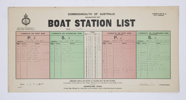
Document - Form, Boat Station List
... Wreck visible until early 1960s, until during a storm it slid off northern side of Nepean reef and broke up in 20 feet of water. ...Wreck visible until early 1960s, until during a storm it slid off northern side of Nepean reef and broke up in 20 feet of water. ...The Court of Marine Inquiry found that the steering gear had failed as the SS Time entered Port Phillip Heads. It was established that the fault lay with the Lloyd's surveyor for not detecting the fault when the Time had been classified Al. No blame was attached to the master. Two Queenscliff fishermen purchased weck for 950 pounds (insured value 30,000 pounds)and its timber cargo - handsome profit. Cargo and most fittings of value recovered. Wreck visible until early 1960s, until during a storm it slid off northern side of Nepean reef and broke up in 20 feet of water. The most noteworthy shipwreck to date at the heads.Two Queenscliff fishermen purchased the weck for 950 pounds (insured value 30,000 pounds) and its timber cargo - handsome profit. The cargo and most of the fittings of value were recovered. The wreck was visible until the early 1960s, until during a storm, it slid off the northern side of Nepean Reef and broke up in 20 feet of water. The most noteworthy shipwreck to date at the heads.A Commonwealth of Australia Navigation Act, Boat Station List form, showing the names of crew assigned to each of 4 lifeboats on the Port [P] and Starboard [S] sides of the SS Time dated 1 August 1949.Form C.B.D.F 3 for 4 lifeboats; Boat Station List navigation act, ss time, port phillip, shipwrecks, lifeboat rules -
Queenscliffe Maritime Museum
Equipment - Engine room telegraph
... Wreck visible until early 1960s, until during a storm it slid off northern side of Nepean reef and broke up in 20 feet of water. ...Wreck visible until early 1960s, until during a storm it slid off northern side of Nepean reef and broke up in 20 feet of water. ...Court of Marine Inquiry found that steering gear had failed as vessel entered Heads. Fault lay with Lloyd's surveyor for not detecting fault. Vessel had been classified Al. No blame attachable to master. Two Queenscliff fishermen purchased wreck for 950 pounds (insured value 30,000 pounds)and its timber cargo - handsome profit. Cargo and most fittings of value recovered. Wreck visible until early 1960s, until during a storm it slid off northern side of Nepean reef and broke up in 20 feet of water. The most noteworthy shipwreck to date at the heads.Ship's engine room telegraph from bridge of SS TimeChadburns ship's telegraph manufacturersss time, wrecks, marine telegraph -
 Bendigo Historical Society Inc.
Document - EXTRACT FROM BENDIGO ADVERTISER, JANUARY 4TH 1864: (SEVERE STORM), 04/01/1864
... Storm) with attached typed note stating that this extract found in relation to the ''heavy rain fall in February last'' (no date! - but about ''a century ago'). Mention in this note that the hotel mentioned - Costello's Axe Creek Bridge Hotel may have been later renamed The Perseverence (sic). The 1864 article describes the water...Storm) with attached typed note stating that this extract found in relation to the ''heavy rain fall in February last'' (no date! - but about ''a century ago'). Mention in this note that the hotel mentioned - Costello's Axe Creek Bridge Hotel may have been later renamed The Perseverence (sic). The 1864 article describes the water ...Extract from Bendigo Advertiser, January 4th, 1864 (Severe Storm) with attached typed note stating that this extract found in relation to the ''heavy rain fall in February last'' (no date! - but about ''a century ago'). Mention in this note that the hotel mentioned - Costello's Axe Creek Bridge Hotel may have been later renamed The Perseverence (sic). The 1864 article describes the water and ice/hail damage in the neighborhood of the Sheepwash, Emu and Axe Creeks.Bendigo Advertisernewspaper, bendigo advertiser, weather event, emu and axe creeks, axe creek bridge hotel -
 Bendigo Historical Society Inc.
Document - VARIOUS ARTICLES FOR SOCIETY NEWSLETTER, DECEMBER 1971
... storm and later removed. Source of information for this item attributed to Misses D and D Davenpor, London and the Bendigo Advertiser; handwritten notes re this same article. 4. ''Boys will be boys'' by Mr A Richardson - article based on Annual Report of the Secretary for Mines and Water Supply, 1885 re 11 year old lad who fell down mine; handwritten notes on same article. ...storm and later removed. Source of information for this item attributed to Misses D and D Davenpor, London and the Bendigo Advertiser; handwritten notes re this same article. 4. ''Boys will be boys'' by Mr A Richardson - article based on Annual Report of the Secretary for Mines and Water Supply, 1885 re 11 year old lad who fell down mine; handwritten notes on same article. ...Various articles for Newsletter ('Marunari??) for November???? 1. Re Jack Moorhead (''the most competent engine driver in the Bendigo field'') with handwritten copy of same; 2. 3 pages of handwritten notes for inclusion in the newsletter - various topics; 3. ''The Canons (sic) on Camp Hill'' - history of the Lookout Tower site and flag post, cannons and statue - semi-nude lady - which was damaged in storm and later removed. Source of information for this item attributed to Misses D and D Davenpor, London and the Bendigo Advertiser; handwritten notes re this same article. 4. ''Boys will be boys'' by Mr A Richardson - article based on Annual Report of the Secretary for Mines and Water Supply, 1885 re 11 year old lad who fell down mine; handwritten notes on same article. Various articles for Society newsletter, December 1971; 1. Handwritten note for end of year from President, Neil Murray; 2. Typewritten page titled '' Unknown fate of early diggers'' by W Perry, Eaglehawk; 3. Typewritten article (author - R.A.) re ''The 'Flicks' in (early - deleted?) Bendigo'' - mention of Hill's Open Air Bazaar; ''The Pops'' in the Upper Reserve; the 'Tivoli; the 'Lyseum (sic) ''opposite Lake Weerona''; Wests Pictures in Market Square; the Lyric Theatre; Oscar Flight's orchestra; 4. Handwritten notes (reviews) re book ''Historic Public Buildings of Australia (Cassel - Aust) ''with excellent section on Bendigo'' and book ''These Verdant Plains'' - a history of the Shire of East Loddon (Hawthorn Press); 5. Activities during October (1971?) - typewritten and handwritten copies; 6. Tour report and report on flow of water from the old 'Shamrock' mine, Golden Square - typewritten and handwritten copies; 7. Article re ''Illira'', 57 Forest St, built by Mr Robert Moorhead ca. 1880s, author Mrs B Mullins - handwritten and typewritten copies; 8. Typewritten article describing the ''Bendigo City Market' (handwritten at bottom Mrs Lydia Chancellor, and, Used Dec 1971).document, names of bendigo pioneers -
 Bendigo Historical Society Inc.
Document - VARIOUS ARTICLES FOR NEWSLETTER ('MARUNARI?) FOR NOVEMBER
... storm and later removed. Source of information for this item attributed to Misses D and D Davenpor, London and the Bendigo Advertiser; handwritten notes re this same article. 4. ''Boys will be boys'' by Mr A Richardson - article based on Annual Report of the Secretary for Mines and Water Supply, 1885 re 11 year old lad who fell down mine; handwritten notes on same article....storm and later removed. Source of information for this item attributed to Misses D and D Davenpor, London and the Bendigo Advertiser; handwritten notes re this same article. 4. ''Boys will be boys'' by Mr A Richardson - article based on Annual Report of the Secretary for Mines and Water Supply, 1885 re 11 year old lad who fell down mine; handwritten notes on same article. ...Various articles for Newsletter ('Marunari??) for November???? 1. Re Jack Moorhead (''the most competent engine driver in the Bendigo field'') with handwritten copy of same; 2. 3 pages of handwritten notes for inclusion in the newsletter - various topics; 3. ''The Canons (sic) on Camp Hill'' - history of the Lookout Tower site and flag post, cannons and statue - semi-nude lady - which was damaged in storm and later removed. Source of information for this item attributed to Misses D and D Davenpor, London and the Bendigo Advertiser; handwritten notes re this same article. 4. ''Boys will be boys'' by Mr A Richardson - article based on Annual Report of the Secretary for Mines and Water Supply, 1885 re 11 year old lad who fell down mine; handwritten notes on same article.document, names of bendigo pioneers, jack moorhead. -
 Flagstaff Hill Maritime Museum and Village
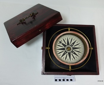
Functional object - Compass, mid-19th Century
... At around 7 pm, he discovered that the cargo had shifted during the storm and the heavy girders had damaged the hull, causing a leak. The pumps were inadequate to stem the fast-flowing leak, and water soon filled the hull during the next two hours. ...At around 7 pm, he discovered that the cargo had shifted during the storm and the heavy girders had damaged the hull, causing a leak. The pumps were inadequate to stem the fast-flowing leak, and water soon filled the hull during the next two hours. ...Captain Robilliard: James Arthur Robilliard was a sea captain and tentmaker, born on the 19th April 1843 at Saint Helier, Jersey. He trained there in his father's sail loft as a sailmaker. His first job as a sailor was in Liverpool, England, and in 1875, James Robilliard migrated to Australia as a mate on the "E.M. Young". James Robilliard and his family were amongst the early settlers who arrived along the Curdies River in the Heytesbury district of Western Victoria. In 1877, he became a Captain and would have used his compass from ship to ship. On 28th May 1877, in that same district, a small 3-masted schooner, the "Young Australian", was wrecked. This schooner had been built in 1864 at Jervis Bay, NSW. It had been on her way from Maryborough, Queensland, to Adelaide, under the command of Captain Whitfield, when it lost its mainmast in a heavy gale. It was beached at Curdies Inlet in Peterborough, Victoria. Captain Robilliard was placed in charge of the salvaging operation and recovered a good portion of the cargo. Not long after this incident, a Warrnambool shop owner, David Evans, found employment for James Robilliard with Evan Evans, who produced tents, sails, tarpaulins and similar goods; James already had the necessary skills for this work. Evan Evans was the same sailor rescued from the “Young Australian”. Soon after his rescue, Evan recalled he had a relative in Australia in a town called Warrnambool, and while walking in Timor Street, Warrnambool, he saw a sign over a shop that said “David Evans,” and once the two men met, Evan was warmly welcomed. David then helped his relative establish a tent and tarpaulin-making business there. Evan later transferred his successful business to a shop in Elizabeth St, Melbourne, under the name Evan Evans Pty. Ltd.) James Robilliard was a committed Christian and accredited Lay Preacher with the Methodist Church. He travelled around the local district leading the settlers in worship. On 14th November 1879, Captain Robilliard married Helen Beckett. Alfred and Selina Beckett and their family all attended the church at Brucknell, where Captain Robilliard preached. He was said to have been taken by their young daughter, Helen. James and Helen had ten children: James Arthur (Jnr), Henry William, Nellie Jessie, Alfred Albert, Rubena Nellie, De Jersy Norman, Clifford Beckett, Olive Ida, Frances Ridley Havergal and Nellie Elvie, all born in Victoria. In the 1880s, James Robilliard captained the cutter "Hannah Thompson" into Port Campbell, Victoria. This vessel was the first coastal trader to operate between Melbourne and Port Campbell. At one time, Captain Robilliard had to beach the "Hannah Thompson" for repairs. In 1923, the vessel was blown ashore in a gale and wrecked at Oberon Bay, at Wilson's Promontory. In 1889, the compass was saved by Captain James Arthur Robilliard from his sinking brigantine "Mary Campbell". This vessel was used to carry equipment for the Sydney Sugar Refinery's Mill in Southgate, NSW. The ship had been built in 1869 and traded for the next 20 years between Australian ports and rivers along the east coast, as well as regular ports in New Zealand. It was recognised by the Sydney Morning Herald as one of the best "carrying vessels in the timber trade". It had several owners over this time, the last one being Captain James A. Robilliard. On 29th April 1889, the "Mary Campbell", with Captain James A Robilliard as captain and owner, was on its way from Clarence River, NSW to Melbourne, Victoria with a cargo of railway girders for the Melbourne Harbour Trust. Captain Robilliard encountered a storm off Port Macquarie. He sailed the vessel south to about 40km east of Cape Hawke, near Tuncurry. At around 7 pm, he discovered that the cargo had shifted during the storm and the heavy girders had damaged the hull, causing a leak. The pumps were inadequate to stem the fast-flowing leak, and water soon filled the hull during the next two hours. Some of the crew began throwing the cargo overboard to lighten the vessel, hoping to keep it afloat until daylight. When the water reached over 2 meters in the hull, they realised their efforts were in vain. On the 30th April 1889, the crew left the vessel the ship was sinking fast, so they made for the shore. While still miles off Cape Hawke, all seven crew members, including the Captain, were rescued by the Government Tug "Rhea" and taken to Port Macquarie Hospital and later returned to Sydney in the vessel "Wellington". No cargo had been saved, and the consignment had been under-insured, only covered for half its value. The name of the last ship Captain Robilliard sailed is currently unknown; however, he sailed that ship from the port of Marlborough, Queensland, carting steel railway girders for the Geelong-to-Camperdown railway line. On this trip, the ship hit a storm, the cargo shifted, and the ship was wrecked along the NSW coast. After this, Captain Robilliard retired from the sea and began farming in Peterborough. In about 1897, verging on retirement, Capt. Robilliard superintended the Melbourne Sailors’ Home in Spencer Street, Melbourne, before being asked to leave this position in 1902 for trying to shut down a local hotel. On 6th May 1917, Captain James Arthur Robilliard J.P. died at Blackwood Park, in the Cobden district of Brucknell, the first Robilliard family homestead in Australia. He was buried in the Melbourne General Cemetery, Victoria. His wife Helen, passed away in 1947. This compass, once belonging to Captain James Arthur Robilliard, is of local and state historical significance for its use by the Captain with his vessel, the "Mary Campbell", a trading vessel that was bringing railway girders to the Melbourne Harbour Trust. He also used this compass on the "Hannah Thompson", listed on the Victorian Heritage Register and known as being the first coastal trader to operate between Melbourne and Port Campbell. The compass is also a very fine example of maritime navigational instruments manufactured and used in the mid-19th century. Marine compass, brass, in a wooden box with a separate, fitted lid. The compass card has sixteen points. The four principal points are marked: North with a star-shape, South with an “S”, East with an “E” and West with an “O” (French word OUEST). Each quadrant of the circle is numbered from 0 – 90 degrees. The card is floating in a liquid. The compass gimbal is attached to the sides of the box and to the front and back of the compass’ cylindrical brass frame. The mahogany coloured timber storage case is joined with brass nails. The centre of the lid has a folding decorative brass handle. The lid fits over the base and closes with a brass screw and hook on both front and back. Maker: Dubas Watchmaker Optician, Nantes, France, c 1860-1870. Compass came from the ship “Mary Campbell”, which sank off the NSW coast in 1889, near Forster. The compass, as well as the ship, belonged to Captain James Arthur Robilliard and was donated by his family. “DUBAS MANTES” stamped into the side of the gimbal. “DUBAS HORLOGER OPTICIEN. NANTES.” printed around the centre of the card. flagstaff hill, warrnambool, shipwrecked coast, flagstaff hill maritime museum, maritime museum, shipwreck coast, flagstaff hill maritime village, great ocean road, marine compass, navigation instrument 19th century, marine instruments, dubas mantes, captain james arthur robilliard, j.a. robilliard, helen beckett, ship young australian, ship young australia(n), ship hannah thompson, ship mary campbell, melbourne sailors home, david evans, evan evans, curdies inlet, brucknell church, curdies railway, great lakes museum, dubas horloger opticien. nantes -
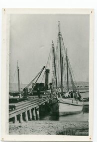 Orbost & District Historical Society
black and white photograph, before 1912
... This is a pictorial record of a time when the water highways were the only feasible transport mode in sending goods from Orbost and Marlo to Melbourne. storm-bird wangrabelle shipping transport- marlo on back - "M. ...This photo shows the Storm Bird at the end of the jetty and the Wangrabelle in the foreground. Both ships were well known traders. the Wangrabelle became beached and wrecked in 1916 and the Storm Bird became obsolete when the railway from Bairnsdale to Orbost arrived in 1916. (ref. Story of Gippsland Shipping - J.C. Bull) At the start of the river trade goods were shipped from Marlo to Melbourne but when the railway reached Bairnsdale this became unprofitable and the ships plied only between Marlo and Cunninghame. Eventually river transport became economically unviable. The Wongrabelle is still buried in the sands of the entrance of the Snowy River (albeit where the entrance used to be). It took from April 11th 1912 to August 12th 1912 for the loss of the Wongrabelle to be complete, the final entry in the Orbost Shipping Co. records reads:- "The Wongrabelle is completely covered in sand." (ref River, Road, Railway Newsletter O.D.H.S.) This is a pictorial record of a time when the water highways were the only feasible transport mode in sending goods from Orbost and Marlo to Melbourne.A black / white photograph of a ship, sails down, anchored at the Marlo jetty.on back - "M. Gilbert, Wangrabelle at Marlo"storm-bird wangrabelle shipping transport- marlo