Showing 24 items matching "stormwater"
-
 Eltham District Historical Society Inc
Book, Diamond Creek Basin Study. Part 1, A Compendium of Factors Relevant to Stormwater Flows, 1980
... Part 1, A Compendium of Factors Relevant to Stormwater Flows......stormwater...Part 1, A Compendium of Factors Relevant to Stormwater Flows Book Book Melbourne Metropolitan Board of Works ...Basin Studies are studies to evaluate water supply and demand and help ensure reliable water supplies by identifying strategies to address imbalances in water supply and demand.Spiral Bound. 157 leaves in various foliations (some folded) : illustrated. (some colour.), maps (some colour.)aerial photographs, allendale road, arthurs creek mine, arthurs creek road bridge, arthurs creek, bald spur look-out, bank protection, bolton steet, bridge street bridge, bridge street, bridges, challenger street, chute street, construction, coolaroo drive, culvert, deep creek, diamond creek basin, diamond creek region, diamond creek, diamond street bridge, drainage works, eltham lower park, eltham town park, eltham trestle bridge, eltham west drains, eltham, erosion, flood management, floods, footbridge, glen katherine estate, gold mining, gum glade, hurstbridge, kangaroo ground, kinglake escarpment, kinglake national park, latiners hat factory, main road bridge, main road, masons falls, melbourne metropolitan board of works, monash bridge, mount sugarloaf, nillumbik park, orchards, railway culvert, railway line, ramptons road, real estate advertisement, research creek, st helena east drain, st helena road, st helena, storm sewers, stormwater, sugarloaf-preston transfer main crossing, susan street, union mine, village pond, water flow, watkins street, wattletree road, weidlich road, wingrove park, yarra river, zig zag road, water supply, basin study -
 Eltham District Historical Society Inc
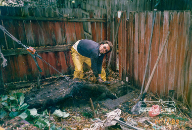
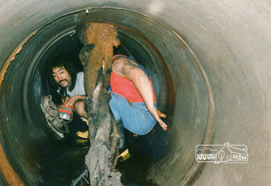
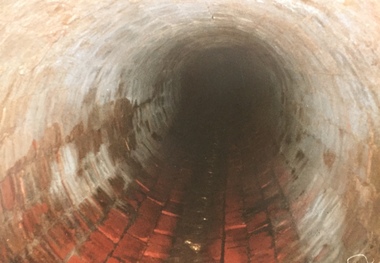
Photograph, Removing tree roots from stormwater drain, Starling Street, Montmorency, 14 December 1989, 14/12/1989
... Removing tree roots from stormwater drain, Starling Street, Montmorency, 14 December 1989...Eltham District Historical Society Inc 728 Main Rd Eltham melbourne Drainage works Eltham Shire Council Maintenance works Montmorency Starling Street Colour photograph Removing tree roots from stormwater drain, Starling Street, Montmorency, 14 December 1989 Photograph ...Colour photographdrainage works, eltham shire council, maintenance works, montmorency, starling street -
 Eltham District Historical Society Inc
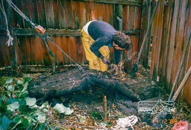
Photograph, Removing tree roots from stormwater drain, Starling Street, Montmorency, 14 December 1989, 14/12/1989
... Removing tree roots from stormwater drain, Starling Street, Montmorency, 14 December 1989...Eltham District Historical Society Inc 728 Main Rd Eltham melbourne drainage works eltham shire council maintenance works montmorency starling street Colour photograph Removing tree roots from stormwater drain, Starling Street, Montmorency, 14 December 1989 Photograph ...Colour photographdrainage works, eltham shire council, maintenance works, montmorency, starling street -
 Eltham District Historical Society Inc
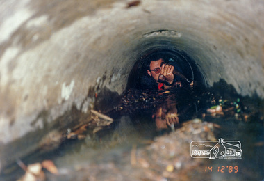
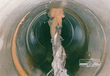
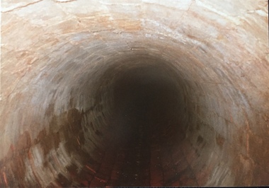
Photograph, Tree roots in main stormwater drain, Eltham Shire Council maintenance works, Lower Plenty, c.1989, 1989c
... Tree roots in main stormwater drain, Eltham Shire Council maintenance works, Lower Plenty, c.1989...Eltham District Historical Society Inc 728 Main Rd Eltham melbourne drainage works eltham shire council Infrastructure Lower Plenty Colour photograph Tree roots in main stormwater drain, Eltham Shire Council maintenance works, Lower Plenty, c.1989 Photograph ...Colour photographdrainage works, eltham shire council, infrastructure, lower plenty -
 Eltham District Historical Society Inc
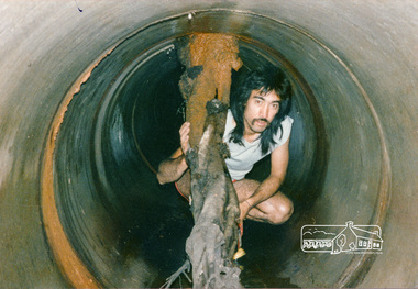
Photograph, Tree roots in main stormwater drain, Eltham Shire Council maintenance works, Lower Plenty, c.1989, 1989c
... Tree roots in main stormwater drain, Eltham Shire Council maintenance works, Lower Plenty, c.1989...Eltham District Historical Society Inc 728 Main Rd Eltham melbourne drainage works eltham shire council infrastructure lower plenty Colour photograph Tree roots in main stormwater drain, Eltham Shire Council maintenance works, Lower Plenty, c.1989 Photograph ...Colour photographdrainage works, eltham shire council, infrastructure, lower plenty -
 Eltham District Historical Society Inc
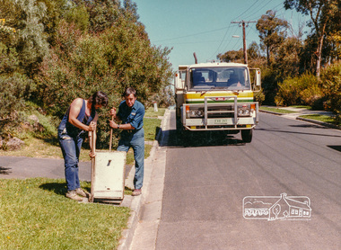
Photograph, Stormwater Maintenance, Eltham Shire Council, c. Oct 1987, 1987
... Stormwater Maintenance, Eltham Shire Council, c. ...Eltham District Historical Society Inc 728 Main Rd Eltham melbourne Date based on other similar display panels visible in images of the Shire of Eltham display at the Eltham Community Festival, 7 November 1987. display panel eltham festival infrastructure shire of eltham Maintenance works Eltham Shire Council Colour photograph Stormwater Maintenance, Eltham Shire Council, c. ...Date based on other similar display panels visible in images of the Shire of Eltham display at the Eltham Community Festival, 7 November 1987.Colour photographdisplay panel, eltham festival, infrastructure, shire of eltham, maintenance works, eltham shire council -
 Eltham District Historical Society Inc
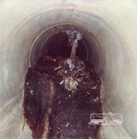
Photograph, Tree roots in stormwater drain, Shire of Eltham, c.1980, 1980c
... Tree roots in stormwater drain, Shire of Eltham, c.1980...Eltham District Historical Society Inc 728 Main Rd Eltham melbourne drainage works infrastructure polaroid Polaroid R Manufacturer's Batch No. 06031017011 (June 1980) Colour photograph Tree roots in stormwater drain, Shire of Eltham, c.1980 Photograph ...Colour photographPolaroid R Manufacturer's Batch No. 06031017011 (June 1980)drainage works, infrastructure, polaroid -
 Moorabbin Air Museum
Plan (item) - CAC Commonwealth Aircraft Corporation Stormwater Drains, Commonwealth Aircraft Corporation Pty Limited Stormwater Drain Layout
... Commonwealth Aircraft Corporation Pty Limited Stormwater Drain Layout...Moorabbin Air Museum Moorabbin Airport 12 First Street Moorabbin melbourne Commonwealth Aircraft Company Commonwealth Aircraft Corporation Pty Limited Stormwater Drain Layout Plan CAC Commonwealth Aircraft Corporation Stormwater Drains ...Commonwealth Aircraft Company -
Whitehorse Historical Society Inc.
Article, Leak plugged in time, 2010
... Article on a leak of harmful coolant from Gainsborough Hardware Industries into a stormwater drain and the Environment Protection Authority's order to the company to remedy the problem....Article on a leak of harmful coolant from Gainsborough Hardware Industries into a stormwater drain and the Environment Protection Authority's order to the company to remedy the problem. ...Article on a leak of harmful coolant from Gainsborough Hardware Industries into a stormwater drain and the Environment Protection Authority's order to the company to remedy the problem.Article on a leak of harmful coolant from Gainsborough Hardware Industries into a stormwater drain and the Environment Protection Authority's order to the company to remedy the problem.Article on a leak of harmful coolant from Gainsborough Hardware Industries into a stormwater drain and the Environment Protection Authority's order to the company to remedy the problem.gainsborough hardware industries ltd, blackburn creek -
 Greensborough Historical Society
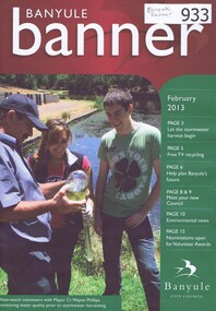
Magazine, Banyule City Council, Banyule Banner February 2013, 2013_02
... This edition includes information on Stormwater harvest; TV recycling; Banyule's future and the new Councillors....This edition includes information on Stormwater harvest; TV recycling; Banyule's future and the new Councillors. ...The Banyule Banner is published quarterly by Banyule City Council to advertise upcoming events in the City of Banyule and to report on past events. This edition includes information on Stormwater harvest; TV recycling; Banyule's future and the new Councillors.A record of events within the City of Banyule.20 pages (approx.), colour illustrations.banyule city council -
 Greensborough Historical Society
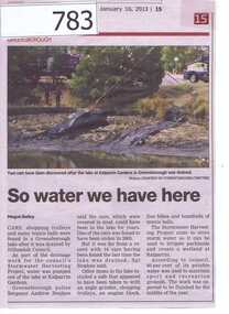
Newspaper clipping, Diamond Valley Leader, So water we have here, 16/01/2013
... This article is about the recovery of stolen vehicles from the Kalparrin Lake after it was drained as a part of the Stormwater harvesting project. Other items recovered included a safe, shopping trolleys, an engine block, five bicycles and hundreds of tennis balls....The Stormwater will be used to water parklands and create a wetland at Kalparrin. kalparrin reserve stormwater harvesting stolen cars A small newspaper article featuring a colour photograph. ...This article is about the recovery of stolen vehicles from the Kalparrin Lake after it was drained as a part of the Stormwater harvesting project. Other items recovered included a safe, shopping trolleys, an engine block, five bicycles and hundreds of tennis balls.The Stormwater will be used to water parklands and create a wetland at Kalparrin.A small newspaper article featuring a colour photograph.kalparrin reserve, stormwater harvesting, stolen cars -
 Eltham District Historical Society Inc
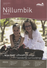
Journal - Newsletter, Nillumbik Shire Council, Nillumbik News, March 2014
... Quarterly community newsletter produced by the Shire of Nillumbik featuring feature stories, council plans, Mayor's report, Australia Day awards, community projects, transformation of former high school land in Hurstbridge, welands and stormwater harvesting system, arts and culture activities, Nillumbik youth services and community calandar and list of councilors....Quarterly community newsletter produced by the Shire of Nillumbik featuring feature stories, council plans, Mayor's report, Australia Day awards, community projects, transformation of former high school land in Hurstbridge, welands and stormwater harvesting system, arts and culture activities, Nillumbik youth services and community calandar and list of councilors. ...Quarterly community newsletter produced by the Shire of Nillumbik featuring feature stories, council plans, Mayor's report, Australia Day awards, community projects, transformation of former high school land in Hurstbridge, welands and stormwater harvesting system, arts and culture activities, Nillumbik youth services and community calandar and list of councilors.council newsletters, nillumbik news, nillumbik shire council, edendale farm, amanda gibson, joy ferguson, diamond creek men's shed, australia day awards, jenny kennedy, diamond creek parkrun, hurstbridge, st andrews community centre, eltham copper butterfly, volunteers -
 Bendigo Historical Society Inc.
Document - RESEARCH NOTES: ONE TREE HILL, STORMWATER CHANNEL, ANTHONY TROILLOPE, HORSE TRAMWAY TO GOLDEN SQUARE
... Mentioned are: - Some Notes Concerning The Eaglehawk Logs, Damaging the Stormwater Channel, where some Chinese were digging away the Creek, the cutting down of the giant gum tree which gave One Tree Hill its name, How Anthony Trollope saw Bendigo in the 1870's, A Proposed Horse Tramway to Golden Square, Society’s' Trip to Bridgewater Flour Mill, A talk on a trip to Malaya by Mr D Hester, Society News and Happenings, Old Bendigonians and Safety Cages,...Mentioned are: - Some Notes Concerning The Eaglehawk Logs, Damaging the Stormwater Channel, where some Chinese were digging away the Creek, the cutting down of the giant gum tree which gave One Tree Hill its name, How Anthony Trollope saw Bendigo in the 1870's, A Proposed Horse Tramway to Golden Square, Society’s' Trip to Bridgewater Flour Mill, A talk on a trip to Malaya by Mr D Hester, Society News and Happenings, Old Bendigonians and Safety Cages, Document RESEARCH NOTES: ONE TREE HILL, STORMWATER CHANNEL, ANTHONY TROILLOPE, HORSE TRAMWAY TO GOLDEN SQUARE ...Typed and handwritten notes. Mentioned are: - Some Notes Concerning The Eaglehawk Logs, Damaging the Stormwater Channel, where some Chinese were digging away the Creek, the cutting down of the giant gum tree which gave One Tree Hill its name, How Anthony Trollope saw Bendigo in the 1870's, A Proposed Horse Tramway to Golden Square, Society’s' Trip to Bridgewater Flour Mill, A talk on a trip to Malaya by Mr D Hester, Society News and Happenings, Old Bendigonians and Safety Cages,document, various notes, eaglehawk logs, bendigo advertiser 19/10/1858, damaging the stormwater channel, bendigo advertiser 11/8/1872, harneys bridge, gas works, constable rogers, constable james bradley, joch, john o'c hattam, one tree hill, ryan, trollope's fabulous bendigo, anthony trollope, 'trollope’s australia', nelson press, alex h stone, bendigo advertiser 5/7/1897, mr peter ellis, cr hoskins, horse tramway, historical society, water wheel flour mill, june parry, mr pat wodetzki, mr leo wodetzki, neil murray, mr k hester, mr wes harry, mr i hendry, mr henry jackson, mr connelly, mr irons, mr harney, dr smith, dr hoyle, rev dr bachaus, rev dr nish, rev joseph dare, hon angus mackay, mr haverfield, mr j k robshaw, w p neal, mr george lansell, hon j h abbott, m l c, mr j casey, dr james boyd, dr atkinson, dr easie, mr t h henderson, old beehive, francis brothers, mr john crowley, mr jacob cohn, art gallery, mr hugh mcdevitt, mr alexander bayne, mr f sciallero, camp reserve, hon w i winter-irvine, mr george avery fletcher, great central goldfield of victoria, safety cages, bendigo advertiser, j h seymour, mr horwood, new chum and victoria tribute company, james watson, seymour's patent safety cage, londerry tribute, national show sandhurst, h banfield, mr a llewllyn, 'dear old bendigo', thomas bracken, mr william heffernan, mr edward (ned) ryan, mr samuel bastard, mr charles bird, mcpherson and co, fern hill club, mr george tolhurst, tolhurst brothers, union bank, mr lawrence ryan, mr shadrack jones, charley armstrong, armstrong brothers, mr abraham solomen, mr bladiere mr r t wheeler -
 Kew Historical Society Inc
Photograph - Kew Main Drain, 1984
... 'Kew, Kew East, Balwyn & Balwyn North are located approximately 7km north east of Melbourne. Four main stormwater drains service the area flowing from south to north. ...Kew Historical Society Inc Kew Court House 188 High Street Kew melbourne 'Kew, Kew East, Balwyn & Balwyn North are located approximately 7km north east of Melbourne. Four main stormwater drains service the area flowing from south to north. ...'Kew, Kew East, Balwyn & Balwyn North are located approximately 7km north east of Melbourne. Four main stormwater drains service the area flowing from south to north. Three of the drains: Deepdene Drain; Balwyn Drain & Glass Creek converge in Kew East just west of Burke Road at Kew High School before discharging into the Yarra River. The fourth drain, Kew Main Drain connects directly with the Yarra River to the West of Glass Creek.' The Kew Main Drain is a barrel drain that was created in the 1930s, and follows the route of the former Connor's Creek from the vicinity of Genazzano FCJ College to the Yarra River in East KewImportant and verifiable evidence of the construction methods used by the Melbourne & Metropolitan Board of Works in building the Kew Main Drain, before its reconstruction in c.1985.Original print colour positive photograph of the Kew Main Drain, provided on 14/12.84 to the Chief Engineer of the City of Kew, Ian Poulter, by the Supervising Engineer (Works), Southern and Eastern Drainage, Melbourne & Metropolitan Board of Works. The record includes an image of the reverse as well as the donation document from the MMBW."A84/1855-9 / 750mm council drain looking D/S [down stream] and across Parkhill Road. To be replaced with 1200 mm R.C.P. [reinforced concrete pipe] as part of MMBW Kew Main Drain reconstruction works"kew main drain, stormwater drains -- kew (vic.), connor's creek -- kew (vic.) -
 Kew Historical Society Inc
Photograph - Kew Main Drain, 1984
... 'Kew, Kew East, Balwyn & Balwyn North are located approximately 7km north east of Melbourne. Four main stormwater drains service the area flowing from south to north. ...Kew Historical Society Inc Kew Court House 188 High Street Kew melbourne 'Kew, Kew East, Balwyn & Balwyn North are located approximately 7km north east of Melbourne. Four main stormwater drains service the area flowing from south to north. ...'Kew, Kew East, Balwyn & Balwyn North are located approximately 7km north east of Melbourne. Four main stormwater drains service the area flowing from south to north. Three of the drains: Deepdene Drain; Balwyn Drain & Glass Creek converge in Kew East just west of Burke Road at Kew High School before discharging into the Yarra River. The fourth drain, Kew Main Drain connects directly with the Yarra River to the West of Glass Creek.' The Kew Main Drain is a barrel drain that was created in the 1930s, and follows the route of the former Connor's Creek from the vicinity of Genazzano FCJ College to the Yarra River in East KewImportant and verifiable evidence of the construction methods used by the Melbourne & Metropolitan Board of Works in building the Kew Main Drain, before its reconstruction in c.1985.Original print colour positive photograph of the Kew Main Drain, provided on 14/12.84 to the Chief Engineer of the City of Kew, Ian Poulter, by the Supervising Engineer (Works), Southern and Eastern Drainage, Melbourne & Metropolitan Board of Works. The record includes an image of the reverse as well as the donation document from the MMBW."A84/1855-10 / 750mm council drain looking U/S [up stream] from Parkhill Road, Kew."kew main drain, stormwater drains -- kew (vic.), connor's creek -- kew (vic.) -
 Eltham District Historical Society Inc
Journal - Newsletter, Nillumbik Shire Council, Nillumbik News, October 2000
... October 2000 articles include: Safer roads for the Shire Eltham Festival program announced Commercial Place design released 2000-2003 Council Plan Released National Reconciliation Framework Living and Learning Centres More Playgrounds Susan St Pavilion completed Study to plan for BMX/skate track Wattle Glen Township Strategy Community Weed Control Program Count Koala Day Environment Centre proposed for Edendale Farm Open Space Strategy findings Neighbourhood Character Study and Residential Design Guidelines Friends groups Clean Drains – Living Creeks, National Water Week Nillumbik Shire Council Cultural Plan 2000-2005 adopted 2001 Alan Marshall Short Story Award Artists’ Open Studios program Kangaroo Ground Tower Advisory Committee Environment leaders at Eltham North primary Dollars saved by regular road maintenance Regional Road upgrades Rural roads grading program Stormwater Management Plan Locality boundary update ...October 2000 articles include: Safer roads for the Shire Eltham Festival program announced Commercial Place design released 2000-2003 Council Plan Released National Reconciliation Framework Living and Learning Centres More Playgrounds Susan St Pavilion completed Study to plan for BMX/skate track Wattle Glen Township Strategy Community Weed Control Program Count Koala Day Environment Centre proposed for Edendale Farm Open Space Strategy findings Neighbourhood Character Study and Residential Design Guidelines Friends groups Clean Drains – Living Creeks, National Water Week Nillumbik Shire Council Cultural Plan 2000-2005 adopted 2001 Alan Marshall Short Story Award Artists’ Open Studios program Kangaroo Ground Tower Advisory Committee Environment leaders at Eltham North primary Dollars saved by regular road maintenance Regional Road upgrades Rural roads grading program Stormwater Management Plan Locality boundary update Council Newsletters Nillumbik News Nillumbik Shire Council Council Plan 2000–2003 Municipal Road Safety Strategy Infrastructure services Stormwater Management Plan Locality boundary review Rates Sustainable agriculture rebate Capital works program road maintenance Better Roads Victorian program eltham - yarra glen road Warrandyte - Kangaroo Ground Road Rural roads grading program Commercial Place Public space public infrastructrue meals on wheels Eltham Living and Learning Centre Living and Learning Centre adult community education volunteer programs Australia Day Awards community groups environmental protection sustainability Community weed control landcare koalas Drainage works waterway protection indigenous grass environmental education Open Space public parkland playgrounds bike trail Adventure Playground community reserves Kangaroo Ground Tower reserve Cultural plan Eltham festival Artists Open Studios cultural tourism Alan Marshall Short Story Award Montsalvat community arts program garden walks Eltham Fun Run community market mudbrick tours CERES Environmental Education Centre Nillumbik Tourism Association Food and Wine trail Yarra Valley Tourism campaign road safety Adrian Cully Alan Marshall Andrew Port Anne Connor Catherine Dale Chris Wallace-Crabbe Claire Harris David Scott David Yencken Dean Stewart Deb Ganderton Debra Wilkinson Denis Ward drew gregory Daryl Taylor Fiona Austin Frank Butters Frank Nolan Gavin Jordan Glen Jameson Grace Mitchell Greg Scott Harry Gilham Helen Ash Jane Annois jane viola Jan Kelly Jenneke Korteweg Jenni Mitchell Jessica Davison Jill Forrest john hewish Jules Burns Julius Peiker kay steventon Kayte Nunn Lesley Shuttleworth leslie Avril Louise Heathcote Marg Jeffery Margaret Jennings Martin Wright Mathew Hodsnesse Maurice Stabb Megan McCarthy Mervyn Hannan Michael Jansz michael skewes Mick Woiwod nel ten wolde Nicholas Pelling Ona Henderson Peter Burn Piers Bateman reg cox Reg Evans Robert Boyle Robert Hay Robert Theobald shan shnookal Sigmund Jorgensen Stuart Menzies Steven White Vonnie Frazer Eltham District Historical Society Council for Aboriginal Reconciliation Eltham North Primary School Wattle Glen Primary School Eltham Arts Council Churinga Arts Harvey World Travel (Eltham) Eltham Little Book Shop Do Lunch Cafe Volumes Cafe Grovedale Cottage Lovegrove Winery Cottles Bridge Yarrambat Golf Club Eltham Football Club Eltham Rugby Football Club Lower Eltham Cricket Club Susan Street Oval Syd Tunn Jack Rasterhoff A4. monotone print, double stapled, 4 pages Nillumbik News Journal Newsletter Nillumbik Shire Council ...The newsletter outlines local government initiatives, community events, environmental programs, infrastructure projects, and cultural activities occurring in the Nillumbik Shire around October–November 2000. It highlights council plans, community participation opportunities, and local developments aimed at improving quality of life in the region. October 2000 articles include: Safer roads for the Shire Eltham Festival program announced Commercial Place design released 2000-2003 Council Plan Released National Reconciliation Framework Living and Learning Centres More Playgrounds Susan St Pavilion completed Study to plan for BMX/skate track Wattle Glen Township Strategy Community Weed Control Program Count Koala Day Environment Centre proposed for Edendale Farm Open Space Strategy findings Neighbourhood Character Study and Residential Design Guidelines Friends groups Clean Drains – Living Creeks, National Water Week Nillumbik Shire Council Cultural Plan 2000-2005 adopted 2001 Alan Marshall Short Story Award Artists’ Open Studios program Kangaroo Ground Tower Advisory Committee Environment leaders at Eltham North primary Dollars saved by regular road maintenance Regional Road upgrades Rural roads grading program Stormwater Management Plan Locality boundary update council newsletters, nillumbik news, nillumbik shire council, council plan 2000–2003, municipal road safety strategy, infrastructure services, stormwater management plan, locality boundary review, rates, sustainable agriculture rebate, capital works program, road maintenance, better roads victorian program, eltham - yarra glen road, warrandyte - kangaroo ground road, rural roads grading program, commercial place, public space, public infrastructrue, meals on wheels, eltham living and learning centre, living and learning centre, adult community education, volunteer programs, australia day awards, community groups, environmental protection, sustainability, community weed control, landcare, koalas, drainage works, waterway protection, indigenous grass, environmental education, open space, public parkland, playgrounds, bike trail, adventure playground, community reserves, kangaroo ground tower reserve, cultural plan, eltham festival, artists open studios, cultural tourism, alan marshall short story award, montsalvat, community arts program, garden walks, eltham fun run, community market, mudbrick tours, ceres environmental education centre, nillumbik tourism association, food and wine trail, yarra valley tourism campaign, road safety, adrian cully, alan marshall, andrew port, anne connor, catherine dale, chris wallace-crabbe, claire harris, david scott, david yencken, dean stewart, deb ganderton, debra wilkinson, denis ward, drew gregory, daryl taylor, fiona austin, frank butters, frank nolan, gavin jordan, glen jameson, grace mitchell, greg scott, harry gilham, helen ash, jane annois, jane viola, jan kelly, jenneke korteweg, jenni mitchell, jessica davison, jill forrest, john hewish, jules burns, julius peiker, kay steventon, kayte nunn, lesley shuttleworth, leslie avril, louise heathcote, marg jeffery, margaret jennings, martin wright, mathew hodsnesse, maurice stabb, megan mccarthy, mervyn hannan, michael jansz, michael skewes, mick woiwod, nel ten wolde, nicholas pelling, ona henderson, peter burn, piers bateman, reg cox, reg evans, robert boyle, robert hay, robert theobald, shan shnookal, sigmund jorgensen, stuart menzies, steven white, vonnie frazer, eltham district historical society, council for aboriginal reconciliation, eltham north primary school, wattle glen primary school, eltham arts council, churinga arts, harvey world travel (eltham), eltham little book shop, do lunch cafe, volumes cafe, grovedale cottage, lovegrove winery cottles bridge, yarrambat golf club, eltham football club, eltham rugby football club, lower eltham cricket club, susan street oval, syd tunn, jack rasterhoff -
 Eltham District Historical Society Inc
Journal - Newsletter, Nillumbik Shire Council, Nillumbik News, October 2000
... October 2000 articles include: Safer roads for the Shire Eltham Festival program announced Commercial Place design released 2000-2003 Council Plan Released National Reconciliation Framework Living and Learning Centres More Playgrounds Susan St Pavilion completed Study to plan for BMX/skate track Wattle Glen Township Strategy Community Weed Control Program Count Koala Day Environment Centre proposed for Edendale Farm Open Space Strategy findings Neighbourhood Character Study and Residential Design Guidelines Friends groups Clean Drains – Living Creeks, National Water Week Nillumbik Shire Council Cultural Plan 2000-2005 adopted 2001 Alan Marshall Short Story Award Artists’ Open Studios program Kangaroo Ground Tower Advisory Committee Environment leaders at Eltham North primary Dollars saved by regular road maintenance Regional Road upgrades Rural roads grading program Stormwater Management Plan Locality boundary update ...October 2000 articles include: Safer roads for the Shire Eltham Festival program announced Commercial Place design released 2000-2003 Council Plan Released National Reconciliation Framework Living and Learning Centres More Playgrounds Susan St Pavilion completed Study to plan for BMX/skate track Wattle Glen Township Strategy Community Weed Control Program Count Koala Day Environment Centre proposed for Edendale Farm Open Space Strategy findings Neighbourhood Character Study and Residential Design Guidelines Friends groups Clean Drains – Living Creeks, National Water Week Nillumbik Shire Council Cultural Plan 2000-2005 adopted 2001 Alan Marshall Short Story Award Artists’ Open Studios program Kangaroo Ground Tower Advisory Committee Environment leaders at Eltham North primary Dollars saved by regular road maintenance Regional Road upgrades Rural roads grading program Stormwater Management Plan Locality boundary update Council Newsletters Nillumbik News Nillumbik Shire Council Council Plan 2000–2003 Municipal Road Safety Strategy Infrastructure services Stormwater Management Plan Locality boundary review Rates Sustainable agriculture rebate Capital works program road maintenance Better Roads Victorian program eltham - yarra glen road Warrandyte - Kangaroo Ground Road Rural roads grading program Commercial Place Public space public infrastructrue meals on wheels Eltham Living and Learning Centre Living and Learning Centre adult community education volunteer programs Australia Day Awards community groups environmental protection sustainability Community weed control landcare koalas Drainage works waterway protection indigenous grass environmental education Open Space public parkland playgrounds bike trail Adventure Playground community reserves Kangaroo Ground Tower reserve Cultural plan Eltham festival Artists Open Studios cultural tourism Alan Marshall Short Story Award Montsalvat community arts program garden walks Eltham Fun Run community market mudbrick tours CERES Environmental Education Centre Nillumbik Tourism Association Food and Wine trail Yarra Valley Tourism campaign road safety Adrian Cully Alan Marshall Andrew Port Anne Connor Catherine Dale Chris Wallace-Crabbe Claire Harris David Scott David Yencken Dean Stewart Deb Ganderton Debra Wilkinson Denis Ward drew gregory Daryl Taylor Fiona Austin Frank Butters Frank Nolan Gavin Jordan Glen Jameson Grace Mitchell Greg Scott Harry Gilham Helen Ash Jane Annois jane viola Jan Kelly Jenneke Korteweg Jenni Mitchell Jessica Davison Jill Forrest john hewish Jules Burns Julius Peiker kay steventon Kayte Nunn Lesley Shuttleworth leslie Avril Louise Heathcote Marg Jeffery Margaret Jennings Martin Wright Mathew Hodsnesse Maurice Stabb Megan McCarthy Mervyn Hannan Michael Jansz michael skewes Mick Woiwod nel ten wolde Nicholas Pelling Ona Henderson Peter Burn Piers Bateman reg cox Reg Evans Robert Boyle Robert Hay Robert Theobald shan shnookal Sigmund Jorgensen Stuart Menzies Steven White Vonnie Frazer Eltham District Historical Society Council for Aboriginal Reconciliation Eltham North Primary School Wattle Glen Primary School Eltham Arts Council Churinga Arts Harvey World Travel (Eltham) Eltham Little Book Shop Do Lunch Cafe Volumes Cafe Grovedale Cottage Lovegrove Winery Cottles Bridge Yarrambat Golf Club Eltham Football Club Eltham Rugby Football Club Lower Eltham Cricket Club Susan Street Oval Syd Tunn Jack Rasterhoff A4. two colour print (orange/blue), double stapled, 16 pages Nillumbik News Journal Newsletter Nillumbik Shire Council ...The newsletter outlines local government initiatives, community events, environmental programs, infrastructure projects, and cultural activities occurring in the Nillumbik Shire around October–November 2000. It highlights council plans, community participation opportunities, and local developments aimed at improving quality of life in the region. October 2000 articles include: Safer roads for the Shire Eltham Festival program announced Commercial Place design released 2000-2003 Council Plan Released National Reconciliation Framework Living and Learning Centres More Playgrounds Susan St Pavilion completed Study to plan for BMX/skate track Wattle Glen Township Strategy Community Weed Control Program Count Koala Day Environment Centre proposed for Edendale Farm Open Space Strategy findings Neighbourhood Character Study and Residential Design Guidelines Friends groups Clean Drains – Living Creeks, National Water Week Nillumbik Shire Council Cultural Plan 2000-2005 adopted 2001 Alan Marshall Short Story Award Artists’ Open Studios program Kangaroo Ground Tower Advisory Committee Environment leaders at Eltham North primary Dollars saved by regular road maintenance Regional Road upgrades Rural roads grading program Stormwater Management Plan Locality boundary update council newsletters, nillumbik news, nillumbik shire council, council plan 2000–2003, municipal road safety strategy, infrastructure services, stormwater management plan, locality boundary review, rates, sustainable agriculture rebate, capital works program, road maintenance, better roads victorian program, eltham - yarra glen road, warrandyte - kangaroo ground road, rural roads grading program, commercial place, public space, public infrastructrue, meals on wheels, eltham living and learning centre, living and learning centre, adult community education, volunteer programs, australia day awards, community groups, environmental protection, sustainability, community weed control, landcare, koalas, drainage works, waterway protection, indigenous grass, environmental education, open space, public parkland, playgrounds, bike trail, adventure playground, community reserves, kangaroo ground tower reserve, cultural plan, eltham festival, artists open studios, cultural tourism, alan marshall short story award, montsalvat, community arts program, garden walks, eltham fun run, community market, mudbrick tours, ceres environmental education centre, nillumbik tourism association, food and wine trail, yarra valley tourism campaign, road safety, adrian cully, alan marshall, andrew port, anne connor, catherine dale, chris wallace-crabbe, claire harris, david scott, david yencken, dean stewart, deb ganderton, debra wilkinson, denis ward, drew gregory, daryl taylor, fiona austin, frank butters, frank nolan, gavin jordan, glen jameson, grace mitchell, greg scott, harry gilham, helen ash, jane annois, jane viola, jan kelly, jenneke korteweg, jenni mitchell, jessica davison, jill forrest, john hewish, jules burns, julius peiker, kay steventon, kayte nunn, lesley shuttleworth, leslie avril, louise heathcote, marg jeffery, margaret jennings, martin wright, mathew hodsnesse, maurice stabb, megan mccarthy, mervyn hannan, michael jansz, michael skewes, mick woiwod, nel ten wolde, nicholas pelling, ona henderson, peter burn, piers bateman, reg cox, reg evans, robert boyle, robert hay, robert theobald, shan shnookal, sigmund jorgensen, stuart menzies, steven white, vonnie frazer, eltham district historical society, council for aboriginal reconciliation, eltham north primary school, wattle glen primary school, eltham arts council, churinga arts, harvey world travel (eltham), eltham little book shop, do lunch cafe, volumes cafe, grovedale cottage, lovegrove winery cottles bridge, yarrambat golf club, eltham football club, eltham rugby football club, lower eltham cricket club, susan street oval, syd tunn, jack rasterhoff -
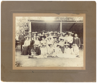 Tarnagulla History Archive
Photograph of Tarnagulla Tennis Club members, Tarnagulla Tennis Club members, c. 1900
... This excellent photograph of the Tarnagulla Tennis Club members, c.1900, is oriented east to west. The main stormwater channel is at the rear of the shelter. ...This excellent photograph of the Tarnagulla Tennis Club members, c.1900, is oriented east to west. The main stormwater channel is at the rear of the shelter. ...Murray Comrie Collection.Members of the Tarnagulla Tennis Club, posed as a group in front of the Club Shelter (now demolished). Some names of subjects handwritten on reverse. Also handwritten on reverse: 'L.Williams' and 'Leo Fitzgerald, "Clyde House", 182 Collins St, Melbourne'. This excellent photograph of the Tarnagulla Tennis Club members, c.1900, is oriented east to west. The main stormwater channel is at the rear of the shelter. Boy on the right at the back: Fred Radnell. Back row, from the left: unknown, F.Walker (chemist), unknown, unknown, William Harper (schoolmaster), Alice Joyce, Mary Comrie, unknown, Daniel Duggan, unknown, unknown, unknown, Ruth Langan, Thomas Page (printer). Middle row, from the left: Maud Renshaw, unknown, Emily Renshaw, Eliza Renshaw, Ruth Bool, Mrs Tom Leonard (Emma Davies) with child Viva Hale, Jessie Joyce, Front row, from the left, unknown, Emily Joyce, Annie Ison, Elsie Comrie, Florrie Bool, unknown. tarnagulla, sport, tennis, bool, dyer, page, renshaw, leonard, ison, nicholls -
 Melbourne Tram Museum
Drawing, Melbourne & Metropolitan Tramways Board (MMTB), Aerial photographs Bundoora Tram Extensions, Plenty Road – MMTB Drawings – 12/1979, Bundoora Extension – Metropolitan Transit Authority – 2/1983, John-Connell – Mott Hay and Anderson – Preliminary drawings for the Latrobe Modal Interchange – August 1984, 1979 to 1984
... Has written on rear at right hand end “Bundoora Tram Extension – Official MMTB Plans” 760H x 1190W Plenty Road – MMTB Drawings – 12/1979 P15123 Tyler St to Walsal Avenue P15124 Walsal Ave t McColl St P15125 McColl St to Dorrington Avenue Bundoora Extension – Metropolitan Transit Authority – 2/1983 P15400 Dorrington Avenue to Barwon Avenue P15401 Barwon Avenue to Nicholson Ave P15402 Nicholson St to Barling Park P15403 Barling Park to Darebin Creek P15404 Darebin Creek to Scott Grove P15405 Scott Grove to Clunes Street P15406 Clunes St to Cash St P15408 Cash St to Bundoora Park P15409 Bundoora Park to Larundel Hospital P15410 At Larundel Hospital P15411 Larundel Hospital to Marne Court P15412 Marne Court to Cherrywood Court P15413 Cherrywood Court to Morwell Ave P15414 Morwell Ave to Grimshaw St P15415 Grimshaw St to Nickson Street P15416 Nickson St to McLeans Road John-Connell – Mott Hay and Anderson – Preliminary drawings for the Latrobe Modal Interchange – August 1984. 8094-A-20 Set Out Plan and Paving Details 8094-A-21 Elevations 8094-A-22 Sections 8094-A-23 Roof Plan and Stormwater Layout 8094-A-24 Canopy Details 8094-A-25 Toilet Block and Waiting Room 8094-A-28 Miscellaneous Details...Has written on rear at right hand end “Bundoora Tram Extension – Official MMTB Plans” 760H x 1190W Plenty Road – MMTB Drawings – 12/1979 P15123 Tyler St to Walsal Avenue P15124 Walsal Ave t McColl St P15125 McColl St to Dorrington Avenue Bundoora Extension – Metropolitan Transit Authority – 2/1983 P15400 Dorrington Avenue to Barwon Avenue P15401 Barwon Avenue to Nicholson Ave P15402 Nicholson St to Barling Park P15403 Barling Park to Darebin Creek P15404 Darebin Creek to Scott Grove P15405 Scott Grove to Clunes Street P15406 Clunes St to Cash St P15408 Cash St to Bundoora Park P15409 Bundoora Park to Larundel Hospital P15410 At Larundel Hospital P15411 Larundel Hospital to Marne Court P15412 Marne Court to Cherrywood Court P15413 Cherrywood Court to Morwell Ave P15414 Morwell Ave to Grimshaw St P15415 Grimshaw St to Nickson Street P15416 Nickson St to McLeans Road John-Connell – Mott Hay and Anderson – Preliminary drawings for the Latrobe Modal Interchange – August 1984. 8094-A-20 Set Out Plan and Paving Details 8094-A-21 Elevations 8094-A-22 Sections 8094-A-23 Roof Plan and Stormwater Layout 8094-A-24 Canopy Details 8094-A-25 Toilet Block and Waiting Room 8094-A-28 Miscellaneous Details Aerial photographs Bundoora Tram Extensions, Plenty Road – MMTB Drawings – 12/1979, Bundoora Extension – Metropolitan Transit Authority – 2/1983, John-Connell – Mott Hay and Anderson – Preliminary drawings for the Latrobe Modal Interchange – August 1984. ...Set of drawings for the MMTB Plenty Road extension in 1979, MTA extension to Bundoora in 1983 and the Latrobe Uni Modal Interchange - 1984. Large print – Aerial photographs Bundoora Tram Extensions Stage 2 – Albert St to Kingsbury Drive Stage 3 – Kingsbury Drive to Settlement Road Has been rolled, left hand edge damaged, right hand edge torn Compiled by the ROW Division – 2/1981. Has written on rear at right hand end “Bundoora Tram Extension – Official MMTB Plans” 760H x 1190W Plenty Road – MMTB Drawings – 12/1979 P15123 Tyler St to Walsal Avenue P15124 Walsal Ave t McColl St P15125 McColl St to Dorrington Avenue Bundoora Extension – Metropolitan Transit Authority – 2/1983 P15400 Dorrington Avenue to Barwon Avenue P15401 Barwon Avenue to Nicholson Ave P15402 Nicholson St to Barling Park P15403 Barling Park to Darebin Creek P15404 Darebin Creek to Scott Grove P15405 Scott Grove to Clunes Street P15406 Clunes St to Cash St P15408 Cash St to Bundoora Park P15409 Bundoora Park to Larundel Hospital P15410 At Larundel Hospital P15411 Larundel Hospital to Marne Court P15412 Marne Court to Cherrywood Court P15413 Cherrywood Court to Morwell Ave P15414 Morwell Ave to Grimshaw St P15415 Grimshaw St to Nickson Street P15416 Nickson St to McLeans Road John-Connell – Mott Hay and Anderson – Preliminary drawings for the Latrobe Modal Interchange – August 1984. 8094-A-20 Set Out Plan and Paving Details 8094-A-21 Elevations 8094-A-22 Sections 8094-A-23 Roof Plan and Stormwater Layout 8094-A-24 Canopy Details 8094-A-25 Toilet Block and Waiting Room 8094-A-28 Miscellaneous DetailsOn rear of aerial photograph sheet - at right hand end “Bundoora Tram Extension – Official MMTB Plans” in felt pen.trams, tramways, plenty rd, bundoora, latrobe university, mmtb, construction, mta -
 Eltham District Historical Society Inc
Photograph - Digital Photograph, Alan King, Diamond Creek, Barak Bushlands, Eltham, 2008
... The beautiful wetland treats most of the estate’s stormwater runoff. Storm water is filtered through plants in the wetland ponds then is released slowly into the billabong, before flowing into the Diamond Creek. ...The beautiful wetland treats most of the estate’s stormwater runoff. Storm water is filtered through plants in the wetland ponds then is released slowly into the billabong, before flowing into the Diamond Creek. ...A habitat corridor and it strengthens the community. Published: Nillumbik Now and Then / Marguerite Marshall 2008; photographs Alan King with Marguerite Marshall.; p185 Barak Bushlands lie west of the Diamond Creek on the corner of Falkiner Street and busy, noisy Main Road. They form part of an important habitat corridor linking the Yarra River to the Kinglake National Park.1 Manna Gums, tawny frogmouths and platypuses are some of the indigenous plants and animals that have made their home there. The bushlands are the result of more than nine years of hard work by the local community with the Nillumbik Council, to transform a degraded flood plain into this refuge of natural beauty. In 1997, shortly after moving into the new Riverside Estate on Falkiner Street, Eltham, several residents noticed the sorry state of the Diamond Creek and surrounding area. Part of it was used as a cow paddock and although small patches of vegetation survived, the area was infested with weeds, rabbits, rubbish and drainage from the housing estate. At various times the 4.4 hectares had been used as a market garden and for shire stock piles. The residents began to restore the area by revegetating land along the Diamond Creek. In 1998 they established the Friends of the Diamond Creek Falkiner Street Reserve2 and 35 families joined from the 90-house Estate. Carolyn Mellor, as the Friends’ Land Manager, undertook a four-year horticulture course to guide this massive project for a volunteer organisation. Since 1999, she has been the Friends’ President. In 1999 the Friends urged the Nillumbik Council to undertake a feasibility study into establishing a wetland system and urban forest. Work began in 2002 with Nillumbik Council funding the project, supplemented by government grants. The Friends also received grants from Melbourne Water and Parks Victoria. Aided by the Friends and other community members, the Council created the Barak Bushlands consisting of a forest, a wetland, a bridge, a path and open space. The beautiful wetland treats most of the estate’s stormwater runoff. Storm water is filtered through plants in the wetland ponds then is released slowly into the billabong, before flowing into the Diamond Creek. The wetland also helps to minimise flooding and the improved water quality provides a flora and fauna habitat. The Friends and other volunteers planted more than 27,000 plants, more than one third of which they grew from seeds they collected at Lower Eltham and Wingrove Parks. Eltham High School students planted thousands of these through a Year Eight program introduced for this purpose. Other groups who assisted were: Green Corps, local Scouts and Guides – 2nd Montmorency, 1st Diamond Creek and 1st Eltham Cub Packs, Eltham College students, Eltham East Primary School, Landcare members, Eltham Lions Club and the Eltham Baptist Church. To maintain enthusiasm for the mammoth task, the Friends and other volunteers ‘adopted’ trees to water and wrote their names on the stakes. In 2004, to recognise the area’s original occupiers, the reserve was named Barak Bushlands. William Barak, who lived from 1824 to 1903, was the last chief of the Yarra Yarra tribe of the Wurundjeri-willam people. Traces of these original inhabitants remain in scar trees (bark sections removed to make a shield or canoe). That same year the Friends’ group was a finalist in the prestigious Federal Government, Banksia Environmental Awards. The Friends have also participated in Clean Up Australia, removing tonnes of rubbish and regularly testing the billabong, wetland and creek, for pollutants. For years the Friends, together with the Australian Platypus Conservancy, have tagged, measured and checked the health of platypuses from the Diamond and Mullum Mullum Creeks. With Latrobe University the Friends have conducted night walks to view owls, possums, bats and sugar gliders. Challenges for the council and the Friends continue with a large rabbit population, some vandalism, weed eradication and maintenance. However, thanks to this community effort, locals can now escape confined urban living on small blocks of land and enjoy the beauty of indigenous plants and animals. Working together has also strengthened the local community,This collection of almost 130 photos about places and people within the Shire of Nillumbik, an urban and rural municipality in Melbourne's north, contributes to an understanding of the history of the Shire. Published in 2008 immediately prior to the Black Saturday bushfires of February 7, 2009, it documents sites that were impacted, and in some cases destroyed by the fires. It includes photographs taken especially for the publication, creating a unique time capsule representing the Shire in the early 21st century. It remains the most recent comprehenesive publication devoted to the Shire's history connecting local residents to the past. nillumbik now and then (marshall-king) collection, barak bushlands, diamond creek (creek), eltham -
Port Melbourne Historical & Preservation Society
Photograph - Renewal of storm water drain, Esplanade West, Port Melbourne, Janet Bolitho, Jul 2002
... Port Melbourne Historical & Preservation Society Port Melbourne Town Hall 333 Bay Street Port Melbourne melbourne Built Environment - Civic Engineering - Canals and Drainage Natural Environment Sandridge Lagoon Esplanade East HMAS Lonsdale Stormwater Drain Melbourne and Metropolitan Board of Works Five coloured photographs of renewal of storm water drain Esplanade West. .01 Esplanade East Street sign .02 Digging .03 Putting in pipe .04 large casing on end of crane .05 Workers Photograph Renewal of storm water drain, Esplanade West, Port Melbourne Janet Bolitho ...Five coloured photographs of renewal of storm water drain Esplanade West. .01 Esplanade East Street sign .02 Digging .03 Putting in pipe .04 large casing on end of crane .05 Workersbuilt environment - civic, engineering - canals and drainage, natural environment, sandridge lagoon, esplanade east, hmas lonsdale, stormwater drain, melbourne and metropolitan board of works -
Canterbury History Group
Map - Victorian Railways, Canterbury, Drainage Plan, cc1910
... Canterbury History Group 190A Canterbury Road Canterbury melbourne Canterbury Canterbury Road Maling Road Canterbury Station Drainage Stormwater Channels Drainage plan around Canterbury Station, Canterbury Road and Maling Road .5 pages of photocopies from the Public Record Office Map Victorian Railways, Canterbury, Drainage Plan ...Drainage plan around Canterbury Station, Canterbury Road and Maling Road .5 pages of photocopies from the Public Record Officecanterbury, canterbury road, maling road, canterbury station, drainage, stormwater channels