
Showing 55 items matching "structure of goldfield"
-
 Bendigo Historical Society Inc.
Document - STRUCTURE OF BENDIGO GOLDFIELD BULLETIN NO. 47
... STRUCTURE OF BENDIGO GOLDFIELD BULLETIN NO. 47......structure of goldfield...Booklet, 36 pages, that describes the structure of the Bendigo Goldfield. Booklet is enclosed in an envelope. ...BENDIGO Gold mining structure of goldfield Bendigo goldfield gold mining geology Geological Survey of Victoria Booklet, 36 pages, that describes the structure of the Bendigo Goldfield. ...Booklet, 36 pages, that describes the structure of the Bendigo Goldfield. Booklet is enclosed in an envelope. On front of booklet : 1923 Victoria, Department of Mines, Bulletins of the Geological Survey of Victoria, W. Baragwanath, Director. Structure of Bendigo Goldfield, by H. Herman, late Director of Geological Survey. Maps under catalogue number 3769 accompanied the booklet and are listed as 'plates' on the contents page. Plans and Sections to accompany Bulletin No 47, Structure of Bendigo Gold-Field, by H Herman, B.C.E., M.M.E., F.G.S., late Director of Geological Survey.Geological Survey of Victoriabendigo, gold mining, structure of goldfield, bendigo, goldfield, gold mining, geology -
 Bendigo Historical Society Inc.
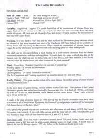
Document - THE UNITED DEVONSHIRE MINE - NOTES ON THE UNITED DEVONSHIRE MINE
... Mines Dept Bulletin No 47 Structure of Bendigo Goldfield H Herman 1923...DOCUMENT Gold the united devonshire mine The United Devonshire Mine Notes on The United Devonshire Mine California Hill State School Freeman & Coy the 'Danes' Princess Alexandra the Premier Coy Saxon & Celt South Devonshire New St Mungo Duke of Edinburgh Phoenix Mine Duchess Tribute Duchess of Edinburgh Albert battery Mines Dept Special Edition Australian Mining Standard 1/6/1899 Mines Dept Booklet Bendigo Goldfields 1936 Mines Dept Annual and Quarterly Reports Annals of Bendigo Mining Sections 1881 - 1916 A Richardson Mines Dept Bulletin No 47 Structure of Bendigo Goldfield H Herman 1923 The Bendigo Goldfield Registry J N Macartney 1/3/1871 One handwritten and three typed copies of notes on The United Devonshire Mine on the New Chum Line of Reef. ...One handwritten and three typed copies of notes on The United Devonshire Mine on the New Chum Line of Reef. Notes include size of lease, depth of shaft, East Shaft, locality, a warning on the area where the shaft is, plant, early history. Leading and Prominent, Best Gold, Total Yields and Dividends. Notes prepared by Albert Richardson.document, gold, the united devonshire mine, the united devonshire mine, notes on the united devonshire mine, california hill state school, freeman & coy, the 'danes', princess alexandra, the premier coy, saxon & celt, south devonshire, new st mungo, duke of edinburgh, phoenix mine, duchess tribute, duchess of edinburgh, albert battery, mines dept special edition australian mining standard 1/6/1899, mines dept booklet bendigo goldfields 1936, mines dept annual and quarterly reports, annals of bendigo mining sections 1881 - 1916, a richardson, mines dept bulletin no 47 structure of bendigo goldfield h herman 1923, the bendigo goldfield registry j n macartney 1/3/1871 -
Bendigo Historical Society Inc.
Map - GEOLOGICAL MAP OF BENDIGO GOLD FIELD
... This map forms part of the Geological Survey of Victoria, Structure of Bendigo Goldfield report, No. 47, 1923. H.Herman, late Director of Geological Survey....This map forms part of the Geological Survey of Victoria, Structure of Bendigo Goldfield report, No. 47, 1923. H.Herman, late Director of Geological Survey. ...Map of Bendigo gold field showing anticlines, synclines, shaft, alluvial deposits and contour lines. Map is in two sections. This map forms part of the Geological Survey of Victoria, Structure of Bendigo Goldfield report, No. 47, 1923. H.Herman, late Director of Geological Survey.Geological Survey Victoriabendigo, gold mining, geological map -
Bendigo Historical Society Inc.
Map - BENDIGO GOLD FIELD LONGITUDINAL VERTICAL PROJECTIONS
... This map forms part of the Geological Survey of Victoria, Structure of Bendigo Goldfield report, No. 47, 1923. H.Herman, late Director of Geological Survey....BENDIGO Gold mining vertical projections Bendigo goldfield gold mining reef lines mining companies geological survey Geological Survey Victoria Bendigo gold field map showing vertical projections of portions of three anticlinal axial planes showing stratigraphical zones and caps of known saddle reefs. This map forms part of the Geological Survey of Victoria, Structure ...Bendigo gold field map showing vertical projections of portions of three anticlinal axial planes showing stratigraphical zones and caps of known saddle reefs. This map forms part of the Geological Survey of Victoria, Structure of Bendigo Goldfield report, No. 47, 1923. H.Herman, late Director of Geological Survey.Geological Survey Victoriabendigo, gold mining, vertical projections, bendigo, goldfield, gold mining, reef lines, mining companies, geological survey -
Bendigo Historical Society Inc.
Map - BENDIGO GOLD FIELD GEOLOGICAL MAP, 1923
... This map forms part of the Geological Survey of Victoria, Structure of Bendigo Goldfield report, No. 47, 1923. H.Herman, late Director of Geological Survey....This map forms part of the Geological Survey of Victoria, Structure of Bendigo Goldfield report, No. 47, 1923. H.Herman, late Director of Geological Survey. ...Geological map of the Bendigo Gold Field showing stratigraphical zones. Map in two sections, colour coded showing anticlines, synclines, shafts, fault lines, fossils. Signed by H. Herman. This map forms part of the Geological Survey of Victoria, Structure of Bendigo Goldfield report, No. 47, 1923. H.Herman, late Director of Geological Survey.Geological Survey Victoriabendigo, gold mining, geological map -
Bendigo Historical Society Inc.
Map - BENDIGO GOLD FIELD GEOLOGICAL MAP
... This map forms part of the Geological Survey of Victoria, Structure of Bendigo Goldfield report, No. 47, 1923. H.Herman, late Director of Geological Survey....This map forms part of the Geological Survey of Victoria, Structure of Bendigo Goldfield report, No. 47, 1923. H.Herman, late Director of Geological Survey. ...Geological map of the Bendigo Gold Field showing stratigraphical zones. Map in two sections, colour coded showing anticlines, synclines, shafts, fault lines, fossils. Signed by H. Herman. This map forms part of the Geological Survey of Victoria, Structure of Bendigo Goldfield report, No. 47, 1923. H.Herman, late Director of Geological Survey.Geological Survey Victoriabendigo, gold mining, geological map -
Bendigo Historical Society Inc.
Map - MAP: VIRGINIA MINE GARDEN GULLY LINE OF REEF
... This map forms part of the Geological Survey of Victoria, Structure of Bendigo Goldfield report, No. 47, 1923. H.Herman, late Director of Geological Survey....This map forms part of the Geological Survey of Victoria, Structure of Bendigo Goldfield report, No. 47, 1923. H.Herman, late Director of Geological Survey. ...Map of Virginia Mine on the Garden Gully line of reef, Eaglehawk, transverse section. Shaft, levels and Garden Gully anticlinal axial line drawn. Key shows types of formations - quartz, spurs, sandstone, slate, cleavage, lava. This map forms part of the Geological Survey of Victoria, Structure of Bendigo Goldfield report, No. 47, 1923. H.Herman, late Director of Geological Survey.Geological Survey Victoria, Geological Survey Office, Bendigo.bendigo, gold mining, virgina mine eaglehawk, eaglehawk, bendigo, gold mining, virginia mine, garden gully line of reef. -
 Federation University Historical Collection
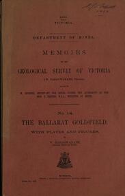
Book, Memoirs of the Geological Survey of Victoria No 14 The Ballarat Goldfields, 1923, 1923
... Contents include topography, physiography, historical, geology, basalt, faults, dykes, minerals leads, alluvial mines, nuggets, structure of Ballarat West goldfields, structure of Ballarat East gold-field, quartz formation, indicators, defunct mines, existing mines, table of deepest shafts. ...Contents include topography, physiography, historical, geology, basalt, faults, dykes, minerals leads, alluvial mines, nuggets, structure of Ballarat West goldfields, structure of Ballarat East gold-field, quartz formation, indicators, defunct mines, existing mines, table of deepest shafts. ...William Baragwanath was educated at the Ballarat School of Mines, obtaining a Geology Certificate in 1911. After further study he went on the become Secretary for Mines, and Chief Mining Surveyor. Baragwanath was a Councillor of the Ballarat School of Mine from 1916 to 1950.Pink covered foolscap book of 257 pages and 32 maps and plans by William Baragwanath. Contents include topography, physiography, historical, geology, basalt, faults, dykes, minerals leads, alluvial mines, nuggets, structure of Ballarat West goldfields, structure of Ballarat East gold-field, quartz formation, indicators, defunct mines, existing mines, table of deepest shafts. Images include: section of the Ballarat Gold-Field, Dead HOrse Flat, lakes formed by Basalt Flows, Gong Gong Creek, Frenchman's Lead, Ballarat West Mines, LEases and positions of shafts (1857), puddling, White Horse Lead, Woah Hawp Canton, Ballarat Township mines, Sebastopol, syncline, Victoria United Line, First Chance Mine, Llanberris No 1 Mine, Saddle Reef, New Normanby Mine, Woah Hawp Canton Mine, South Star Mine, Sebastopol Plateau, south Woah Hawp Mine, Woah No. 2 Minegeology, geological survey no 14, ballarat, baragwanath, william baragwanath -
Bendigo Historical Society Inc.
Map - BENDIGO GOLDFIELD VERTICAL PROJECTIONS
... This map forms part of the Geological Survey of Victoria, Structure of Bendigo Goldfield report, No. 47, 1923. H.Herman, late Director of Geological Survey. ...This map forms part of the Geological Survey of Victoria, Structure of Bendigo Goldfield report, No. 47, 1923. H.Herman, late Director of Geological Survey. ...Map of Bendigo Gold Field in two sections showing 'vertical projections along several anticlinal axial planes showing pitch, stratigraphical zones, faultlines, shafts and etc.'. Bulletin No 47 written top left hand side. Lines of reef described: Christmas line Lancashire line Nell Gwynne line New Chum line Hustlers line Garden Gully line Sheepshead line Mines along the reef lines are listed. This map forms part of the Geological Survey of Victoria, Structure of Bendigo Goldfield report, No. 47, 1923. H.Herman, late Director of Geological Survey. On bottom of second section : Prepared in the Geological Survey Office, Bendigo, under the direction of H. Herman, late Director of Geological Survey, from surveys by H.S. Whitelaw, Field Geologist, assisted by E.S. Usher, A.J.J. Moore and R.A. Keble.Geological Survey of Victoriabendigo, gold mining, reef lines -
Bendigo Historical Society Inc.
Map - SECTIONS ACROSS BENDIGO GOLDFIELD
... This map forms part of the Geological Survey of Victoria, Structure of Bendigo Goldfield report, No. 47, 1923. H.Herman, late Director of Geological Survey....This map forms part of the Geological Survey of Victoria, Structure of Bendigo Goldfield report, No. 47, 1923. H.Herman, late Director of Geological Survey. ...Map in three sections showing sections across Bendigo Gold Field, showing anticlines, synclines, faults, stratigraphical zones and mines along the reef lines. Key shows rock types Castlemaine, Bendigo B1, B2, B3 and B4, and Lancefieldian. First part of map shows sections A-A, B-B and C-C. Reef lines drawn with mines listed: Fault line shown are the Carshalton, Stafford, New Chum, Virginia and Clarence. A datum line shows 600 ft above sea level. On bottom of plan: ' Prepared in the Geological Survey Office, Bendigo, under the direction of H. Herman, late Director of Geological Survey, from surveys by H.S. Whitelaw, Field Geologist, assisted by E.S. Usher, A.J.J. Moore and R.A. Keble.' Second section of map shows sections D-D, and E-E. Fault lines listed are the Tambour Major fault, Carshalton fault, Stafford fault, Nell Gwynne fault, New Chum fault, Deborah fault. Third section shows sections F-F and G-G. Fault lines listed are the Bird Reef fault, Kangaroo Gully fault, Langdon fault, Carshalton fault, Nell Gwynne fault, Spring Gully fault, Hustlers fault, Gravel Hill fault, Ordes fault, Thanet fault. This map forms part of the Geological Survey of Victoria, Structure of Bendigo Goldfield report, No. 47, 1923. H.Herman, late Director of Geological Survey.Geological Survey of Victoriabendigo, gold mining, reef line maps -
 The Beechworth Burke Museum
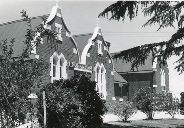
Photograph, J. Collins, c.1940-1950s
... This marks a movement away from the "chaotic" structure of life on the goldfields and towards a more civilised and cultural lifestyle. ...This marks a movement away from the "chaotic" structure of life on the goldfields and towards a more civilised and cultural lifestyle. ...This photograph was captured sometime between an estimated 1940s-1950s. It depicts the Beechworth Benevolent Asylum (later the Ovens and Murray Hospital for the Aged) which was built in 1862. It is located on an elevated site in Beechworth, Victoria because it was believed the height was beneficial to the health of the patients at the Benevolent. Later wings were added to the original building between 1867 and 1890. The building was constructed in an unusual Flemish Gothic Revival style which contrasts with the classical style of the Mayday Hills Hospital in close proximity to the Benevolent. The Hospital was designed in Italianate Revival architecture. The appearance of buildings like the Mayday Hills Hospital and the Ovens Benevolent Asylum are representative of the importance of Beechworth as a town shortly after the goldrush. During the 1850s and 1860s, administration buildings were erected alongside churches, shops and structures of justice. This marks a movement away from the "chaotic" structure of life on the goldfields and towards a more civilised and cultural lifestyle. This social phenomenon is also witnessed in Melbourne with the creation of buildings like the State Library and the University of Melbourne. The Beechworth Benevolent Asylum was renamed the Ovens Benevolent Home in 1935. The Asylum had been set up to provide accommodation and care for permanently injured gold miners, and for women and children who were penniless, homeless, or whose parents were guests of the state. In 1954 it was renamed as The Ovens and Murray Home (as pictured in this photograph). The purpose of this building was to provide a refuge for the poor and destitute, homeless older men, deserted women and children along with providing care for the mentally ill. These buildings were built at the government's expense and are of great historical and architectural significance.This photograph depicts the Ovens and Murray Home (previously the Ovens Benevolent Home) during the 1940s or 1950s. Since this building is of great historic and architectural significance, photographs like this are especially valuable in reconstructing the use history and any changes/additions to the building over a period of time. This building is important for what it can reveal about society in Beechworth and also architectural styles. This building is made in the Flemish Gothic Revival style which is quite unusual for the 1860s. It is important as an early example of a building constructed for a specific purpose, in the case of this particular building: caring for the aged/destitute. This building is important for research into the civic development of Beechworth as an early Gold Rush town located in Victoria's North-East. During this period, Beechworth was developing as the main center of administration in this region which made it a very influential and quickly developed town. Photographs like this one which depict a building during one period in history can reveal important information for the use and alterations of a building and for preferences in architectural style. It can also be studied for what it reveals about society in Beechworth and compared and contrasted to similar institutions across Australia and with additional photographs in the Burke Museum collection.Black and white rectangular photograph printed on gloss photographic paperObverse: OVENS & MURRAY HOME / Reverse: KODAK PAPER / 727 / J. Collins BMM 8689.1 /mayday hills, beechworth benevolent asylum, ovens benevolent home, asylum, refuge, poor and destitute, goldrush, flemish gothic revival, architecture -
 The Beechworth Burke Museum
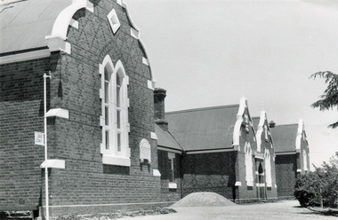
Photograph, J. Collins
... This marks a movement away from the "chaotic" structure of life on the goldfields and towards a more civilised and cultural lifestyle. ...This marks a movement away from the "chaotic" structure of life on the goldfields and towards a more civilised and cultural lifestyle. ...This photograph was captured sometime between an estimated 1940s-1950s. It depicts the Beechworth Benevolent Asylum (later the Ovens and Murray Hospital for the Aged) which was built in 1862. It is located on an elevated site in Beechworth, Victoria because it was believed the height was beneficial to the health of the patients at the Benevolent. Later wings were added to the original building between 1867 and 1890. The building was constructed in an unusual Flemish Gothic Revival style which contrasts with the classical style of the Mayday Hills Hospital in close proximity to the Benevolent. The Hospital was designed in Italianate Revival architecture. The appearance of buildings like the Mayday Hills Hospital and the Ovens Benevolent Asylum are representative of the importance of Beechworth as a town shortly after the goldrush. During the 1850s and 1860s, administration buildings were erected alongside churches, shops and structures of justice. This marks a movement away from the "chaotic" structure of life on the goldfields and towards a more civilised and cultural lifestyle. This social phenomenon is also witnessed in Melbourne with the creation of buildings like the State Library and the University of Melbourne. The Beechworth Benevolent Asylum was renamed the Ovens Benevolent Home in 1935. The Asylum had been set up to provide accommodation and care for permanently injured gold miners, and for women and children who were penniless, homeless, or whose parents were guests of the state. In 1954 it was renamed as The Ovens and Murray Home (as pictured in this photograph). The purpose of this building was to provide a refuge for the poor and destitute, homeless older men, deserted women and children along with providing care for the mentally ill. These buildings were built at the government's expense and are of great historical and architectural significance.This photograph depicts the Ovens and Murray Home (previously the Ovens Benevolent Home) during the 1940s or 1950s. Since this building is of great historic and architectural significance, photographs like this are especially valuable in reconstructing the use history and any changes/additions to the building over a period of time. This building is important for what it can reveal about society in Beechworth and also architectural styles. This building is made in the Flemish Gothic Revival style which is quite unusual for the 1860s. It is important as an early example of a building constructed for a specific purpose, in the case of this particular building: caring for the aged/destitute. This building is important for research into the civic development of Beechworth as an early Gold Rush town located in Victoria's North-East. During this period, Beechworth was developing as the main center of administration in this region which made it a very influential and quickly developed town. Photographs like this one which depict a building during one period in history can reveal important information for the use and alterations of a building and for preferences in architectural style. It can also be studied for what it reveals about society in Beechworth and compared and contrasted to similar institutions across Australia and with additional photographs in the Burke Museum collection.Black and white rectangular photograph printed on gloss photographic paperBack of photograph. Handwriting: "For John Beckingsale"mayday hills, beechworth benevolent asylum, ovens benevolent home, destitute, gold town, beechworth, victoria, north-east vic -
 The Beechworth Burke Museum
Photograph - Stereoscopic Photograph, Unknown c1875
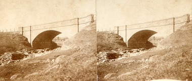
... Beechworth held a distinct role in the administrative and commercial management of Victoria's north-eastern goldfields, with many objects and structures still well preserved from the towns establishment. ...Beechworth held a distinct role in the administrative and commercial management of Victoria's north-eastern goldfields, with many objects and structures still well preserved from the towns establishment. ...Depicted in the photograph is Newtown Bridge or the Newtown Falls Bridge, in Beechworth, Victoria. Noted for its location, detailed craftsmanship and stonemasonry by Scottish stonemasons the Newtown Bridge was built in the 19th century provincial town of Beechworth (completed in 1875). The bridge was built over Spring Creek, spanning 6.3 meters wide and 24.8 meters tall. Beechworth held a distinct role in the administrative and commercial management of Victoria's north-eastern goldfields, with many objects and structures still well preserved from the towns establishment. The bridge indicates the growth of the town, replacing a previous timber structure as well as its association to the mining activity in the area and the rapid increase in Australia's economy that led to investment and development of roads and railways. The local granite used in the construction of the single arch Newtown Bridge makes the bridge and other buildings made with the granite unique to the area, the honey-toned material distinct to Beechworth. This photograph is historically significant as it provides insight into the industrial development of Beechworth and the surrounding area, contributed to by the goldfields. The photograph further captures the representation of vernacular engineering traditions and Scottish stonemasonry.Two sepia-toned rectangular photographs featuring a bridge in the background printed on matte photographic paper mounted on card.Reverse: 97.2324/ Newtown Bridge/ Beechworthbridge, newtown beechworth, newtown bridge, newtown, beechworth, beechworth falls bridge, beechworth mining district, spring creek, -
Federation University Historical Collection
Book, New York Post, The School of Mine Quarterly: A Journal of Applied Science, 1889-1809
... The School of Mines Quarterly was a jpournal of Applied Science from Columbia College, New York City. school of mines new york columbia college schools of mines columbia school of mines Witwatersrand Goldfield INter-continental Railway Mine Ropes Harbor improvememnts on the Pacific coast Glycerine and artificial Butter industry Transit Factors for teh Columbia College Observatory Tables for the Reducation of Transit Observations Ancienct methods for dividing and Recoording time in Japan Assay of tin John Strong Newberry Standards of linnear Measure Comparison of costs of electric lighting Huanchaca Mine Bolivia El Callao Gold Mine Venezuela John Magnus Adams Ores in Saxony Hartz and Rhenish Prussia Hofmann Apparatus Adjustment of Trangulation Determination of Carbonic Acid in White Lead Lower Coals in Western Clearfield County Pennsylvania Old Telegraph Mine Ningham Canon Utah mechanical Preparation of Ores modern waterworks construction curdling of milk French regenerative gas furnace Irrication Canals peruvian salt mine Collection of Metallurgic Dust and fume Permeability of iron and steel Assay of Silver Explosion in a Zinc Fume condenser Teaching archtectural history Liquid air between the mine and the smelter Ballistic Galvonometer Assay of Telluride ores Analytical Chemistry Theory and design of the masonry arch silver pick mine Wilson colorado telegraphy and telephoney mineralogy morse code Michigan mining practices Titaniferous magnetites paradox of the pantheon Rocks from Wyoming Witwatersrand goldfields Gaseous sun Alternating current distribution Engineering tests on direct current Electrical Machinery Thomas Egleston Ore dressing Frederick Morgan Watson Camp Bird Gold Mine and Mills Magnetic properties of Iron and Steel Morphology of Organic compounds Antimony structure of the Starch Molecule Cerrillos Hills New Mexico geology Rossie Lead Veins practical electrochemistry lines of graphic statics Anistic Acid by the ozidation of Anniseed Oil Bromate method for antimony John Krom Rees Trust company of America Building Helion lamp Frederick Arthur Goetze Mine Surveying Pine Wood Oils Malleable Cast iron Electrolytic treatment of Galena turpentine and pine oils Bluestone Ashokan Dam bluestone road resistances Oxy-gas blowtorch Mine dumps segregation of steel ingots masonry dam formulas putnam county magnetic belts gases Continuity of education Hydraulic diagrams standardistion of Potassium permanganate Sewerage Discharge into Sea Water Modern waterworks True Column formula Slags from lead furnaces missouri river tempreture of gases rocks architectural history Modern dome oil machine undulations in railway tracks Irrigation engineering Cleps-tachymeters Electrical Engineering New York Shales fan pump Sucrose Isaac Newton French school of anstronomers Electrolytic polarization Benjamin bowden lawrence diamond drilling New York Ciy Water Front Engineering profession ethics The Index to the School of Mines Quarterlu Volumes X1-XX (1900) and 32 green covered journals The School of Mine Quarterly: A Journal of Applied Science Book New York Post ...The School of Mines Quarterly was a jpournal of Applied Science from Columbia College, New York City.The Index to the School of Mines Quarterlu Volumes X1-XX (1900) and 32 green covered journals school of mines, new york, columbia college, schools of mines, columbia school of mines, witwatersrand goldfield, inter-continental railway, mine ropes, harbor improvememnts on the pacific coast, glycerine and artificial butter industry, transit factors for teh columbia college observatory, tables for the reducation of transit observations, ancienct methods for dividing and recoording time in japan, assay of tin, john strong newberry, standards of linnear measure, comparison of costs of electric lighting, huanchaca mine bolivia, el callao gold mine venezuela, john magnus adams, ores in saxony, hartz and rhenish prussia, hofmann apparatus, adjustment of trangulation, determination of carbonic acid in white lead, lower coals in western clearfield county pennsylvania, old telegraph mine ningham canon utah, mechanical preparation of ores, modern waterworks construction, curdling of milk, french regenerative gas furnace, irrication canals, peruvian salt mine, collection of metallurgic dust and fume, permeability of iron and steel, assay of silver, explosion in a zinc fume condenser, teaching archtectural history, liquid air, between the mine and the smelter, ballistic galvonometer, assay of telluride ores, analytical chemistry, theory and design of the masonry arch, silver pick mine wilson colorado, telegraphy and telephoney, mineralogy, morse code, michigan mining practices, titaniferous magnetites, paradox of the pantheon, rocks from wyoming, witwatersrand goldfields, gaseous sun, alternating current distribution, engineering tests on direct current electrical machinery, thomas egleston, ore dressing, frederick morgan watson, camp bird gold mine and mills, magnetic properties of iron and steel, morphology of organic compounds, antimony, structure of the starch molecule, cerrillos hills new mexico, geology, rossie lead veins, practical electrochemistry, lines of graphic statics, anistic acid by the ozidation of anniseed oil, bromate method for antimony, john krom rees, trust company of america building, helion lamp, frederick arthur goetze, mine surveying, pine wood oils, malleable cast iron, electrolytic treatment of galena, turpentine and pine oils, bluestone, ashokan dam bluestone, road resistances, oxy-gas blowtorch, mine dumps, segregation of steel ingots, masonry dam formulas, putnam county magnetic belts, gases, continuity of education, hydraulic diagrams, standardistion of potassium permanganate, sewerage discharge into sea water, modern waterworks, true column formula, slags from lead furnaces, missouri river, tempreture of gases, rocks, architectural history, modern dome, oil machine, undulations in railway tracks, irrigation engineering, cleps-tachymeters, electrical engineering, new york shales, fan pump, sucrose, isaac newton, french school of anstronomers, electrolytic polarization, benjamin bowden lawrence, diamond drilling, new york ciy water front, engineering profession ethics -
 Federation University Historical Collection
Book, J.W. Gregory, Memoirs of the Geological Survey of Victoria No. 4: The Ballarat East Gold-Field, 1907, 1907
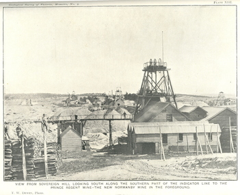
... Little Bendigo Goldfield, Ballarat West Goldfield, Ballarat East Goldfield, history, nuggets, indicators, faults, microscopic structure of Ballarat Rocks and ores, general type of the Ballarat East Mines and the genesis of their ores. ...Little Bendigo Goldfield, Ballarat West Goldfield, Ballarat East Goldfield, history, nuggets, indicators, faults, microscopic structure of Ballarat Rocks and ores, general type of the Ballarat East Mines and the genesis of their ores. ...Blue soft covered report with 40 plates and plans. Inciudes Geology of Ballarat. Little Bendigo Goldfield, Ballarat West Goldfield, Ballarat East Goldfield, history, nuggets, indicators, faults, microscopic structure of Ballarat Rocks and ores, general type of the Ballarat East Mines and the genesis of their ores. Mines include New Zealand Trust, Llanberris No. 1, Llanberris No 2, Victoria United, Britannia United, New Britannia, Last Chance, Exchange, Normanby North, New Normanby, North Woah Hawp. Photpgraphic plates include: Victoria United Mine, Llanberres No. 1, Normanby North, North Woah Hawp Mine, View looking south from the Britannia Mullock Heap, View from Sovereign Hill, The place in Learmonth Street Golden Point where gold was first discovered at Ballarat. j.w. gregory, ballarat east, ballarat east goldfield, e.j. dunn, geolological survey of victoria, new zealand trust, llanberris no. 1, llanberris no 2, victoria united, britannia united, new britannia, last chance, exchange, normanby north, new normanby, north woah hawp, mining, indicators, gold mining, poppet head -
 Orbost & District Historical Society
black and white photograph, late 19th century - early 20th century
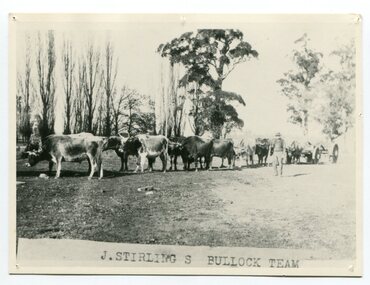
... James Stirling moved around a lot to Whittlesea, Ballarat goldfields, Cunninghame, (now Lakes Entrance), then to the Old Station about 36 miles to the east along the coast near the mouth of the Snowy River and for a time settled there with his wife also from Wigton, Scotland, and their family four sons two daughters (James, John, William, George, Margaret and Polly). The first settler to occupy the Marlo township area was James Stirling around the year 1875. He built a bark hut on the bluff that had two rooms, bark walls, earthen floors and a shingle roof. By 1884, this structure...James Stirling moved around a lot to Whittlesea, Ballarat goldfields, Cunninghame, (now Lakes Entrance), then to the Old Station about 36 miles to the east along the coast near the mouth of the Snowy River and for a time settled there with his wife also from Wigton, Scotland, and their family four sons two daughters (James, John, William, George, Margaret and Polly). The first settler to occupy the Marlo township area was James Stirling around the year 1875. He built a bark hut on the bluff that had two rooms, bark walls, earthen floors and a shingle roof. By 1884, this structure ...Aged 19 James Stirling arrived in Melbourne on January 26, 1842 with his family - parents, three sisters and two brothers. James Stirling moved around a lot to Whittlesea, Ballarat goldfields, Cunninghame, (now Lakes Entrance), then to the Old Station about 36 miles to the east along the coast near the mouth of the Snowy River and for a time settled there with his wife also from Wigton, Scotland, and their family four sons two daughters (James, John, William, George, Margaret and Polly). The first settler to occupy the Marlo township area was James Stirling around the year 1875. He built a bark hut on the bluff that had two rooms, bark walls, earthen floors and a shingle roof. By 1884, this structure had expanded to a 9 roomed accommodation house and in 1886 became the Marlo Hotel when a liquor license was granted. (more information from “Snowy River Mail”, Wednesday, April 13th 1977: MEMORIES OF MARLO by Mrs Elsbeth Conlon (nee Stirling ) During the 19th century bullock teams were the most effective means of transporting people and goods inland, as the roads were badly made and in poor condition. The better roads were closer to the towns, and the further away from the town, the worse the conditions of the roads. Bullock teams drew heavily laden carts full of provisions, equipment and people from town to town and into the countryside to isolated homes. This item is associated with that era. It is also associated with James Sterling a very early settler of Marlo.A black / white photograph of a bullock team with a man standing beside it.on front - J STIRLING S BULLOCK TEAMstirling-james marlo-history bullock-team transport -
 Orbost & District Historical Society
black and white photograph, July 1922
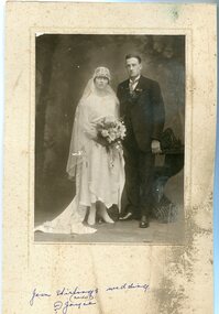
... James Stirling moved around a lot to Whittlesea, Ballarat goldfields, Cunninghame, (now Lakes Entrance), then to the Old Station about 36 miles to the east along the coast near the mouth of the Snowy River and for a time settled there with his wife also from Wigton, Scotland, and their family four sons two daughters (James, John, William, George, Margaret and Polly). The first settler to occupy the Marlo township area was James Stirling around the year 1875. He built a bark hut on the bluff that had two rooms, bark walls, earthen floors and a shingle roof. By 1884, this structure...James Stirling moved around a lot to Whittlesea, Ballarat goldfields, Cunninghame, (now Lakes Entrance), then to the Old Station about 36 miles to the east along the coast near the mouth of the Snowy River and for a time settled there with his wife also from Wigton, Scotland, and their family four sons two daughters (James, John, William, George, Margaret and Polly). The first settler to occupy the Marlo township area was James Stirling around the year 1875. He built a bark hut on the bluff that had two rooms, bark walls, earthen floors and a shingle roof. By 1884, this structure ...Jean Stirling , born 1901 in Orbost, married Charles Frances Reginald Joyes on 15th July 1922 in Orbost. Jean's father was John Stirling, son of James Stirling and Ann Gray. Her mother was Robina Harvey McNair, Aged 19 James Stirling arrived in Melbourne on January 26, 1842 with his family - parents, three sisters and two brothers. James Stirling moved around a lot to Whittlesea, Ballarat goldfields, Cunninghame, (now Lakes Entrance), then to the Old Station about 36 miles to the east along the coast near the mouth of the Snowy River and for a time settled there with his wife also from Wigton, Scotland, and their family four sons two daughters (James, John, William, George, Margaret and Polly). The first settler to occupy the Marlo township area was James Stirling around the year 1875. He built a bark hut on the bluff that had two rooms, bark walls, earthen floors and a shingle roof. By 1884, this structure had expanded to a 9 roomed accommodation house and in 1886 became the Marlo Hotel when a liquor license was granted. (more information from “Snowy River Mail”, Wednesday, April 13th 1977: MEMORIES OF MARLO by Mrs Elsbeth Conlon (nee Stirling )This photograph is associated with the Stirling family early settlers of Marlo. It is also a pictorial record of styles of wedding dress popular in the 1920s.A black / white studio portrait / photograph of a bridal couple. The bride on the left is wearing a typical 1920s wedding dress. tTe front is short with a hem that is in different length in front than behind. She is wearing a hat in the cloche-style. She is holding a bouquet of flowers and her train is draped to the left. The groom is wearing a three piece morning suit. he has a with a wingtip collar white dress shirt and a cravat tie.on front - hand - written "Jean Stirling's wedding (Marlo) ? Joyce"stirling-jean-wedding melba-&co wedding-clothing-1920s joyes-charles-francis-reginald -
 Eltham District Historical Society Inc
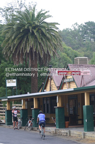
Photograph - Digital Photograph, Alan King, St Andrews Hotel, 2 February 2008
... It is also significant as the oldest hotel building in the former Shire of Eltham, as one of the few surviving buildings connected with the Caledonian goldfields era and as one of a handful of early structures to have survived the 1960s bushfires; the additions and alterations to the hotel reflect its long life. ...It is also significant as the oldest hotel building in the former Shire of Eltham, as one of the few surviving buildings connected with the Caledonian goldfields era and as one of a handful of early structures to have survived the 1960s bushfires; the additions and alterations to the hotel reflect its long life. ...The c1860 St Andrews Hotel, with the c1930 additions, and the Canary Island Palm, and the surrounding site to the title boundaries are historically, socially and aesthetically significant to the Shire of Nillumbik. The St Andrews Hotel is historically significant because it may have given its name 'St Andrews' to the town (another suggestion is that the name came from St Andrews church) and for its connection to Ewen Hugh Cameron (1831-1915) the prosperous local farmer, member of the Eltham Roads Board/Shire Council and local MP. It is also significant as the oldest hotel building in the former Shire of Eltham, as one of the few surviving buildings connected with the Caledonian goldfields era and as one of a handful of early structures to have survived the 1960s bushfires; the additions and alterations to the hotel reflect its long life. The hotel is socially significant because it has served as an important meeting place for more than 160 years. The Canary Island Palm is historically significant as a rare example of exotic tree planting in this rural area. The tree is aesthetically and historically significant as a local landmark and for its contribution to the streetscape and landscape value. Covered under Heritage Overlay, Nillumbik Planning Scheme. Published: Nillumbik Now and Then / Marguerite Marshall 2008; photographs Alan King with Marguerite Marshall.; p71 Built around 1860, St Andrews Hotel has changed little since it first welcomed thirsty gold diggers from the Caledonia Goldfields. The timber building, with gabled roof, beamed ceilings and a massive fireplace, is Nillumbik Shire’s oldest hotel and has always been an important community centre, particularly in its early days. Fortunately, the hotel and the near-by Canary Island Palm Tree, which is quite rare in this area, survived the 1960s bushfires, along with a few other early buildings. St Andrews (formerly Queenstown) was founded on gold, as were Panton Hill (formerly Kingstown), Research and Diamond Creek, from the mid-1850s to the 1860s. But by the early 20th century common use changed the name Queenstown to St Andrews, possibly after this hotel or after the church or the mining district.1 The Caledonia Diggings were probably named by Scottish settlers after the Roman name for Scotland, despite this land bearing little similarity to their homeland.2 Queenstown, which was proclaimed as a township in 1861, was the gold-mining centre on the Upper Diamond and in the 1850s had up to 600 European inhabitants and a small camp of Chinese on the flats along the creek. Queenstown was the administrative centre of the Upper Diamond with three hotels, a brewery and a slaughterhouse.3 It is unclear which hotel was the district’s first, as distinct from the earliest unlicensed grog shops, some of which operated in tents. John Corke Knell was one of eight unlicensed storekeepers supplying drink to miners at Caledonia in 1857, named by Sgt. McNamara of the Caledonia Police Station.4 In February 1859, Knell apparently bought most of the present hotel’s site at the first township land sales. As he was a local storekeeper, he might have first established a store there.5 Knell and his wife Eliza were early licensees of the St Andrews Hotel. The hotel had eight bedrooms – including three for public use – and the dining-room seated 30 people. It is thought they named the hotel St Andrews after Eliza’s hometown of St Andrews in Scotland. St Andrews Hotel was an important local centre in several ways. In the same building the Knells also operated a post office and general store. In 1867 Mrs Knell was appointed Deputy Registrar of Births and Deaths for Queenstown. The hotel was also used to hold inquests into people’s deaths when the police residence became too small.6 The hotel also became a fashionable destination at Christmas for parties from Melbourne. In 1868, possibly following her husband’s death, Mrs Knell applied for a temporary licence, which was then transferred to Robert Smith after their marriage in 1869. But then, possibly after Robert’s death, Mrs Smith operated the hotel until 1892. This contradicts a report in The Evelyn Observer 1882 that JC Knells of the St Andrews Hotel was granted a publican’s licence in the Queenstown Police Court. At that time he was supposed to have been dead for around 14 years! Although Mrs Smith was a respected citizen, known for her geniality and as an ideal hostess, she had a minor brush with the law when she was fined ten shillings for not lighting a lamp outside her licensed premises.7 From 1892 several publicans owned the hotel including W Atkins, from 1895. In 1909 the licensee was apparently Mrs Smith’s son, Walter Knell, who held the licence until at least the 1920s. Not surprisingly, this old hotel has attracted romantic stories. Mrs Smith is said to be seen roaming the pub in her nightdress – even though she was buried in the Queenstown Cemetery in 1911.8 A musical The Hero of Queenstown, set in the hotel, was written and produced by local actor Reg Evans in the 1970s.This collection of almost 130 photos about places and people within the Shire of Nillumbik, an urban and rural municipality in Melbourne's north, contributes to an understanding of the history of the Shire. Published in 2008 immediately prior to the Black Saturday bushfires of February 7, 2009, it documents sites that were impacted, and in some cases destroyed by the fires. It includes photographs taken especially for the publication, creating a unique time capsule representing the Shire in the early 21st century. It remains the most recent comprehenesive publication devoted to the Shire's history connecting local residents to the past. nillumbik now and then (marshall-king) collection, st andrews hotel -
 Eltham District Historical Society Inc
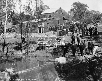
Negative - Photograph, Opening of St. Andrews Battery, Queenstown, 29 Aug. 1919
... goldfield. The miners of Queenstown, who through long year's had never lost faith in the possibilities of the field, felt that the purpose for which they were that day marked the beginning of a new era in the history of local reefing. …. The new mill is situated on the bank of the creek opposite the Queenstown Cemetery, and consists of a five head battery (Berdan pan) and 12 h.p. portable steam engine housed in a spacious structure of wood and iron. ...goldfield. The miners of Queenstown, who through long year's had never lost faith in the possibilities of the field, felt that the purpose for which they were that day marked the beginning of a new era in the history of local reefing. …. The new mill is situated on the bank of the creek opposite the Queenstown Cemetery, and consists of a five head battery (Berdan pan) and 12 h.p. portable steam engine housed in a spacious structure of wood and iron. ...Reproduced on p31 of 'Pioneers & Painters' Was destroyed in 1962 bushfire. Now Peter Franks Reserve, St Andrews On Friday 29th (August 1919) …, the Hon. S. Barnes, M. L. A., Minister of Mines, accompanied by Mr W. Everard, M.L.A., Mr. V. Dickson, secretary for Mines, and Mr. Merrin, Chief Mining Inspector, visited Smith's Gully for the purpose of opening, the new Government battery which has recently been erected. The party arrived punctually at 12.30, and was received by an assemblage of about 200 residents, including, those representing local prospecting and mining interests. At the mill house the Minister wished prosperity to mining on the old Queenstown field, and, in a few appropriate remarks, gave the battery the name of St. Andrew's. Then, as the stamps began to fall, three hearty cheers were given by the gathering. ….. The Queenstown field, dating back to the early sixties, might be regarded as a link that took them back to the Augustine age of gold mining in Victoria…From 1868 to 1918 the total yield of gold from the field was 274,606 fine oz. It might be that here, as elsewhere, deeper prospecting would give new life to the Queenstown goldfield. The miners of Queenstown, who through long year's had never lost faith in the possibilities of the field, felt that the purpose for which they were that day marked the beginning of a new era in the history of local reefing. …. The new mill is situated on the bank of the creek opposite the Queenstown Cemetery, and consists of a five head battery (Berdan pan) and 12 h.p. portable steam engine housed in a spacious structure of wood and iron. A concrete weir across the creek provides a good water supply, and all the necessary pumps, settling dams, etc., have been installed. Later on, should circumstances warrant it, it is pro-posed to erect Wilfley tables for concentrates. Eltham and Whittlesea Shires Advertiser and Diamond Creek Valley Advocate, Friday 5 September 1919, page 3This photo forms part of a collection of photographs gathered by the Shire of Eltham for their centenary project book,"Pioneers and Painters: 100 years of the Shire of Eltham" by Alan Marshall (1971). The collection of over 500 images is held in partnership between Eltham District Historical Society and Yarra Plenty Regional Library (Eltham Library) and is now formally known as the 'The Shire of Eltham Pioneers Photograph Collection.' It is significant in being the first community sourced collection representing the places and people of the Shire's first one hundred years.Digital image 4 x 5 inch B&W Neg Print 20 x 25 (2)shire of eltham pioneers photograph collection, queenstown, st andrews, st. andrews battery, gold mining, s. barnes, merrin, st andrews battery, v. dickson, william h. everard, peter franks reserve -
 Bendigo Historical Society Inc.
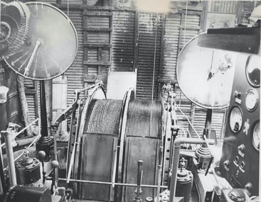
Photograph - AUSTIN COLLECTION: Wattle Gully Gold Mine, Chewton, Not dated but possibly 1980's
... Goldfields. The mine site has retained evidence of its development since 1937 with its most recent periods of equipment upgrades in the 1950s and 1980s being documented by buildings, structures and intact and working machinery. ...Goldfields. The mine site has retained evidence of its development since 1937 with its most recent periods of equipment upgrades in the 1950s and 1980s being documented by buildings, structures and intact and working machinery. ...Wattle Gully Mine holds a pivotal position in the history of the State's quartz mining industry. The rich strike at Wattle Gully mine in 1937 helped revive the State's gold mining industry that had been in the doldrums since the First World War. Wattle Gully, and a handful of other 'new' companies - the Maude and Yellow Girl, Morning Star, A 1, and North Deborah - were the flagships of the revived industry and sustained the State's gold production for some 30 years. Wattle Gully mine, with a yield of 350,000 ounces, was the richest mine of its era. By 1940, the Wattle Gully Company had paid out £207,000 in dividends to its shareholders. The company continued to mine profitably through the Second World War, though it struggled due to a shortage of manpower. After the war, the mine continued to develop - in the early 1950s new plant including a winding engine, steel poppet head, and twenty-head battery was added. The plant was obtained from the Central Nell Gwynne Company, Bendigo. On 13 March 1969, the Wattle Gully Company closed down the mine, laying off 62 men. Since 1970 Wattle Gully mine has worked intermittently. Recent additions to the mine's infrastructure has been a new ore processing plant and a decline tunnel. The ore processing plant was operated by Newmont mining from 1987 to 1990 and subsequently operated by Consolidated Victorian Mines and Duketon Goldfields. The mine site has retained evidence of its development since 1937 with its most recent periods of equipment upgrades in the 1950s and 1980s being documented by buildings, structures and intact and working machinery. Heritage Council Victoria: https://vhd.heritagecouncil.vic.gov.au/places/2380 Black and white photograph: view of engine room. Wattle Gully Gold Mine winding gear, two winding wheels in centre of image.gold mining, underground, wattle gully gold mine, chewton, winding gear -
 Bendigo Historical Society Inc.
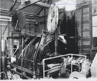
Photograph - AUSTIN COLLECTION: Winding Gear, Wattle Gully Gold Mine, Chewton, 1982
... Goldfields. The mine site has retained evidence of its development since 1937 with its most recent periods of equipment upgrades in the 1950s and 1980s being documented by buildings, structures and intact and working machinery. ...Goldfields. The mine site has retained evidence of its development since 1937 with its most recent periods of equipment upgrades in the 1950s and 1980s being documented by buildings, structures and intact and working machinery. ...Wattle Gully Mine holds a pivotal position in the history of the State's quartz mining industry. The rich strike at Wattle Gully mine in 1937 helped revive the State's gold mining industry that had been in the doldrums since the First World War. Wattle Gully, and a handful of other 'new' companies - the Maude and Yellow Girl, Morning Star, A 1, and North Deborah - were the flagships of the revived industry and sustained the State's gold production for some 30 years. Wattle Gully mine, with a yield of 350,000 ounces, was the richest mine of its era. By 1940, the Wattle Gully Company had paid out £207,000 in dividends to its shareholders. The company continued to mine profitably through the Second World War, though it struggled due to a shortage of manpower. After the war, the mine continued to develop - in the early 1950s new plant including a winding engine, steel poppet head, and twenty-head battery was added. The plant was obtained from the Central Nell Gwynne Company, Bendigo. On 13 March 1969, the Wattle Gully Company closed down the mine, laying off 62 men. Since 1970 Wattle Gully mine has worked intermittently. Recent additions to the mine's infrastructure has been a new ore processing plant and a decline tunnel. The ore processing plant was operated by Newmont mining from 1987 to 1990 and subsequently operated by Consolidated Victorian Mines and Duketon Goldfields. The mine site has retained evidence of its development since 1937 with its most recent periods of equipment upgrades in the 1950s and 1980s being documented by buildings, structures and intact and working machinery. Heritage Council Victoria: https://vhd.heritagecouncil.vic.gov.au/places/2380 Black and white photograph: view of engine room. Wattle Gully Gold Mine winding gear, two winding wheels in centre of image.gold mining, underground, wattle gully gold mine, chewton, winding gear -
 Bendigo Historical Society Inc.
Photograph - AUSTIN COLLECTION: Wattle Gully Gold Mine, Chewton, 1982
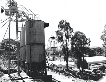
... Goldfields. The mine site has retained evidence of its development since 1937 with its most recent periods of equipment upgrades in the 1950s and 1980s being documented by buildings, structures and intact and working machinery. ...Goldfields. The mine site has retained evidence of its development since 1937 with its most recent periods of equipment upgrades in the 1950s and 1980s being documented by buildings, structures and intact and working machinery. ...Wattle Gully Mine holds a pivotal position in the history of the State's quartz mining industry. The rich strike at Wattle Gully mine in 1937 helped revive the State's gold mining industry that had been in the doldrums since the First World War. Wattle Gully, and a handful of other 'new' companies - the Maude and Yellow Girl, Morning Star, A 1, and North Deborah - were the flagships of the revived industry and sustained the State's gold production for some 30 years. Wattle Gully mine, with a yield of 350,000 ounces, was the richest mine of its era. By 1940, the Wattle Gully Company had paid out £207,000 in dividends to its shareholders. The company continued to mine profitably through the Second World War, though it struggled due to a shortage of manpower. After the war, the mine continued to develop - in the early 1950s new plant including a winding engine, steel poppet head, and twenty-head battery was added. The plant was obtained from the Central Nell Gwynne Company, Bendigo. On 13 March 1969, the Wattle Gully Company closed down the mine, laying off 62 men. Since 1970 Wattle Gully mine has worked intermittently. Recent additions to the mine's infrastructure has been a new ore processing plant and a decline tunnel. The ore processing plant was operated by Newmont mining from 1987 to 1990 and subsequently operated by Consolidated Victorian Mines and Duketon Goldfields. The mine site has retained evidence of its development since 1937 with its most recent periods of equipment upgrades in the 1950s and 1980s being documented by buildings, structures and intact and working machinery. Heritage Council Victoria: https://vhd.heritagecouncil.vic.gov.au/places/2380 Black and white photograph: view of Wattle Gully mine site with ore bins, poppet head and mining sheds. Eucalypt trees in centre of image. gold mining, underground, wattle gully gold mine, chewton, ore bins, poppet head, mine sheds -
 Bendigo Historical Society Inc.
Photograph - AUSTIN COLLECTION: Wattle Gully Gold Mine, Chewton, 1980's
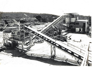
... Goldfields. The mine site has retained evidence of its development since 1937 with its most recent periods of equipment upgrades in the 1950s and 1980s being documented by buildings, structures and intact and working machinery. ...Goldfields. The mine site has retained evidence of its development since 1937 with its most recent periods of equipment upgrades in the 1950s and 1980s being documented by buildings, structures and intact and working machinery. ...Wattle Gully Mine holds a pivotal position in the history of the State's quartz mining industry. The rich strike at Wattle Gully mine in 1937 helped revive the State's gold mining industry that had been in the doldrums since the First World War. Wattle Gully, and a handful of other 'new' companies - the Maude and Yellow Girl, Morning Star, A 1, and North Deborah - were the flagships of the revived industry and sustained the State's gold production for some 30 years. Wattle Gully mine, with a yield of 350,000 ounces, was the richest mine of its era. By 1940, the Wattle Gully Company had paid out £207,000 in dividends to its shareholders. The company continued to mine profitably through the Second World War, though it struggled due to a shortage of manpower. After the war, the mine continued to develop - in the early 1950s new plant including a winding engine, steel poppet head, and twenty-head battery was added. The plant was obtained from the Central Nell Gwynne Company, Bendigo. On 13 March 1969, the Wattle Gully Company closed down the mine, laying off 62 men. Since 1970 Wattle Gully mine has worked intermittently. Recent additions to the mine's infrastructure has been a new ore processing plant and a decline tunnel. The ore processing plant was operated by Newmont mining from 1987 to 1990 and subsequently operated by Consolidated Victorian Mines and Duketon Goldfields. The mine site has retained evidence of its development since 1937 with its most recent periods of equipment upgrades in the 1950s and 1980s being documented by buildings, structures and intact and working machinery. Heritage Council Victoria: https://vhd.heritagecouncil.vic.gov.au/places/2380 Black and white photograph: view of Wattle Gully mine site with two elevators, centre of image. gold mining, underground, wattle gully gold mine, ore elevators -
 Bendigo Historical Society Inc.
Photograph - AUSTIN COLLECTION: Wattle Gully Gold Mine, Chewton, 1980's
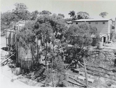
... Goldfields. The mine site has retained evidence of its development since 1937 with its most recent periods of equipment upgrades in the 1950s and 1980s being documented by buildings, structures and intact and working machinery. ...Goldfields. The mine site has retained evidence of its development since 1937 with its most recent periods of equipment upgrades in the 1950s and 1980s being documented by buildings, structures and intact and working machinery. ...Wattle Gully Mine holds a pivotal position in the history of the State's quartz mining industry. The rich strike at Wattle Gully mine in 1937 helped revive the State's gold mining industry that had been in the doldrums since the First World War. Wattle Gully, and a handful of other 'new' companies - the Maude and Yellow Girl, Morning Star, A 1, and North Deborah - were the flagships of the revived industry and sustained the State's gold production for some 30 years. Wattle Gully mine, with a yield of 350,000 ounces, was the richest mine of its era. By 1940, the Wattle Gully Company had paid out £207,000 in dividends to its shareholders. The company continued to mine profitably through the Second World War, though it struggled due to a shortage of manpower. After the war, the mine continued to develop - in the early 1950s new plant including a winding engine, steel poppet head, and twenty-head battery was added. The plant was obtained from the Central Nell Gwynne Company, Bendigo. On 13 March 1969, the Wattle Gully Company closed down the mine, laying off 62 men. Since 1970 Wattle Gully mine has worked intermittently. Recent additions to the mine's infrastructure has been a new ore processing plant and a decline tunnel. The ore processing plant was operated by Newmont mining from 1987 to 1990 and subsequently operated by Consolidated Victorian Mines and Duketon Goldfields. The mine site has retained evidence of its development since 1937 with its most recent periods of equipment upgrades in the 1950s and 1980s being documented by buildings, structures and intact and working machinery. Heritage Council Victoria: https://vhd.heritagecouncil.vic.gov.au/places/2380 Black and white photograph: landscape view of Wattle Gully mine site. Eucalypt trees in foreground, mining sheds in background. Ore bins on left hand side of image.gold mining, underground, wattle gully gold mine, mine sheds, ore bins -
 Bendigo Historical Society Inc.
Photograph - AUSTIN COLLECTION: Bill Williamson, 1980's
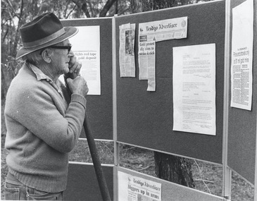
... Goldfields. The mine site has retained evidence of its development since 1937 with its most recent periods of equipment upgrades in the 1950s and 1980s being documented by buildings, structures and intact and working machinery. ...Goldfields. The mine site has retained evidence of its development since 1937 with its most recent periods of equipment upgrades in the 1950s and 1980s being documented by buildings, structures and intact and working machinery. ...Wattle Gully Mine holds a pivotal position in the history of the State's quartz mining industry. The rich strike at Wattle Gully mine in 1937 helped revive the State's gold mining industry that had been in the doldrums since the First World War. Wattle Gully, and a handful of other 'new' companies - the Maude and Yellow Girl, Morning Star, A 1, and North Deborah - were the flagships of the revived industry and sustained the State's gold production for some 30 years. Wattle Gully mine, with a yield of 350,000 ounces, was the richest mine of its era. By 1940, the Wattle Gully Company had paid out £207,000 in dividends to its shareholders. The company continued to mine profitably through the Second World War, though it struggled due to a shortage of manpower. After the war, the mine continued to develop - in the early 1950s new plant including a winding engine, steel poppet head, and twenty-head battery was added. The plant was obtained from the Central Nell Gwynne Company, Bendigo. On 13 March 1969, the Wattle Gully Company closed down the mine, laying off 62 men. Since 1970 Wattle Gully mine has worked intermittently. Recent additions to the mine's infrastructure has been a new ore processing plant and a decline tunnel. The ore processing plant was operated by Newmont mining from 1987 to 1990 and subsequently operated by Consolidated Victorian Mines and Duketon Goldfields. The mine site has retained evidence of its development since 1937 with its most recent periods of equipment upgrades in the 1950s and 1980s being documented by buildings, structures and intact and working machinery. Heritage Council Victoria: https://vhd.heritagecouncil.vic.gov.au/places/2380 Black and white photograph: former miner from Castlemaine, Bill Williamson, leaning on a shovel, reading newspaper clippings pinned on trifold noticeboard. One notice ' Bendigo Advertiser, 'Gold protest dig aims to strike it rich'. Photo probably taken near Chewton.Written on back of photo in blue pen: Bill Williamson, old miner from Castlemaine, (mined through depression yrs) gold mining, underground, wattle gully gold mine, mine sheds, ore bins -
Bendigo Historical Society Inc.
Document - National Trust Collection: Heritage Bid For Central Victorian Goldfields, 1981
... Goldfields and the official launch of the Central Nell Gwynne Poppet Legs Restoration The Central Nell Gwynne Mine operated from 1906 to 1950, reaching a depth of 1,912 feet and yielding 61,884 ounces of gold (approx. $25 million at current prices). The mine was one of the finest on the Bendigo field, with notable engineering features such as tubular steel lattice poppet legs and extensive mining equipment, much of which remains visible on site.Goals are to Stabilize the existing structure, Fabricate internal supports for the poppet legs and winding wheels, Restore original paint colors and install flood lighting. ...Goldfields and the official launch of the Central Nell Gwynne Poppet Legs Restoration The Central Nell Gwynne Mine operated from 1906 to 1950, reaching a depth of 1,912 feet and yielding 61,884 ounces of gold (approx. $25 million at current prices). The mine was one of the finest on the Bendigo field, with notable engineering features such as tubular steel lattice poppet legs and extensive mining equipment, much of which remains visible on site.Goals are to Stabilize the existing structure, Fabricate internal supports for the poppet legs and winding wheels, Restore original paint colors and install flood lighting. ...In November 1981 the City of Bendigo sent out an official invitation and informational outline for two significant events in Bendigo; the Public launch of the World Heritage Bid for the Central Victorian Goldfields and the official launch of the Central Nell Gwynne Poppet Legs Restoration The Central Nell Gwynne Mine operated from 1906 to 1950, reaching a depth of 1,912 feet and yielding 61,884 ounces of gold (approx. $25 million at current prices). The mine was one of the finest on the Bendigo field, with notable engineering features such as tubular steel lattice poppet legs and extensive mining equipment, much of which remains visible on site.Goals are to Stabilize the existing structure, Fabricate internal supports for the poppet legs and winding wheels, Restore original paint colors and install flood lighting. Estimated Cost was $55,000.Project, Team:Supervision: Kurt Bruhn (City Engineer), Colin Campbell Contractor: AllWeld Bendigo; Heritage Consultant: Andrew Ward,Engineering Consultant: Howard Osborne, Project Coordinator: Norm Cameron The restoration was funded by a loan from the Central Goldfields Restoration Fund, as part of a Commonwealth/State Bicentennial Project through the Ministry for Planning and Environment.Invitation to Public Launch, Programme for the launch, Burra Charter - International Charter for the Conservation and Restoration of Monuments and sites, Building included in the initial Register. This item contains the following documents: 3084.51a Invitation from the City of Bendigo to attend the Bendigo Bid for World Heritage of the Goldfields; and the launch of the Central Nell Gwynne Poppet Legs Restoration Project 9th Nov 1989 3084.51b Letters in 1974 from the Natrional Trust. The Bendigo City Council requested a list of historic buildings requiring urgent maintenance to support applications for Australian Government renovation funding and potential inclusion in the Historic Buildings Register. 3084.51c 1981 International Charter for the Restoration of Monuments and Sites (Venice 1966), and the Resolutions of the 5th General Assembly of ICOMOS (Moscow 1978) known as The Burra Charterhistory, national trust bendigo collection, bendigo, central goldfields, nell gwynne mine, north virginia mine -
 Bendigo Historical Society Inc.
Slide - DIGGERS & MINING. THE DIGGINGS THE DIGGERS, c1853
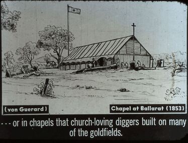
... goldfields. (von Guerard) Chapel at Ballarat (1853). The church of wooden structure with a wooden cross on one end of the gable roof and a flag pole at the other end of the building flying a flag with a cross. ...goldfields. (von Guerard) Chapel at Ballarat (1853). The church of wooden structure with a wooden cross on one end of the gable roof and a flag pole at the other end of the building flying a flag with a cross. ...Diggers & Mining. The Diggings The Diggers. Slide: or in chapels that church-loving diggers built on many of the goldfields. (von Guerard) Chapel at Ballarat (1853). The church of wooden structure with a wooden cross on one end of the gable roof and a flag pole at the other end of the building flying a flag with a cross. Markings: 73 994.LIF:4. Used as a teaching aid.hanimounteducation, tertiary, goldfields -
 Bendigo Historical Society Inc.
Slide - DIGGERS & MINING. THE GOLD LICENCE, c1850s
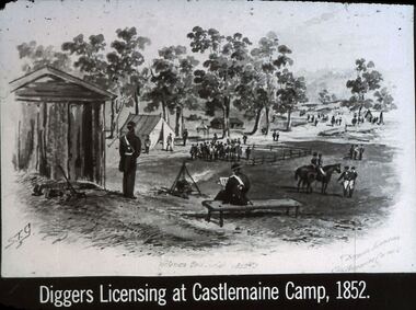
... goldfields hanimount Diggers & Mining. The gold licence. The Government Camp. Slide: Diggers Licensing at Castlemaine Camp, 1852. Slide shows sketch by STG, has wooden structure ...Diggers & Mining. The gold licence. The Government Camp. Slide: Diggers Licensing at Castlemaine Camp, 1852. Slide shows sketch by STG, has wooden structure for Commissioner, tent in background for miner, and miners. The Commissioner and his men are also in the picture. Markings: 12 994.LIF. 4. Used as a teaching aid.hanimounteducation, tertiary, goldfields -
 Bendigo Historical Society Inc.
Document - Kangaroo Flat Gold Mine Collection: Psychology of Mine Development on Bendigo Goldfield, 19th century, Bendigo Mining NL, Unknown
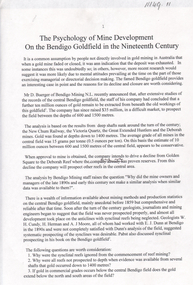
... goldfield had a 'further ten million ounces of gold' remaining 'to be extracted from beneath the old workings'. Further paragraphs include: 1. Non-development of the synclinal reefs 2. Mining methods 3. Deep mining 4. The age of the owners and managers 5. Capital raising 6. Attitude to innovation - reference to George Lansell and Gustave Thureau 7. Management structures...goldfield had a 'further ten million ounces of gold' remaining 'to be extracted from beneath the old workings'. Further paragraphs include: 1. Non-development of the synclinal reefs 2. Mining methods 3. Deep mining 4. The age of the owners and managers 5. Capital raising 6. Attitude to innovation - reference to George Lansell and Gustave Thureau 7. Management structures ...Eleven page paper titled 'The Psychology of Mine Development on the Bendigo goldfield in the nineteenth century'. Initial discussion refers to Mr. Doug Buerger of Bendigo Mining N.L commenting that the central Bendigo goldfield had a 'further ten million ounces of gold' remaining 'to be extracted from beneath the old workings'. Further paragraphs include: 1. Non-development of the synclinal reefs 2. Mining methods 3. Deep mining 4. The age of the owners and managers 5. Capital raising 6. Attitude to innovation - reference to George Lansell and Gustave Thureau 7. Management structures 8. Attitudes to machinery 9. The size of claims and leases 10. Conclusionsbendigo mining n.l., bendigo, mining, gold, kangaroo flat, 1. non-development of the synclinal reefs, 2. mining methods, 3. deep mining, 4. the age of the owners and managers, 5. capital raising, 7. management structures, 8. attitudes to machinery, 9. the size of claims and leases, 10 conclusions, doug buerger, gustave thureau, quartz mining, synclinal reefs, new chum railway, victoria quartz, great extended hustlers, deborah mines, innovation -
 Bendigo Historical Society Inc.
Document - Kangaroo Flat Gold Mine Collection: Role of Council in mining proposals, Unknown
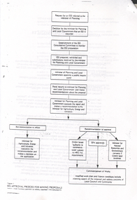
... Bendigo Mining NL website: https://www.bmnl.com.au/goldfield-history/ Mining proposals: Applications for a new mineral tenement must be accompanied by a mining proposal. The proposal and additional prescribed information enable a structured assessment of the environmental impacts associated with the proposed operations. ...Bendigo Mining NL website: https://www.bmnl.com.au/goldfield-history/ Mining proposals: Applications for a new mineral tenement must be accompanied by a mining proposal. The proposal and additional prescribed information enable a structured assessment of the environmental impacts associated with the proposed operations. ...Bendigo Mining 1993 to present In the 1980s Bendigo Mining listed on the ASX with ownership of leases along the Deborah line of reef. In 1993, the Company consolidated ownership of the entire Goldfield when it purchased WMC’s interests. A detailed account of the recent history of Bendigo Mining is outlined in the Company History. Bendigo Mining NL website: https://www.bmnl.com.au/goldfield-history/ Mining proposals: Applications for a new mineral tenement must be accompanied by a mining proposal. The proposal and additional prescribed information enable a structured assessment of the environmental impacts associated with the proposed operations. This assessment will consider the environmental setting and the views of stakeholders and individuals or groups with an interest in the project. The proposal is also the applicant’s opportunity to describe the potential benefits of the operation, which will contribute to the assessment of the appropriateness of the proposed environmental outcomes. https://energymining.sa.gov.au/industry/minerals-and-mining/mining/establish-a-mine-or-quarry/mining-proposal-and-management-plansTwo page, double sided document titled 'Assessment of Mining Projects, Role of Council'. The approvals process and the role of Council are discussed in the paper. A flow chart on page two provides a graphic example of the approval process for mining proposals. bendigo mining n.l., bendigo, mining, gold, approvals process, bendigo council, environmental effects statement, minister for mining, local government, mining proposal, tenement
