Showing 5 items matching "suburban commercial development"
-
 Broadmeadows Historical Society & Museum
Document - Correspondence, S. Gore, City Engineer, Guidelines for the Future Planning of the Glenroy Shopping Centre and Environs, 24 July 1979
... ...Suburban commercial development...suburban growth and wider Victorian planning reform. This letter is significant as evidence of late 1970s municipal planning in Glenroy, illustrating the City of Broadmeadows’ role in working with local traders to shape the development of a major suburban shopping centre during a period of growth and changing planning controls. Glenroy Shopping Centre Urban planning Local government Suburban commercial ...This item documents late 1970s City of Broadmeadows planning activities, showing local government engagement with traders over the rezoning, transport planning, and structured redevelopment of the Glenroy Shopping Centre during a period of suburban growth and wider Victorian planning reform.This letter is significant as evidence of late 1970s municipal planning in Glenroy, illustrating the City of Broadmeadows’ role in working with local traders to shape the development of a major suburban shopping centre during a period of growth and changing planning controls.One typed letter on City of Broadmeadows letterhead; black ink on white paper.“SG:JG.345” (top of first page) / “24th July, 1979” (letter body)glenroy shopping centre, urban planning, local government, suburban commercial development, city of broadmeadows, zoning and infrastructure planning, community consultation, melbourne northern suburbs -
 Ringwood and District Historical Society
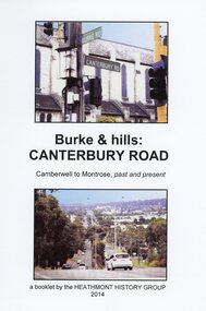
Book, Burke & Hills: Canterbury Road Camberwell to Montrose, by Heathmont History Group - 2014
... Grand homes and churches at one end, major and minor shopping centres along the 25km, factories now where farms were, big box stores, fast food outlets, train stations, resrvoir, traffic, residential stretches, modern apartment blocks, parklands, child-minding centres, sporting ovals, a sewage farm, hotels, quarries, commercial developments, plant nurseries, a golf course, bridges, memorials, Asian food shops, telecommunication towers, bushland, creeks, crossroads, traffic lights, mansions, orchards, swamps ... Delaneys Road, renamed Canterbury Road after a 19th century Victorian Governor, is a fascinating study in land use and history as suburban Melbourne has continually diversified and pushed outwards. ...Grand homes and churches at one end, major and minor shopping centres along the 25km, factories now where farms were, big box stores, fast food outlets, train stations, resrvoir, traffic, residential stretches, modern apartment blocks, parklands, child-minding centres, sporting ovals, a sewage farm, hotels, quarries, commercial developments, plant nurseries, a golf course, bridges, memorials, Asian food shops, telecommunication towers, bushland, creeks, crossroads, traffic lights, mansions, orchards, swamps ... Delaneys Road, renamed Canterbury Road after a 19th century Victorian Governor, is a fascinating study in land use and history as suburban Melbourne has continually diversified and pushed outwards. ...Soft cover book of 40 pages with spiral wire spine. Compilation of images and descriptive timeline of the geology, geography and European settlement history of Canterbury Road.Soon after beginning at Burke Road Camberwell, Canterbury Road moves into the gentle hills of Canterbury, then on to Surrey Hills, Box Hill and Forest Hill. Further along past these three "hills" come three "monts" - Vermont, Heathmont and at its other end, Montrose, by then in the foothills of the Dandenongs. Grand homes and churches at one end, major and minor shopping centres along the 25km, factories now where farms were, big box stores, fast food outlets, train stations, resrvoir, traffic, residential stretches, modern apartment blocks, parklands, child-minding centres, sporting ovals, a sewage farm, hotels, quarries, commercial developments, plant nurseries, a golf course, bridges, memorials, Asian food shops, telecommunication towers, bushland, creeks, crossroads, traffic lights, mansions, orchards, swamps ... Delaneys Road, renamed Canterbury Road after a 19th century Victorian Governor, is a fascinating study in land use and history as suburban Melbourne has continually diversified and pushed outwards. Compiled by Heathmont History Group, Rita James, Les Prato, Betty Colbert, Jeff Leipold, Gerry Robinson (convenor). -
Broadmeadows Historical Society & Museum
Photograph - Aerial Photograph
... commercial developments reshaping the landscape. Key historical milestones include: Early Settlement: Originally inhabited by the Wurundjeri people of the Kulin Nation. European Settlement: Began in the mid-1800s, primarily for farming and grazing. Urban Expansion: Post-1970s, Craigieburn saw increasing suburban...commercial developments reshaping the landscape. Key historical milestones include: Early Settlement: Originally inhabited by the Wurundjeri people of the Kulin Nation. European Settlement: Began in the mid-1800s, primarily for farming and grazing. Urban Expansion: Post-1970s, Craigieburn saw increasing suburban ...Craigieburn is a rapidly growing suburb located approximately 25 km north of Melbourne’s CBD. Historically, it was a rural area with agricultural roots, but since the late 20th century, it has undergone significant urban development. The transformation accelerated in the 1990s and 2000s, with large-scale residential subdivisions, infrastructure projects, and commercial developments reshaping the landscape. Key historical milestones include: Early Settlement: Originally inhabited by the Wurundjeri people of the Kulin Nation. European Settlement: Began in the mid-1800s, primarily for farming and grazing. Urban Expansion: Post-1970s, Craigieburn saw increasing suburban development, especially after the extension of rail and road infrastructure. Recent Growth: From the 2000s onward, Craigieburn became one of Melbourne’s fastest-growing suburbs, with new estates, schools, and shopping centres.This large colour aerial photograph of Craigieburn holds significant value as a visual record of the suburb’s transformation from a semi-rural landscape to a dynamic urban centre in Melbourne’s northern growth corridor. Captured during a period of rapid development, the image documents the spatial evolution of Craigieburn, including residential expansion, infrastructure projects, and the integration of green spaces and commercial zones. The photograph is historically significant as it reflects the broader patterns of post-2000 suburban growth in Victoria, driven by population pressures, housing demand, and strategic planning initiatives. It provides insight into land use changes, transport connectivity (notably the Hume Highway and Craigieburn railway line), and the emergence of community hubs such as Craigieburn Central. From a cultural heritage perspective, the image contributes to understanding the lived environment of diverse communities who have settled in Craigieburn, including its role in accommodating Melbourne’s multicultural population. It also serves as a reference point for future urban planning, environmental monitoring, and historical comparison. The photograph is an important archival asset for researchers, planners, and local historians, offering a detailed snapshot of a pivotal moment in Craigieburn’s development trajectory.Colour aerial photograph of Craigieburnaerial photograph, craigieburn -
![Victorian era cottage, Derby Street [Kew]](/media/collectors/550653872162f11fb04854aa/items/658f5772101c4283c6ae47ff/item-media/658f57e4101c4283c6ae493a/item-fit-380x285.jpg?cb=6) Kew Historical Society Inc
Kew Historical Society IncPhotograph - Victorian era cottage, Derby Street [Kew], c. 1965
... commercial development. This work forms part of the collection assembled by the historian Dorothy Rogers (1905-1973), donated to the Kew Historical Society by her son in 2015. The manuscripts, photographs, maps, and documents were sourced by her from both family and local collections or produced as references for her print publications. Many were directly used by Rogers in writing ‘Lovely Old Homes of Kew’ (1961) and 'A History of Kew' (1973), or the numerous articles on local history that she produced for suburban ...The current site of the Kew Recreation Centre in High Street Kew previously housed the Kew Depot on the corner of Disraeli Street. In nearby Derby Street, a number of original Victorian era buildings were gradually replaced due to development of the Baths precinct and commercial development.This work forms part of the collection assembled by the historian Dorothy Rogers (1905-1973), donated to the Kew Historical Society by her son in 2015. The manuscripts, photographs, maps, and documents were sourced by her from both family and local collections or produced as references for her print publications. Many were directly used by Rogers in writing ‘Lovely Old Homes of Kew’ (1961) and 'A History of Kew' (1973), or the numerous articles on local history that she produced for suburban newspapers. Most of the photographs in the collection include detailed annotations in her hand. The Rogers Collection provides a comprehensive insight into the working habits of a historian from the 1960s to the 1970s. Small single fronted cottage in Derby Street, Kew. The weatherboard cottage has a block fronted facade, and a Victorian verandah with cast iron lace.Annotation verso: "House in Derby St., next to Kew Baths (Demolished?)"dorothy rogers, derby street (kew), victorian houses -- kew (vic.) -
![Victorian era cottage, Derby Street [Kew]](/media/collectors/550653872162f11fb04854aa/items/658f7ef19239cf6fd436d1fd/item-media/658f7f019239cf6fd436d25f/item-fit-380x285.jpg?cb=6) Kew Historical Society Inc
Kew Historical Society IncPhotograph - Victorian era cottage, Derby Street [Kew], c. 1965
... commercial development. This work forms part of the collection assembled by the historian Dorothy Rogers (1905-1973), donated to the Kew Historical Society by her son in 2015. The manuscripts, photographs, maps, and documents were sourced by her from both family and local collections or produced as references for her print publications. Many were directly used by Rogers in writing ‘Lovely Old Homes of Kew’ (1961) and 'A History of Kew' (1973), or the numerous articles on local history that she produced for suburban ...The current site of the Kew Recreation Centre in High Street Kew previously housed the Kew Depot on the corner of Disraeli Street. In nearby Derby Street, a number of original Victorian era buildings were gradually replaced due to development of the Baths precinct and commercial development.This work forms part of the collection assembled by the historian Dorothy Rogers (1905-1973), donated to the Kew Historical Society by her son in 2015. The manuscripts, photographs, maps, and documents were sourced by her from both family and local collections or produced as references for her print publications. Many were directly used by Rogers in writing ‘Lovely Old Homes of Kew’ (1961) and 'A History of Kew' (1973), or the numerous articles on local history that she produced for suburban newspapers. Most of the photographs in the collection include detailed annotations in her hand. The Rogers Collection provides a comprehensive insight into the working habits of a historian from the 1960s to the 1970s. Small single fronted cottage in Derby Street, Kew. The weatherboard cottage has a block fronted facade, and a Victorian verandah with cast iron lace.dorothy rogers, derby street (kew), victorian houses -- kew (vic.)