Showing 349 items matching "surface hill"
-
 Linton and District Historical Society Inc
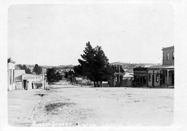
Photograph, Sussex Street, Linton, view to south, before 1912
... ... Surface Hill Hotel...The photograph is undated but was probably taken before 1912, as the Surface Hill Hotel was closed and demolished around this time....Sepia postcard photograph which shows the Surface Hill Hotel and Ching's Produce Store on the right, and O'Sullivan's saddlery and G G Bennett's butcher's shop on the left....Sussex Street Linton Buildings Shops Surface Hill Hotel R. Ching Grocer and Produce Merchant O'Sullivan's Saddlery G G Bennett butcher's shop Sepia postcard photograph which shows the Surface Hill Hotel and Ching's Produce Store on the right, and O'Sullivan's saddlery and G G Bennett's butcher's shop on the left. ...The photograph is undated but was probably taken before 1912, as the Surface Hill Hotel was closed and demolished around this time.Sepia postcard photograph which shows the Surface Hill Hotel and Ching's Produce Store on the right, and O'Sullivan's saddlery and G G Bennett's butcher's shop on the left.sussex street linton, buildings, shops, surface hill hotel, r. ching grocer and produce merchant, o'sullivan's saddlery, g g bennett butcher's shop -
 Federation University Historical Collection
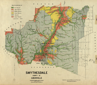
Map, Smythesdale, County of Grenville, 1888, 1889
... ...surface hill...Krause and includes information on the water reserve, worked quartz veins, Watson's Hill, Surface Hill and Sugarloaf Hill, Haddon, Trunk Lead and the Crucible Shaft. ...This land was printed form the Crown Lands Department, Melbourne. smythesdale krause f.m. krause ferdinand krause nitingbool watson's hill surface hill sugarloaf hill haddon Coloured map of the County of Grenville. ...The map maker, Ferdinand M. Krause, was a professor at the Ballarat School of Mines. This land was printed form the Crown Lands Department, Melbourne. Coloured map of the County of Grenville. The edge has been taped. The scale is 40 chains to 1 inch. The map is accompanied with a foolscap sheet printed by the Mines Department in 1898. It is a Report on the Parish of Smythesdale by F.M. Krause and includes information on the water reserve, worked quartz veins, Watson's Hill, Surface Hill and Sugarloaf Hill, Haddon, Trunk Lead and the Crucible Shaft. smythesdale, krause, f.m. krause, ferdinand krause, nitingbool, watson's hill, surface hill, sugarloaf hill, haddon -
 Bendigo Historical Society Inc.
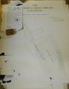
Document - MARKS COLLECTION: PLAN RELATING TO UNDERGROUND AND SURFACE WORKINGS VICTORIA HILL
... MARKS COLLECTION: PLAN RELATING TO UNDERGROUND AND SURFACE WORKINGS VICTORIA HILL...Plan on paper: on top of plan 'plan showing the position of the underground & surface workings in the claim of Mr. Ballerstedt Victoria Hill' Signed by Thomas Forbes, Mining Surveyor, 22nd. ...I may state that I have inspected the underground workings generally in the mine, and the timbering is of the most substantial character Document MARKS COLLECTION: PLAN RELATING TO UNDERGROUND AND SURFACE WORKINGS VICTORIA HILL ...Plan on paper: on top of plan 'plan showing the position of the underground & surface workings in the claim of Mr. Ballerstedt Victoria Hill' Signed by Thomas Forbes, Mining Surveyor, 22nd. April 1868' Attached to plan is a letter report accompanying plans on the underground workings in (illegible) Ballerstedt & Sons, Victoria Hill (ink blot covering writing RH side) Text of letter begins : the underground level southwards from the shaft is 4ft 6' x 6 ft wide as shown on the plan; and is at a depth of (illegible) from the surface; along the (illegible) of which the timbering both upright and cap-pieces; are now in as good condition as when the work was being proceed with; with the exception of the uprights and one cap-piece which are slightly crushed from the general settlement of the mullock. The timbering of the drives is still standing in the same position though upwards of 12 months has elapsed after the slip in the open cutting had taken place, showing very clearly in my mind that the slip could not be attributable to the insufficient timbering of the underground workings; but rather to the action of the weather in this particular part of the cutting. The probably quantity of mullock that was detached or slipped from the west side of the cutting; would be (from careful enquiry and observation ) about 1500 loads at least; enough to crush the whole of the timber in the levels, if it had not been of the most substantial character and I think yours to prove that the fall was not caused by any defective timbering but from the cause already stated. I may state that I have inspected the underground workings generally in the mine, and the timbering is of the most substantial characterbendigo, mining, victoria hill -
 Linton and District Historical Society Inc
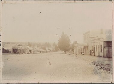
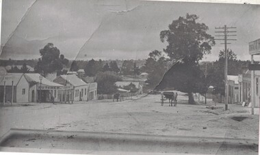
Photograph, Sussex Street, Linton, View to south-west, circa 1900
... ... Surface Hill Hotel...On the right, the buildings are E H Nicholls ("cheap grocer and seedsman"), the Surface Hill Hotel, Richard Ching's store and dwelling (grocer & produce merchant), and another shop without verandah (probably shop and dwelling owned by Annie Brown, née Nicholls)....On the right, the buildings are E H Nicholls ("cheap grocer and seedsman"), the Surface Hill Hotel, Richard Ching's store and dwelling (grocer & produce merchant), and another shop without verandah (probably shop and dwelling owned by Annie Brown, née Nicholls). ...Shops on the left of the picture are: Patrick O'Sullivan saddler, G. G. Bennett butcher , Nicol's bakery, Wises drapery 'Ellington House' (shop with verandah just past bakery, Preston's shop (with verandah, on corner of Sussex & Gillespie Streets), and Wishart's blacksmiths (on the far side of Gillespie Street). On the right, the buildings are E H Nicholls ("cheap grocer and seedsman"), the Surface Hill Hotel, Richard Ching's store and dwelling (grocer & produce merchant), and another shop without verandah (probably shop and dwelling owned by Annie Brown, née Nicholls).Original black and white photograph affixed to white backing paper which has then been mounted on grey card. The photograph shows the view along Sussex Street to the south-west. Two men are standing outside a shop on the rhs, and there appears to be a woman with a perambulator outside a building further along the street on the rhs.On back of original photograph: "g (or e) Bennett" (in blue pencil or chalk) / "LINTON STREET "(in ink) / "Elizabeth long ago" (in ink, with arrow pointing to blue writing).sussex street linton, o'sullivan's saddlery, g g bennett's butcher shop, nicol's bakery, ellington house [t m wise draper], preston's shop, wishart's blacksmiths, e h nicholls' store, surface hill hotel, richard ching's store, annie brown's shop, annie brown (née nicholls) -
 Linton and District Historical Society Inc
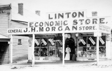
Photograph, J. H. Morgan Store, Linton
... The photo shows part of the Surface Hill Hotel on the left....The photo shows part of the Surface Hill Hotel on the left. J. H. Morgan Store, Linton Photograph ...Black and white copy of a photograph showing a man standing in the doorway of Morgan's Store when it was run by JH Morgan. The photo shows part of the Surface Hill Hotel on the left.linton economic store, morgan's store, j.h. morgan -
 Linton and District Historical Society Inc
Family File, Robert Charles Miller Family File
... Miller was a dispensing chemist with premises on Surface Hill, Linton (Sussex Street)....Miller was a dispensing chemist with premises on Surface Hill, Linton (Sussex Street). Robert Charles Miller Linton Chemists File contains information and correspondence dated from 2018, relating to Robert Charles Miller and family. ...R. C. Miller was a dispensing chemist with premises on Surface Hill, Linton (Sussex Street).File contains information and correspondence dated from 2018, relating to Robert Charles Miller and family.robert charles miller, linton, chemists -
 Linton and District Historical Society Inc
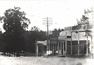
Photograph, Sussex Street, Linton, showing shops on east and west of street, undated (early 1900s?)
... The photograph can be dated to after 1911, as the Surface Hill hotel (between Morgan and Ching stores) appears to have already been demolished (this happened in 1911)....Linton and District Historical Society Inc 69 Sussex Street Linton 3360 goldfields The photograph can be dated to after 1911, as the Surface Hill hotel (between Morgan and Ching stores) appears to have already been demolished (this happened in 1911). ...The photograph can be dated to after 1911, as the Surface Hill hotel (between Morgan and Ching stores) appears to have already been demolished (this happened in 1911).Black and white copy of original photograph, which shows east and west sides of Sussex Street, from Morgan's store to Gillespie Street. On the left of the photo (east side of street), there is a glimpse of Patrick O'Sullivan's saddlery shop, then G. G. Bennett's butcher's shop, Nicol's bakery, Wise's drapery, and further along the street the verandah of Preston's store can be seen. On the west side, there is a glimpse of J. H. Morgan's grocery store, Ching's produce store, and Annie Brown's newsagency (Annie Brown nee Annie Nicholls). Two horse-drawn vehicles are in the street. There is a telegraph pole near Morgan's shop.sussex street linton, g.g. bennett bucher's shop, nicol's bakery, wise's drapery, j h morgan grocery store, ching's produce store, annie brown's newsagency -
 Linton and District Historical Society Inc
Photograph, Shops in Sussex Street, Linton, circa 1922
... What appears to be a laneway between the Morgan shop and the Ching dwelling was once occupied by the Surface Hill Hotel (demolished c.1911). Shops in Sussex Street, Linton, c.1922: Morgan's, Ching's, Brown's. ...What appears to be a laneway between the Morgan shop and the Ching dwelling was once occupied by the Surface Hill Hotel (demolished c.1911). Shops in Sussex Street, Linton, c.1922: Morgan's, Ching's, Brown's. ...Black and white copy of original photograph which shows the shop in Sussex Street owned by J. H. Morgan, the shop and dwelling owned by Richard Ching (telegraph pole in front), and the shop and dwelling owned by Annie Brown (née Nicholls). A small building between Ching's and Brown's shops may be the workshop of Dan McMillan, bootmaker. What appears to be a laneway between the Morgan shop and the Ching dwelling was once occupied by the Surface Hill Hotel (demolished c.1911). Shops in Sussex Street, Linton, c.1922: Morgan's, Ching's, Brown's. The original Bank of New South Wales building (by 1922 a private residence owned by the Lewers family) can just be seen further along the street, screened by a large tree.On reverse:"J. H. Morgans store Sussex St Linton c.1922".annie brown (née nicholls), j.h. morgan, richard ching, dan mcmillan -
 Bendigo Historical Society Inc.
Document - LONG GULLY HISTORY GROUP COLLECTION: HAPPY VALLEY ROAD
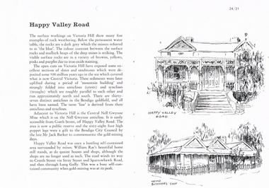
... Describes surface workings on Victoria Hill and the different colours of the rocks, the formation of the anticlines and the synclines which are roughly parallel and run approximately north and south. ...History House 11 Mackenzie Street Bendigo goldfields BENDIGO History long gully history group The Long Gully History Group - Happy Valley Road Victoria Hill Central Nell Gwynne Mine Bendigo City Council Mr Jack Barker William Rae Heinz Butcher's Shop Titled Happy Valley Road. Describes surface ...Titled Happy Valley Road. Describes surface workings on Victoria Hill and the different colours of the rocks, the formation of the anticlines and the synclines which are roughly parallel and run approximately north and south. They are all named and make the lines on the Bendigo Goldfield. Adjacent to Victoria Hill is the Central Nell Gwynne Mine which is on the Nell Gwynne anticline. There were quaint houses and shops in Happy Valley Road, although the shops are no longer used as such. On the right are two sketches, one an old house and below it is Heinz Butcher's Shop.bendigo, history, long gully history group, the long gully history group - happy valley road, victoria hill, central nell gwynne mine, bendigo city council, mr jack barker, william rae, heinz butcher's shop -
 Bendigo Historical Society Inc.
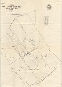
Map - GREAT EXTENDED HUSTLER'S MINE - PLAN OF THE GREAT EXTENDED HUSTLER'S MINE
... Mine was located in the block bounded by Langston and Anderson Streets and was between the Hustler's Anticline at Surface and the Lightning Hill Anticline at Surface. Latham & Watson's Shaft is also mentioned. ...Mine was located in the block bounded by Langston and Anderson Streets and was between the Hustler's Anticline at Surface and the Lightning Hill Anticline at Surface. Latham & Watson's Shaft is also mentioned. ...Plan of the Great Extended Hustler's Mine on the Hustler's Line of Reefs, Bendigo. Bulletin No 33, Plate No X. Lease No 7382. Plan has map of streets. Mine was located in the block bounded by Langston and Anderson Streets and was between the Hustler's Anticline at Surface and the Lightning Hill Anticline at Surface. Latham & Watson's Shaft is also mentioned. Levels are numbered and a table shows the Levels and their Depths. Geological Survey of Victoria. Signed by H A Whitelaw, Underground Survey Office, Bendigo, September 1913. This item has not been scanned or photographed.mining, parish map, great extended hustler's mine, hustler's line of reefs, mining lease no 7382, geological survey of victoria, underground survey office bendigo, h a whitelaw, latham & watson's shaft -
 Bendigo Historical Society Inc.
Document - POPPET LEGS AND ENGINES -WHERE SHIFTED TO
... Very hard to see which cage or tank at surface. Specimen Hill and Carlisle - Back-handed first motion engines. ...Very hard to see which cage or tank at surface. Specimen Hill and Carlisle - Back-handed first motion engines. ...Handwritten notes where poppet legs and engines were taken. New Chum Goldfields - To Golden Fleece. To Deborah. To Central Deb. Carlisle Poppet Heads - to Guilford Plateau, then to Nell Gwynne Reefs. Williams United Engine (Sq Con Reds) - To Ulster then North Blue, then Nth Deborah. Central Blue Engine, with Corliss valves, to Deborah. Windmill Hill Legs to Sebastian, then to Deborah. Big Blue Legs - to Central Deborah. (Legs) South Moon to South Virginia. (Engine) Sth Moon to South Virginia, & driver put on side of drums. Fortuna Hustlers Engine - to ? ?, then to Bird's Reef, then to Herc No 1. Then to Nth Virginia. New Oswald (Malson) Engine left at Sth Moon, not allowed to put in, as it was a loose eccentric. Unity Legs - to Herc. No 1. Then to Ironbark. Ironbark Engine - To Wattle Gully. (Converted to electric winder). 222 - Several Compressors. The fire at the Unity mine in 1907. The fire at the Garden Gully mine in 1911. The fire at the Princess Dagmar in 1913. The light on the Ellenborough flagpole. Tambour Major. Joe Sheard in diving suit. Lansell's Little 180 - Vertical engine. Driver to right side and at floor level. Lansell's bit 180 - Vertical engine. Driver on top of engine. Floor between. Lansell's Needle. - Wooden legs with crossstays reaching from top of legs to close to bottom. Winder - Single Link engine. Hard to get drivers. Confidence Extended. Koch's Pioneer. - Shaft a big angle. Central Blue - Old Sheepshead - same. Vict Catherine - Winder - one drum in front of other, shaft at such an angle. Very hard to see which cage or tank at surface. Specimen Hill and Carlisle - Back-handed first motion engines. Central Nell - Winder from Lord Nelson mine, St Arnaud - Driver behind drums. Turned valve opp. To usual to turn steam on and off.document, gold, poppet legs and engines, shifting about - poppet legs and engines, new chum goldfields, golden fleece, deborah, central deborah, carlisle, guilford plateau, nell gwynne reefs, williams united, ulster, north blue, nth deborah, central blue, windmill hill, sebastian, big blue, south moon, south virginia, fortuna hustlers, tambour major, bird's reef, herc no 1, nth virginia, new oswald (maldon), unity, ironbark, wattle gully, 222, garden gully, princess dagmar, ellenborough, joe sheard, lansell's little 180, lansell's big 180, lansell's needle, confidence extended, koch's pioneer, central blue, old sheepshead, vict catherine, specimen hill, carlisle, central nell, lord nelson mine (st arnaud) -
 Warrnambool and District Historical Society Inc.
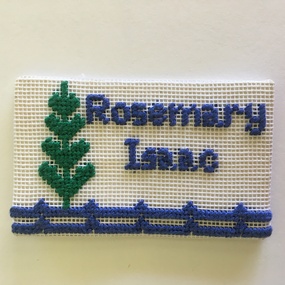
Badge, Rita Williams (designer), South Western Branch Embroiders Guild, late 20th century
... Hill Maritime Village in October 1976. This badge is kept as a memento of the work of the local Embroiderers Guild, a prominent community organization in Warrnambool and district. South Western Group of the Embroiderers Guild of Victoria ‘Rosemary Isaac’ This is a rectangular-shaped cloth badge with blue and green stitching on a white cloth surface. ...This name badge belonged to Rosemary Isaac, a member of the South Western Branch of the Embroiderers Guild of Victoria. The badge, designed by long-time member Rita Williams, shows a Norfolk Island pine tree and a fence line. The South Western Branch of the Embroiderers Guild of Victoria was formed in Warrnambool in November 1974. Its first major project was the making of a patchwork quilt for the Lighthouse Keepers cottage at Flagstaff Hill. This was presented to the Warrnambool and District Historical Society at a meeting of the Embroiderers Guild attended by Historical Society members and representatives of Flagstaff Hill Maritime Village in October 1976. This badge is kept as a memento of the work of the local Embroiderers Guild, a prominent community organization in Warrnambool and district.This is a rectangular-shaped cloth badge with blue and green stitching on a white cloth surface. ‘Rosemary Isaac’south western group of the embroiderers guild of victoria -
 Warrnambool and District Historical Society Inc.
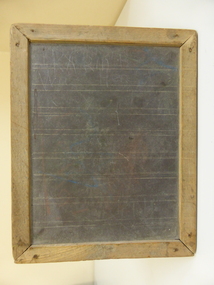
Functional object - School writing slate, Child's School Slate
... Hill, Wangoom, was a prominent cheese maker in the late 19th century and was one of the first shareholders and a member of the first Board of Directors of the Warrnambool Cheese and Butter Factory at Allansford. The dairying industry is of key importance in Warrnambool economic history. school slates educational tools of the past warrnambool history Glasgow family wangoom Scratch marks This is a child's school writing slate made from quarry slate with permanent lines for handwriting with a wooden frame. The surface ...This slate comes from the Glasgow Estate (Ellen Isabel Glasgow died in Warrnambool in 1971). It is presumed it was used by members of the Glasgow family. Slates such as this were used by all school children in Victoria (and presumably elsewhere) in the infant and younger age classes from the early days of the State until the early 1940s. It had the advantage of the work being able to be easily erased so that other work could be written. A slate pencil was used to write on this board. A more recent blackboard or chalkboard was in common use until the 1970's in junior classes. the writing with these was done with chalk.This is significant firstly as an example of past educational tools used by small children and so has important social significance as every school child of past generations would have used a slate. It is also important as it belonged to the Glasgow family. John Glasgow (c.1847-1925), at his property, Blackwood Hill, Wangoom, was a prominent cheese maker in the late 19th century and was one of the first shareholders and a member of the first Board of Directors of the Warrnambool Cheese and Butter Factory at Allansford. The dairying industry is of key importance in Warrnambool economic history.This is a child's school writing slate made from quarry slate with permanent lines for handwriting with a wooden frame. The surface is much marked and scratched. Scratch marksschool slates, educational tools of the past, warrnambool history, glasgow family wangoom -
 Bendigo Military Museum
Weapon - SHRAPNEL, BOMB PIECES, Imperial Japanese Govt, c.1937-1942
... Hill Wharf, Darwin. Pieces of bomb shrapnel from the Japanese bombing of Darwin. WW2 Aerial Bombs Shrapnel 1. Cast steel fragment approx 24mm thick. It is roughly triangular shape. It also has irregular curves. The edges are jagged and rough. 2. Cast steel fragment. Approx rectangular 24mm thick. It has irregular curves. The edges are rough and jagged. Both pieces have a rusty surface ...These two pieces were recovered during excavations at Stokes Hill Wharf, Darwin. Pieces of bomb shrapnel from the Japanese bombing of Darwin.1. Cast steel fragment approx 24mm thick. It is roughly triangular shape. It also has irregular curves. The edges are jagged and rough. 2. Cast steel fragment. Approx rectangular 24mm thick. It has irregular curves. The edges are rough and jagged. Both pieces have a rusty surface.ww2, aerial bombs, shrapnel -
 Bendigo Military Museum
Honour Board - HONOUR BOOKS, GRAVEL HILL SCHOOL, c1919 - 1946
... Hill School No. 1566. The edges of pages are "marbled". Each page is handwritten with a short biography of a soldier. There are 82 names and 10 blank pages. 3. Leather bound book. Gold embossed writing. The leather surface...Hill School No. 1566. The edges of pages are "marbled". Each page is handwritten with a short biography of a soldier. There are 82 names and 10 blank pages. 3. Leather bound book. Gold embossed writing. The leather surface ...1. Small timber cabinet with glass fronted door. Old metal handle. 2 hinges on left side. It holds two Honour rolls. 2. Leather bound book. Gold embossed writing. Gold rim around the edges - brown leather. Marked as Honor Book 1914- 19. Gravel Hill School No. 1566. The edges of pages are "marbled". Each page is handwritten with a short biography of a soldier. There are 82 names and 10 blank pages. 3. Leather bound book. Gold embossed writing. The leather surface has a dimpled appearance. The wording is: Honor Book 1939-1945 - Gravel Hill School No. 1566. There are approx 100 pages that have a service persons name stated. They have a very brief note above name.ww1, ww2, honour books, gravel hill school -
 Emerald Museum & Nobelius Heritage Park
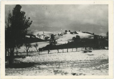
Photograph - Snow on John's Hill, 19/07/1951
... This black and white photograph looks over a snow-covered field to a hill, similarly blanketed with snow interrupted by the occasional fence or tree, rising into the cloudy sky. There are some markings and scratches in the surface of the photograph. ...Emerald 1950s Snow "Snow / Johns Hill / from [illegible] Rd 1951" This black and white photograph looks over a snow-covered field to a hill, similarly blanketed with snow interrupted by the occasional fence or tree, rising into the cloudy sky. There are some markings and scratches in the surface of the photograph. ...On Thursday the 19th of July, 1951, Melbourne faced the most snow it had seen in twenty years as the city recorded temperatures as low as 37.9 F (approximately 3 C) at 1pm - with Emerald likely facing colder conditions. Snow fell across Victoria, blanketing Emerald - and in this picture, John's Hill - in rare layers of snowfall. While there isn't data for Emerald itself, the Dandenongs had two inches of snowfall while Yea saw a foot a 3pm. It appears Emerald was between these two amounts, though it is difficult to tell from only this photograph. The smudged annotations obscure where the photograph was taken from, although it was possibly Edenmont Road.Snow of this magnitude is very rare in Emerald (as it is in most of Victoria) - an image of a very significant snowfall is important and one of only a few similar days in the past century.This black and white photograph looks over a snow-covered field to a hill, similarly blanketed with snow interrupted by the occasional fence or tree, rising into the cloudy sky. There are some markings and scratches in the surface of the photograph. Some of the pencil handwriting on the reverse is smudged, obscuring the name of the road the photograph was taken from."Snow / Johns Hill / from [illegible] Rd 1951"emerald, 1950s, snow -
 Flagstaff Hill Maritime Museum and Village
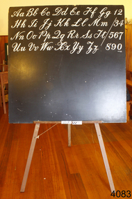
Functional object - Blackboard & Easel, Probably first half of 20th century
... surface was first used in 1930, and as this type of board became popular, the word "chalkboard" appeared. Various types of easel have been in use since ancient times, in particular for supporting paintings and other artwork. However, the schoolroom easel would have been introduced around the same time as when the blackboard started to be used in educational establishments. flagstaff hill warrnambool shipwrecked-coast flagstaff-hill flagstaff-hill-maritime-museum maritime-museum shipwreck-coast flagstaff-hill-maritime-village None Wooden board painted black, resting on wooden easel with rope supporting the three easel legs. ...The first classroom uses of large blackboards are difficult to date, but they were used for music education and composition in Europe as far back as the 16th century.The term "blackboard" is attested in English from the mid-18th century; the Oxford English Dictionary provides a citation from 1739, to write "with Chalk on a black-Board". The first attested use of chalk on blackboard in the United States dates to 1801, in a lecture course in mathematics given by George Baron. James Pillans has been credited with the invention of coloured chalk (1814); he had a recipe with ground chalk, dyes and porridge! The use of blackboards did change methods of education. Manufacturing of slate blackboards began by the 1840s. A green porcelain enamel surface was first used in 1930, and as this type of board became popular, the word "chalkboard" appeared. Various types of easel have been in use since ancient times, in particular for supporting paintings and other artwork. However, the schoolroom easel would have been introduced around the same time as when the blackboard started to be used in educational establishments. Wooden board painted black, resting on wooden easel with rope supporting the three easel legs.Noneflagstaff hill, warrnambool, shipwrecked-coast, flagstaff-hill, flagstaff-hill-maritime-museum, maritime-museum, shipwreck-coast, flagstaff-hill-maritime-village -
 Flagstaff Hill Maritime Museum and Village
Instrument - Hourglass
... This hourglass is representative of that era, which is during the time of the colonisation of Australia. flagstaff hill warrnambool shipwrecked coast flagstaff hill maritime museum maritime museum shipwreck coast flagstaff hill maritime village great ocean road horology hourglass hour glass sandglass sand glass timing instrument dead reckoning deduced reckoning finding latitude at sea sandglass with hieroglyphics and roman numerals hourglass with hieroglyphics and roman numerals brass hourglass Roman numerals on inner surface of discs " I II III IV V VI VII VIII IX X XI XII " Hieroglyphics impressed on outer surface of discs Hourglass or sandglass; an instrument used to measure time. ...An hourglass or sandglass is an instrument for measuring a defined time and can be used perpetually by simply turning it over immediately the top bulb empties. The clear blown glass is shaped into two equal sized bulbs with a narrow passage in the centre and contains uniform sized sand or glass particles in the lower bulb. The width of the neck regulates the constant flow of the particles. The glass is held in a stand with top and bottom of equal shape and size. Hourglasses can measure an infinite variety of time by gauging the size of the particles, the shape and size of the bulbs and the size of the passage between the bulbs, thus measuring hours or minutes or even seconds. Generally an hourglass sits between discs of wood at the ends, which are joined by long wooden spindles between the ends and tightened by screw caps. The length of time can be adjusted by adding or removing sand particles. The use of the marine sandglass (or hourglass) has been recorded in the 14th century in European shipping. A one minute sandglass was used in conjunction with the ship’s log for ‘dead reckoning’, (see below) that is, for measuring the ship’s speed through the water. They were also used to regulate ringing the ship’s timetable; for example a 4 hour sandglass was used for the length of the sailors’ watch, and a half hour timer for taking of readings for the ship’s log; the ship’s bell would be rung every half hour. It was usually the role of the cabin boy to watch and turn the sandglasses over at the exact time of them emptying their upper chambers and to ring the ship’s bell. Hourglasses have been used historically for many hundreds of years. Some have been used for timing church sermons, in cooking, in industry and at sea. Even today they are used for measuring the cooking time of eggs and timing a player’s turn in games such as Boggle and Pictionary. The sandglasses at sea were gradually replaced in the late 1700’s to early 1800’s by the more accurate chronometers (marine clocks) when they became reliable instruments. DEAD RECKONING (or Deduced Reckoning) Dead reckoning is the term used to describe the method of calculating the ship’s position from its speed and direction, used in early maritime travel, mostly in European waters. Both the (1) speed and the (2) direction of travel were recorded on a Traverse Board at half-hourly intervals during a helmsman’s watch of 4 hours. The navigator would record the readings in his ship’s log, plot them on his navigational chart and give his updated course directions to the next helmsman on watch, along with the cleared Traverse Board. This was a very approximate, but none-the-less helpful, method of navigation. The wooden Traverse Board was a simple pegboard with a diagram of a compass with eight peg holes along the radius to each of the compass points, plus a grid with ascending half hours in the left column and increasing ship’s speed in knots in a row across the column headings, with a peg hole in each of the intersecting cells. A number of wooden pegs were attached to strings on the board. By placing one peg consecutively in the direction’s radius hole, starting from the centre, and the speed holes when the half hourly reading was taken, a picture of speed and direction for the whole 4 hour watch was created. (1) To measure the ship’s speed a one minute hourglass timer was usually used to measure the ship’s speed through the water and help to calculate its longitude. A rope, with knots at regular standard intervals and a weight such as a log at the end, would be thrown overboard at the stern of the ship. At the same time the hourglass would be turned over and a seaman would start counting the number of knots on the rope that passed freely through his hands as the ship travelled. When the timer ran out the counting would be stopped. A timer of one minute (one-sixtieth of an hour), knots spaced one-sixtieth of a nautical mile apart, and simple arithmetic easily gave the speed of the ship in nautical miles per hour ("knots"). This would be recorded every half hour. The speed could however be inaccurate to the travel being affected by ocean currents and wind. (2) To calculate the ship’s direction a compass sighting would be recorded each half hour.Marine hourglasses or sandglasses were used from around the 14th to 19th century during the time of sailing ships. This hourglass is representative of that era, which is during the time of the colonisation of Australia. Hourglass or sandglass; an instrument used to measure time. Two equal sized clear glass bulbs joined with a narrow passage between them, containing equal sized particles of sand grains in lower bulb. Glass sits in a brass collar at each end, in a frame comprising 3 decorative brass columns or posts, each attached top and bottom, using round screw-on feet, to round brass discs. Disc have Roman numerals for the numbers 1 - 12 pressed into their inner surfaces and hieroglyphics on the outer surfaces. Roman numerals on inner surface of discs " I II III IV V VI VII VIII IX X XI XII " Hieroglyphics impressed on outer surface of discsflagstaff hill, warrnambool, shipwrecked coast, flagstaff hill maritime museum, maritime museum, shipwreck coast, flagstaff hill maritime village, great ocean road, horology, hourglass, hour glass, sandglass, sand glass, timing instrument, dead reckoning, deduced reckoning, finding latitude at sea, sandglass with hieroglyphics and roman numerals, hourglass with hieroglyphics and roman numerals, brass hourglass -
 Eltham District Historical Society Inc
Work on paper - Folio, Register of Significant Trees, Shire of Eltham, c.1993
... In 2004, The Register of Significant Trees was presented to the Eltham District Historical Society by Nillumbik Shire Council as part of a wider collection of of its memorabilia of the former Eltham Shire Council (EDHS Newsletter No. 159, July 2004. arthurs creek road, blue gum (eucalyptus globulus), canary island pine (pinus canariensis), couties road, donaldsons oak, donaldsons road, eltham, english oak (quercus robur), eucalyptus melliodora, graysharps road, hurst tree, hurstbridge, ironbark (eucalyptus tricarpa), ironbark hill, kangaroo ground, kangaroo ground-kinglake road, laughing waters road, panton hill hotel, panton hill, parsons road, significant trees register, sonia van bodegraven, sonjart, stone pine (pinus pinea). atlantic cedar (cedrus atlantica), wippells oak, yellow box gum (eucalyptus melliodora), yellow box gum Album of loose handmade paper sheets contained within a handmade slip cover constructed of handcrafted card with encapsulated flora material (flowers, vines, ferns) and tinted. Each page also contains an embedded/adhered fern leaf also tinted with lacqueur or similar, text as appropriate in ink by hand calligraphy. Each page also has a white protective sheet cut to size and adhered to back surface ...In 1983, the National Trust advised the Shire of Eltham that it was investigating a number of trees within the shire which had been nominated for recording the Register of Significant Trees of Victoria. The trees involved were described in the Shire of Eltham Historical Society Newsletter No. 29, March 1983 as follows:- 1. Eucalyptus melliadora (Yellow box) . a) An outstanding mature specimen 42 metres high in Laughing Waters Road, Eltham. b) Another mature specimen in Arthurs Creek road, Hurstbridge is reported to be the tree under which the bushranger Robert Bourke was tied after he shot and killed Henry Hurst in 1866 . 2. Quercus robur (English Oak). a) "Donaldson's Oak", Donaldsons Road, Kangaroo Ground was planted by John Donaldson from seed collected from Windsor Great Park in 1878. b) "Wippells Oak". This now misshapen tree is located on the St. Andrews Road near the Kangaroo Ground Fire Station. Its origins may have been similar to Donaldson's Oak, and as a young tree it apparently slipped from higher up the hill during wet weather. Both oaks are of local historical importance. 3. Eucalyptus globulus (Blue Gum). A large mature specimen at the corner of the Kangaroo Ground-St. Andrews Road and Bakehouse Road, Panton Hill. 4. Plantanas acerifolia (Plane tree) A number of trees forming the Avenue of Honour to Eltham's First World War soldiers along Main Road between Dalton and Pitt Streets, Eltham. 5. Pinus canariensis (Canary Island Pine), Pinus pinea, (Stone pine) and Cedras altlantica, (Cedar) These trees are located at the Hurst family graves in the grounds of the Hurstbridge Pre-school Centre. In 1991 the Shire of Eltham introduced controls into its planning scheme to protect sites of architectural, historic or conservation interest and significant trees. The controls were approved by the Minister for Planning and Housing. As advised in the Shire of Eltham Historical Society Newsletter No. 78, May 1991, a planning permit is required to demolish or alter any listed building or to destroy, lop or remove any listed tree. Provision is made for comments to be obtained from the National Trust or Historic Buildings Council in considering any applications. The buildings and trees listed were: Buildings: 250 Bolton Street Eltham (former Walter Withers home) "Rosehill" - Bonds Road Lower Plenty St Andrews Church of England - St Andrews "Montsalvat" - Hillcrest Avenue Eltham St Margarets Church and former vicarage - Pitt Street Eltham Presbyterian Church - Kangaroo Ground Parks and Environment Office (former police quarters) Main Road Eltham Former Court House - Main Road Eltham "Shillinglaw Cottage" - Main Road Eltham "The Robins" - Kangaroo Ground Road Warrandyte Trees: "Donaldsons Oak" - Donaldsons Road Kangaroo Ground Yellow Box - Laughing Waters Road Eltham Yellow Box - Arthurs Creek Road Hurstbridge Wippells Oak - St Andrews Road Kanqaroo Road Pines and Cedar - Hurst family cemetery Greysharps Road Hurstbridge Yellow Box - Parsons Road Eltham A large Blue Gum at Panton Hill has been listed but has recently died (1991). In 1993 work by Council Parks and Environment staff and volunteers resulted in the preparation of a Significant Tree Register listing forty-one trees or groups of trees. According to Shire of Eltham Historical Society Newsletter No. 91, March 1993, a similar number remained to be assessed for inclusion in the register. There is a wide range of indigenous and planted trees on private and public land and extending through the Shire of Eltham from Lower Plenty to Kinglake. Most can be viewed from publicly accessible locations. The Significant Tree Register lists 41 trees or groups of trees throughout the Shire. It contains a wide range of naturally occurring and planted trees. They have been assessed according to eleven criteria including size, age, rarity, historical value and the like. The list includes large old Red Gums at Lower Plenty, historic Oaks at Kangaroo Ground and Mountain Ash at Kinglake. The register includes a set of slides showing each tree. Garry Bartlett of the Council's Parks and Environment Section and Faye Shepherd were extensively involved in establishment of the register (Newsletter No. 93, November 1993). In 1999 Niliumbik planners prepared an amendment to the Planning Scheme to provide protection for approximately 200 of the places listed in the heritage studies and also in the Significant Tree Register commenced by the Eltham Council (Eltham District Historical Society Newsletter No. 127, July 1999. In 2004, The Register of Significant Trees was presented to the Eltham District Historical Society by Nillumbik Shire Council as part of a wider collection of of its memorabilia of the former Eltham Shire Council (EDHS Newsletter No. 159, July 2004. Album of loose handmade paper sheets contained within a handmade slip cover constructed of handcrafted card with encapsulated flora material (flowers, vines, ferns) and tinted. Each page also contains an embedded/adhered fern leaf also tinted with lacqueur or similar, text as appropriate in ink by hand calligraphy. Each page also has a white protective sheet cut to size and adhered to back surface with sticky tape and folded over face of page. Pages variously have photographs and coloured masks adhered with a gum resin. Over time much of this resin has let go and photos/masks have been reattached using acid free archival safe adhesive. 15 pages 41 x 29 cm inclusive of 3 blank pages. Slip case 42 x 30 x 1 cm; face cover of slip case has broken off at left hand margin as insufficient depth/flexibility for contents.arthurs creek road, blue gum (eucalyptus globulus), canary island pine (pinus canariensis), couties road, donaldsons oak, donaldsons road, eltham, english oak (quercus robur), eucalyptus melliodora, graysharps road, hurst tree, hurstbridge, ironbark (eucalyptus tricarpa), ironbark hill, kangaroo ground, kangaroo ground-kinglake road, laughing waters road, panton hill hotel, panton hill, parsons road, significant trees register, sonia van bodegraven, sonjart, stone pine (pinus pinea). atlantic cedar (cedrus atlantica), wippells oak, yellow box gum (eucalyptus melliodora), yellow box gum -
 Eltham District Historical Society Inc
Photograph - Digital Photograph, Jim Connor, Rob Roy Hill Climb Circuit, Clintons Road, Christmas Hills, 12 May 2016
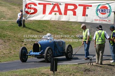
... surface hillclimbs in the world, the others being Shelsey Walsh and Prescott Hillclimbs in the UK. The first Light Car Club of Australia hillclimb was held at Rob Roy in February 1937. Jim Connor Collection 2016-05-12 Activities Christmas Hills ...Rob Roy-EDHS visit 12 May 2016 On 12th May 2016 some members of the Eltham District Historical Society and others were fortunate to have the opportunity to visit and explore the Rob Roy Hillclimb in Clintons Road, Christmas Hills. This followed an invitation from Don Kinsey and Wayne Ruston, members of the MG Car Club, which operates Rob Roy. At the time, both men were actively involved in the running of the meetings there, Don, an EDHS member, as a course commentator, with a wide range of motorsport experiences, and Wayne as the main organiser of the meetings. Don Kinsey welcomed the group and spoke about the historical background of the property and the hillclimb, then led those interested around the site and up the hillclimb track, stopping at spots along the way to provide additional information. Everyone enjoyed their experiences, including inspecting Wayne Ruston’s MGBV8. The Rob Roy Hill Climb originated in 1935 on the property of former Heidelberg Mayor, William Clinton, where he reared the Rob Roy breed of miniature ponies. He established Pleasure Grounds on part of the property attracting groups of Sunday visitors from Melbourne's inner suburbs. Visitors enjoyed a picnic area, pony rides, a dance hall and a tap room. Young men would ride their BSA or Harley Davidson motorcycles to the property which led to regular club-organised hillclimb meetings between 1930 and 1936. In 1935 Clinton offered the use of his property to the Light Car Club of Australia for their hillclimbs. The track was sealed that same year and the hillclimb at Clintons Road was one of only three specially designed bitumen surface hillclimbs in the world, the others being Shelsey Walsh and Prescott Hillclimbs in the UK. The first Light Car Club of Australia hillclimb was held at Rob Roy in February 1937.jim connor collection, 2016-05-12, activities, christmas hills, clintons road, heritage excursion, rob roy hill climb, eltham district historical society -
 Eltham District Historical Society Inc
Photograph, Fay Bridge, Rob Roy Hill Climb Circuit, Clintons Road, Christmas Hills, 7 September 2013
... surface hillclimbs in the world, the others being Shelsey Walsh and Prescott Hillclimbs in the UK. The first Light Car Club of Australia hillclimb was held at Rob Roy in February 1937. Activities Eltham District Historical Society Heritage Excursion Fay Bridge Collection 2016-05-12 Christmas Hills Clintons Road Rob Roy Hill Climb 39 images - born digital Rob Roy Hill Climb Circuit, Clintons Road, Christmas Hills Photograph Photograph Fay Bridge ...Rob Roy-EDHS visit 12 May 2016 On 12th May 2016 some members of the Eltham District Historical Society and others were fortunate to have the opportunity to visit and explore the Rob Roy Hillclimb in Clintons Road, Christmas Hills. This followed an invitation from Don Kinsey and Wayne Ruston, members of the MG Car Club, which operates Rob Roy. At the time, both men were actively involved in the running of the meetings there, Don, an EDHS member, as a course commentator, with a wide range of motorsport experiences, and Wayne as the main organiser of the meetings. Don Kinsey welcomed the group and spoke about the historical background of the property and the hillclimb, then led those interested around the site and up the hillclimb track, stopping at spots along the way to provide additional information. Everyone enjoyed their experiences, including inspecting Wayne Ruston’s MGBV8. The Rob Roy Hill Climb originated in 1935 on the property of former Heidelberg Mayor, William Clinton, where he reared the Rob Roy breed of miniature ponies. He established Pleasure Grounds on part of the property attracting groups of Sunday visitors from Melbourne's inner suburbs. Visitors enjoyed a picnic area, pony rides, a dance hall and a tap room. Young men would ride their BSA or Harley Davidson motorcycles to the property which led to regular club-organised hillclimb meetings between 1930 and 1936. In 1935 Clinton offered the use of his property to the Light Car Club of Australia for their hillclimbs. The track was sealed that same year and the hillclimb at Clintons Road was one of only three specially designed bitumen surface hillclimbs in the world, the others being Shelsey Walsh and Prescott Hillclimbs in the UK. The first Light Car Club of Australia hillclimb was held at Rob Roy in February 1937.activities, eltham district historical society, heritage excursion, fay bridge collection, 2016-05-12, christmas hills, clintons road, rob roy hill climb -
 Eltham District Historical Society Inc
Photograph - Digital Photograph, Alan King, Rob Roy Hill Climb, 24 November 2007
... surface hillclimbs in the world, the others being Shelsey Walsh and Prescott Hillclimbs in the UK. The first Light Car Club of Australia hillclimb was held at Rob Roy in February 1937. Covered under Heritage Overlay, Nillumbik Planning Scheme. Published: Nillumbik Now and Then / Marguerite Marshall 2008; photographs Alan King with Marguerite Marshall.; p133 About six times a year the unlikely sound of car engines emerges from deep in the heart of Christmas Hills.* Usually a quiet retreat, the Hills are home to one of the world’s oldest purpose-built motor sport venues - the Rob Roy Hillclimb. ...surface hillclimbs in the world, the others being Shelsey Walsh and Prescott Hillclimbs in the UK. The first Light Car Club of Australia hillclimb was held at Rob Roy in February 1937. Covered under Heritage Overlay, Nillumbik Planning Scheme. Published: Nillumbik Now and Then / Marguerite Marshall 2008; photographs Alan King with Marguerite Marshall.; p133 About six times a year the unlikely sound of car engines emerges from deep in the heart of Christmas Hills.* Usually a quiet retreat, the Hills are home to one of the world’s oldest purpose-built motor sport venues - the Rob Roy Hillclimb. ...The Rob Roy Hill Climb originated in 1935 on the property of former Heidelberg Mayor, William Clinton, where he reared the Rob Roy breed of miniature ponies. He established Pleasure Grounds on part of the property attracting groups of Sunday visitors from Melbourne's inner suburbs. Visitors enjoyed a picnic area, pony rides, a dance hall and a tap room. Young men would ride their BSA or Harley Davidson motorcycles to the property which led to regular club-organised hillclimb meetings between 1930 and 1936. In 1935 Clinton offered the use of his property to the Light Car Club of Australia for their hillclimbs. The track was sealed that same year and the hillclimb at Clintons Road was one of only three specially designed bitumen surface hillclimbs in the world, the others being Shelsey Walsh and Prescott Hillclimbs in the UK. The first Light Car Club of Australia hillclimb was held at Rob Roy in February 1937. Covered under Heritage Overlay, Nillumbik Planning Scheme. Published: Nillumbik Now and Then / Marguerite Marshall 2008; photographs Alan King with Marguerite Marshall.; p133 About six times a year the unlikely sound of car engines emerges from deep in the heart of Christmas Hills.* Usually a quiet retreat, the Hills are home to one of the world’s oldest purpose-built motor sport venues - the Rob Roy Hillclimb. When sealed in 1939, the hillclimb at Clintons Road was one of only three specially designed bitumen surface hillclimbs in the world, the others being Shelsley Walsh and Prescott Hillclimbs in the UK.1 The Rob Roy Hillclimb originated in 1935 on the property of former Heidelberg mayor, William Clinton, where he reared the Rob Roy breed of miniature ponies. Rob Roy was the Scottish folk hero and outlaw. On part of his property Clinton established Pleasure Grounds, attracting Sunday parties from Melbourne’s inner suburbs. Visitors enjoyed a picnic area, pony rides, a dance hall and a tap room.2 Young men riding on their BSA or Harley Davidson bikes led to club-organised regular hillclimb meetings, between 1930 and 1936. In 1935 Clinton offered his property to the Light Car Club of Australia for their hillclimbs. In February 1937, the first Light Car Club of Australia hillclimb meeting was held at Rob Roy. Jack Day achieved the fastest time that day for the 760 yard (695m) track at 36 seconds in a Ford V8 engined Bugatti Special. At first the climb was just a dusty gravel track, but in 1939 it was up-graded and bituminised. Today the 695 metre track begins on a slight incline, proceeds through a sharp right turn, which formerly passed a rusty iron shed, now remembered by the name Tin Shed Corner. The track continues down a slight incline to a level stretch along the top of an embankment holding back a half-acre (0.2ha) dam, then up to a one-in-three gradient. The track then winds uphill through several left turns to the finish line. In 1939 Frank Kleinig reduced the record to 29.72 seconds in an MG Hudson. Throughout World War Two the Rob Roy Hillclimbs were suspended, but were resumed in 1947. The hillclimbs consistently attracted crowds averaging 500 to 600 people, peaking at 2000, until the hillclimb was destroyed by the 1962 bushfires. The meetings included nine Australian Hillclimb Championships, with the first in 1938 won by Peter Whitehead in his ERA. Eight of the Outright and Class record holders were Australian Grand Prix winners including Jack Brabham, who became a triple F1 World Champion. The Light Car Club of Australia held 61 meetings at Rob Roy. Events usually included Touring, Gran Turismo, Production, Sports, Racing and Vintage cars and in the latter years Go-carts. These meets suddenly stopped after the 1962 bushfire destroyed the access bridge on the property leading to the track area, although fortunately Clinton saved his home. The club then established the Lakeland Hillclimb venue close to Lilydale.3 From 1979 to 1987 the MG Car Club ran hill climbs at the Templestowe Hillclimb until the land was to be sub-divided. In 1991 the MGCC approached the Shire of Nillumbik about using the derelict Rob Roy venue. In 1992, after much lobbying, the club signed a ten-year lease from Melbourne Water, which has been renewed. The original track was faithfully reconstructed. Access roads were improved and guard rails were installed on the causeway. Permanent structures were rebuilt and tonnes of rubbish removed. This was made possible by an immense amount of voluntary work by MGCC members and financial support from the newly formed Friends of Rob Roy. In February 1993 the first Return to Rob Roy Historic Meeting was run with a huge spectator attendance of around 1000 enthusiasts. In September 2007, the Nillumbik Shire Council gave the hillclimb heritage protection. This acknowledged the property’s significant contribution to early Australian motor sport with its social connection to William Clinton and the local community.4 *Christmas Hills was named after emancipated convict and shepherd David Christmas, lost in these hills.This collection of almost 130 photos about places and people within the Shire of Nillumbik, an urban and rural municipality in Melbourne's north, contributes to an understanding of the history of the Shire. Published in 2008 immediately prior to the Black Saturday bushfires of February 7, 2009, it documents sites that were impacted, and in some cases destroyed by the fires. It includes photographs taken especially for the publication, creating a unique time capsule representing the Shire in the early 21st century. It remains the most recent comprehenesive publication devoted to the Shire's history connecting local residents to the past. nillumbik now and then (marshall-king) collection, rob roy hill climb, clintons road, light car club of australia, william clinton -
 Bendigo Historical Society Inc.
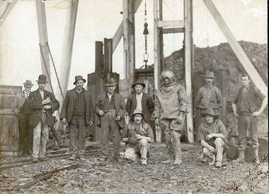
Photograph - TAMBOUR MAJOR MINE AT SPECIMEN HILL, 1920
... Surface equipment...tambour major mine...Bendigo... mines and mining... miners... mine... Specimen Hill...History House 11 Mackenzie Street Bendigo goldfields MINING Surface equipment tambour major mine Bendigo mines and mining miners mine Specimen Hill flooded mine diver Percival Pinder, Bendigo Black and white photograph mounted on brown board. ...Black and white photograph mounted on brown board. Ten males in front of mine shaft. One male in divers suit. Male second from L holding small dog. Cage and poppet legs in background. Mullock heap at back. Inscriptions: Hand written on BR corner of photo 'Percival Pinder, Photo, Bendigo' Hand written on board under photo 'Tambour Major GM Coy 846 ft'. On separate card glued to bottom of mount board, printed 'Diver inspecting flooded Tambour Major Mine at Specimen Hill in 1920'. Hand written in ball point pen on back 'Tambour Major' Mine Group photo taken at Tambour Major about 1920. Dad on extreme right, Joe Sheard, Mine Manager in diving suit. A Richardson, 29 Harrison Street' Hand printed in black ink on back 'Diver inspecting flooded Tambour Major Mine in 1920'. On back - circular purple stamp 'Royal Historical Society of Victoria, Bendigo Branch'.Percival Pinder, Bendigomining, surface equipment, tambour major mine, bendigo, mines and mining, miners, mine, specimen hill, flooded mine, diver -
 Bendigo Historical Society Inc.
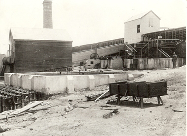
Photograph - Spargo's Pyrites Specimen Hill
... Surface equipment spargo's pyrites Bendigo mines and mining mining equipment equipment gold Black and white photo: industrial buildings with open tank and drums in foreground. Wooden building and ramp in middle ground. Chimney and shedding ( ? ) in background. BHS has other photo of this in its collection. Possibly Deeble's pyrites? James Lerk identified this as being Spargo's Pyrites - the picture appears in 'Bendigo's Gold Story' by Ralph W Birrell and James A Lerk. Photograph Spargo's Pyrites Specimen Hill ...Black and white photo: industrial buildings with open tank and drums in foreground. Wooden building and ramp in middle ground. Chimney and shedding ( ? ) in background. BHS has other photo of this in its collection. Possibly Deeble's pyrites? James Lerk identified this as being Spargo's Pyrites - the picture appears in 'Bendigo's Gold Story' by Ralph W Birrell and James A Lerk.mining, surface equipment, spargo's pyrites, bendigo, mines and mining, mining equipment, equipment, gold -
 Bendigo Historical Society Inc.
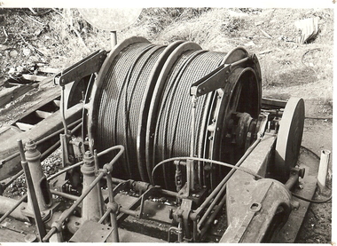
Photograph - WINDING ENGINE AT MONUMENT HILL MINE
... History House 11 Mackenzie Street Bendigo goldfields PLACE Mining site rope winding drum Mines and mining equipment mining equipment Bendigo mines mining surface equipment Black and white photograph of a winding engine (Roberts & Son) at Monument Hill Mine. ...Black and white photograph of a winding engine (Roberts & Son) at Monument Hill Mine. Winding gear, large drum with wire cable wound on, sitting on concrete base. Inscriptions: on back - lined paper, glued in centre 'Monument Hill Mine, Winding Engine, Roberts and Sons'.place, mining site, rope winding drum, mines and mining, equipment, mining equipment, bendigo, mines, mining, surface equipment -
 Bendigo Historical Society Inc.
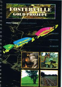
Document - FOSTERVILLE GOLD MINE COLLECTION: PROJECT UPGRADE TECHNICAL APPENDICES
... surface drainage study...noise emission to residential properties...flora survey...tailings dam site...flora survey Wellesford Forest...Daley's Hill...Hill." Page 1 'Perseverance Exploration Pty Limited' Book contains technical appendices. Topics: hydro geological assessment; surface drainage study, noise emission to residential properties, flora survey, tailings dam site; flora survey Wellesford Forest; Daley's Hill Plant List; diurnal Avifauna Survey - Wellesford Forest; survey of vertebrate fauna - Wellesford Forest; brief summary of fauna - Daley's Hill, Axedale, Aboriginal Archaeological survey; archaeological investigation Fosterville; traffic survey - Fosterville Sulphide Project; traffic report....Hill." Page 1 'Perseverance Exploration Pty Limited' Book contains technical appendices. Topics: hydro geological assessment; surface drainage study, noise emission to residential properties, flora survey, tailings dam site; flora survey Wellesford Forest; Daley's Hill Plant List; diurnal Avifauna Survey - Wellesford Forest; survey of vertebrate fauna - Wellesford Forest; brief summary of fauna - Daley's Hill, Axedale, Aboriginal Archaeological survey; archaeological investigation Fosterville; traffic survey - Fosterville Sulphide Project; traffic report. ...Black cover book, wire binding. Pages in reports numbered individually, overall approx 250 page report. On front: "Fosterville Gold Project' Project upgrade, EES Technical Appendix B. Central North, Central Ellesmere, Harringtons Hill." Page 1 'Perseverance Exploration Pty Limited' Book contains technical appendices. Topics: hydro geological assessment; surface drainage study, noise emission to residential properties, flora survey, tailings dam site; flora survey Wellesford Forest; Daley's Hill Plant List; diurnal Avifauna Survey - Wellesford Forest; survey of vertebrate fauna - Wellesford Forest; brief summary of fauna - Daley's Hill, Axedale, Aboriginal Archaeological survey; archaeological investigation Fosterville; traffic survey - Fosterville Sulphide Project; traffic report.bendigo, mining, fosterville gold mine, hydro geological assessment, surface drainage study, noise emission to residential properties, flora survey, tailings dam site, flora survey wellesford forest, daley's hill plant list, diurnal avifauna survey - wellesford forest, survey of vertebrate fauna - wellesford forest, brief summary of fauna - daley's hill, axedale, aboriginal archaeological survey, archaeological investigation fosterville, traffic survey - fosterville sulphide project, traffic report. -
 Bendigo Historical Society Inc.
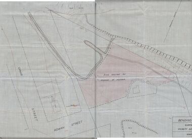
Plan - MCCOLL, RANKIN AND STANISTREET COLLECTION: PLAN OF MONUMENT HILL BATTERY
... Written on back of plan ' Monument Hill Battery site, area desired by Bendigo Mines (Nell Gwynne) for disposal of mullock. Plan shows Ophir Street, Rowan Street, Written on bottom RH corner 'Bendigo Mines Ltd., surface plan, vicinity Nell Gwynne Shaft, Scale 1" = 40' Magnetic north marked, sand dumps and contour lines....Written on back of plan ' Monument Hill Battery site, area desired by Bendigo Mines (Nell Gwynne) for disposal of mullock. Plan shows Ophir Street, Rowan Street, Written on bottom RH corner 'Bendigo Mines Ltd., surface plan, vicinity Nell Gwynne Shaft, Scale 1" = 40' Magnetic north marked, sand dumps and contour lines. ...Pale blue waxed paper plan. Written on back of plan ' Monument Hill Battery site, area desired by Bendigo Mines (Nell Gwynne) for disposal of mullock. Plan shows Ophir Street, Rowan Street, Written on bottom RH corner 'Bendigo Mines Ltd., surface plan, vicinity Nell Gwynne Shaft, Scale 1" = 40' Magnetic north marked, sand dumps and contour lines.bendigo, business, mccoll, rankin & stanistreet -
 Bendigo Historical Society Inc.
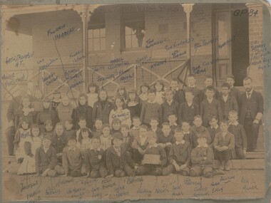
Photograph - CALIFORNIA GULLY PRIMARY SCHOOL 1901, July 1901
... Names of many pupils are noted in ballpoint ink on surface of the print together with the two teachers names. In grey lead pencil ' Belltopper Hill S.S. 1901' G.P. 84 in ink top RH corner. ...Names of many pupils are noted in ballpoint ink on surface of the print together with the two teachers names. In grey lead pencil ' Belltopper Hill S.S. 1901' G.P. 84 in ink top RH corner. ...sepia photograph: California Gully State School pupils of Grade 4. Class board shows ' No. 125, G IV' Photo shows two adult males ( Head teacher and assistant) . Four rows of students. Names of many pupils are noted in ballpoint ink on surface of the print together with the two teachers names. In grey lead pencil ' Belltopper Hill S.S. 1901' G.P. 84 in ink top RH corner. Written on back in ball point ' taken July 1901 ( I was 10 years of age ) prev. no. 2000-561-01 Names of students printed on photo: Abercrombie H.T., Millie Ferguson, Lily Cresswell, Laura Carter, Florrie Herbert, Florrie Lewis, Bertha Walter, Warren Anr, White, Schilling, Mable Trewarther, Nelly Neerhot, McKerliek Tom Hutchison, Gam Richards, Les Ennor,Bill Palmer, Bob Sporle, Christie, Bob Merrifield, Merriefield, Alice Cruse, Bodilly, McKerlie, Les Martin ( killed in mine ) Sam Jury, Elksie Ennor, Herb Pearce, Maude Christie, Reeves, Jack Hills, Bob Sporle, T. Hill, E. Collier, Valentine, Lily Jackson, Jack Nills, Les Mathews, Claude Hocking, Norm Evely, Paynting, Reg Miller, C.A. Searby ( later Principal of Melbourne Boys' High School )organization, education, california gully p.s. -
 The Beechworth Burke Museum
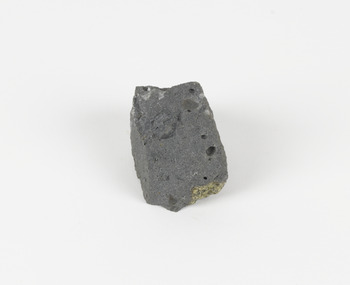
Geological specimen - Basalt (igneous-volcanic) containing Olivine, unknown
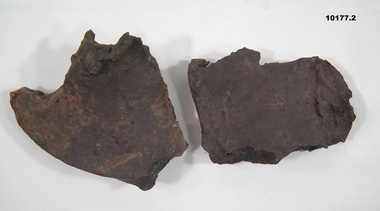
... hill of loose pyroclastic fragments) which was created by a volcanic eruption about 470,000 years ago, a date which may indicate the age of this geological specimen. The volcanic eruptions of Mount Franklin were most likely witnessed by members of the Dja Dja Wurrung Aboriginal tribe, who referred to this country as the 'smoking grounds'. Mount Franklin and the surrounding area appears to have been a place of considerable religious significance to Aboriginal people, there is evidence which indicates that frequent large ceremonial gatherings took place in the area. Basalt is the most common rock on Earth’s surface...hill of loose pyroclastic fragments) which was created by a volcanic eruption about 470,000 years ago, a date which may indicate the age of this geological specimen. The volcanic eruptions of Mount Franklin were most likely witnessed by members of the Dja Dja Wurrung Aboriginal tribe, who referred to this country as the 'smoking grounds'. Mount Franklin and the surrounding area appears to have been a place of considerable religious significance to Aboriginal people, there is evidence which indicates that frequent large ceremonial gatherings took place in the area. Basalt is the most common rock on Earth’s surface ...This particular geological specimen was found in Mount Franklin or Lalgambook in Djadjawurrung, located between Daylesford and Newstead, approximately ninety minutes drive from Melbourne. The mountain is an example of a breached scoria cone (a steep conical hill of loose pyroclastic fragments) which was created by a volcanic eruption about 470,000 years ago, a date which may indicate the age of this geological specimen. The volcanic eruptions of Mount Franklin were most likely witnessed by members of the Dja Dja Wurrung Aboriginal tribe, who referred to this country as the 'smoking grounds'. Mount Franklin and the surrounding area appears to have been a place of considerable religious significance to Aboriginal people, there is evidence which indicates that frequent large ceremonial gatherings took place in the area. Basalt is the most common rock on Earth’s surface, more than 90% of all volcanic rock on Earth is basalt. Basalt is an aphanitic extrusive igneous rock formed from the rapid cooling of low-viscosity lava exposed at or very near the surface of a rocky planet or moon. Specimens are black in colour and weather to dark green or brown. Basalt is rich in iron and magnesium and is mainly composed of olivine, pyroxene, and plagioclase. Olivine is the name of a group of rock-forming silicate minerals with compositions ranging between Mg2SiO4 and Fe2SiO4. Unlike other minerals, Olivine has a very high crystallisation temperature which makes it the first of the minerals to crystallise from magma. As magma cools, the crystals begin to form and settle on the bottom of the lava and form basalts that are abnormally enriched in olivine in the lower part of lava flows. According to H. M. King (on geology.com) "Olivine is thought to be an important mineral in Earth's mantle. Its presence as a mantle mineral has been inferred by a change in the behaviour of seismic waves as they cross the boundary between Earth's crust and mantle". Lava from Mount Franklin and other volcanoes in the area filled valleys and buried the gold bearing streams that became the renowned ‘deep leads’ of the gold mining era. In 1852, as part of the Victorian gold rush, gold was discovered in the immediate area, this gold was created by lava flows during the Newer Volcanic period, which were mined intensively during the nineteenth century. Around 1865 the presence of a deep lead in Mount Franklin was established. Deep lead mining was initially unsuccessful, and it was not until the late 1870s that the Franklinford Gold Mining Company mined at Mount Franklin on a significant scale. A few years later the Mount Franklin Estate Gold Mining Company also struck gold, followed by the Shakespeare and Great Western companies in the mid-1880s. By the late 1880s, however, deep lead mining had ceased in the area. Soon after gold was discovered in 1851, Victoria’s Governor La Trobe wrote to the Colonial Office in London, urging ‘the propriety of selecting and appointing as Mineral Surveyor for this Colony a gentleman possessed of the requisite qualifications and acquaintance with geological science and phenomena’. Alfred Selwyn was appointed geological surveyor in Australia in 1852 which began the Geological Survey of Victoria. In 1853-69 the Geological Survey issued under Selwyn's direction sixty-one geological maps and numerous reports; they were of such high standard that a writer in the Quarterly Journal of the Geological Society of London bracketed the survey with that of the United States of America as the best in the world. During his years spent in Australia, Selwyn collected numerous significant geological specimens, examples of which are held in collections such as the Burke Museum.This geological specimen is an example of basalt and olivine which shows the volcanic lava activity and geographical specific nature of Mt Franklin as a significant volcanic site. According to Agriculture Victoria 'The crater is one of the deepest in the Central Highlands area. It is a major megacryst site with some of the largest known Victorian examples of megacrysts of augite and an orthoclase. The small parasitic mound of Lady Franklin on the western flanks adds to the geological interest of the site'. This specimen also highlights the locality as a significant place for both indigenous activity and Victorian gold rush era mining practices. This specimen is part of a larger collection of geological and mineral specimens collected from around Australia (and some parts of the world) and donated to the Burke Museum between 1868-1880. A large percentage of these specimens were collected in Victoria as part of the Geological Survey of Victoria that begun in 1852 (in response to the Gold Rush) to study and map the geology of Victoria. Collecting geological specimens was an important part of mapping and understanding the scientific makeup of the earth. Many of these specimens were sent to research and collecting organisations across Australia, including the Burke Museum, to educate and encourage further study.An angular, solid hand-sized piece of grey volcanic Basalt with green/brown Olivine phenocrysts along one flat edge.Olivine in basalt / - label is probably / correct. / C. Willman / 15/4/21burke museum, beechworth, indigo shire, beechworth museum, geological, geological specimen, mineralogy, basalt, igneous rock, igneous-volcanic, volcanic geology, volcanic, olivine, olivine specimen, basaltoid -
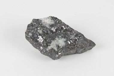 The Beechworth Burke Museum
Geological specimen - Galena (with quartz), unknown
... Hill Mining Company eventually evolved into BHP group limited and is currently the largest mining company in the world and the largest company in Australia. There is archaeological evidence from artefacts discovered in Turkey that humans have been extracting lead from galena by the process of smelting since at least 6500 BCE. This specimen also has quartz on the top surface...Hill Mining Company eventually evolved into BHP group limited and is currently the largest mining company in the world and the largest company in Australia. There is archaeological evidence from artefacts discovered in Turkey that humans have been extracting lead from galena by the process of smelting since at least 6500 BCE. This specimen also has quartz on the top surface ...Galena is the natural compound of lead and classed as a sulphide, it crystallises in a cubic pattern and its chemical formula is PbS. Galena is a primary source of both lead and silver. This specimen of Galena comes from Broken Hill. Broken Hill has one of the world’s largest and most significant deposit of ore for the production of lead. Mining of Galena at Broken Hill began with the staking of land by Charles Rasp in 1883. By the following year, in 1884, Rasp and six others had formed Broken Hill Mining Company. Broken Hill Mining Company eventually evolved into BHP group limited and is currently the largest mining company in the world and the largest company in Australia. There is archaeological evidence from artefacts discovered in Turkey that humans have been extracting lead from galena by the process of smelting since at least 6500 BCE. This specimen also has quartz on the top surface which is frequently discovered alongside Galena. This mineral specimen is of historic significance as a sample of Galena extracted from Broken Hill during the 19th century. Mining for Galena in Broken Hill begin in 1883 by Charles Rasp and evolved into the world’s largest mining company – BHP Group Limited. Broken Hill is one of the world’s most significant deposits of ore for the production of lead. This specimen is part of a larger collection of geological and mineral specimens collected from around Australia (and some parts of the world) and donated to the Burke Museum between 1868-1880. A large percentage of these specimens were collected in Victoria as part of the Geological Survey of Victoria that begun in 1852 (in response to the Gold Rush) to study and map the geology of Victoria. Collecting geological specimens was an important part of mapping and understanding the scientific makeup of the earth. Many of these specimens were sent to research and collecting organisations across Australia, including the Burke Museum, to educate and encourage further study.A flat, hand-sized, grey sulphide specimen that is the natural compound of lead with a quartz formation on the top surface. Existing Label: GALENA / (with quartz) / Locality: Broken Hill / N.S.W 120 x 70 x 29geological specimen, geology, geology collection, burke museum, beechworth, galena, galena quartz, quartz, charles rasp, broken hill mining company, bhp group limited, bhp, lead, ore, lead sulphide, sulphide, silver, broken hill