Showing 67 items matching "surface site"
-
 Bendigo Historical Society Inc.
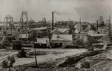
Photograph - MINING SITE
... ...surface site...History House 11 Mackenzie Street Bendigo goldfields MINING Surface equipment surface site Bendigo mines and mining mines mining poppet heads mine buildings Black and white photograph of many mines. ...Black and white photograph of many mines. At least 12 poppet heads and four chimneys. Mine buildings, mullock heaps. Inscriptions: in image, on building 'Duchess Tribute CoMc'. In margin at BL in pencil '12'. On back in pencil - '12', in ball point pen 'Devonshire Group'. In black ink 'MNG 22'. Blue circular stamp 'Royal Historical Society of Victoria, Bendigo Branch'.mining, surface equipment, surface site, bendigo, mines and mining, mines, mining, poppet heads, mine buildings -
 Bendigo Historical Society Inc.
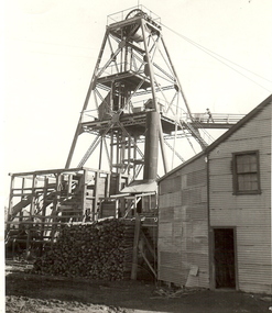
Photograph - MINE POPPET HEAD
... ...surface site...History House 11 Mackenzie Street Bendigo goldfields MINING Surface equipment surface site Bendigo mines and mining mines mine poppet head mining shed Black + White Photograph. ...Black + White Photograph. Poppet Head with tubular steel legs, lattice stays and cross bracing. 1 Male pushing one track on overhead trackway from first landing platemans cubby or first landing. Wincher house, wood stack, chimney shed without coverin On back 'A,156' Signature 'R. Stanistreet.' 'Poppet head of a Bendigo Mine'. Stamped Australian Nations Travel Association.mining, surface equipment, surface site, bendigo, mines and mining, mines, mine, poppet head, mining shed -
 Bendigo Historical Society Inc.
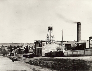
Photograph - MINE WINDER HOUSE
... ...surface site...History House 11 Mackenzie Street Bendigo goldfields Surface equipment surface site Bendigo mines and mining mine mining poppet head transport dray mining landscape landscape Black and white photograph. ...Black and white photograph. Mine winder house, poppet head, ore bins, chimney and shed. Residences adjacent to mine and streets. Poppet heads visible in far background. surface equipment, surface site, bendigo, mines and mining, mine, mining, poppet head, transport, dray, mining landscape, landscape -
 Bendigo Historical Society Inc.
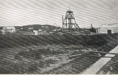
Photograph - MINE SITE
... ...surface site...History House 11 Mackenzie Street Bendigo goldfields MINING Surface equipment surface site Bendigo mines and mining mines mine mining poppet head landscape mining town Black and white photograph : view of mine workings in foreground - two poppet heads, building and chimney. ...Black and white photograph : view of mine workings in foreground - two poppet heads, building and chimney. Town ( housing ) in background. Chimney at bottom right with pointed top.mining, surface equipment, surface site, bendigo, mines and mining, mines, mine, mining, poppet head, landscape, mining town -
 Bendigo Historical Society Inc.
Photograph - MINING SITE
... ...surface site...History House 11 Mackenzie Street Bendigo goldfields MINING Surface equipment surface site Mining site. As there is no information re this Photo it would appear to be that it could be a mining site being erected or dismantled. ...As there is no information re this Photo it would appear to be that it could be a mining site being erected or dismantled.mining, surface equipment, surface site, mining site. -
 Bendigo Historical Society Inc.
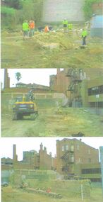
Photograph - FOREST STREET BUILDING SITE, ARCHAEOLOGICAL STUDY 2009
... Images show cleared site, workmen and women on site inspecting surface area prior to archaeological study being undertaken....Images show cleared site, workmen and women on site inspecting surface area prior to archaeological study being undertaken. ...Copy of three colour images of demolition of building site in Forest Street in 2009/. Images show cleared site, workmen and women on site inspecting surface area prior to archaeological study being undertaken.buildings, commercial, forest street, forest street, archaeology -
 Bendigo Historical Society Inc.
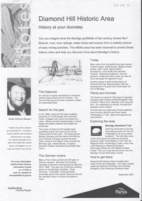
Document - DIAMOND HILL HISTORIC AREA PARKS VICTORIA
... On second page is a map of the area showing historic features: Deborah Consolidated Gold workings Red, White and Blue Extended gold workings Goldfields Extended gold workings Dead Dog Gully, alluvial gold workings Glasgow & Golconda Gold workings and tramway Surface gold mining site Hansel Mundy gold workings Bendigo Goldfields Pty gold workings Stafford gold workings Langdon gold workings Great Opossum Gully alluvial gold workings...On second page is a map of the area showing historic features: Deborah Consolidated Gold workings Red, White and Blue Extended gold workings Goldfields Extended gold workings Dead Dog Gully, alluvial gold workings Glasgow & Golconda Gold workings and tramway Surface gold mining site Hansel Mundy gold workings Bendigo Goldfields Pty gold workings Stafford gold workings Langdon gold workings Great Opossum Gully alluvial gold workings Document DIAMOND HILL HISTORIC AREA PARKS VICTORIA ...Document, two pages, prepared by Parks Victoria in relation to the Diamond Hill Historic Area. Contains information regarding the history of the area; German Miners; Plants and animals. On second page is a map of the area showing historic features: Deborah Consolidated Gold workings Red, White and Blue Extended gold workings Goldfields Extended gold workings Dead Dog Gully, alluvial gold workings Glasgow & Golconda Gold workings and tramway Surface gold mining site Hansel Mundy gold workings Bendigo Goldfields Pty gold workings Stafford gold workings Langdon gold workings Great Opossum Gully alluvial gold workingsbendigo, mining, diamond hill -
 Bendigo Historical Society Inc.
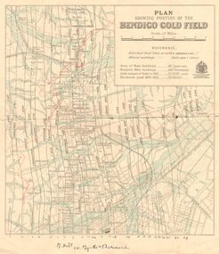
Map - DEPARTMENT OF MINES VICTORIA : PLAN SHOWING PORTION OF THE BENDIGO GOLD FIELD
... Additional information: anticlinal axial lines at surface, alluvial workings, shaft sites, area of Main Goldfield, Deepest mine workings, Gold output of field to 1935, and Dividends paid 1870 - 1935....Additional information: anticlinal axial lines at surface, alluvial workings, shaft sites, area of Main Goldfield, Deepest mine workings, Gold output of field to 1935, and Dividends paid 1870 - 1935. ...Department of Mines Victoria. Plan showing portion of the Bendigo Gold Field. On the back is written, in ink, J. J. Tyler 1937 Northern Area. (He was a teacher at Bendigo High - see donation notes). Across the bottom of the map is written ' M. Hill cr. Myrtle & Barnard' .The named reef lines have been numbered with ink across the bottom of the map. The gullies have been coloured with green pencil and a red pencil line is drawn through the western side of the map. Additional information: anticlinal axial lines at surface, alluvial workings, shaft sites, area of Main Goldfield, Deepest mine workings, Gold output of field to 1935, and Dividends paid 1870 - 1935.bendigo, gold mining, bendigo gold field. gold mining. tyler, j. j. -
 Warrnambool and District Historical Society Inc.
Tools, Name Stamp, Late 19th century/early 20th century
... surfaces. Ernest Brighton Phillips (1875-1924) was born in Warrnambool and was apprenticed as a cabinet maker at the Warrnambool Box Works. By the 1890s he had established a furniture shop at the corner of Liebig and Koroit Streets and by the beginning of the 20th century he had the largest furniture warehouse and factory in Victoria outside of Melbourne. His products were sold all over Australia. He and his family lived at ‘Heatherlie’ in Koroit Street and today this site...surfaces. Ernest Brighton Phillips (1875-1924) was born in Warrnambool and was apprenticed as a cabinet maker at the Warrnambool Box Works. By the 1890s he had established a furniture shop at the corner of Liebig and Koroit Streets and by the beginning of the 20th century he had the largest furniture warehouse and factory in Victoria outside of Melbourne. His products were sold all over Australia. He and his family lived at ‘Heatherlie’ in Koroit Street and today this site ...This is the stamp used by Ernest Phillips to mark his tools and his products. It was used both on wood and metal surfaces. Ernest Brighton Phillips (1875-1924) was born in Warrnambool and was apprenticed as a cabinet maker at the Warrnambool Box Works. By the 1890s he had established a furniture shop at the corner of Liebig and Koroit Streets and by the beginning of the 20th century he had the largest furniture warehouse and factory in Victoria outside of Melbourne. His products were sold all over Australia. He and his family lived at ‘Heatherlie’ in Koroit Street and today this site is occupied by the flats complex for senior citizens called ‘Heatherlie’. This stamp is of interest because it belonged to Ernest Phillips, a prominent Warrnambool businessman (late 1800s to the early 1900s.) It is also of interest as an example of an early name stamp. This is a small piece of metal with a rounded flange top and a wider flattened end. The end is serrated and cut to hold the letters, ‘E. Phillips’. Some white paint has been splashed on the end section.‘E.Phillips’ (letters reversed for stamping purposes)ernest phillips, history of warrnambool -
 Warrnambool and District Historical Society Inc.
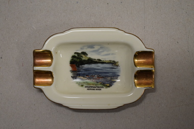
Ashtray, Alka Kunst, Warrnambool Hopkins River, c. 1960
... site in Henna Street and used for indoor recreational purposes. This ash tray is retained as an example of a local tourist souvenir sold to tourists in the 1960s. Tourism in Warrnambool History of Warrnambool Warrnambool Hopkins River Alka Kunst Bavaria This is a small white china dish made in an oval shape and slightly raised from the surface on which it sits. ...This item was bought as a souvenir of Warrnambool in the mid 20th century when cigarette smoking was more widespread and was socially acceptable. Tourism in Warrnambool has been an important industry for over 100 years. In the late 19th century Warrnambool was promoted as a spa resort with its mild climate, sea bathing and its hot and cold sea water baths complex. Today visitors come in winter for the May Racing Carnival and to see the Southern Right whales at Logans Beach and in summer they come for a beach holiday. The image on the dish shows the Warrnambool Hopkins River near its mouth. The boatshed is no longer there with sections of the building being relocated to a site in Henna Street and used for indoor recreational purposes.This ash tray is retained as an example of a local tourist souvenir sold to tourists in the 1960s. This is a small white china dish made in an oval shape and slightly raised from the surface on which it sits. The ends of the dish have four gold coloured indents for stubbing cigarettes. There is a gold rim around the edge of the dish and a coloured image of the old boat shed and jetty on the Hopkins River in Warrnambool. On the base of the dish is the logo of the maker and printed details.Warrnambool Hopkins River Alka Kunst Bavaria tourism in warrnambool, history of warrnambool -
 Bendigo Military Museum
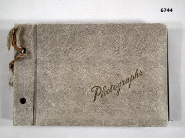
Album - ALBUM, PHOTOGRAPH, Photo Album of graves and important sites of 38 Bn men WW1
... surface resembling animal fur. The word photographs is embossed in gold on the front. It is bound with a cord (broken) thru 2 holes. Under each photo is a tag showing deceased soldier's name. The album has about 20 pages. The B & W photos are size 7.2 x 5.0 cms. Photo Album of graves and important sites ...38 Bn was raised 1 Mar 1916 in Bendigo during WW1. it was initially about 500 men.Photo album has a light gray surface resembling animal fur. The word photographs is embossed in gold on the front. It is bound with a cord (broken) thru 2 holes. Under each photo is a tag showing deceased soldier's name. The album has about 20 pages. The B & W photos are size 7.2 x 5.0 cms.passchendaele barracks trust, ww1, 38th bn -
 Kiewa Valley Historical Society
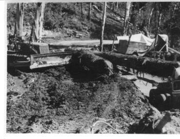
Photograph, logging at McKay Creek, Logging at McKay Creek, c1950's
... site did not commence until 1951 but road access(a narrow track) was provided in 1948 and widened in 1954. The logs would have been milled for timber at the State Electricity Commission's mill at Howman's Gap and thus provided a much needed source of timber for construction of camps and houses as there was a general of shortage of this commodity. Because of trouble with landslides in this area, a decision was made to place the machine hall of the power station underground instead of on the surface...site did not commence until 1951 but road access(a narrow track) was provided in 1948 and widened in 1954. The logs would have been milled for timber at the State Electricity Commission's mill at Howman's Gap and thus provided a much needed source of timber for construction of camps and houses as there was a general of shortage of this commodity. Because of trouble with landslides in this area, a decision was made to place the machine hall of the power station underground instead of on the surface ...This photograph was probably taken at the site of McKay Creek Power Station. Excavation of this site did not commence until 1951 but road access(a narrow track) was provided in 1948 and widened in 1954. The logs would have been milled for timber at the State Electricity Commission's mill at Howman's Gap and thus provided a much needed source of timber for construction of camps and houses as there was a general of shortage of this commodity. Because of trouble with landslides in this area, a decision was made to place the machine hall of the power station underground instead of on the surface. Restricted financial resources and the repositioning of the power station retarded construction activities and it was not completed until early 1961.. An excellent pictorial record of the general working conditions, type of machinery and vehicles in use in the 1950/s.Black and white photograph showing logging equipment, fallen logs.Handwritten on the back of the photograph "Logging at McKay Creek)logging, mckay creek, timber, machinery -
 Bendigo Military Museum
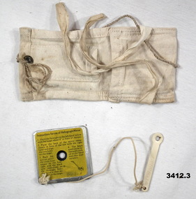
Equipment - HELIOGRAPH MIRROR, Department of Defence, possibly WW2 era
... Bendigo Military Museum 37 - 39 Pall Mall Bendigo goldfields heliograph mirror ground to air .1) On rear yellow sticker / black print: "Instructions for use of Heliograph Mirror & illustration" .2) Site stamped one side: "27H / 2107" .3) Faded stencil on flap: "Heliograph" Emergency signaling mirror - Ground to Air .1) Bright polished steel. Cross hairs engraved on reflective surface ...Emergency signaling mirror - Ground to Air .1) Bright polished steel. Cross hairs engraved on reflective surface. Rear face has instructions for use, yellow sticker with black print. .2) Sight. Long piece with viewing hole at end, painted white. .3) White cotton container with tie straps..1) On rear yellow sticker / black print: "Instructions for use of Heliograph Mirror & illustration" .2) Site stamped one side: "27H / 2107" .3) Faded stencil on flap: "Heliograph" heliograph, mirror, ground to air -
 Kiewa Valley Historical Society
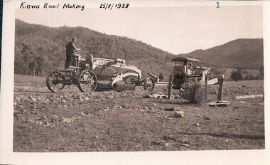
Black and White photograph of Road Making Machinery, Kiewa Road Making, 25/08/1938
... surfaced. The purchase and use of this type of mechanical equipment in road making was a huge investment, as prior to this most of the work would have been done manually with the use of picks and shovels. Not only were many months of hard manual labour saved, but a very significant amount of time in providing access to the proposed work sites for the new Kiewa Hydro Scheme. ...Construction of the main road from South Tawonga to the Bogong High Plains, to provide access to the construction sites for the new Kiewa Hydro Electric Scheme, was commenced early in 1938, the work being undertaken on behalf of the Commission by the Country Roads Board. For the construction work, the Commission purchased three Caterpillar - model R07 - diesel crawler tractors equipped with Kay Brunerei (Brunner) hydraulically operated trailbuilders (angle dozers). This acquisition resulted from a visit to the United States of America in May, 1937 by the Construction Engineer ( Mr. C.H. Kernot) and Assistant Civil Engineer (Mr. J.F. Douglas) where they saw this relatively new type of equipment in use. With the co-operation of the CRB, the Commission demonstrated the operation of these machines at Fishermen's Bend on 6th April, 1938. They were then sent to Kiewa where they commenced operation towards the end of the month. From South Tawonga, the route led immediately across the Western Branch of the Kiewa River necessitating the construction of a bridge 100 feet long. By the end of 1939, the excavation had been 'opened up' for a distance of 19 1/2 miles (approx. 31 km) and of this length, 10 miles (approx. 16 km) had been surfaced.The purchase and use of this type of mechanical equipment in road making was a huge investment, as prior to this most of the work would have been done manually with the use of picks and shovels. Not only were many months of hard manual labour saved, but a very significant amount of time in providing access to the proposed work sites for the new Kiewa Hydro Scheme. This photo is an excellent reminder of how primitive the early machinery was compared to the present but also represents the forward thinking of the State Electricity Commissions engineers in purchasing such innovative equipment . A black and white photograph showing the type of machinery used for road making in the 1930's. It shows a grader being towed by a caterpillar tractor.On the top left hand corner of the photograph , hand written in black ink is the words 'Kiewa Road Making 25/8/1938'. On the right hand side of the photo has been stamped in blue the Number 1. It has been developed on Velox paper (marked on back of photo) with a gloss finish.road making, state electricity commission, caterpillar tractor, kiewa -
 Kiewa Valley Historical Society
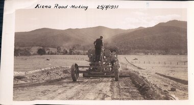
Black and White photograph of Road Making Machinery, Kiewa Road Making 25/08/1938 No. 2, 25/08/1938
... surfaced. (see KVHS 0328) The purchase of this type of mechanical equipment in road making was a huge investment, as prior to this most of the work would have been done manually with the use of picks and shovels. Not only were many months of hard manual labour saved, but a very significant amount of time in providing access to the proposed work sites for the new Kiewa Hydro Scheme. ...Construction of the main road from South Tawonga to the Bogong High Plains, to provide access to the construction sites for the new Kiewa Hydro Electric Scheme, was commenced early in 1938, the work being undertaken on behalf of the commission by the Country Roads Board. For the construction work, the Commission purchased three Caterpillar - model R07 - diesel crawler tractors equipped with Kay Brunerei (Brunner) hydraulically operated trailbuilders (angle dozers). This acquisition resulted from a visit to the United States of America in May, 1937 by the Construction Engineer ( Mr. C.H. Kernot) and Assistant Civil Engineer ( Mr. J.F. Douglas) where they saw this relatively new type of equipment in use. With the co-operation of the CRB, the Commission demonstrated the operation of these machines at Fishermen's Bend on 6th April, 1938. They were then sent to Kiewa where they commenced operation towards the end of the month. From South Tawonga, the route let immediately across the Western Branch of the Kiewa River necessitating the construction of a bridge 100 feet long. By the end of 1939, the excavation had been 'opened up' for a distance of 19 1/2 miles (approx. 31 km.) and of this length, 10 miles (approx. 16 km.) had been surfaced. (see KVHS 0328)The purchase of this type of mechanical equipment in road making was a huge investment, as prior to this most of the work would have been done manually with the use of picks and shovels. Not only were many months of hard manual labour saved, but a very significant amount of time in providing access to the proposed work sites for the new Kiewa Hydro Scheme. This photo is an excellent reminder of how primitive the early machinery was compared to the present but also represents the forward thinking of the State Electricity Commissions engineers in purchasing such innovative equipment.A black and white photograph of road making near Mt. Beauty in 1938. Mount Beauty hills can be seen in the background with cleared land for grazing in the fore ground.Hand printed in black ink at the top of the photograph is 'Kiewa Road Making 25/8/1938'. On the right hand corner has been printed the number 2. It has been printed on gloss Velox paper.road making, state electricity commission, caterpillar tractor, kiewa, secv -
 Kiewa Valley Historical Society
Core Rock Samples
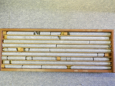
... The core samples in the display cabinet were obtained from the various sites at which drilling into the rock surface was carried out (under the control of design and structural engineers of the SEC Kiewa Hydro Scheme - late 1940's). ...Kiewa Valley Historical Society Mount Beauty Information Centre 31 Bogong High Plains Rd Mt Beauty high-country The core samples in the display cabinet were obtained from the various sites at which drilling into the rock surface was carried out (under the control of design and structural engineers of the SEC Kiewa Hydro Scheme - late 1940's). ...The core samples in the display cabinet were obtained from the various sites at which drilling into the rock surface was carried out (under the control of design and structural engineers of the SEC Kiewa Hydro Scheme - late 1940's). This function was a precursor to the decision where to locate, in this case, the McKay Creek Power Station. The information gained by structural engineers from the core samples would be used also for the placements of underground tunnels entry and exit points and the overall effective size of the generator plant. This would have included drill and blast techniques (rock characteristics play an import part of explosion control), requirements for support structures and reinforcing cement/steel forms. The use and replenishment of diamond drill bits(the strongest available, see KVHS 0280) was dependent on the "type" of rock found (harder rock required greater numbers of drill bits). Support beams for reinforced ceilings and floors was also a necessity.These rock core samples are very significant in the formulation and placement of the underground Power Stations and their maze of tunnels (in and out) for a successful implementation of the Hydro Scheme. The amount of pre-planning and engineering studies required for such a large scheme must be undertaken to ensure that a "white elephant" was not the result.There are nine columns of rock cores, each 30mm in diameter, set in a wooden display rack. A clear plastic (slide out) protective panel is installed to the front section. Within each column are block details of the depth from which that section was brought from. See KVHS for the appropriate sketch details.Depth levels (retrieved from) are shown for each section on wooden Blocks: 1st Block: "7'10" (seven feet, ten inches), 2nd Block:"9'4" (nine feet, four inches), 3rd Block: "19'3" (nineteen feet, three inches), 4th Block: "24'2" (twenty four feet, two inches), 5th Block: "25'7"( twenty five feet, seven inches) and last block: "30' (thirty feet)"alternate energy supplies, alpine feasibility studies temperature, rainfall, sec, kiewa hydro scheme, electricity -
 Kiewa Valley Historical Society
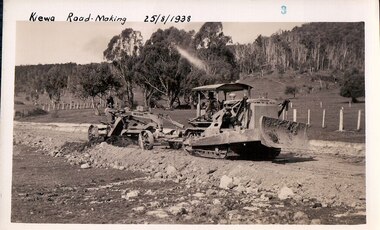
Black and White photograph of Road Making Machinery, Kiewa Road Making 25/8/1938(No. 3 in a series of 8), 25/08/1938
... surfaced. The purchase and use of this type of mechanical equipment in road making was a huge investment, as prior to this most of the work would have been done manually with the use of picks and shovels. Not only were many months of hard manual labour saved, but a very significant amount of time in providing access to the proposed work sites for the new Kiewa Hydro Scheme. ...Construction of the main road from South Tawonga to the Bogong High Plains, to provide access to the construction sites for the new Kiewa Hydro Electric Scheme, was commenced early in 1938, the work being undertaken on behalf of the Commission by the Country Roads Board. For the construction work, the Commission purchased three Caterpillar - model R07 - diesel crawler tractors equipped with Kay Brunerei (Brunner) hydraulically operated trail builders (angle dozers)). This acquisition resulted from a visit to the United States of America in May, 1937 by the Construction Engineer ( Mr. C.H. Kernot) and Assistant Civil Engineer (Mr. J.F. Douglas) where they saw this relatively new type of equipment in use. With the co-operation of the CRB, the Commission demonstrated the operation of these machines at Fishermen's Bend on 6th April, 1938. They were then sent to Kiewa where they commenced operation towards the end of the month. From South Tawonga, the route led immediately across the Western Branch of the Kiewa River necessitating the construction of a bridge 100 feet long. By the end of 1939,the excavation had been 'opened up' for a distance of 19 1/2 miles (approx. 31 km.) and of this length, 10 miles (approx. 16 km) had been surfaced.The purchase and use of this type of mechanical equipment in road making was a huge investment, as prior to this most of the work would have been done manually with the use of picks and shovels. Not only were many months of hard manual labour saved, but a very significant amount of time in providing access to the proposed work sites for the new Kiewa Hydro Scheme. This photo is an excellent reminder of how primitive the early machinery was compared to the present but also represents the forward thinking of the State Electricity Commission's Engineers in purchasing such new and innovative equipment.A black and white photograph of a Caterpillar diesel crawler tractor and a hydraulically operated trailbuilder (angle dozer) making a road in the Mt. Beauty area.Hand written in black ink in the top left hand corner are the words "Kiewa Road Making 25/8/1938". On the upper right hand of the photograph has been stamped the number 3. On the back is stamped the word 'Velox' severaly times, which is the make of the photograhic paper. roadmaking, caterpillar tractor, kiewa, state electricity commission -
 Glen Eira Historical Society
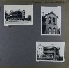
Album - Album page, Paynswicke, Gladstone Pde & Hartington St, Circa 1972
... surfaces and commanding aspect to the south-west. Its role for a period as home for local builder, Patrick Millane (compare no. 11 Gladstone Parade) is of interest. In 1889, a nine roomed brick house was in the course of erection on the site ...This photograph is part of the Caulfield Historical Album 1972. This album was created in approximately 1972 as part of a project by the Caulfield Historical Society to assist in identifying buildings worthy of preservation. The album is related to a Survey the Caulfield Historical Society developed in collaboration with the National Trust of Australia (Victoria) and Caulfield City Council to identify historic buildings within the City of Caulfield that warranted the protection of a National Trust Classification. Principal photographer thought to be Trevor Hart, member of Caulfield Historical Society. Most photographs were taken between 1966-1972 with a small number of photographs being older and from unknown sources. All photographs are black and white except where stated, with 386 photographs over 198 pages. House is commonly spelt as "Payneswicke".From: Glen Eira Heritage Management Plan (1996) by Andrew Ward and Associates "Payneswicke" is locally significant as a prominent and substantially intact villa of its period, distinguished by its cast cement enrichment, unpainted stuccoed surfaces and commanding aspect to the south-west. Its role for a period as home for local builder, Patrick Millane (compare no. 11 Gladstone Parade) is of interest. In 1889, a nine roomed brick house was in the course of erection on the site. The house was completed in 1890 and Millane took up residence. Millane continued as owner/ occupant in 1894. However, in 1899, although Millane still occupied the house, ownership had been taken over by the Land Mortgage Bank. By 1910, Andrew Brown was occupant. Occupancy passed to Edward Brown by 1920 and to Miss A.N. Brown by 1930. Miss Brown continued to live there in 1941.Page 50 of Photograph Album with three exterior photographs (2 landscape and 1 portrait) of Paynswicke, a double storey house.Hand written: No 13 [top right] / "Paynswicke" N.E. cnr Gladstone Pd & Hartington St [top right] / 8 Oct 1966 [under top left photo] / 50 [bottom right] trevor hart, 1880's, 1890's, payneswicke, patrick millane, gladstone parade, unpainted stuccoed surfaces, cast cement enrichment, hartington street, villa residence, italianate, elsternwick, victorian, mansion, cast iron verandahs, return verandahs, curved windows, full length windows, land mortgage bank, andrew brown, edward brown, a n brown, paynswicke -
 Bendigo Historical Society Inc.
Photograph - CENTRAL BLUE MINE, 1912
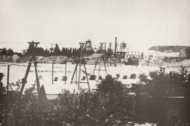
... History House 11 Mackenzie Street Bendigo goldfields MINE Gold central blue Bendigo mines and mining surface equipment place mining surface equipment flying fox poppet head Black and white photo: mine site with poppet head, mine buildings at rear right . ...Black and white photo: mine site with poppet head, mine buildings at rear right . Trestles and cables carrying rectangular bins across open land. Large mound of material behind main building. Trees and weatherboard building in foreground. On back written in ball point pen and underlined ' flying Fox' Central Blue Mine to Crushing Battery 1912 'mine, gold, central blue, bendigo, mines and mining, surface equipment, place, mining, surface equipment, flying fox, poppet head -
 Bendigo Historical Society Inc.
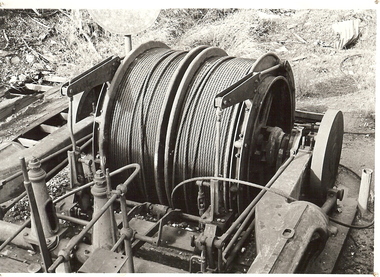
Photograph - WINDING ENGINE AT MONUMENT HILL MINE
... site...rope winding drum...Mines and mining... equipment... mining equipment... Bendigo... mines... mining... surface...History House 11 Mackenzie Street Bendigo goldfields PLACE Mining site rope winding drum Mines and mining equipment mining equipment Bendigo mines mining surface equipment Black and white photograph of a winding engine (Roberts & Son) at Monument Hill Mine. ...Black and white photograph of a winding engine (Roberts & Son) at Monument Hill Mine. Winding gear, large drum with wire cable wound on, sitting on concrete base. Inscriptions: on back - lined paper, glued in centre 'Monument Hill Mine, Winding Engine, Roberts and Sons'.place, mining site, rope winding drum, mines and mining, equipment, mining equipment, bendigo, mines, mining, surface equipment -
 Bendigo Historical Society Inc.
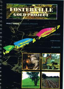
Document - FOSTERVILLE GOLD MINE COLLECTION: PROJECT UPGRADE TECHNICAL APPENDICES
... surface drainage study...noise emission to residential properties...flora survey...tailings dam site...Topics: hydro geological assessment; surface drainage study, noise emission to residential properties, flora survey, tailings dam site; flora survey Wellesford Forest; Daley's Hill Plant List; diurnal Avifauna Survey - Wellesford Forest; survey of vertebrate fauna - Wellesford Forest; brief summary of fauna - Daley's Hill, Axedale, Aboriginal Archaeological survey; archaeological investigation Fosterville; traffic survey - Fosterville Sulphide Project; traffic report....History House 11 Mackenzie Street Bendigo goldfields BENDIGO Mining Fosterville Gold Mine hydro geological assessment surface drainage study noise emission to residential properties flora survey tailings dam site flora survey Wellesford Forest Daley's Hill Plant List diurnal Avifauna Survey - Wellesford Forest survey of vertebrate fauna - Wellesford Forest brief summary of fauna - Daley's Hill Axedale Aboriginal Archaeological survey archaeological investigation Fosterville traffic survey - Fosterville Sulphide Project traffic report. ...Black cover book, wire binding. Pages in reports numbered individually, overall approx 250 page report. On front: "Fosterville Gold Project' Project upgrade, EES Technical Appendix B. Central North, Central Ellesmere, Harringtons Hill." Page 1 'Perseverance Exploration Pty Limited' Book contains technical appendices. Topics: hydro geological assessment; surface drainage study, noise emission to residential properties, flora survey, tailings dam site; flora survey Wellesford Forest; Daley's Hill Plant List; diurnal Avifauna Survey - Wellesford Forest; survey of vertebrate fauna - Wellesford Forest; brief summary of fauna - Daley's Hill, Axedale, Aboriginal Archaeological survey; archaeological investigation Fosterville; traffic survey - Fosterville Sulphide Project; traffic report.bendigo, mining, fosterville gold mine, hydro geological assessment, surface drainage study, noise emission to residential properties, flora survey, tailings dam site, flora survey wellesford forest, daley's hill plant list, diurnal avifauna survey - wellesford forest, survey of vertebrate fauna - wellesford forest, brief summary of fauna - daley's hill, axedale, aboriginal archaeological survey, archaeological investigation fosterville, traffic survey - fosterville sulphide project, traffic report. -
 Bendigo Historical Society Inc.
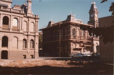
Photograph - LAW COURTS AND POST OFFICE BUILDING, BENDIGO
... Demolition site where Police Headquarters once stood in foreground, fully cleared with dirt surface evident. ...Demolition site where Police Headquarters once stood in foreground, fully cleared with dirt surface evident. ...Colour photo: taken from rear of Law Courts and Post Office buildings, which are situated in Pall Mall Bendigo. Demolition site where Police Headquarters once stood in foreground, fully cleared with dirt surface evident. Post Office building rear and side covered in scaffolding.organisation, government, law courts, post office -
 Bendigo Historical Society Inc.
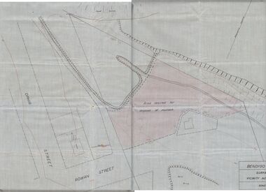
Plan - MCCOLL, RANKIN AND STANISTREET COLLECTION: PLAN OF MONUMENT HILL BATTERY
... Written on back of plan ' Monument Hill Battery site, area desired by Bendigo Mines (Nell Gwynne) for disposal of mullock. Plan shows Ophir Street, Rowan Street, Written on bottom RH corner 'Bendigo Mines Ltd., surface plan, vicinity Nell Gwynne Shaft, Scale 1" = 40' Magnetic north marked, sand dumps and contour lines....Written on back of plan ' Monument Hill Battery site, area desired by Bendigo Mines (Nell Gwynne) for disposal of mullock. Plan shows Ophir Street, Rowan Street, Written on bottom RH corner 'Bendigo Mines Ltd., surface plan, vicinity Nell Gwynne Shaft, Scale 1" = 40' Magnetic north marked, sand dumps and contour lines. ...Pale blue waxed paper plan. Written on back of plan ' Monument Hill Battery site, area desired by Bendigo Mines (Nell Gwynne) for disposal of mullock. Plan shows Ophir Street, Rowan Street, Written on bottom RH corner 'Bendigo Mines Ltd., surface plan, vicinity Nell Gwynne Shaft, Scale 1" = 40' Magnetic north marked, sand dumps and contour lines.bendigo, business, mccoll, rankin & stanistreet -
 The Beechworth Burke Museum
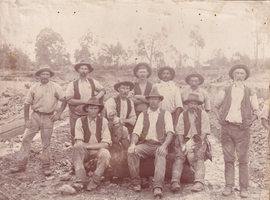
Photograph, c. 1870
... surface alluvial gold had already been discovered and removed. This heavy machinery was not used until after 1853. The search for gold is ingrained into the history of Victoria and therefore, images like this one which portray an open cut sluicing site can reveal important information for society and technology for the date when the photograph was taken. ...This photograph was captured at an undisclosed location and at an unidentified time but likely dates to approximately 1870. The photographer's details are not recorded and the identities of the men in the image are also not known. This image depicts a group of 10 men in typical miners fashion. Four of them are sat on a large log with one holding a small dog. Six miners stand behind those sitting. All these men are wearing a white button-up shirt and tan coloured work trousers. They wear heavy boots and seven have included a dark vest over their shirt. The man holding the dog has a pipe in his mouth. Two of these men are clean shaven with the remainder sporting a moustache and two with a beard. The ages of these men vary from late 20s to middle age. This group of men are located in a mining location with what appears to be an open cut mine in the background of the image. The ground is muddy and has elements which can help identify it as a mining location based on the condition of the landscape. The bottom of the men's trousers are muddy which provides the assurance that these men were working in this location when their photograph was captured. In the background there is one structure, possibly a dwelling, and bush which identifies the location as Australia. Open cut sluicing is a method used to extract gold and other precious metals from beneath the surface of the earth. This technique involved the use of high-powered hoses which broke down the soil enabling miners to come along and search this soil for gold. After the gold rush of the early 1850s, diggers had to enlist the assistance of heavy machinery and techniques like hydraulic sluicing in order to reach gold because the surface alluvial gold had already been discovered and removed. This heavy machinery was not used until after 1853. The search for gold is ingrained into the history of Victoria and therefore, images like this one which portray an open cut sluicing site can reveal important information for society and technology for the date when the photograph was taken. This image is of important historical significance for its ability to convey information about sluicing and the methods used to find gold in the late 1800s and early 1900s. It also shows a location where sluicing was undertook which provides insight into the impact of sluicing on the environment at a time when it was done. Images, like this one, of Australian gold rush history can reveal important information about the social and environmental impact of this period. This image depicts diggers standing in a mining location and therefore, this image has the capacity to reveal or support significant information for researchers studying the fashion and social status of diggers in Australia in approximately 1870. It can also provide information on the landscape of Australia in this period and the impact of mining for gold on both society and the Australian landscape. The Burke Museum is home to a substantial collection of Australian mining photographs which can be used to gain a deeper understanding into life on the gold fields, technology used in mining, the miners themselves and the impact of the gold digging on the environment.Sepia toned rectangular photograph printed on matte photographic paper mounted on board.Reverse: 1997.2518mining, goldfields, beechworth, 1870, australia, australian goldfields, diggers, victoria, sluicing, gold mining, miners, diggers victoria -
 The Beechworth Burke Museum
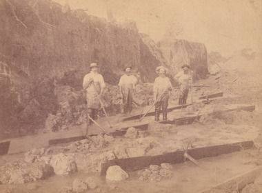
Photograph, c.1870
... After the gold rush of the early 1850s, diggers had to enlist the assistance of heavy machinery and techniques like hydraulic sluicing in order to reach gold because the surface alluvial gold had already been discovered and removed. This heavy machinery was not used until after 1853. The Three Mile Goldfields was a site...After the gold rush of the early 1850s, diggers had to enlist the assistance of heavy machinery and techniques like hydraulic sluicing in order to reach gold because the surface alluvial gold had already been discovered and removed. This heavy machinery was not used until after 1853. The Three Mile Goldfields was a site ...This photograph was taken in approximately 1870 and depicts four male miners standing in mining sluice at the Three Mile Goldfields. These men are wearing typical attire for 1870s gold miners. They wear white shirts, tan coloured pants with water proof shoes and most of the men are wearing an apron to prevent their clothing from becoming too dirty from the mud. Each man is wearing a wide brim hat and hold large wooden tools used for sorting through the sluice. Three of the four men have full beards. The photograph was donated to the Burke Museum by R. Ziegenbein before 2001 but the photographer and the individuals captured in the photo are unknown. The image depicts the landscape of the Three Mile Goldfields during a period when open cut sluicing was undertaken to reach gold. Open cut sluicing is a method used to extract gold and other precious metals from beneath the surface of the earth. This technique involved the use of high-powered hoses which broke down the soil enabling miners to come along and search this soil for gold. After the gold rush of the early 1850s, diggers had to enlist the assistance of heavy machinery and techniques like hydraulic sluicing in order to reach gold because the surface alluvial gold had already been discovered and removed. This heavy machinery was not used until after 1853. The Three Mile Goldfields was a site of rich alluvial gold deposits located about 5 km south of Beechworth in Victoria. Today, the location of this gold deposit is called Baarmutha. It was a popular area for gold mining in the 1850s but became largely abandoned by the following decade. In 1865, a man named John Pund recognized that the area could be potentially rich if a better water supply could be obtained. He secured a 15 year license with three other miners. Within the next five years, these men had constructed 19 km of water race going from Upper Nine Mile Creek to Three Mile Creek. By 1881, these four men had delivered 950,000 gallons to the Three Mile Sluicing area which is depicted in this photograph. Pund was later go into partnership with John Alston Wallace who would become owner of the Star Hotel in Beechworth. The Three Mile sluicing location continued to be operational until 1950. Sluice box workers were a vital part of gold mining regardless of how inefficient they were in the recovery of gold. After using hydraulic sluicing to cut away the earth, miners would use the big wooden boxes depicted in the image to catch the earth which would then be sifted for gold. However, accidents would occur often which would result in the gold washing away and unable to be recovered. It was not a very efficient system because the gold, which was alluvial and thus very fine, would often pass through the sluice box undetected.The search for gold is ingrained into the history of Victoria and therefore, images like this one which portray an open cut sluicing site can reveal important information for society and technology for the date when the photograph was taken. This image is of important historical significance for its ability to convey information about sluicing and the methods used to find gold in the late 1800s and early 1900s. It also shows a location where sluicing was undertook which provides insight into the impact of sluicing on the environment at a time when it was done. Images, like this one, of Australian gold rush history can reveal important information about the social and environmental impact of this period. This image depicts diggers standing in a mining location and therefore, this image has the capacity to reveal or support significant information for researchers studying the fashion and social status of diggers in Australia in approximately 1870. It can also provide information on the landscape of Australia in this period and the impact of mining for gold on both society and the Australian landscape. The Burke Museum is home to a substantial collection of Australian mining photographs which can be used to gain a deeper understanding into life on the gold fields, technology used in mining, the miners themselves and the impact of the gold digging on the environment.Sepia toned rectangular photograph printed on matte photographic paper and mounted on board.[illegible] about 1870 / 97 2514.1 / 2594 30three mile goldfields, goldfields, 1870, 1870 gold, australia, australian landscape, miners, gold miners, diggers, gold diggers, beechworth, victoria, sluice box workers, sluicing, sluice, mining -
 The Beechworth Burke Museum
Photograph, 1960s
... sites with electricity outlets, a large single-story building with a caravan park banner, dirt roads, a freestanding message board, and a parked car. Lake Sambell Caravan Park opened in 1959 owing to the work of R.E. Carter, Beechworth Shire engineer from 1954-63. Carter advocated for improvements to the lake and surrounding area in order to encourage tourism in Beechworth. The opening of the caravan park was part of many improvements to Lake Sambell made in this period by Carter including: the swimming pool in 1961, water skiing and boating facilities, and increased lake surface...sites with electricity outlets, a large single-story building with a caravan park banner, dirt roads, a freestanding message board, and a parked car. Lake Sambell Caravan Park opened in 1959 owing to the work of R.E. Carter, Beechworth Shire engineer from 1954-63. Carter advocated for improvements to the lake and surrounding area in order to encourage tourism in Beechworth. The opening of the caravan park was part of many improvements to Lake Sambell made in this period by Carter including: the swimming pool in 1961, water skiing and boating facilities, and increased lake surface ...This photograph was taken in the 1960s at Lake Sambell Caravan Park and visible in the photograph are individual caravan sites with electricity outlets, a large single-story building with a caravan park banner, dirt roads, a freestanding message board, and a parked car. Lake Sambell Caravan Park opened in 1959 owing to the work of R.E. Carter, Beechworth Shire engineer from 1954-63. Carter advocated for improvements to the lake and surrounding area in order to encourage tourism in Beechworth. The opening of the caravan park was part of many improvements to Lake Sambell made in this period by Carter including: the swimming pool in 1961, water skiing and boating facilities, and increased lake surface in 1964. These improvements were financed mainly by grants from the Tourist Development Authority. The popularity of caravanning in Australia exploded during this post-war period of the late 1950s and 1960s. This popularity was driven by multiple factors, including: the stopping of fuel rations, the accessibility of car ownership through the manufacturing of affordable cars, technological developments in caravan design, and the increase in prosperity and leisure time for many Australians. Facilities such as electrical outlets to power caravans are present in this photograph of Lake Sambell Caravan Park. Lake Sambell is an artificial lake that was developed on the previous site of the Rocky Mountain Mining Company workings and was officially opened by Minister for Lands, Mr Baily, on October 5, 1928. The disused and unattractive remains of the mine were converted into a recreational area intended for swimming, boating, and fishing. The lake is named after Mr L.H. Sambell, shire engineer and secretary of the Forward Beechworth Committee, who advocated for the enhancement of Beechworth into a tourist destination and was central to the planning and establishment of the lake. This photograph is of historical and social significance in providing insight into caravanning during the 1960s in Australia. Caravanning was extremely popular during the 1960s in Australia due to multiple social and economic factors including the stopping of fuel rations, the accessibility of car ownership through the manufacturing of affordable cars, technological developments in caravan design, and the increase in prosperity and leisure time for many Australians.Black and white rectangle photograph printed on photographic paper and unmounted.Reverse: 3536/ [logo back printing: KODAK/ VELOX/ PAPER] / C798 lake sambell caravan park, lake sambell, caravanning 1960s, caravan park, rocky mountain mining company, kodak velox paper, r.e. carter, l.h. sambell, caravan electricity outlets, tourist development authority, post-war prosperity, forward beechworth committee, lake sambell boating, lake sambell swimming pool, lake sambell fishing, artificial lake, travel 1960s, recreation 1960s -
 The Beechworth Burke Museum
Photograph, 1960s
... sites with electricity outlets, a large single-story building, a parked car, and two caravans partially obstructed by trees. Lake Sambell Caravan Park opened in 1959 owing to the work of R.E. Carter, Beechworth Shire engineer from 1954-63. Carter advocated for improvements to the lake and surrounding area in order to encourage tourism in Beechworth. The opening of the caravan park was part of many improvements to Lake Sambell made in this period by Carter including: the swimming pool in 1961, water skiing and boating facilities, and increased lake surface...sites with electricity outlets, a large single-story building, a parked car, and two caravans partially obstructed by trees. Lake Sambell Caravan Park opened in 1959 owing to the work of R.E. Carter, Beechworth Shire engineer from 1954-63. Carter advocated for improvements to the lake and surrounding area in order to encourage tourism in Beechworth. The opening of the caravan park was part of many improvements to Lake Sambell made in this period by Carter including: the swimming pool in 1961, water skiing and boating facilities, and increased lake surface ...This photograph was taken in the 1960s at Lake Sambell Caravan Park, visible in the photograph are individual caravan sites with electricity outlets, a large single-story building, a parked car, and two caravans partially obstructed by trees. Lake Sambell Caravan Park opened in 1959 owing to the work of R.E. Carter, Beechworth Shire engineer from 1954-63. Carter advocated for improvements to the lake and surrounding area in order to encourage tourism in Beechworth. The opening of the caravan park was part of many improvements to Lake Sambell made in this period by Carter including: the swimming pool in 1961, water skiing and boating facilities, and increased lake surface in 1964. These improvements were financed mainly by grants from the Tourist Development Authority. The popularity of caravanning in Australia exploded during this post-war period of the late 1950s and 1960s. This popularity was driven by multiple factors, including: the stopping of fuel rations, the accessibility of car ownership through the manufacturing of affordable cars, technological developments in caravan design, and the increase in prosperity and leisure time for many Australians. Facilities such as electrical outlets to power caravans are present in this photograph of Lake Sambell Caravan Park. Lake Sambell is an artificial lake that was developed on the previous site of the Rocky Mountain Mining Company workings and was officially opened by Minister for Lands, Mr Baily, on October 5, 1928. The disused and unattractive remains of the mine were converted into a recreational area intended for swimming, boating, and fishing. The lake is named after Mr L.H. Sambell, shire engineer and secretary of the Forward Beechworth Committee, who advocated for the enhancement of Beechworth into a tourist destination and was central to the planning and establishment of the lake. This photograph is of historic and social significance in documenting the enhancement of the Lake Sambell area overseen by R.E. Carter and providing insight into caravanning during the 1960s in Australia. Caravanning was extremely popular in Australia during the late 1950s and 60s due to multiple social and economic factors including the stopping of fuel rations, the accessibility of car ownership through the manufacturing of affordable cars, technological developments in caravan design, and the increase in prosperity and leisure time for many Australians. Black and white rectangle photograph printed on photographic paper and unmounted.Reverse: 3538/ [logo back printing KODAK/ VELOX/ PAPER] / C798lake sambell caravan park, lake sambell, lake sambell 1960s, lake sambell fishing, lake sambell boating, lake sambell swimming pool, r.e. carter, l.h. sambell, tourist development authority, caravanning 1960s, caravan electricity outlets, caravan park, forward beechworth committee, rocky mountain mining company, lake caravan park, caravan mid 20th century, beechworth tourism, travel in the 1960s, holiday 1960s -
 The Beechworth Burke Museum
Photograph, 1920-1950
... Alluvial, or surface, mining began on this site in the 1850s, but was soon replaced by hydraulic sluicing methods. ...Alluvial, or surface, mining began on this site in the 1850s, but was soon replaced by hydraulic sluicing methods. ...This image taken between 1920-1930 depicts open-cut hydraulic sluicing at the Three Mile Mine, located about five kilometres south of Beechworth. Alluvial, or surface, mining began on this site in the 1850s, but was soon replaced by hydraulic sluicing methods. By the start of 1880 it is estimated that nine hundred miles of water races had been cut though soil and rock in the Beechworth district. Hydraulic sluicing employs high pressure jets of water to blast away large areas of earth and wash it down to be run through a sluice box. Gold gets caught in the sluice and the remaining slurry is washed away. Large water quantities were required for hydraulic sluicing, and the long water races and deep tailraces that were constructed were considered great engineering feats. This method of mining is extremely effective, but causes significant environmental damage and impacts to waterways and agricultural operations. Miners at Beechworth built extensive networks of races and dams to secure reliable supplies of water on a scale far greater than elsewhere in Victoria. By the 1880s Beechworth's water barons continued to hold more than half of all the water right licences on issue and undertook sluicing operations on a massive scale. The manipulation of surface and ground water via race networks was well planned and recorded in detail by local mining surveyors. The maps that were created, combined with modern geo-spatial technologies, provide a vital key in understanding the great lengths to which miners went to capture and control critical water resources. Today, Three Mile mine is called Baarmutha. The Three Mile Mine was unproductive until 1865 when John Pund and three other miners secured a fifteen year license and constructed a water race from Upper Nine Mile Creek to Three Mile Creek. In the early twentieth century Pund & Co. averaged over one thousand ounces of gold per year from the mine. After Pund's death in 1915, GSG Amalgamated Co operated the site, continuing sluicing until 1950. This image of hydraulic sluicing methods shows the extent of water-works engineering in the landscape. This photograph has historic and research potential for understanding changes to the landscape, the evolution of mining methods, and the extensive construction, manipulation and management of water networks in the Beechworth district. Black and white rectangular photograph on matte paperReverse: 7597-1 / Sluice Mining / Copied from original on loan from Webb (Qld) / Donated Nov 2009 / Baarmutha Three Mile Mine c1920-1950 / Managed by the Plain Bros then Parkinsons / Current Location is: Beechworth Animal Shelter / used for Baarmuthaburke museum, beechworth museum, beechworth, gold fields, gold rush, victorian gold rush, hydraulic sluicing, spring creek, netwown falls, mining tunnels, water races, tailraces, gold ming history, colonial australia, australian gold rushes, mining technology, beechworth historic district, indigo gold trail, indigo shire, john pund, water manipulation, water engineering, three mile creek, three mile mine, water race, large-scale mining methods, historical mining construction, alluvial mining, mining environmental impacts, baarmutha, water barons -
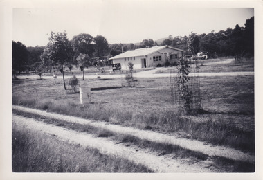
![Photograph - Digital image, Kelly Garden Supplies [Greensborough], 02/05/2013](/media/collectors/4f729f5697f83e03086015b8/items/5729bced2162f108e8de6b52/item-media/5729bd212162f108e8de74aa/item-fit-380x285.jpg?cb=6) Greensborough Historical Society
Greensborough Historical SocietyPhotograph - Digital image, Kelly Garden Supplies [Greensborough], 02/05/2013
... site is now part of the Civic roundabout at the top of the Greensborough By-pass. Civic Drive was associated with the building of Diamond Valley Council Offices opened by Governor Rohan Delacombe on 26/2/1972. Previously it was known as Kelly's Track which wound its way around to a house that overlooked the aqueduct bridge. Kelly's Sandpit (quarry) was the local go to place to obtain road, driveway fill and red sand for local construction. For 80 years previous Kelly's quarry supplied sand to the greater Melbourne area for the surfacing...site is now part of the Civic roundabout at the top of the Greensborough By-pass. Civic Drive was associated with the building of Diamond Valley Council Offices opened by Governor Rohan Delacombe on 26/2/1972. Previously it was known as Kelly's Track which wound its way around to a house that overlooked the aqueduct bridge. Kelly's Sandpit (quarry) was the local go to place to obtain road, driveway fill and red sand for local construction. For 80 years previous Kelly's quarry supplied sand to the greater Melbourne area for the surfacing ...This photograph of the former site of Kelly Garden Supplies was taken in 2013 to show changes over 40 years, based on Ron Reynold’s sketches in the 1973 publication “Greensborough and Greenhills” published by Cypress Books. The site is now part of the Civic roundabout at the top of the Greensborough By-pass. Civic Drive was associated with the building of Diamond Valley Council Offices opened by Governor Rohan Delacombe on 26/2/1972. Previously it was known as Kelly's Track which wound its way around to a house that overlooked the aqueduct bridge. Kelly's Sandpit (quarry) was the local go to place to obtain road, driveway fill and red sand for local construction. For 80 years previous Kelly's quarry supplied sand to the greater Melbourne area for the surfacing of school grounds, parks etc. Digital copy of colour photograph.greensborough and greenhills, civic drive greensborough, kelly garden supplies, ron reynolds -
 Greensborough Historical Society
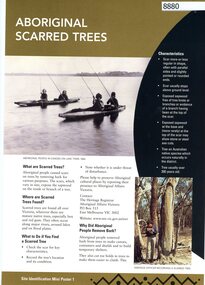
Poster, Victoria. Department of Natural Resources and Environment, Site identification mini poster (#1-2, 4-6, 8-10, 13-14), 2002
... Mini poster 1: Aboriginal scarred trees; 2 Aboriginal mounds; [3 missing]; 4 Aboriginal flaked stone tools; 5 Aboriginal burials; 6 Aboriginal surface scatters; [7 missing]; 8 Aboriginal ground-edge axes; 9 Aboriginal grinding stones; 10 Aboriginal stone arrangements; [11 missing]; 12 Aboriginal axe-grinding grooves; 13 Aboriginal coastal shell middens; 14 Aboriginal rock art. aborigines - victoria aboriginal affairs victoria 11 parts of incomplete set, each two sided, text and photographs Site identification mini poster (#1-2, 4-6, 8-10, 13-14) Poster Poster Victoria. ...This set produced by the Victorian Department of Natural Resources and Environ met and Aboriginal Affairs Victoria. Mini poster 1: Aboriginal scarred trees; 2 Aboriginal mounds; [3 missing]; 4 Aboriginal flaked stone tools; 5 Aboriginal burials; 6 Aboriginal surface scatters; [7 missing]; 8 Aboriginal ground-edge axes; 9 Aboriginal grinding stones; 10 Aboriginal stone arrangements; [11 missing]; 12 Aboriginal axe-grinding grooves; 13 Aboriginal coastal shell middens; 14 Aboriginal rock art.11 parts of incomplete set, each two sided, text and photographsaborigines - victoria, aboriginal affairs victoria