Showing 666 items matching "survey plan"
-
 University of Melbourne, Burnley Campus Archives
Work on paper (item) - Survey Plan, Thomas and George Licensed Surveyors, Partial Feature Survey Plan 125 Dee Road Millgrove 3799, 25th February, 2014
... Survey Plan...Partial Feature Survey Plan 125 Dee Road Millgrove 3799...survey plan...A sheet of paper on which a partial feature survey plan... on the 24th February 2014. 125 Dee Road Millgrove survey plan A sheet ...Prepared for building and landscape design purposes. It was created by a company called 'Thomas and George Licensed Surveyors' and the survey was conducted on the 24th February 2014. 125 dee road, millgrove, survey plan -
 Kew Historical Society Inc
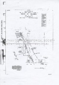
Plan, Survey Plan, Park Hill Road, Kew, 1880-1890
... Survey Plan, Park Hill Road, Kew...The streets identified on the survey plan - Cotham Road...Hand drawn and coloured survey plan created by Holland... The streets identified on the survey plan - Cotham Road, Park Hill ...The streets identified on the survey plan - Cotham Road, Park Hill Road East, Park Hill Road West in Kew were each gazetted by the Victorian Government in 1865. The hand-coloured survey plan was completed by Holland Loxton, Town Clerk and Surveyor of the Borough of Kew from 1866. The unnamed survey plan includes names of land owners in addition to measurements (2 chains to 1 inch) and streets. Named owners include Webster, Payne and Francom which will enable us to narrow down the creation date of the survey.Handdrawn survey plan by a former surveyor and town clerk of KewHand drawn and coloured survey plan created by Holland Loxton, Surveyor and Town Clerk of Kew, showing land owned by Payne in Park Hill Road, Kew. The plan includes street names, land measurements and land owners.surveys - kew, maps - kew, holland loxton, park hill road - kew, holland loxton -- surveyor, survey plans -- parkhill road -- kew (vic.) -
 Eltham District Historical Society Inc
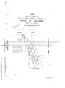
Document - Survey Plan, Country Roads Board, SP 6801, Eltham-Yarra Glen Road; Brougham St to Bridge St, 1958
... Survey Plan...Survey Plan...1958 C.R.B. Plan of Survey of Part of Crown Portion 12... melbourne 1958 C.R.B. Plan of Survey of Part of Crown Portion 12 ...1958 C.R.B. Plan of Survey of Part of Crown Portion 12 Section 4 Parish of Nillumbik, County of Evelyn Eltham-Yarra Glen Road, Shire of Eltham Shows Surveyor field notes, property ownership and building type and construction.a.j. collis, a.s. & c.g.h. fitzpatrick, board of land & works, bridge street, brougham steet, commonwealth bank of australia, country roads board, eltham, eltham rsl sub-branch, f.h. collis, f.m. smith, f.n. & e.j. burgoyne, franklin street, h.c. & r.e. burgoyne, j. jorgenson, j.f. & j.e. morris, j.n. & h.c. burgoyne, j.s. blow, john street, main road, p.e. smith, pitt street, r.j. dripps, s.j. taylor, survey plan, trustees of the eltham methodist church, 1958, eltham-yarra glen road, neil webster collection -
 Eltham District Historical Society Inc
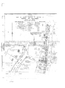
Document - Survey Plan, Country Roads Board, SP 6802, Eltham-Yarra Glen Road; Brougham St to Dalton St, 1958
... Survey Plan...Survey Plan...1958 C.R.B. Plan of Survey of Part of Crown Portion 12... melbourne 1958 C.R.B. Plan of Survey of Part of Crown Portion 12 ...1958 C.R.B. Plan of Survey of Part of Crown Portion 12 Section 4 Parish of Nillumbik, County of Evelyn Eltham-Yarra Glen Road, Shire of Eltham Shows Surveyor field notes, property ownership and building type and construction.1958, eltham-yarra glen road, a.f. munday, bible street, brougham steet, country roads board, dalton street, eltham, j.p. & e.a. sanders, j.w. & e. m. graham, l.c. skipper, l.m. jarrold, main road, napoleon street, survey plan, neil webster collection, franco and co -
 Eltham District Historical Society Inc
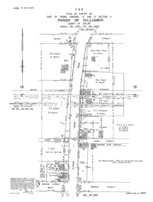
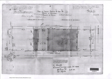
Document - Survey Plan, Country Roads Board, SP 6313, Eltham-Yarra Glen Road; Luck St to Henry St, 1956
... Survey Plan...Survey Plan...1956 C.R.B. Plan of Survey of Part of Crown Portion 13... melbourne 1956 C.R.B. Plan of Survey of Part of Crown Portion 13 ...1956 C.R.B. Plan of Survey of Part of Crown Portion 13 Section 4 Parish of Nillumbik, County of Evelyn Eltham-Yarra Glen Road, Shire of Eltham Shows Surveyor field notes, property ownership and building type and construction.eltham-yarra glen road, country roads board, eltham, main road, survey plan, 1956, a.l. lyon, a.w. brinkkotter, arthur street, c.r. burkett, dudley street, e.n. staff, eltham war memorial trust, henry street, luck street, pryor street, the board of land & works, the equity trustees executors and agency coy ltd, the roman catholic trusts corporation, victorian railways commision, neil webster collection -
 Eltham District Historical Society Inc
Document - Survey Plan, Country Roads Board, SP 6800, Eltham-Yarra Glen Road; Bridge St to Henry St, 1958
... Survey Plan...Survey Plan...1958 C.R.B. Plan of Survey of Part of Crown Portions 12... melbourne 1958 C.R.B. Plan of Survey of Part of Crown Portions 12 ...1958 C.R.B. Plan of Survey of Part of Crown Portions 12 and 13 Section 4 Parish of Nillumbik, County of Evelyn Eltham-Yarra Glen Road., Shire of Eltham Shows Surveyor field notes, property ownership and building type and construction.1958, a.m. gahan, a.s & s.j. davis, annie ellen davies, bridge street, country roads board, d.a. lyon, dave lyon, eltham, flora towell, g.e. gallagher, henry street, j. lyon, k. greene, main road, p.a. gahan, survey plan, w.l. chynoweth pty ltd, york street, neil webster collection -
 Eltham District Historical Society Inc
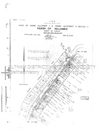
Document - Survey Plan, Country Roads Board, SP 6561, Eltham-Yarra Glen Road; Park Rd to Bellevue Rd, 1957
... Survey Plan...Survey Plan...1957 C.R.B. Plan of Survey of Parts of Crown Allotment 1... melbourne 1957 C.R.B. Plan of Survey of Parts of Crown Allotment 1 ...1957 C.R.B. Plan of Survey of Parts of Crown Allotment 1 & Crown Allotment F, Section II Parish of Nillumbik, County of Evelyn Eltham-Yarra Glen Road, Shire of Eltham Shows Surveyor field notes, property ownership and building type and construction.eltham-yarra glen road, country roads board, eltham, main road, survey plan, 1957, a.r. thomas, b. & b.d. hearn, b.g. anderson, bellevue road, e.m. pitts, f.a. m. macrae, g.e. & b. moulder, j. bromley, j.m. & s.g. johnstone, k.f. pitts, l.c. docksey, m. & e.c.w. baart, m.p. bromley, n.r. ord, p.j. & g.e. murphy, park road, r.a. bruce, r.a. macbeth, r.w. shearing, railway road, s.e. & y.p. houghton, w.k. bell, w.s.r. & f.n. toley, neil webster collection -
 Eltham District Historical Society Inc
Document - Survey Plan, Country Roads Board, SP 6559-6560, Eltham-Yarra Glen Road; Elsa Ct to Luck St, 1957
... Survey Plan...Survey Plan...1957 C.R.B. Plan of Survey of Part of Crown Portion 13... melbourne 1957 C.R.B. Plan of Survey of Part of Crown Portion 13 ...1957 C.R.B. Plan of Survey of Part of Crown Portion 13 Section 4 and Crown Allotment 1 Section 1 Parish of Nillumbik, County of Evelyn Eltham-Yarra Glen Road, Shire of Eltham Shows Surveyor field notes, property ownership and building type and construction.eltham-yarra glen road, country roads board, eltham, main road, survey plan, 1957, a.m. & a.a. iowerson, a.mcg. hepburn, cecil street, coffee lounge, diamond street, e.g. murrell, elsa court, h.b. woodhead, j.c. & s.i. harding, la ronde, luck street, r.m. & v.m. white, r.n. mowatt, the board of land & works, w.g. hains, neil webster collection -
 Eltham District Historical Society Inc
Document - Survey Plan, Country Roads Board et al, SP 12272A, Eltham-Yarra Glen Road; Brougham St to Dalton St, 1970-1976
... Survey Plan...Survey Plan...1970 C.R.B. Plan of Survey of Part of Crown Portion 12...1970 C.R.B. Plan of Survey of Part of Crown Portion 12 ...1970 C.R.B. Plan of Survey of Part of Crown Portion 12 Section 4 Parish of Nillumbik, County of Evelyn Eltham-Yarra Glen Road, Shire of Eltham Shows Surveyor field notes, property ownership and building type and construction. John L. Roberts, Licensed Surveyor as noted 4 June 1970 Amendments in black by John L. Roberts, L.S. 20-12-76 See also EDHS_05783 (1958)eltham-yarra glen road, 1970, 1976, a.f. munday, brougham street, dalton street, eltham, eltham clinic, g.t. & e.a. donnelly, jarrold cottage, l.m. jarrold, m.s.m. skipper, main road eltham, map, maria street, matcham skipper, mobil service centre (eltham), mobil service station, napoleon street, survey plan, white cloud cottage, country roads board -
 Bendigo Historical Society Inc.
Document - SURVEY PLAN OF HARGREAVES & HOPETOWN STREETS
... SURVEY PLAN OF HARGREAVES & HOPETOWN STREETS...Undated survey plan by William Bockli, Consulting Engineer... BENDIGO Industry hanro knitting mill Undated survey plan ...Undated survey plan by William Bockli, Consulting Engineer 422-428 Collins St Melbourne showing land between Hargreaves St and Hopetoun St Bendigo, stamped 'Hanro Aust Bendigo Knitting Mill, PTY,LTD., Job 37, drawing No 8. Scale . 30 feet to an inch. Unknown donorbendigo, industry, hanro knitting mill -
 Friends of Ballarat Botanical Gardens History Group
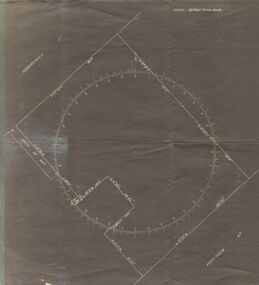
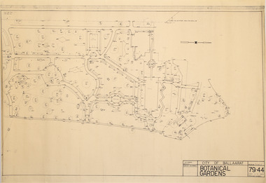
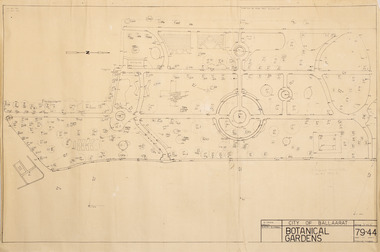
Plan - Survey Plan A, G. Creek, City of Ballarat Botanical Gardens
... Survey Plan A ... Plan Survey Plan A G. Creek ...HistoricSurvey map on papersurvey map, city of ballaarat, ballarat botanical gardens -
 Friends of Ballarat Botanical Gardens History Group
Plan - Survey Plan A, G. Creek, City of Ballarat Botanical Gardens
... Survey Plan A ... Plan Survey Plan A G. Creek ...HistoricSurvey map on papersurvey map, city of ballaarat, ballarat botanical gardens -
University of Melbourne, Burnley Campus Archives
Plan, "Invergowrie" Tree Survey Plan, 1989
... "Invergowrie" Tree Survey Plan.... "Invergowrie" Tree Survey Plan Plan ...Dyeline plan drawn by W. Klein. Numbered trees with position in garden. Dated 03.03.1989.invergowrie, w. klein -
Whitehorse Historical Society Inc.
Map, Burwood Road, Box Hill City, 15/02/1952 12:00:00 AM
... as Survey Plan No 5441.... between Milford Avenue and Station Street. Marked as Survey Plan.... Marked as Survey Plan No 5441. Land Subdivision Burwood Road ...Plan of subdivision of ten blocks in Burwood Road, Burwood.Plan of subdivision of ten blocks in Burwood Road, Burwood between Milford Avenue and Station Street. Marked as Survey Plan No 5441.Plan of subdivision of ten blocks in Burwood Road, Burwood. land subdivision, burwood road, burwood, milford avenue, burwood, central court, burwood -
Whitehorse Historical Society Inc.
Map, Burwood Road, Box Hill City, 15/02/1952 12:00:00 AM
... as Survey Plan No 5442....Plan of subdivision of 19 blocks in Burwood Road, Burwood.... Marked as Survey Plan No 5442. Land Subdivision Burwood Road ...Plan of subdivision of 19 blocks in Burwood Road, Burwood.Plan of subdivision of 19 blocks in Burwood Road, Burwood between Greenwood Street and Middleborough Road. Marked as Survey Plan No 5442.Plan of subdivision of 19 blocks in Burwood Road, Burwood. land subdivision, burwood road, burwood, greenwood street, burwood, middleborough road, burwood -
 University of Melbourne, Burnley Campus Archives
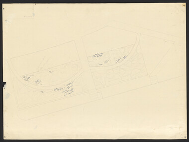
Plan, Plan Survey Perennial Border and environs and Spring Display, 1982-1990
... Plan Survey Perennial Border and environs and Spring..., VCAH Burnley Plan Survey: Perennial Border and Environs, dated... Burnley Plan Survey: Perennial Border and Environs, dated 8.11.90 ...(1) Tracing paper plan of bed. (2) Perennial Border Spring Display Planted 1982, plantings numbered but no names. (3) Pencil on paper, names of plants, some in pen. Area now known as the Grey Garden. Old Storage Shed cleared in 1979. (4) Tracing paper copy, VCAH Burnley Plan Survey: Perennial Border and Environs, dated 8.11.90. Scale 1:100. This might be where the Herbaceous Border is in 2012. (Also see 11.0615).gardens, vcah burnley, perennial border, spring flowers -
Port Melbourne Historical & Preservation Society
Plan - Plan Port Melbourne Town Hall, c.2024
... Port Melbourne Town Hall Survey Plan...Port Melbourne Town Hall Port Melbourne Town Hall Survey ...Port Melbourne Town Hall Survey Planport melbourne town hall -
Glen Eira Historical Society
Plan - Warrigal Road, Oakleigh
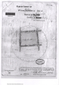
... Survey Plan... valuation of land for proposed widening of Warrigal Road. A plan... of Warrigal Road. A plan of Survey, no.5474, for Crown portion ...Documents about a small portion of land on Warrigal Road Oakleigh, now Oakleigh East. A Letter dated 29/05/1952 from Gas and Fuel Corporation of Victoria to Mr. L.P. Simmonds requesting valuation of land for proposed widening of Warrigal Road. A plan of Survey, no.5474, for Crown portion of Parish of Moorabbin and Parish of Mordialloc for owner The Brighton Gas Coy Ltd. New Street Brighton. Mortgages to the National Mutual Life Association. A letter dated 04/06/1952 from Gas and Fuel Corporation of Victoria in reference to Warrigal Road and Centre Road from the Country Roads Board who desire to acquire the land. Handwritten calculation notes and price for valuation, most likely as an attachment to the letter dated 04/06/1952.gas and fuel corporation, warrigal road, centre road, moorabbin council, simmonds l.p, survey plan, county of bourke, the brighton gas company ltd., country roads board, the national mutual life association of australia ltd., bentleigh east -
 Melbourne Tram Museum
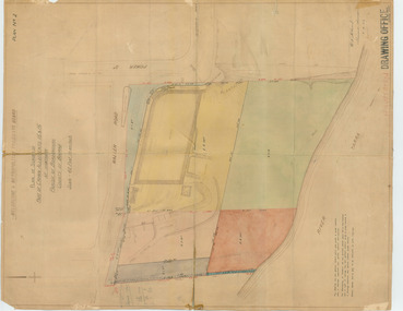
Drawing, "Plan of Survey of Part of Crown Allotments 15 and 16 at Hawthorn, Parish of Boroondara, County of Bourke", 1922
... "Plan of Survey of Part of Crown Allotments 15 and 16 at... "Plan of Survey of Part of Crown Allotments 15 and 16... drawing wash, titled "Plan of Survey of Part of Crown Allotments ...Drawing, coloured with water based drawing wash, titled "Plan of Survey of Part of Crown Allotments 15 and 16 at Hawthorn, Parish of Boroondara, County of Bourke". Shows the tram track, Wallen Road, changes around the intersection with Power St, buildings. A note at the bottom notes who owns what - MMTB and City of Hawthorn. Prepared by H. S. McComb, licensed Surveyor 6-9-1922. Stored folded.Stamped "Drawing Office" "Office Copy" and in red pencil "Hawthorn" in the bottom right hand corner, and on the rear "Drawing Office" "Office Copy" and "Hawthorn Depot" in pencil.trams, tramways, htt, mmtb, hawthorn depot, plans -
 Ringwood and District Historical Society
Article - Newspaper Clipping, Land Sale Advertisements, Golden Hill Estate, Ringwood - 1965, 1966, and Plan of Survey of Lot 8, Mullum Mullum Road Ringwood, 1970
... - 1965, 1966, and Plan of Survey of Lot 8, Mullum Mullum Road... Vergers' orchard residence and subsequent 1970 surveyor's Plan..., Melbourne. (Phone) 26-2443, A.H. 850-2195. Plan of Survey signed.... Plan of Survey signed on 25.7.1970 by Roger M. Gamble, Land ...Newspaper clippings from Melbourne Sun newspaper (11th December 1965 and 15th January 1966) advertising sale of land - Golden Hill Estate, Ringwood, with summary of features and aerial photograph including artistic representation of street layout. Subdivision includes Mullum Mullum Road, Sonia Street, Jill Court, Linda Drive, Eve Court, Alma Court, and Jacynthe Court. Attachments include reference to Lot 46 as site of original Peter Vergers' orchard residence and subsequent 1970 surveyor's Plan of Survey of Lot 8 Mullum Mullum Road Ringwood, LP 67513, Cert of Title 8581/429.Agent - Aaron, King & Co., Suite 2, 33 Queens Road, Melbourne. (Phone) 26-2443, A.H. 850-2195. Plan of Survey signed on 25.7.1970 by Roger M. Gamble, Land Surveyor, 28 Summit Crescent, Ringwood 3134. -
 Eltham District Historical Society Inc
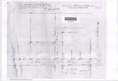
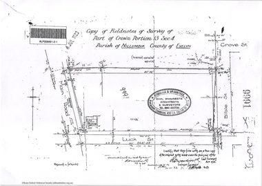
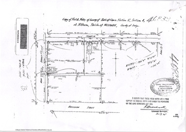
Document - Photocopy, Survey Fleld Notes of Part of Crown Portion 13, Section 4 at Eltham, Parish of Nillumbik, County of Evelyn, 1902-1903
... Survey Plan... street Survey Plan Vine street Application 33777 Map A4 printouts ...Main Road, Henry Street to Diamond Street; Silver Street to Bible Street Application No. 0337771902, 1903, arthur street, bible street, bird street, diamond creek (creek), diamond street, eltham, eltham railway station, henry street, main road, silver street, survey plan, vine street, application 33777, map -
 Eltham District Historical Society Inc
Document - Photocopy, Survey Fleld Notes of Part of Crown Portion 13, Section 4 at Eltham, Parish of Nillumbik, County of Evelyn, 18 May 1908
... Survey Plan... Survey Plan A4 printouts, 2 pages Survey Fleld Notes of Part ...Portion of land bounded by: Main Road, Luck Street, Bible Street, Arthur Street Application 37314 W. P. Steane, M.C.E. Civil Engineer and Surveyor, 18 May 1908application 37314, arthur street, bible street, eltham, luck street, main road, map, survey plan -
 Eltham District Historical Society Inc
Document - Photocopy, Survey Fleld Notes of Part of Crown Portion 13, Section 4 at Eltham, Parish of Nillumbik, County of Evelyn, 31 May 1907
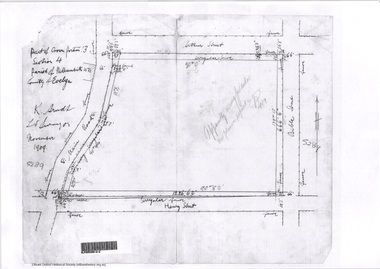
... Survey Plan... Street Main Road Map Survey Plan A4 printouts, 2 pages Survey ...Portion of land east of Main Road and north of Luck Street bounded by Bible Street Application 36708 K. Arndt, Licensed Surveyor, 31 May 1907application 36708, bible street, eltham, luck street, main road, map, survey plan -
 Eltham District Historical Society Inc
Document - Photocopy, Survey Fleld Notes of Part of Crown Portion 13, Section 4 at Eltham, Parish of Nillumbik, County of Evelyn, November 1909
... Survey Plan... Eltham henry street Main Road Map Survey Plan A4 printout Survey ...Portion of land bounded by Main Road, Arthur Street, Bible Street, Henry Street Application 36708 K. Arndt, Licensed Surveyor, November 1909application 5289, arthur street, bible street, eltham, henry street, main road, map, survey plan -
 Eltham District Historical Society Inc
Document - Photocopy, Survey Fleld Notes of Part of Crown Portion 12, Section 4 at Eltham, Parish of Nillumbik, County of Evelyn, 12 October 1910
... Survey Plan... Street Main Road Map Pitt Street Survey Plan A4 printouts, 2 ...Portion of land bounded by: Main Road, John Street, Bible Street, Pitt Street Application 38858 K. Arndt, Licensed Surveyor, 12 August 1910application 38858, bible street, eltham, john street, main road, map, pitt street, survey plan -
 Eltham District Historical Society Inc
Document - Photocopy, Survey Fleld Notes of Part of Crown Portion 12, Section 4 at Eltham, Parish of Nillumbik, County of Evelyn, 20 May 1911
... Survey Plan... Street Bridge Street Eltham Main Road Map Survey Plan York Street ...Portion of land bounded by: Main Road, York Street, Bible Street, Bridge Street Application 38629 Frederick Dudley Smith, M.C.E. Licensed Surveyor, 20 May 1911application 38629, bible street, bridge street, eltham, main road, map, survey plan, york street -
 Eltham District Historical Society Inc
Document - Photocopy, Survey Fleld Notes of Part of Crown Portion 13, Section 4 at Eltham, Parish of Nillumbik, County of Evelyn, 7 January 1924
... Survey Plan... Road Map Survey Plan A4 printouts, 2 pages Survey Fleld Notes ...Portion of land north of Luck Street bounded by: Main Road, Bible Street Application 9991 R. Woodstock, Land Surveyor, 7 January 1924application 9991, bible street, eltham, luck street, main road, map, survey plan -
 Eltham District Historical Society Inc
Document - Photocopy, Survey Fleld Notes of Part of Crown Portion 13, Section 4 at Eltham, Parish of Nillumbik, County of Evelyn, 7 May 1925
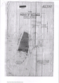
... Survey Plan... Station Luck Street Main Road Map Survey Plan A4 printouts, 2 ...Portion of land bounded by: Main Road, Eltham Railway Station Application 46785 J.T. Robinson, Surveyor, 7 May 1925application 46785, arthur street, bible street, eltham, eltham railway station, luck street, main road, map, survey plan -
 Eltham District Historical Society Inc
Document - Photocopy, Survey Fleld Notes of Part of Crown Portion 12, Section 4 at Eltham, Parish of Nillumbik, County of Evelyn, 30 September 1925
... Survey Plan... Brougham Street Eltham franklin street Main Road Map Survey Plan A4 ...Portion of land bounded by: Main Road, Franklin Street, Bible Street, Brougham Street Application 46839 R. Woodcock, Licensed Surveyor, 30 September 1925application 46839, bible street, brougham street, eltham, franklin street, main road, map, survey plan -
 Eltham District Historical Society Inc
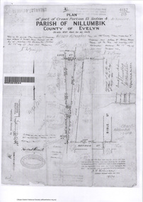
Survey Fleld Notes of Part of Crown Portion 13, Section 4 at Eltham, Parish of Nillumbik, County of Evelyn, 17 May 1926
... Survey Plan... Map Survey Plan A4 printout, 2 pages Survey Fleld Notes ...Portion of land bounded by: Eltham Railway Station, Main Road, Luck Street, Arthur Street Application 4182/215 J.T. Robinson, Licensed Surveyor, 17 May 1926application 4182/215, arthur street, eltham, eltham railway station, luck street, main road, map, survey plan