Showing 4516 items matching "surveying"
-
 Federation University Historical Collection
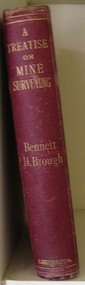
Book, Bennett H. Brough, A treatise on Mine-Surveying, 1904
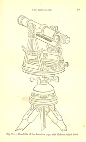
... A treatise on Mine-Surveying......surveying...Brough was an associate of theRoyal School of Mines, a member of the COuncil of the Institution of Mining Engineers, a fellow of the geological society and of the Institute of Chemistry, a member of the Mining Institute of Cornwall, and a former instructor of mine-surveying at the Royal School of Mines...Surface-surveys. plotting the survey, calculation of area, leveling, Telescope, Setting out, Mine-Surveying Problems, Mine Plans, Photographic Surveying, examination Surveying. ...Surface-surveys. plotting the survey, calculation of area, leveling, Telescope, Setting out, Mine-Surveying Problems, Mine Plans, Photographic Surveying, examination Surveying. ...The author, Bennett H. Brough was an associate of theRoyal School of Mines, a member of the COuncil of the Institution of Mining Engineers, a fellow of the geological society and of the Institute of Chemistry, a member of the Mining Institute of Cornwall, and a former instructor of mine-surveying at the Royal School of MinesRed had covered book 372 pages - part of Griffin's Mining Series. Contents include general explanatinos of surveying, an historical sketch, mineral deposits, mining terms, measures of length, measurement distances, the chain, rods, steel bands, measuring wheel, Miner's Dial, Magnetic needle, Fixed needle, German Dial, theodolite, traversing underground. Surface-surveys. plotting the survey, calculation of area, leveling, Telescope, Setting out, Mine-Surveying Problems, Mine Plans, Photographic Surveying, examination Surveying. Illustrations include: Whitelaw's Dial (Fig 22), Theodolite of the American Type with Hoffman tripod head, (fig 37a)mining, surveying, miner's dial, chain, survey, theodolite, scientific instruments -
 Victorian Aboriginal Corporation for Languages
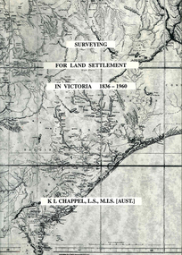
Book, K L Chappel, Surveying for land settlement in Victoria 1836-1960 : survey of the Vic-NSW boundary, survey of the Vic-SA boundary, 1996
... Surveying for land settlement in Victoria 1836-1960 : survey of the Vic-NSW boundary, survey of the Vic-SA boundary...surveying...A record of the early history of surveying for land settlement. Includes appendices on the border surveys between Victoria and South Australia and between Victoria and New South Wales....Surveying for land settlement in Victoria 1836-1960 : survey of the Vic-NSW boundary, survey of the Vic-SA boundary Book K L Chappel ...A record of the early history of surveying for land settlement. Includes appendices on the border surveys between Victoria and South Australia and between Victoria and New South Wales.maps, b&w photographs, illustrationssurveying, land settlement -
 Federation University Historical Collection
Photograph - Photograph - Black and White, Ballarat School of Mines Surveying Students
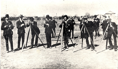
... Ballarat School of Mines Surveying Students...surveying...A group of Ballarat School of Mines surveying students 'in the field'. ...Barker Library (top floor) Mount Helen goldfields This group was possibly at White Flat, Ballarat. surveying ballarat school of mines class surveying students theodolite student activity A group of Ballarat School of Mines surveying students 'in the field'. ...This group was possibly at White Flat, Ballarat.A group of Ballarat School of Mines surveying students 'in the field'. surveying, ballarat school of mines, class, surveying students, theodolite, student activity -
 Federation University Historical Collection
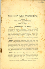
Book - Booklet, Mine Surveying and Mapping part 2
... Mine Surveying and Mapping part 2......surveying...It included a number of diagrams related to surveying and mapping....It included a number of diagrams related to surveying and mapping. Mine Surveying and Mapping part 2 Book Booklet ...This booklet was most probably used by Ballarat School of Mines students. 78 page stapled book with no cover. It included a number of diagrams related to surveying and mapping.ballarat school of mines, survey, surveying, mining, mapping -
 Parks Victoria - State Coal Mine - Wonthaggi
Book, Bennett H. BROUGH, Charles Griffin & Co. Ltd, "A treatise on mine surveying", C 1913
... "A treatise on mine surveying" ...Part of the George Hadden collection B.Descibes in detail all aspects of mine surveying..."A treatise on mine surveying" Hard Bound, red cover, gold lettering, 372 pages plus a 60 page advertising supplement...."A treatise on mine surveying" Book Bennett H. BROUGH, Charles Griffin & Co. ...A. Part of the George Hadden collection B.Descibes in detail all aspects of mine surveying"A treatise on mine surveying" Hard Bound, red cover, gold lettering, 372 pages plus a 60 page advertising supplement.Inside front cover: "A.Blackburn Shottou Colliery Co. Durham.", "G.Hadden" -
 Federation University Historical Collection
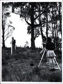
Photograph - Black and white photograph, Surveying Exercise
... Surveying Exercise...surveying...Two men, and a woman wearing a mini skirt undertake a surveying exercise in a bush location. It is thought to be land near the Mount Helen Campus....Barker Library (top floor) Mount Helen goldfields surveying mount helen mini skirt platform shoes desert boots scientific instruments student activities Two men, and a woman wearing a mini skirt undertake a surveying exercise in a bush location. ...Two men, and a woman wearing a mini skirt undertake a surveying exercise in a bush location. It is thought to be land near the Mount Helen Campus.surveying, mount helen, mini skirt, platform shoes, desert boots, scientific instruments, student activities -
 University of Melbourne, Burnley Campus Archives
Slide - Colour slides, Marcus Oldham College (c), Farm Surveying Land Management, Unknown
... Farm Surveying Land Management......surveying...1. 39 colour slides produced by Marcus Oldham College 2. 8 colour slides including dates Feb 1981, Mar 1983, Dec 1989. Photographs of surveying equipment and how it is used. Not scanned...Photographs of surveying equipment and how it is used. Not scanned Farm Surveying Land Management Slide Colour slides Marcus Oldham College (c) Ektachrome Kodachrome ...marcus oldham college, surveying, farming, surveying equipment, land management -
 University of Melbourne, Burnley Campus Archives
Photograph - Black and white print, Information Branch Victorian Department of Agriculture, Surveying Detail, Unknown
... Surveying Detail......surveying...Staff member demonstrating surveying equipment to 2 students in the Ornamental Garden....Staff member demonstrating surveying equipment to 2 students in the Ornamental Garden. ...Black and white photograph. Staff member demonstrating surveying equipment to 2 students in the Ornamental Garden.On reverse, "Photography Information Branch Victorian Dept of Agriculture Ref. No. 1981 (914-17)." "Return to James Pleasance." "Victorian College of Agriculture & Horticulture-Burnley gardens Swan Street, Richmond, Vic 3121."staff, demonstration, equipment, students, james pleasance, victorian college of agriculture & horticulture, burnley gardens, swan street, richmond, surveying, student outside classroom -
 Victorian Aboriginal Corporation for Languages
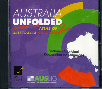
CD-ROM, Australian Surveying and Land Information Group, Australia unfolded : interactive atlas of Australia, 1996
... ...surveying...Australian Surveying and Land Information Group...Australia unfolded : interactive atlas of Australia CD-ROM Australian Surveying and Land Information Group ...Systems requirements: Macintosh version: Mac Plus (68030 or higher recommended), 5 MB hard disk space, 2 MB RAM (4 MB RAM recommended), CD-ROM drive, mouse, System 7 or above. "9314231106006"--CD-ROM. System requirements: Windows version: IBM compatible 386 or higher, 5MB hard disk space, 4MB RAM (8MB RAM recommended), VGA monitor, CD-ROM drive, mouse, Windows 3.1 or above. In box (19 x 27 x 5 cm.).CD-ROMtopographic maps, australian maps, surveying -
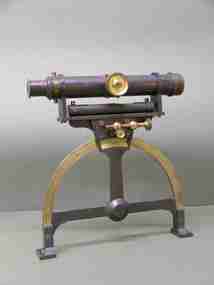
 Federation University Historical Collection
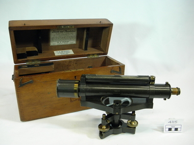
Instrument, W. H. Stanley, Surveying level, July 1899
... Surveying level......surveying...Used by students attending surveying classes at the School of Mines & Industries, Ballarat....Barker Library (top floor) Mount Helen goldfields Used by students attending surveying classes at the School of Mines & Industries, Ballarat. level theodolite surveying instrument surveying scientific instruments *The timber lid of the carry case has 'L3' painted on it in white paint. ...Used by students attending surveying classes at the School of Mines & Industries, Ballarat.Surveyor's level caste in metal with brass trimmings. Features external focus, twin inclined vertical crosshairs with stadia wires. With ray-shade clinomenter. Three levelling screws. Without transverse level (mounting provided). dust shield for object. Features glass lens x 2. Timber carry case features dovetailed joints, separate lid attached to body of case with two brass piano hinges along back side. Case has a metal carry handle screwed to each end. Matches tripod Item 4116 Item's serial number: 99142*The timber lid of the carry case has 'L3' painted on it in white paint. *The paper label glued to reverse side lid of inside carry box reads: STANLEY'S PATENT LEVELS AND THEODOLITES No.99142 July 1899 STADIA POINTS SET=1 : 100. In taking readings of a distant staff by means of the subtense points in the diaphragm, read every 1/100 foot (or metre) on the staff as being equal to one foot (or metre) of distance from the centre of the instrument adding to the reading of plus constant of 18 3/4 inchess from any distance shown. W.F. Stanley, Great Turnstile, Holborn, London. *The paper label glued to lower edge inside lid of carry box reads: N. H. SEWARD, "Optical House" 457 BOURKE STREET (Near Queen Street) MELBOURNE *Engraving on brass plate encompassing the catch on front edge of the timber carry case reads: H&C L (inside an engraved heart on LSH) EUCHRE LEVER (engraved on RHS of brass plate) *Maker's mark is engraved along the length of the telescope barrel: 99142 Stanley. Great Turnstile Holborn, London. level, theodolite, surveying instrument, surveying, scientific instruments -
 Bendigo Military Museum
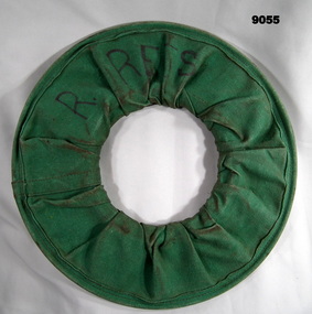
Equipment - Surveying Tape 100m Steel, Circa 1960s
... Surveying Tape 100m Steel...These steel Surveying measuring tapes were used by members of the Royal Australian Survey Corps (surveyors and chainmen) for simple short length measurements between points.....1 A 100m steel Surveying measuring tape rolled in a green canvass cover. ...Royal Australian Survey Corps RASvy Fortuna Army Survey Regiment Army Svy Regt Labelled "R.REES" .1 A 100m steel Surveying measuring tape rolled in a green canvass cover. ...These steel Surveying measuring tapes were used by members of the Royal Australian Survey Corps (surveyors and chainmen) for simple short length measurements between points..1 A 100m steel Surveying measuring tape rolled in a green canvass cover. The tape is 3mm in width. The first 3m replaces a broken section with yellow and red tape. .2 Green Canvas cover to hold the rolled-up steel tape.Labelled "R.REES"royal australian survey corps, rasvy, fortuna, army survey regiment, army svy regt -
 Federation University Historical Collection
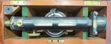
Instrument - Scientific Instrument, W.M. Drummond & Co, Surveying Level
... Surveying Level......surveying...A surveying level. Longitude and transverse bubbles, magnet, compass. ...Fits tripod cat. no. 04132 Surveying Level Instrument Scientific Instrument W.M. ...Used for survery at the Ballarat School of Mines for Civil and Mining classes.A surveying level. Longitude and transverse bubbles, magnet, compass. External focussing. Twin vertical inclined hair lines. Four levelling screws. Objectove lens with dust shield. Fits tripod cat. no. 04132thodolite, surveying, ballarat school of mines, w.m. drummond, civil engineering, mining engineering, scientific instruments -
 Federation University Historical Collection
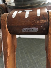
Instrument - Scientific Instruments, W.& L.E. Gurley, Collapsible Leg Surveying Instrument: Tripod
... Collapsible Leg Surveying Instrument: Tripod......surveying...Used with the Plane Table - Item 4130, in surveying classes at Ballarat School of Mines. ...Collapsible Leg Surveying Instrument: Tripod Instrument Scientific Instruments W.& L.E. ...Used with the Plane Table - Item 4130, in surveying classes at Ballarat School of Mines. Item 4127, Tripod Location Chains, may also have been used.A large tripod of timber construction. Concave top mount flange to receive matching spherical spigot. Spacer block halfway up each twin-strut leg.In white paint on the top "PTI" Manufacturer's stamp on each leg - circular. "W.& L.E. GURLEYtripod, surveying, scientific instrument, ballarat school of mines, plane table, location chains, w & l e gurley -
 Bendigo Military Museum
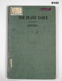
Manual - The Plane Table - Its Use in Surveying, McGraw Publishing Company, New York, USA, 1908
... The Plane Table - Its Use in Surveying...This manual details how to use the "Plane Table" for Surveying purposes...."scm - B0 - 86-72" written underneath. stamps- Australian Intelligence Corps, Headquarters library No 150 (difficult to read) on first page and stamped "CANCELLED" , Stamp School of Military Survey Library Call No 526 - 9825 LOV. Another stamp on title page - Department of Defence Library 46.10 and 12411. ...The Plane Table - Its Use in Surveying Manual The Plane Table - Its Use in Surveying McGraw Publishing Company, New York, USA ...The plane table instrument was a simple but very effective early method of producing maps. Some very early editions were produced by the Australian Survey Corps after its formation in 1915 using this method. This manual details how to use the "Plane Table" for Surveying purposes.Hard Cloth covered Covers front and back, paper pages. title page has rubber stamp impressions (see below). Contents page, symbols page, pages 1-47 and index page.Adhesive label on front "46.10 and 12411", "1504" in purple also on front cover, Numbers inside front cover - "Acc. No. 000076" and crossed out. "scm - B0 - 86-72" written underneath. stamps- Australian Intelligence Corps, Headquarters library No 150 (difficult to read) on first page and stamped "CANCELLED" , Stamp School of Military Survey Library Call No 526 - 9825 LOV. Another stamp on title page - Department of Defence Library 46.10 and 12411. Second stamp 2/D. M.O.S. 2012 with CANCELLED. royal australian survey corps, rasvy, army survey regiment, army svy regt, asr, fortuna -
Clunes Museum
Book, THOMAS BAKER et al, SUBTERRANEOUS SURVEYING BY THOMAS FENWICK AND THOMAS BAKER, 1871
... SUBTERRANEOUS SURVEYING BY THOMAS FENWICK AND THOMAS BAKER...SURVEYING...Clunes Museum 36 Fraser Street enter building through Collins Place Clunes goldfields SURVEYING TECHNICAL SUBTERRANEOUS SURVEYING WITH AND WITHOUT THE MAGNETIC NEEDLE IN THE FIELD. ...SUBTERRANEOUS SURVEYING WITH AND WITHOUT THE MAGNETIC NEEDLE IN THE FIELD.SMALL BOOK, HARD GREEN COVER, GOLD WRITING, 226 PAGES. CONTENTS INDEX IN FRONT. TRAVERSE TABLES, CONTAINS A CATALOGUE OF BOOKS AT BACK.non-fictionSUBTERRANEOUS SURVEYING WITH AND WITHOUT THE MAGNETIC NEEDLE IN THE FIELD. surveying, technical -
 Otway Districts Historical Society
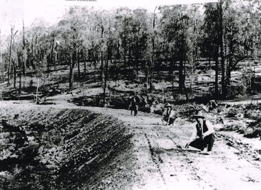
Photograph, Knox Collection, Surveying construction near Barongarook, 1900, 1900
... Surveying construction near Barongarook, 1900....B/W. Three men surveying the construction of a curved bed on which track will be laid, near Barongarook, Victoria....Surveying construction near Barongarook, 1900. ...In 1898 a recommendation for a railway of 2 ft 6 in gauge was handed down by the Parliamentary Standing Committee on Railways, to cost $138,000. Construction of the Colac-Beech Forest railway line began in 1900. About 100 men were employed in laying and ballasting the track while others formed the earthworks and the building of culverts and bridges. The earthworks of gravel ballast 150 mm deep were formed by horse and scoop or by shovel. Once the bed had been laid surveyors went along to check the layout, particularly all check rail curves and all 100 metre curves which the surveyors in the picture are doing.B/W. Three men surveying the construction of a curved bed on which track will be laid, near Barongarook, Victoria.colac; beech forest; barongarook; railways; -
Federation University Historical Collection
Formulae Mine Surveying
... Formulae Mine Surveying......survey...Formulae for the various calculations involved in Mining Surveying - areas, volumes, weights, chain strength, loads, Columns, angles, side lengths...Barker Library (top floor) Mount Helen goldfields mine surveying survey Formulae for the various calculations involved in Mining Surveying - areas, volumes, weights, chain strength, loads, Columns, angles, side lengths Formulae Mine Surveying ...Formulae for the various calculations involved in Mining Surveying - areas, volumes, weights, chain strength, loads, Columns, angles, side lengthsmine surveying, survey -
Federation University Historical Collection
Book, W.M. Gillespie, A Treatise on Levelling, Topography and Higher Surveying, 1884
... A Treatise on Levelling, Topography and Higher Surveying. ...Surveying...A Treatise on Levelling, Topography and Higher Surveying. Book W.M. Gillespie D. Appleton & Co. ...Black/blue cloth hard cover of 173 pages. surveying, topography, levelling, w.m. gillespie -
Creswick Campus Historical Collection - University of Melbourne
Equipment, Surveying Aneroid
... Surveying Aneroid...Surveying Aneroid compensated...Creswick Campus Historical Collection - University of Melbourne 4 Water Street University of Melbourne Creswick Campus Building 719/718 Creswick goldfields Surveying Aneroid compensated Equipment Surveying Aneroid Equipment ...Surveying Aneroid compensatedEquipment -
 Federation University Historical Collection
Book, A Rudimentary Treatise on Land Engineering Surveying, 1902
... A Rudimentary Treatise on Land Engineering Surveying...surveying...Barker Library (top floor) Mount Helen goldfields surveying baker dixon f.e. dixon t. baker engineering Brown hard covered book A Rudimentary Treatise on Land Engineering Surveying Book Book T. ...Brown hard covered booksurveying, baker, dixon, f.e. dixon, t. baker, engineering -
Tatura Irrigation & Wartime Camps Museum
Book, Surveying, 1898
... Surveying...surveying...Tatura Irrigation & Wartime Camps Museum 49 Hogan Street Tatura the-murray Used by surveyors, schools and colleges as a text book surveying baker t dixon fe craven w tatura terrestrial Light brown linen like covered cardboard technical book used in schools and colleges. 17th Ediction, revised and extended, numerous illustrations Surveying Book ...Used by surveyors, schools and colleges as a text bookLight brown linen like covered cardboard technical book used in schools and colleges. 17th Ediction, revised and extended, numerous illustrationssurveying, baker t, dixon fe, craven w, tatura, terrestrial -
Tatura Irrigation & Wartime Camps Museum
Book, Agricultural Surveying, 1901
... Agricultural Surveying......surveying...Tatura Irrigation & Wartime Camps Museum 49 Hogan Street Tatura the-murray Used by surveyors agricultural surveying scott proff j tatura surveying irrigation terrestrial Light brown cloth covered cardboard cover. "245" and "1/6" on the spine Agricultural Surveying Book ...Used by surveyorsLight brown cloth covered cardboard cover. "245" and "1/6" on the spineagricultural surveying, scott, proff j, tatura, surveying, irrigation, terrestrial -
 Bendigo Military Museum
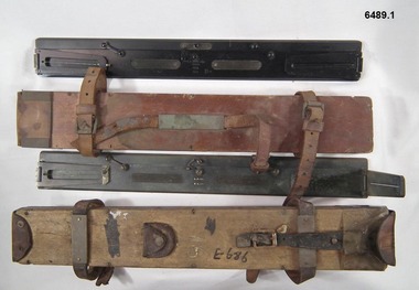
Instrument - Plane Table Surveying - Simple Alidade, ER Watts and Son, London, 1938
... Plane Table Surveying - Simple Alidade...Plane table Surveying is a relatively portable and inexpensive method and was used extensively before the advent of sophisticated surveying instruments. ...Plane table Surveying is a relatively portable and inexpensive method and was used extensively before the advent of sophisticated surveying instruments. ...The Plane Table Alidade was used as the sighting Instrument in the production of historical manual hand drawn maps. A Plane Table Board mounted on a tripod is levelled and the Alidade is placed on the table with the vanes perpendicular to the it. Each sighting vane has a central thread lined up on the target and the angle to that target point is then drawn on the map sheet using the beveled fiducial edge. Plane Table Surveying is used as a quick method where less accuracy is required or needed. Plane table Surveying is a relatively portable and inexpensive method and was used extensively before the advent of sophisticated surveying instruments. The photo at 6489.2 is an Australian Army Survey Corps Party using a Plane Table Alidade in Syria during WWII. See also item 6580 which is the Plane Table with tripod legs that was used with the Alidade.Two Plane Table sighting instruments (Alidade) used for historical manual map making housed in wooden transit boxes. A brass instrument with folding sights at each end and a beveled fiducial edge in one edge. The front sight is the object vane and the rear sight is the sight vane. There is a sliding arm attached to the base to draw parallel lines to the fiducial edge. Very slight differences in model between these two instruments.First Instrument, "ER Watts and Son, London, 1938, MkII, Box Label 423. Second Instrument - R. E-Co, Mk.II, stamped E686, Box Label 686.royal australian survey corps, rasvy, fortuna, army survey regiment, army svy regt, asr -
Tatura Irrigation & Wartime Camps Museum
Book, Practical Surveying, 1901
... Practical Surveying......surveying...Gold writing on spine Practical Surveying Book ...Used by surveyors and as an educational text bookDark green linen like covered cardboard technical book. Gold writing on spinepractical surveying, usill gw, craven w, tatura, surveying, terrestrial, books, technical -
 Stawell Historical Society Inc
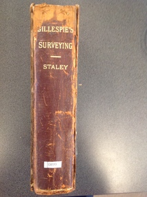
Book, Gillespie & Staley, Gillespie's Surveying. A Treatise on Surveying 1888, 1888
... Gillespie's Surveying. A Treatise on Surveying 1888...Stawell Historical Society Inc 46 Longfield St Stawell grampians stawell education Robert Robson Stawell Grammar School 22nd Feb 1888 Gillespie's Surveying. A Treatise on Surveying 1888 Book Gillespie & Staley ...Robert Robson Stawell Grammar School 22nd Feb 1888stawell education -
 Rutherglen Historical Society
Image, Survey Tree, Jacks Road
... Survey Tree, Jacks Road...Original blazed survey tree was removed and then replaced by Gas Workers...Colour photograph of the remains of a survey tree, concreted into the ground. This photo is a close-up to better show the survey marks....Survey marks on tree blaze...This photo is a close-up to better show the survey marks. Survey Tree, Jacks Road Image ...Original blazed survey tree was removed and then replaced by Gas WorkersColour photograph of the remains of a survey tree, concreted into the ground. This photo is a close-up to better show the survey marks.Survey marks on tree blazetree, survey reference marks, blazed tree, jacks road -
Clunes Museum
Equipment - SURVEY MARKER
... ...SURVEYING...ON HEAD OF MARKER: SURVEY MARK 1. PENALTY L50 FOR INTERFERENCE. ...WORDING ON CARDBOARD "ORIGINAL SURVEY MARKER MOUNT CAMERON"...SURVEY MARKER MOUNT CAMERON SURVEYING WORDING ON CARDBOARD "ORIGINAL SURVEY MARKER MOUNT CAMERON" ORIGINAL SURVEY MARKER. ...ORIGINAL SURVEY MARKER. MOUNT CAMERON. ROUND MARKER WITH A STEM WHICH IS BROKEN. ON HEAD OF MARKER: SURVEY MARK 1. PENALTY L50 FOR INTERFERENCE. MOUNTED ONTO CARDBOARDWORDING ON CARDBOARD "ORIGINAL SURVEY MARKER MOUNT CAMERON"survey marker, mount cameron, surveying -
 Bendigo Military Museum
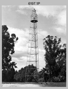
Photograph - Royal Australian Survey Corps Survey Observation Towers, c1950s
... Royal Australian Survey Corps Survey Observation Towers......surveying...This is a set of seven photographs of Royal Australian Survey Corps surveyors setting up observation towers in the field and undertaking survey observations during mapping and geodetic control operations. c1950s. ...This is a set of seven photographs of Royal Australian Survey Corps surveyors setting up observation towers in the field and undertaking survey observations during mapping and geodetic control operations. c1950s. ....1P with paper tag annotated ‘Bilby Tower’ .4P on back – ‘Bilby Tower’. .5P on back – ‘Survey Observing Tower. Observing tower used for angular measurement in flat country. 75’ high – CAPT Ricketts climbing. .6P, .7P on back. ‘1960s?’...Army Survey Regiment...Royal Australian Survey Corps Survey Observation Towers Photograph Royal Australian Survey Corps Survey Observation Towers Army Survey Regiment ...This is a set of seven photographs of Royal Australian Survey Corps surveyors setting up observation towers in the field and undertaking survey observations during mapping and geodetic control operations. c1950s. Survey observation towers were used mainly to take angular measurements in flat or heavily forested terrain, where height was necessary to achieve observer’s line-of-sight between field survey station. The Bilby Tower seen in photo .5P was erected to a height of 75 feet (23m) above ground level. The use of the Bilby Tower in Topographic Squadron’s field survey operations from 1955 to 1966 is described in page 54 of Valerie Lovejoy’s book 'Mapmakers of Fortuna – A history of the Army Survey Regiment’ ISBN: 0-646-42120-4. CAPT George Ricketts’ period of service was from 1942 to 1976 reaching the rank of LTCOL. It is noted in page 35 of Valerie Lovejoy’s book that then SGT Ricketts hand lettering skills came to the fore from his contribution to the draughting of one of the Japan’s Instruments of Surrender in 1945.This is a set of seven photographs of Royal Australian Survey Corps surveyors setting up observation towers in the field and undertaking survey observations during mapping and geodetic control operations. c1950s. The photographs were printed on photographic paper and are part of the Army Survey Regiment’s Collection. The photographs were scanned at 300 dpi. .1) - Photo, black & white, c1950s, ‘Bilby’ survey observation tower. .2) - Photo, black & white, c1950s, CAPT George Ricketts climbing ‘Bilby’ survey observation tower. .3) - Photo, black & white, c1950s, geodetic survey equipment on ‘Bilby’ survey observation tower. .4) - Photo, black & white, c1950s, two unidentified field surveyors on ‘Bilby’ survey observation tower. .5) - Photo, black & white, c1950s, two unidentified field surveyors, with CAPT Ricketts climbing ‘Bilby’ survey observation tower. .6) - Photo, black & white, c1950s, two unidentified field surveyors undertaking observations on survey observation tower. .7) - Photo, black & white, c1950, two unidentified field surveyors erecting or dismantling a survey observation tower..1P with paper tag annotated ‘Bilby Tower’ .4P on back – ‘Bilby Tower’. .5P on back – ‘Survey Observing Tower. Observing tower used for angular measurement in flat country. 75’ high – CAPT Ricketts climbing. .6P, .7P on back. ‘1960s?’royal australian survey corps, rasvy, army survey regiment, army svy regt, fortuna, asr, surveying -
 Federation University Historical Collection
Instrument - Scientific Equipment, Miner's Dial, c1893 - 1901
... ...surveying...Used for surveying classes at the Ballarat School of Mines. ...A surveying instrument consisting of theodolite with single crosshair(.1) mountable on a magnetic compass (.2), designed to sit inside a polished wood carry box. ...On suppliers label: "Instrument maker to the surveying and engineering departments of her Majesty's Government of South Australia"...Used for surveying classes at the Ballarat School of Mines. ...Used for surveying classes at the Ballarat School of Mines. Purchased/acquired during Queen Victoria's reign. The 1893 Ballarat School of Mines Calendar states that mine surveying instruments "always at the disposal of the students" including "one miner's dial".A surveying instrument consisting of theodolite with single crosshair(.1) mountable on a magnetic compass (.2), designed to sit inside a polished wood carry box. Serial Number 4470On suppliers label: "Instrument maker to the surveying and engineering departments of her Majesty's Government of South Australia"ballarat school of mines, surveying, scientific instruments, scientific objects, otto boettger, optician, miner's dial -
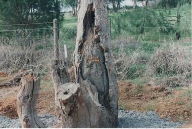
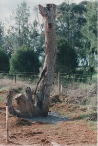 Rutherglen Historical Society
Image, Survey Tree, Jacks Road
... Survey Tree, Jacks Road...Original blazed survey tree was removed and then replaced by Gas Workers...Colour photograph of the remains of a survey tree, concreted into the ground...Survey marks on tree blaze...Rutherglen Historical Society Murray Street Rutherglen high-country Original blazed survey tree was removed and then replaced by Gas Workers tree survey reference marks blazed tree jacks road Survey marks on tree blaze Colour photograph of the remains of a survey tree, concreted into the ground Survey Tree, Jacks Road Image ...Original blazed survey tree was removed and then replaced by Gas WorkersColour photograph of the remains of a survey tree, concreted into the groundSurvey marks on tree blazetree, survey reference marks, blazed tree, jacks road