Showing 19 items matching "swamp creek road"
-
 Lakes Entrance Historical Society
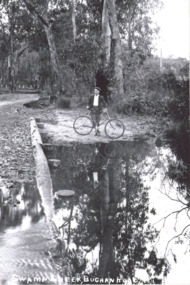
Photograph - Swamp Creek Buchan Road
... Swamp Creek Buchan Road...Swamp Creek Buchan Road...Boy on a bike standing by a waterhole Photograph Swamp Creek Buchan Road ...Black and white copy of a sepiaPostcard. Boy on a bike standing by a waterholeSwamp Creek Buchan Road -
 Marysville & District Historical Society
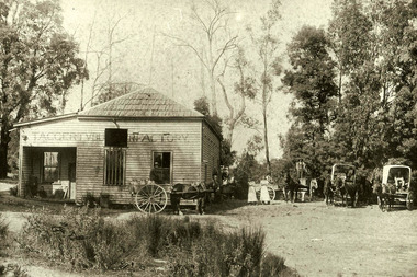
Photograph (Item) - Black and white photograph, 1904
... ...swamp creek road...The building no longer exists but materials from the original Taggerty Butter factory building now form part of the Williamson house off Swamp Creek Road. taggerty victoria taggerty butter factory little river kennedy family j b coombs acheron station thornton upper thornton alexandra dairy company williamson swamp creek road A black and white photograph of the Taggerty Butter Factory in Victoria. ...A black and white photograph of the Taggerty Butter Factory in Victoria.A black and white photograph of the Taggerty Butter Factory in Victoria taken around 1904. The Taggerty Butter factory opened in 1892 in the township on the Little River. It was run by the Kennedy family and built by J.B. Coombs of Acheron Station. Coombs was later Shire President. Milk had been previously taken daily to the steam-driven separators at Thornton. Upper Thornton. The cream was separated and the remains were taken back to the farms for the pigs and calves. Before these town separators existed butter had been made at home in a barrel, salted, and stored. The operation at Taggerty ceased in 1908 and the Alexandra Dairy Company took over production. The building no longer exists but materials from the original Taggerty Butter factory building now form part of the Williamson house off Swamp Creek Road.taggerty, victoria, taggerty butter factory, little river, kennedy family, j b coombs, acheron station, thornton, upper thornton, alexandra dairy company, williamson, swamp creek road -
 Warrnambool and District Historical Society Inc.
Map - Fire Maps, Region 5 Fire Control Map, 1963
... Places covered include Cavendish, Hamilton, Glen Thompson, Dunkeld, Hawkesdale, Warrnambool, Port Fairy and Peterborough and the maps show the type of roads, the swamps and creeks, rivers, railways, mountains and towns....Places covered include Cavendish, Hamilton, Glen Thompson, Dunkeld, Hawkesdale, Warrnambool, Port Fairy and Peterborough and the maps show the type of roads, the swamps and creeks, rivers, railways, mountains and towns. ...Two fire maps of south west Victoria.1 This is a rectangular piece of linen folded several times to form a packet with the front part covered with a brown card. The cover has a blue and white label. The map has a white base with red and green markings and red and black printing .2 As .1 abovenon-fictionTwo fire maps of south west Victoriafire maps, warrnambool history -
 Eltham District Historical Society Inc
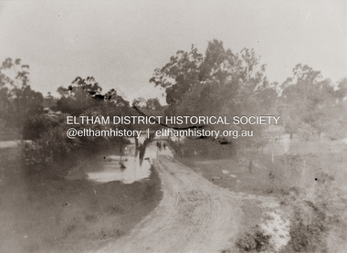
Photograph, Diamond Creek in flood over Glen Park Bridge, Eltham, c. 26 August 1924
... Significant flooding of the Diamond Creek occurred in Eltham and Glen Park on Tuesday, August 26, 1924 with several houses swamped and all bridges covered except the Greensborough Road Bridge. ...Eltham District Historical Society Inc 728 Main Rd Eltham melbourne Significant flooding of the Diamond Creek occurred in Eltham and Glen Park on Tuesday, August 26, 1924 with several houses swamped and all bridges covered except the Greensborough Road Bridge. ...Significant flooding of the Diamond Creek occurred in Eltham and Glen Park on Tuesday, August 26, 1924 with several houses swamped and all bridges covered except the Greensborough Road Bridge. [Houses at Eltham Flooded. (1924, August 27). The Argus (Melbourne, Vic. : 1848 - 1957), p. 19. Retrieved from http://nla.gov.au/nla.news-article4156891] The Glen Park Bridge was originally built as a replacement for an older private bridge built by a man named Foley around 1880. In 1911 Heidelberg and Eltham agreed to share the costs to build a new bridge. Construction began in June 1915 and it was officially opened by Cr. Taylor on Cup Day, November 1915. The bridge was destroyed by floodwaters in the afternoon of 20 September 1959 during construction of the new Wattletree Road bridge. The new bridge west embankment joined the existing road at approximately where the bend in the road is situated in the photograph.Colour photograph of originalfloods, eltham, diamond creek (creek), egan's crossing, eltham-diamond creek road, glen park bridge, glen park road -
 Glen Eira Historical Society
Document - BOX FAMILY
... Road... Harwood Thomas... Box Violet... Hordeen Lebbens... Augustus Arthur... Wattle... Pioneers... Ancient Order of Foresters... Council of Moorabin... Elster Creek... Primitive Methodist Church... Lewis’ Timber Yard... Grape Growing... Paling House... Wells... Water Wagon... Market Gardens... Farming... Aboriginal People... King Billy... Chinese... Kayon (?)... Kay You (Yu?)... Cheong Ki... Boxer Rebellion... Chinese Missionary... Brickmakers... Midwife... Corben’s Monumental Masons... Sculptor... Cottage... Parlour... Verandah... Scullery... Le Man’s Swamp...Robilliard George James Box Ester Box Fanny (Downard) Box Eleanor Philbrick Richard Fairlam Richard Hale Jasper Dendy Henry Renick Mark Renick Stefanie (nee Riemann) Brighton Cemetery Ormond East Brighton Prahran Centre Road Jasper Road Manchester Road McKinnon Road North Road Brighton Box Cottage Moorabbin Historical Society Thomas Street Elsternwick Paterson Road East Bentleigh Tucker Road Jasper Road Harwood Thomas Box Violet Hordeen Lebbens Augustus Arthur Wattle Pioneers Ancient Order of Foresters Council of Moorabin Elster Creek Primitive Methodist Church Lewis’ Timber Yard Grape Growing Paling House Wells Water Wagon Market Gardens Farming Aboriginal People King Billy Chinese Kayon (?) Kay You (Yu?) Cheong Ki Boxer Rebellion Chinese Missionary Brickmakers Midwife Corben’s Monumental Masons Sculptor Cottage Parlour Verandah Scullery Le Man’s Swamp ...Extensively detailed family history from 1838 in UK to present day. Provides much local history and social history into early pioneering and market gardening families. Forty one page computer print out with numerous black and white photographs.box w.h. george, box george, box mary nee cripps, box caroline, box william, box henry, box john, box anna, box eliza, box elizabeth nee avis, box francis, box lydia, moeller a., mclean n., robilliard george james, box ester, box fanny (downard), box eleanor, philbrick richard, fairlam richard, hale jasper, dendy henry, renick mark, renick stefanie (nee riemann), brighton cemetery, ormond, east brighton, prahran, centre road, jasper road, manchester road, mckinnon road, north road, brighton, box cottage, moorabbin historical society, thomas street, elsternwick, paterson road, east bentleigh, tucker road, jasper road, harwood thomas, box violet, hordeen lebbens, augustus arthur, wattle, pioneers, ancient order of foresters, council of moorabin, elster creek, primitive methodist church, lewis’ timber yard, grape growing, paling house, wells, water wagon, market gardens, farming, aboriginal people, king billy, chinese, kayon (?), kay you (yu?), cheong ki, boxer rebellion, chinese missionary, brickmakers, midwife, corben’s monumental masons, sculptor, cottage, parlour, verandah, scullery, le man’s swamp, flower nursery, chook houses, ladies college, moorabbin roads board, western market, eastern market, victoria market, st. kilda road, nepean road/highway, mckinnon, ormond, carnegie, oakleigh, murrumbeena, moorabbin, mordialloc, heathcote, bentleigh, brighton east, manchester road, brighton council, city of moorabbin, west joseph, porter harriet, moore henry, moeller a (moller), box mary, lindsay mccurry elizabeth, lindsay elizabeth, lindsay henry, lindsay frederick, schmidt william, robilliard james cpt., beckett ida, beckett nellie, beckett martha, beckett martha maud, robinson eleanor, robinson joyce, dowling thomas, anderson william snowden, mccurry henry mr & mrs, box emily jane (nee mccurry), jorgensen justin, jorgensen dr., jorgenson bertha, ross william murray, st. kilda, merrie creek, pentridge (now coburg), murray road, wyuna dunoos st, grange road, rosstown, tucker rd, elizabeth st, common school no 213 east brighton, bentleigh, steel roads tracks, rabbits, cheltenham, brighton cemetery, cheltenham cemetery, paterson road, east boundary road, baptist church, lay preachers, missionaries- china, oakleigh tyre works, belfast hotel sandhurst (bendigo), mornington, gas street lighting, brighton historical society, moorabbin primary school, bravis road, lewis street, chalmers street, grange road, butcher shops, ormond state school, oakleigh council, wedding dress, methodist children’s home cheltenham, bentleigh baptist church, auctioneer, lindsay mark, balkham jane, balkham stephen, reitman august william, fitzwilliam catherine, quashdorf (?phonetic) mr, box violet, montford paul, reitman stephanie (renick mrs), reitman william, box ada, downard alicia (lill), downard arthur, downard edward, graham elizabeth, downard octavia rose, downard william alfred, downard arthur henry (harvey), downard fanny, thompson eliza jane, box lena caroline, viloudaki rebecca, box anna (pay), pay henry, box eliza (gurr), johnson geoffrey, rushall eleanor (nellie), gurr eliza nee box, gurr jabez henry tasman, marriot william mrs, ross william murray, box gladys (nee battersby), box dulcie (bussell), bussell samuel robert, bussell norma (hoult), bussell darren lyle, bussell craig andrew, bussell sylvia june (barry), barry j. haydon, barry rachael alexandra, barry phillipa anne, barry vanessa kate, bussell joan lorraine (millie), millie john, bussell harold leslie, euston mr, purdue edgar robert, box lydia elizabeth, wilkinson coral doreen, mitchell donald, centre road, court pride of st george aof, dunoon street, vickery street, darey street/ave., oakleigh state school, methodist church, mill street, koornang road, regent street, marriage road, box olivia christina, box ernest charles, box walter william, lawson robert, lawson nancy eunice (curtis), box walter stanley, box eleanor (nellie) rushall, box martha, box john, box nellie gladys, andrews william (bill), box ray, mccurry mrs elizabeth, box william henry george, schreiber family, jorgensen family, downward arthur, downward alicia – lill, downward octavia rose, downward william alfred, downward arthur henry/harvey, cummings ida, cummings william, downward alice (nee cleary), downward ada, downward lucy (mrs bailey), downward alice, downward arthur harvey, bailey lawrence, bailey ian, bailey carol viola (bartlett), bailey colin harvey, bailey julie alison (hardware), bailey val, bailey adina, bailey david, bartlett brian, bartlett bradley grant, bartlett clayton lawrence, hardware michael, hardware dion michael colin, hardware jevon michael bailey, box elanor, box alice amelia (dale), dale george, dale elizabeth, dale lilly, dale john, dale thomas, dale rose, dale ethelbert, dale george, dale elsie, box thomas henry, box annie lavinia (rogers), rogers annie elizabeth, rogers william richard, box arthur walter, nelson dagma marie (box), box walter kingston, box marie, box cecilia eliza (ainger), ainger james, box ida may, cumming william george, cumming wendy (nee mansell), cumming susan, cumming paul, cumming felicity (steel), cumming shane, cumming melissa, cumming angel, box harold, box dorothy may (jackson), jackson frederick, jackson margaret (walker), jackson judith, walker david, walker michelle (neville), neville andrew, walker darren, walker rebecca (coyne), walker joshua, walker bradley, johnson steven, johnson carl, johnson judith (jackson), johnson peter, johnson melissa (hamid), johnson craig, ely johnson/jackson judith, ely steven, linham arthur, box thelma elizabeth (eagle), eagle keith, eagle nancye elizabeth (harpin), harkin john, harkin mary anne (howe), howe barry, howe samuel, harkin michael, harkin christopher, harkin elizabeth, eagle roddan, eagle carolyn (mansell), eagle gerard, eagle kerri – lee, box avis ann (eldridge), eldridge alf, eldridge robert, eldridge sandra, eldridge adam, eldridge nicholas, eldridge patric, eldridge john, eldridge carol (biggs), eldridge robert james, eldridge catherine elizabeth, eldridge meredith, box william john, box maud (nee hanchette), box malcome, box sandra (ede), box stephen, box nicolle, box andrew, box christine (dormer), box corrina, box jennifer (turpin), turpin phillip, box herbert, box olwyn (richard), box elaine henry, henry bruce, henry james, henry robin, henry david, box richard, box nerida (bowen), box duncan, box john, box cerwiden, box ewan, box bryan, box collen (malony), box kieran, box eden, box christopher, box pam (smith), box sue (tirchett), box thomas, box william, box george frederick, box olive (cameron), box eliza jane (thompson), box francis george, box lena caroline, box-hembrow mable alma, box charles francis, clinch mr., box robinson jessie melinda, box clay edith florence, north brighton, waun alex, waun robert, marquis peter, sheppard w., warnbach mr, marriott william mrs, box dorothy (seabrook), box hazel, box jessie, box frank (francis), seabrook len, box henry, seabrook albert, seabrook stanley allan, barry j. haydon, barry rachel alexandra, millie john, bussell harold leslie, bussell sue, bussell leanne melinda, bussell benjamin leslie, bussell lynette, box george, box jean (holms), box george, box alisa (hughes), hughes justin, hughes ebony, hughes tasman, box robin, box veronica (roman), box andrea roman, box lisa roman, box jodi roman, box malcome, box sue (kerrison), box amanda, box anthony, clay john (jack) francis, clay lynda blanche (nee sibte), clay vivien, clay majory joy, lipman vernon (vern) ronald, clay kenneth graham, clay laura jean -
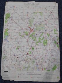 Bendigo Historical Society Inc.
Map - Bush Fire Control Map Bendigo District
... Cream coloured parchment map showing roads, railway lines, telephone lines, rivers, creeks and water courses. Also marked are houses, Post Offices, Police stations, bush fire brigades, water channels, swamps, marshes, dense, medium and scattered timber, aqueducts and reservoirs. ...Bush fires Bendigo area map Cream coloured parchment map showing roads, railway lines, telephone lines, rivers, creeks and water courses. Also marked are houses, Post Offices, Police stations, bush fire brigades, water channels, swamps, marshes, dense, medium and scattered timber, aqueducts and reservoirs. ...A Bush Fire Control map is a valuable tool used by emergency services and communities to respond to respond to bushfires.Cream coloured parchment map showing roads, railway lines, telephone lines, rivers, creeks and water courses. Also marked are houses, Post Offices, Police stations, bush fire brigades, water channels, swamps, marshes, dense, medium and scattered timber, aqueducts and reservoirs. Villages, districts and Towns are clearly marked. Printed in red, green, black and blue. Very clear and easy to read. Undated.bush fires, bendigo area map -
 Ringwood and District Historical Society
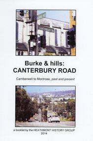
Book, Burke & Hills: Canterbury Road Camberwell to Montrose, by Heathmont History Group - 2014
... Grand homes and churches at one end, major and minor shopping centres along the 25km, factories now where farms were, big box stores, fast food outlets, train stations, resrvoir, traffic, residential stretches, modern apartment blocks, parklands, child-minding centres, sporting ovals, a sewage farm, hotels, quarries, commercial developments, plant nurseries, a golf course, bridges, memorials, Asian food shops, telecommunication towers, bushland, creeks, crossroads, traffic lights, mansions, orchards, swamps ... Delaneys Road, renamed Canterbury Road after a 19th century Victorian Governor, is a fascinating study in land use and history as suburban Melbourne has continually diversified and pushed outwards. ...Grand homes and churches at one end, major and minor shopping centres along the 25km, factories now where farms were, big box stores, fast food outlets, train stations, resrvoir, traffic, residential stretches, modern apartment blocks, parklands, child-minding centres, sporting ovals, a sewage farm, hotels, quarries, commercial developments, plant nurseries, a golf course, bridges, memorials, Asian food shops, telecommunication towers, bushland, creeks, crossroads, traffic lights, mansions, orchards, swamps ... Delaneys Road, renamed Canterbury Road after a 19th century Victorian Governor, is a fascinating study in land use and history as suburban Melbourne has continually diversified and pushed outwards. ...Soft cover book of 40 pages with spiral wire spine. Compilation of images and descriptive timeline of the geology, geography and European settlement history of Canterbury Road.Soon after beginning at Burke Road Camberwell, Canterbury Road moves into the gentle hills of Canterbury, then on to Surrey Hills, Box Hill and Forest Hill. Further along past these three "hills" come three "monts" - Vermont, Heathmont and at its other end, Montrose, by then in the foothills of the Dandenongs. Grand homes and churches at one end, major and minor shopping centres along the 25km, factories now where farms were, big box stores, fast food outlets, train stations, resrvoir, traffic, residential stretches, modern apartment blocks, parklands, child-minding centres, sporting ovals, a sewage farm, hotels, quarries, commercial developments, plant nurseries, a golf course, bridges, memorials, Asian food shops, telecommunication towers, bushland, creeks, crossroads, traffic lights, mansions, orchards, swamps ... Delaneys Road, renamed Canterbury Road after a 19th century Victorian Governor, is a fascinating study in land use and history as suburban Melbourne has continually diversified and pushed outwards. Compiled by Heathmont History Group, Rita James, Les Prato, Betty Colbert, Jeff Leipold, Gerry Robinson (convenor). -
 Ringwood and District Historical Society
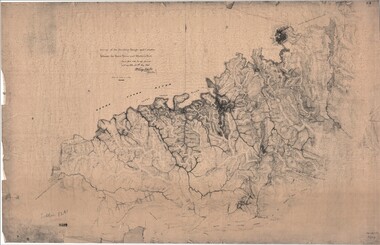
Map, Survey of Dividing Range between Yarra Yarra and Western Port - William Wedge Darke, 1843
... creeks along the higher ground that he labelled the "best line of road from Melbourne". This road was for many years the major route to Gippsland and to the higher country about Alexandra and Mansfield, sometimes known as White Horse Road, and now Maroondah Highway. Transmitted to the Surveyor General with my letter of 10th May 1843 (signed) Wm Wedge Drake, Assistant Surveyor. Scale: two inches to a mile. Descriptive remarks include upstream area of Yarra River - "impassable, appears to have been formerly a lake", and to the south - "barren and scrubby swamps ...Extract - Ringwood, Place of Many Eagles - Hugh Anderson (1974): William Wedge Darke, from Hereford, England, was a nephew of John Helder Wedge of the Port Phillip Association, who was also a surveyor. William's most important work was probably his survey of the Dividing Range and the country between the Yarra River and Western Port, completed in May 1843, and during which he made a traverse between the Mullum and Dandenong creeks along the higher ground that he labelled the "best line of road from Melbourne". This road was for many years the major route to Gippsland and to the higher country about Alexandra and Mansfield, sometimes known as White Horse Road, and now Maroondah Highway.Surveyor's relief map of features to the east of Melbourne including Yarra Yarra River, Mullum Mullum Creek, Anderson's Creek, Dandenong Creek.Transmitted to the Surveyor General with my letter of 10th May 1843 (signed) Wm Wedge Drake, Assistant Surveyor. Scale: two inches to a mile. Descriptive remarks include upstream area of Yarra River - "impassable, appears to have been formerly a lake", and to the south - "barren and scrubby swamps of the Western Port Country". Marked tracks include "best line of road from Melbourne", "track to Dandenong", "Road to Port Albert may probably be found on this range", "Best line to Upper Yarra". Several huts also marked. -
 Orbost & District Historical Society
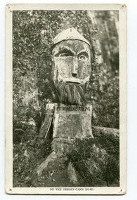
black and white photograph, 1920s
... Pons asinorum was the name given to a wooden carving made by road worker Finlay Munro in the early 1920s at Boulder Creek, on the old Princess Highway, between Orbost and Cann River. The carved face was said to mock the supervising engineer after an argument about putting the road alignment across a swamp that required new bridges. ...Orbost & District Historical Society Ruskin Street Orbost gippsland Pons asinorum was the name given to a wooden carving made by road worker Finlay Munro in the early 1920s at Boulder Creek, on the old Princess Highway, between Orbost and Cann River. The carved face was said to mock the supervising engineer after an argument about putting the road alignment across a swamp that required new bridges. ...Pons asinorum was the name given to a wooden carving made by road worker Finlay Munro in the early 1920s at Boulder Creek, on the old Princess Highway, between Orbost and Cann River. The carved face was said to mock the supervising engineer after an argument about putting the road alignment across a swamp that required new bridges. The Italian workmen had advocated for a different route to avoid the need for building new bridges across the swamp. This photograph is from a set of thirteen black and white postcards in a fold-out format.This is a photograph of an iconic tourist attraction which records the woodworking skills of workers in the early 20th century. The carving is no longer there.A small black / white photograph of a face carved into a tree stump.on front at bottom - ON THE ORBOST CANN ROADwoodcarving pons-asinorum boulder-creek-east-gippsland princess-highway -
Clunes Museum
Map, 1962
... FENTON. (2 COPIES) DETAILING SEALED ROADS, STATE FORESTS, PINE PLANTATIONS, FOREST AREAS, RAILWAYS, BOUNDARIES, TOWNSHIP AREAS CEMETERIES, CREEKS, SWAMPS AND HOUSES....FENTON. (2 COPIES) DETAILING SEALED ROADS, STATE FORESTS, PINE PLANTATIONS, FOREST AREAS, RAILWAYS, BOUNDARIES, TOWNSHIP AREAS CEMETERIES, CREEKS, SWAMPS AND HOUSES. ....1 &.2 MAP OF BALLARAT SHIRE GROUP RURAL FIRE BRIGADES FIRE CONTROL MAP. COMPILED BY C. H. FENTON. (2 COPIES) DETAILING SEALED ROADS, STATE FORESTS, PINE PLANTATIONS, FOREST AREAS, RAILWAYS, BOUNDARIES, TOWNSHIP AREAS CEMETERIES, CREEKS, SWAMPS AND HOUSES.local history, document, maps, fire brigade -
![Scene near Corranderrk Station / [by] Nicholas Caire, circa 1876](/media/collectors/550653872162f11fb04854aa/items/57774ae0d0cdd10a5c12f2d7/item-media/57774b61d0cdd10a5c132dac/item-fit-380x285.jpg?cb=6) Kew Historical Society Inc
Kew Historical Society IncPhotograph, Anglo-Australasian Photographic Company, Scene near Corranderrk Station, c. 1876
... creek first peoples aboriginal and torres straight islander printed in ink on support l.c.: SCENE NEAR "CORRANDERRK" STATION. / COPYRIGHT REGISTERED. printed in ink on support reverse c.: VIEWS OF VICTORIA. / (GENERAL SERIES.) / No. 9. / SCENE NEAR "CORRANDERRK" STATION. / This scene was taken from the hill near Rourke's Bridge, on the Healesville Road, and displays in the foreground / the River Yarra. The roadway which is seen in the mid-distance has lately been constructed by the Government, / as the old tracks which formerly existed, were liable to be swamped ...Nicholas Caire was born on Guernsey in the Channel Islands in 1837. He arrived in Adelaide with his parents in about 1860. In 1867, following photographic journeys in Gippsland, he opened a studio in Adelaide. From 1870 to 1876 he lived and worked in Talbot in Central Victoria. In 1876 he purchased T. F. Chuck's studios in the Royal Arcade Melbourne. In 1885, following the introduction of dry plate photography, he began a series of landscape series, which were commercially successful. As a photographer, he travelled extensively through Victoria, photographing places few of his contemporaries had previously seen. He died in 1918. Reference: Jack Cato, 'Caire, Nicholas John (1837–1918)', Australian Dictionary of Biography. The 1860s marked the beginning of the era of reserves and missions. Six Aboriginal reserves were established during the 1860s. These were under the control of the Board for the Protection of Aborigines. Four were Christian missions receiving government aid. These were Lake Tyers (Anglican) and Ramahyuck (Presbyterian/Moravian) in eastern Victoria for the Gunai/Kurnai clans; Ebenezer (Moravian) in north-west Victoria for the clans of the Wimmera and Lower Murray; and Lake Condah (Anglican) in south-west Victoria. The other two were secular government controlled reserves: Framlingham which, like Lake Condah, was established for the Mara-speaking Gunditjmara and Kirrae-wurrung people of south-west Victoria; and Coranderrk, located about 60 kilometres north-east of Melbourne, for the Kulin clans of central Victoria. In 1863, after a period of devastation to the Kulin people, Coranderrk was established at the junction of the Yarra River and Badger Creek. Reference: http://coranderrk.com/, accessed 24 December 2016An original, rare photograph from the series 'Views of Victoria: General Series' by the photographer, Nicholas Caire (1837-1918). The series of 60 photographs that comprise the series was issued c. 1876 and reinforced a neo-Romantic view of the Australian landscape to which a growing nationalist movement would respond. Nicholas Caire was active as a photographer in Australia from 1858 until his death in 1918. His vision of the Australian bush and pioneer life had a counterpart in the works of Henry Lawson and other nationalist poets, authors and painters.Albumen silver photograph mounted on boardprinted in ink on support l.c.: SCENE NEAR "CORRANDERRK" STATION. / COPYRIGHT REGISTERED. printed in ink on support reverse c.: VIEWS OF VICTORIA. / (GENERAL SERIES.) / No. 9. / SCENE NEAR "CORRANDERRK" STATION. / This scene was taken from the hill near Rourke's Bridge, on the Healesville Road, and displays in the foreground / the River Yarra. The roadway which is seen in the mid-distance has lately been constructed by the Government, / as the old tracks which formerly existed, were liable to be swamped by the periodical overflowing of the River. Mount / Ridell can be seen in the extreme distance immediately behind the roadway. / Corranderrk is the local habitation / for the natives of this district, and is situated on the right hand side of the picture, about a mile and a half / from the roadway. printed in ink on support reverse l.c.l.: J.W. FORBES, Agent, printed in ink on support reverse l.c.: ANGLO-AUSTRALASIAN PHOTOGRAPHIC COMPANY, MELBOURNE. printed in ink on support reverse l.c.r.: 10 Temple Court, Collins Street West.nicholas caire (1837-1918), coranderrk aboriginal station, aborigine, yarra river, badger creek, first peoples, aboriginal and torres straight islander -
 City of Kingston
Photograph - Colour, Paul Tresize, 1998
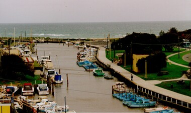
... Road, Parkdale Parkdale The name Mordialloc was derived from the name Moody Yallock, which comes from the Bunurong language. The Bunurong Peoples are the Traditional Owners of this area. The name means “high water” or “high creek”. In 1839, colonial authorities declared the mouth of the creek, and an additional 830 odd acres as an Aboriginal Reserve, although this proclamation was never gazetted. The reserved land included part of the Carrum Carrum Swamp ...The name Mordialloc was derived from the name Moody Yallock, which comes from the Bunurong language. The Bunurong Peoples are the Traditional Owners of this area. The name means “high water” or “high creek”. In 1839, colonial authorities declared the mouth of the creek, and an additional 830 odd acres as an Aboriginal Reserve, although this proclamation was never gazetted. The reserved land included part of the Carrum Carrum Swamp which was abundant with wild life and natural resources. Regular encroachments, including land sales which began in 1863, were made on the land until 1878 when the Reserve was declared closed, and the land was opened up to land sales. Market gardening and suburban house lots quickly began to develop, and Mordialloc became a renowned picnic and holiday site. Mordialloc Creek is a popular bay side destination for local and visitors, and is a site for boating, kayaking, fishing and swimming, along with many other activities.Colour photograph of Mordialloc Creek, looking out to the bay. Many small fishing and leisure craft are moored on either side of the banks of the creek. To the right hand side can be seen parklands, while the left hand side has a small inlet in which more small crafts are moored.mordialloc, bunurong, traditional owners, suburbs, boats, fishing, waterways -
 City of Kingston
Photograph - Colour, 1998
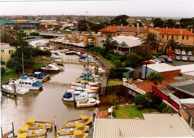
... Road, Parkdale Parkdale The name Mordialloc was derived from the name Moody Yallock, which comes from the Bunurong language. The Bunurong Peoples are the Traditional Owners of this area. The name means “high water” or “high creek”. In 1839, colonial authorities declared the mouth of the creek, and an additional 830 odd acres as an Aboriginal Reserve, although this proclamation was never gazetted. The reserved land included part of the Carrum Carrum Swamp ...The name Mordialloc was derived from the name Moody Yallock, which comes from the Bunurong language. The Bunurong Peoples are the Traditional Owners of this area. The name means “high water” or “high creek”. In 1839, colonial authorities declared the mouth of the creek, and an additional 830 odd acres as an Aboriginal Reserve, although this proclamation was never gazetted. The reserved land included part of the Carrum Carrum Swamp which was abundant with wild life and natural resources. Regular encroachments, including land sales which began in 1863, were made on the land until 1878 when the Reserve was declared closed, and the land was opened up to land sales. Market gardening and suburban house lots quickly began to develop, and Mordialloc became a renowned picnic and holiday site. Mordialloc Creek is a popular bay side destination for local and visitors, and is a site for boating, kayaking, fishing and swimming, along with many other activities.Colour photograph of Mordialloc Creek, looking inland.Small fishing and leisure boats are moored on either side of creek, with a view of the Mordialloc Bridge Hotel in the background.mordialloc, bunurong, traditional owners, suburbs, boats, fishing, waterways, hotel -
City of Kingston
Photograph - Colour, Paul Tresize, 1998
... Road, Parkdale Parkdale The name Mordialloc was derived from the name Moody Yallock, which comes from the Bunurong language. The Bunurong Peoples are the Traditional Owners of this area. The name means “high water” or “high creek”. In 1839, colonial authorities declared the mouth of the creek, and an additional 830 odd acres as an Aboriginal Reserve, although this proclamation was never gazetted. The reserved land included part of the Carrum Carrum Swamp ...The name Mordialloc was derived from the name Moody Yallock, which comes from the Bunurong language. The Bunurong Peoples are the Traditional Owners of this area. The name means “high water” or “high creek”. In 1839, colonial authorities declared the mouth of the creek, and an additional 830 odd acres as an Aboriginal Reserve, although this proclamation was never gazetted. The reserved land included part of the Carrum Carrum Swamp which was abundant with wild life and natural resources. Regular encroachments, including land sales which began in 1863, were made on the land until 1878 when the Reserve was declared closed, and the land was opened up to land sales. Market gardening and suburban house lots quickly began to develop, and Mordialloc became a renowned picnic and holiday site. Mordialloc Creek is a popular bay side destination for local and visitors, and is a site for boating, kayaking, fishing and swimming, along with many other activities.Colour photograph of Mordialloc Creek, looking inland. Boats are moored on either side of the creek and the Bridge Hotel is visible in the background.mordialloc, bunurong, traditional owners, suburbs, boats, fishing, waterways, hotel -
 City of Kingston
Photograph - Colour, Paul Tresize, 1998
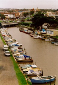
... Road, Parkdale Parkdale The name Mordialloc was derived from the name Moody Yallock, which comes from the Bunurong language. The Bunurong Peoples are the Traditional Owners of this area. The name means “high water” or “high creek”. In 1839, colonial authorities declared the mouth of the creek, and an additional 830 odd acres as an Aboriginal Reserve, although this proclamation was never gazetted. The reserved land included part of the Carrum Carrum Swamp ...The name Mordialloc was derived from the name Moody Yallock, which comes from the Bunurong language. The Bunurong Peoples are the Traditional Owners of this area. The name means “high water” or “high creek”. In 1839, colonial authorities declared the mouth of the creek, and an additional 830 odd acres as an Aboriginal Reserve, although this proclamation was never gazetted. The reserved land included part of the Carrum Carrum Swamp which was abundant with wild life and natural resources. Regular encroachments, including land sales which began in 1863, were made on the land until 1878 when the Reserve was declared closed, and the land was opened up to land sales. Market gardening and suburban house lots quickly began to develop, and Mordialloc became a renowned picnic and holiday site. Mordialloc Creek is a popular bay side destination for local and visitors, and is a site for boating, kayaking, fishing and swimming, along with many other activities.Colour photograph of Mordialloc Creek with boats moored on both sides of the street and Pompei's boat yard visible on the right hand side of the creek., Main Street and St Brigid's Catholic Church are visible in backgroundmordialloc, bunurong, traditional owners, suburbs, boats, fishing, waterways, hotel, church -
City of Kingston
Photograph - Colour, Paul Tresize, 1998
... Road, Parkdale Parkdale The name Mordialloc was derived from the name Moody Yallock, which comes from the Bunurong language. The Bunurong Peoples are the Traditional Owners of this area. The name means “high water” or “high creek”. In 1839, colonial authorities declared the mouth of the creek, and an additional 830 odd acres as an Aboriginal Reserve, although this proclamation was never gazetted. The reserved land included part of the Carrum Carrum Swamp ...The name Mordialloc was derived from the name Moody Yallock, which comes from the Bunurong language. The Bunurong Peoples are the Traditional Owners of this area. The name means “high water” or “high creek”. In 1839, colonial authorities declared the mouth of the creek, and an additional 830 odd acres as an Aboriginal Reserve, although this proclamation was never gazetted. The reserved land included part of the Carrum Carrum Swamp which was abundant with wild life and natural resources. Regular encroachments, including land sales which began in 1863, were made on the land until 1878 when the Reserve was declared closed, and the land was opened up to land sales. Market gardening and suburban house lots quickly began to develop, and Mordialloc became a renowned picnic and holiday site. Mordialloc Creek is a popular bay side destination for local and visitors, and is a site for boating, kayaking, fishing and swimming, along with many other activities.Colour photograph of Mordialloc Creek with boats moored on both sides of the street and Pompei's boat yard visible on the right hand side of the creek., Main Street and St Brigid's Catholic Church are visible in background.mordialloc, bunurong, traditional owners, boats, fishing -
City of Kingston
Photograph - Colour, 31 January 1993
... Patterson Lakes Seaford Kananook Creek Carrum Carrum Swamp Canals and waterways Black typed lettering on white adhesive label: 31.1.93 Black typed lettering on white adhesive label: 27E/7140 31/1/93 12.55 pm Black typed lettering on white label: 7140 Yellow round adhesive label located on left side Laminated colour aerial photograph of the Carrum and Patterson Lakes region within City of Kingston. This 1993 image includes Patterson River Secondary College, Roy Dore Reserve, Kananook Creek and Nepean Highway. The railway line can be seen as it veers inland from Eel Race Road ...Patterson Lakes is a suburb in the City of Kingston that is built one kilometre upstream of the mouth of the Patterson River. The area is bordered by the Patterson River and Eel Race Drain which enters the Kananook Creek. The suburb consists predominantly of newer housing developments and the tidal canal system of the development joins Port Phillip Bay. Patterson Lakes and the Kananook Creek were previously part of the extensive Carrum Carrum Swamp. The area was once a source of fish and eels for the Mayone-Bulluk clan of the Bunurong people. Over time the area was drained and in 1973 investigations commenced into the development of a unique residential area that would be built adjacent to canals and waterways. It was originally proposed to be known as "Gladesville". The development would give the suburb's homeowners access to Port Phillip Bay "from their back door". Circa 1974, the area was rezoned from rural to residential and named Patterson Lakes. Development has been continuous since the 1970s with construction of residential housing, schools, shopping centres, marinas, a hotel and library.Laminated colour aerial photograph of the Carrum and Patterson Lakes region within City of Kingston. This 1993 image includes Patterson River Secondary College, Roy Dore Reserve, Kananook Creek and Nepean Highway. The railway line can be seen as it veers inland from Eel Race Road, Seaford. The section of Ocean Reef Drive and Palm Beach Drive in Patterson Lakes appears to be a recent development with many spare blocks and new houses under construction.Black typed lettering on white adhesive label: 31.1.93 Black typed lettering on white adhesive label: 27E/7140 31/1/93 12.55 pm Black typed lettering on white label: 7140 Yellow round adhesive label located on left sidepatterson lakes, seaford, kananook creek, carrum carrum swamp, canals and waterways -
City of Kingston
Photograph - Colour, c. 1993
... Patterson Lakes Seaford Kananook Creek Carrum Carrum Swamp Canals and waterways Laminated colour aerial photograph of the Carrum and Patterson Lakes region within City of Kingston. This 1993 image includes Patterson River Secondary College, Roy Dore Reserve, Kananook Creek and Nepean Highway. The railway line can be seen as it veers inland from Eel Race Road ...Patterson Lakes is a suburb in the City of Kingston that is built one kilometre upstream of the mouth of the Patterson River. The area is bordered by the Patterson River and Eel Race Drain which enters the Kananook Creek. The suburb consists predominantly of newer housing developments and the tidal canal system of the development joins Port Phillip Bay.Patterson Lakes and the Kananook Creek were previously part of the extensive Carrum Carrum Swamp. The area was once a source of fish and eels for the Mayone-Bulluk clan of the Bunurong people. Over time the area was drained and in 1973 investigations commenced into the development of a unique residential area that would be built adjacent to canals and waterways. It was originally proposed to be known as "Gladesville". The development would give the suburb's homeowners access to Port Phillip Bay "from their back door". Circa 1974, the area was rezoned from rural to residential and named Patterson Lakes. Development has been continuous since the 1970s with construction of residential housing, schools, shopping centres, marinas, a hotel and library.Laminated colour aerial photograph of the Carrum and Patterson Lakes region within City of Kingston. This 1993 image includes Patterson River Secondary College, Roy Dore Reserve, Kananook Creek and Nepean Highway. The railway line can be seen as it veers inland from Eel Race Road, Seaford. The section of Palm Beach Drive, Curlew Point Drive, Snapper Point Drive, Clipper Island and Myola Street in Patterson Lakes appears to be a recent development with many spare blocks and new houses under construction.patterson lakes, seaford, kananook creek, carrum carrum swamp, canals and waterways -
Eltham District Historical Society Inc
Document - Folder, Thomson, Donald
... Creek Gippsland...."Donald Tomson in Arnhem Land"...."N.T.S.R.U. 1941-1943"..."Thomson of Arnhem Land"...Victorian Aborigines Welfare Board...Thomson Collection Museum Victoria...Mia Mia Aboriginal Art Gallery...Louise Thomson-Officer...Marcia Langton...Su baker...Lake Tyers Victorian Aboriginal Reserve Gippsland...Robert Macklin...Yintjingga people...29 Edwin Road Templestowe...Royal Geographic Society...Nicholas Peterson...Mapoon Mission...Wongo Aboriginal man...Wuluwirr Aboriiginal man...Mattuwa Aboriginal man...Mauwunbol Aboriginal man...Munguyuma Aboriginal man...Dja Dja Wurrung people...Gavin Jennings...Gary Murray...Film "Ten Canoes"...Galanbingu people...Mandallpuy people...Djinba people...Rolf de Heer...Arnhem Land...Arafura Swamp...Creek Gippsland ."Donald Tomson in Arnhem Land". "N.T.S.R.U. 1941-1943" "Thomson of Arnhem Land" Victorian Aborigines Welfare Board Thomson Collection Museum Victoria Mia Mia Aboriginal Art Gallery Louise Thomson-Officer Marcia Langton Su baker Lake Tyers Victorian Aboriginal Reserve Gippsland Robert Macklin Yintjingga people 29 Edwin Road Templestowe Royal Geographic Society Nicholas Peterson Mapoon Mission Wongo Aboriginal man Wuluwirr Aboriiginal man Mattuwa Aboriginal man Mauwunbol Aboriginal man Munguyuma Aboriginal man Dja Dja Wurrung people Gavin Jennings Gary Murray Film "Ten Canoes" Galanbingu people Mandallpuy people Djinba people Rolf de Heer Arnhem Land Arafura Swamp Ramingining Caledon Bay Lindy Allen Bunjilaka Centre Newspaper clippings, A4 photocopies, etc Thomson, Donald Document Folder ...Anthropologist and Aboriginal activist Donald Thomson later lived in Eltham with wife Dorita. Contents Photocopy of photograph of Thomson family at "The Oaks", Kinglate 11 November 1891. Photocopy of old photograph of "Worlingworth", home of Donald Thomson. Booklet: "N.T.S.R.U. 1941-1943: text and photographs from the report of Sqn Leader Donald Thomson." Yirrkale Literature Production Centre, 1992. Photocopy of Australian Dictionary of Biography (Vol.16, pp385-386), entry for Thomson, Donald Finlay Fergusson. Newspaper article: "Drought close to city", no source, no date. Donald Thomson wants South Riding of Eltham declared a drought area, photograph of Elaine Thomson. Newspaper article: "Professor dies", The Post, 27 1970. Obituary of Donald Thomson. Photocopy of extracts from "Donald Thomson in Arnhem Land" 1983: Chapter "Donald Thomson: A biographical Sketch". pp1-15; Map; Notes on sources pp141-142. Newspaper article: "Memoirs of an advocate for Aboriginal rights", Diamond Valley News, 8 March 1983. Interview of Dorita Thomson, widow of Donald Thomson, about him and house "Worlingworth". Newspaper article: "Australia's secret Aboriginal 'army". Herald, 2 June 1983. Donald Thomson's life and work, and the book about it, "Donald Thomson of Arnhem Land". Invitation to exhibition of photographs by Donald Thomson, Brighton City Library, 22 July 1983. Publicity for film "Thomson of Arnhem Land" with note from Bruce Nixon, 8 June 2000. Newspaper article: "A crusader before his time", Diamond Valley News, 9 August 2000. Details of life and work of Donald Thomson. Newspaper article: "Outback part. of his life", Diamond Valley News, 9 August 2000. Interview of Dorita Thomson about Donald Thomson's life and work. Newspaper article: "Museum and Aboriginies to meet in stand-off over heritage items", The Age, 29 July 2004. Bark paintings on loan from British Museum in dispute. Magazine article: "Keeping time with Rolf", Time, 20 March 2006. Mentions of Donald Thomson. Newspaper advertisement: "The Thomson House" Templestowe, Emerson Oliver Estate Agent. The Weekly Review, no date (possibly 2017). Flier: "The Thomson House" Templestowe, Emerson Oliver Estate Agent. Newspaper article: "Once upon a time an anthropolgist watched men hunt in 10 canoes", The Age, 16 December 2006. Donald Thomson's work and a new film "Ten Canoes". Newspaper article: "A life's work offers forgotten link to the cultural wealth of nation's first people", The Age, 23 December 2024. The Donald Thomson Ethnohistory Collection. Newspaper clippings, A4 photocopies, etcdonald thomson, northern territory special reconnaissance unit, donald finlay fergusson thomson, "the oaks" kinglake, "worlingworth" eltham, elaine thomson, louise thomson, rosemary thomson, dorita thomson, st margaret's church of england eltham, australian institute of aboriginal studies, brandy creek gippsland, ."donald tomson in arnhem land"., "n.t.s.r.u. 1941-1943", "thomson of arnhem land", victorian aborigines welfare board, thomson collection museum victoria, mia mia aboriginal art gallery, louise thomson-officer, marcia langton, su baker, lake tyers victorian aboriginal reserve gippsland, robert macklin, yintjingga people, 29 edwin road templestowe, royal geographic society, nicholas peterson, mapoon mission, wongo aboriginal man, wuluwirr aboriiginal man, mattuwa aboriginal man, mauwunbol aboriginal man, munguyuma aboriginal man, dja dja wurrung people, gavin jennings, gary murray, film "ten canoes", galanbingu people, mandallpuy people, djinba people, rolf de heer, arnhem land, arafura swamp, ramingining, caledon bay, lindy allen, bunjilaka centre