Showing 81 items matching "swimming facilities"
-
 The Beechworth Burke Museum
Photograph, 1960s
... ...swimming facilities...It involved raising the banks to five feet to provide swimming facilities, paddling pool and caravan park. ...It involved raising the banks to five feet to provide swimming facilities, paddling pool and caravan park. ...Taken around 1960s, this photograph shows the banks of Lake Sambell. Lake Sambell is named after Mr. L. H. Sambell who was instrumental in the lake's formation. Lake Sambell is the original site of the open sluice operation of Rocky Mountain Mining Company in the 1800s and the early 1900s. In the early 1920s, it was reconstructed as a recreational lake and was formally opened to public on 6 October 1928. The opening event was attended by townspeople and Beechworth's Minister of Lands Mr. Bailey. In the late 1930s to early 1940s, Lake Sambell redeveloped. The first development aimed to raise the banks by six feet to double its present area and to make the water cleaner. Another redevelopment in the 1940s was made possible by the Beechworth and District Progress Association. It involved raising the banks to five feet to provide swimming facilities, paddling pool and caravan park. This photograph holds Historic significance because of its connection to the development of Beechworth district.Sepia rectangular photograph printed on matte photographic paperObverse: Reverse: 3533 /beechworth, water scheme, water reserve, catchments, beechworth water reserve, beechworth catchments, municipal council, lakes, reserve, water supply, political projects, environmental changes, mr. l. h. sambell, sambell, rocky mountain mining company, recreational lake, minister of lands, mr. bailey, swimming pool, paddling pool, caravan park, swimming facilities, lake redevelopment, funding -
 Sunshine and District Historical Society Incorporated
Photograph - Swimming Pool Kororoit Creek, 1935
... Photograph of swimming facilities of pool Kororoit Creek near Forrest Street Set up by Sunshine Swimming Club in 1930s...Swimming Pool Kororoit Creek Photograph of swimming facilities of pool Kororoit Creek near Forrest Street Set up by Sunshine Swimming Club in 1930s Swimming Pool Kororoit Creek Photograph Swimming Pool Kororoit Creek ...Photograph of swimming facilities of pool Kororoit Creek near Forrest Street Set up by Sunshine Swimming Club in 1930sswimming pool, kororoit creek -
 Emerald Museum & Nobelius Heritage Park
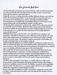
Photograph - Photographic print of the Emerald Country Club ornamental lake, THE LAKE FROM THE CLUB HOUSE - 1929, c.1920s-1930s
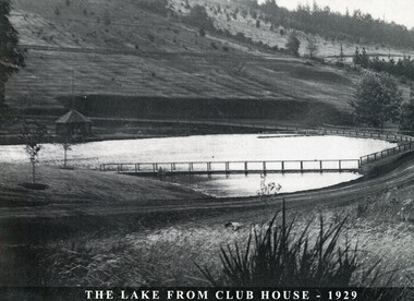
... It offered accommodation and dining, a nine-hole golf course, tennis courts, a bowling green as well as swimming and fishing facilities. This photograph of the ornamental lake was taken in 1929....It offered accommodation and dining, a nine-hole golf course, tennis courts, a bowling green as well as swimming and fishing facilities. This photograph of the ornamental lake was taken in 1929. ...The Emerald Country Club was originally set up as a country retreat for the wealthy in the late 1920s. It was modelled on American country clubs and it was situated on land formerly owned by the Gembrook Nurseries. It offered accommodation and dining, a nine-hole golf course, tennis courts, a bowling green as well as swimming and fishing facilities. This photograph of the ornamental lake was taken in 1929.This photograph evokes the iconic and beautiful former Emerald Country Club in its earlier days.Black and white photographic print of the ornamental lake of the former Emerald Country Club and environs looking west towards the pavilion next to the lake and Lakeside Drive. The photograph has a printed title at the bottom. On bottom of photograph: 'THE LAKE FROM CLUB HOUSE - 1929'emerald country club, gembrook nurseries, golf -
 Emerald Museum & Nobelius Heritage Park
Photograph - Photographic print of the Emerald Country Club, LOOKING FROM THE ROUGH, TOP SIDE OF THE 3rd FAIRWAY -1934, 1934
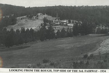
... It offered accommodation and dining, a nine-hole golf course, tennis courts, a bowling green as well as swimming and fishing facilities. This photograph of the 3rd fairway and the club house was taken in 1934....It offered accommodation and dining, a nine-hole golf course, tennis courts, a bowling green as well as swimming and fishing facilities. This photograph of the 3rd fairway and the club house was taken in 1934. ...The Emerald Country Club was originally set up as a country retreat for the wealthy in the late 1920s. It was modelled on American country clubs and it was situated on land formerly owned by the Gembrook Nurseries. It offered accommodation and dining, a nine-hole golf course, tennis courts, a bowling green as well as swimming and fishing facilities. This photograph of the 3rd fairway and the club house was taken in 1934.This photograph evokes the iconic and beautiful former Emerald Country Club in its earlier days.Black and white photographic print of the former Emerald Country Club taken from the top side of the 3rd fairway. The club house is in the middle distance. The print has been laminated with a printed title at the bottom.At bottom of print: 'LOOKING FROM THE ROUGH, TOP SIDE OF THE 3rd. FAIRWAY - 1934'emerald country club, gembrook nurseries, golf -
 Emerald Museum & Nobelius Heritage Park
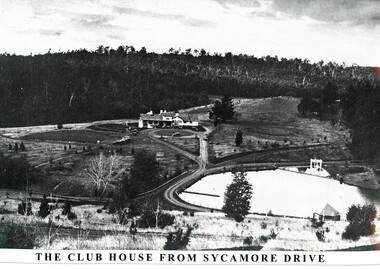
Photograph - Photographic print of Emerald Country Club, The Club House From Sycamore Drive, c.1920s-1930s
... It offered accommodation and dining, a nine-hole golf course, tennis courts, a bowling green as well as swimming and fishing facilities. This photograph shows the club house and environs including the ornamental lake in the foreground....It offered accommodation and dining, a nine-hole golf course, tennis courts, a bowling green as well as swimming and fishing facilities. This photograph shows the club house and environs including the ornamental lake in the foreground. ...The Emerald Country Club was originally set up as a country retreat for the wealthy in the late 1920s. It was modelled on American country clubs, and it was situated on land formerly owned by the Gembrook Nurseries. It offered accommodation and dining, a nine-hole golf course, tennis courts, a bowling green as well as swimming and fishing facilities. This photograph shows the club house and environs including the ornamental lake in the foreground.This photograph captures the iconic and beautiful former Emerald Country Club in its earlier days.Black and white photographic print of the former Emerald Country Club showing the club house in the centre and the lake in the right foreground. The print has been laminated with a printed title at the bottom. On the bottom of print: 'THE CLUB HOUSE FROM SYCAMORE DRIVE'emerald country club, gembrook nurseries, golf -
 Emerald Museum & Nobelius Heritage Park
Photograph - Photographic print of the ornamental lake at the Emerald Country Club, THE LAKE AND THE CLUB HOUSE - 1929, 1929
... It offered accommodation and dining, a nine-hole golf course, tennis courts, a bowling green as well as swimming and fishing facilities. This photograph focuses on the ornamental lake in front of the club house and was taken in 1929....It offered accommodation and dining, a nine-hole golf course, tennis courts, a bowling green as well as swimming and fishing facilities. This photograph focuses on the ornamental lake in front of the club house and was taken in 1929. ...The Emerald Country Club was originally set up as a country retreat for the wealthy in the late 1920s. It was modelled on American country clubs and it was situated on land formerly owned by the Gembrook Nurseries. It offered accommodation and dining, a nine-hole golf course, tennis courts, a bowling green as well as swimming and fishing facilities. This photograph focuses on the ornamental lake in front of the club house and was taken in 1929.This photograph evokes the iconic and beautiful former Emerald Country Club in its earlier days.Black and white photographic print of the ornamental lake at the former Emerald Country Club - the club house with smoking chimneys is in the background. The print has been laminated and has a printed title at the bottom. On bottom of image: 'THE LAKE AND THE CLUB HOUSE - 1929'emerald country club, gembrook nurseries, golf -
 Glen Eira Historical Society
Document - SWIMMING POOLS
... This file contains eight items pertaining to Caulfield’s swimming pools: 1/Report entitled ‘Future Options in the Provision of Public Swimming Facilities in the City of Caulfield’, dated March, 1983, prepared by Caulfield Planning Department of approx. 50 pages. 2/Photocopy of an article from ‘Port Phillip/Caulfield Leader’, dated 11/02/2002, concerning the cost of pool maintenance. 3/Public consultation paper entitled ‘Pools Past, Present and Future’, dated 07/03/2006, prepared by Glen Eira City Council, of 24 pages. 4/Article dated 08/03/2006 from ‘The Age’ concerning Glen Eira Residents’ fight to save swimming pools in Glen Eira. 5/Two page printed leaflet entitled ‘Save Our Pools’ dated 18/03/2006 produced by the northern memorial action group. 6/Three page printed survey sheet entitled ‘The East Bentleigh Swim Centre; an assessment of community needs’ undated, with accompanying return envelope. 7/Front page article from the ‘Glen Eira Caulfield Leader’ dated 04/04/2006 entitled ‘Save Our Pools’. 8/An article from ‘Port Phillip/Caulfield Leader’ dated 04/04/2006, concerning a former Glen Eira Council employee’s information about the Council’s pools report and a ‘letter to the editor’ by Sue Litchfield of Elsternwick containing her view of Glen Eira’s pool requirements....Glen Eira Historical Society 965 Glen Huntly Rd Caulfield VIC 3162 melbourne This file contains eight items pertaining to Caulfield’s swimming pools: 1/Report entitled ‘Future Options in the Provision of Public Swimming Facilities in the City of Caulfield’, dated March, 1983, prepared by Caulfield Planning Department of approx. 50 pages. 2/Photocopy of an article from ‘Port Phillip/Caulfield Leader’, dated 11/02/2002, concerning the cost of pool maintenance. 3/Public consultation paper entitled ‘Pools Past, Present and Future’, dated 07/03/2006, prepared by Glen Eira City Council, of 24 pages. 4/Article dated 08/03/2006 from ‘The Age’ concerning Glen Eira Residents’ fight to save swimming pools in Glen Eira. 5/Two page printed leaflet entitled ‘Save Our Pools’ dated 18/03/2006 produced by the northern memorial action group. 6/Three page printed survey sheet entitled ‘The East Bentleigh Swim Centre; an assessment of community needs’ undated, with accompanying return envelope. 7/Front page article from the ‘Glen Eira Caulfield Leader’ dated 04/04/2006 entitled ‘Save Our Pools’. 8/An article from ‘Port Phillip/Caulfield Leader’ dated 04/04/2006, concerning a former Glen Eira Council employee’s information about the Council’s pools report and a ‘letter to the editor’ by Sue Litchfield of Elsternwick containing her view of Glen Eira’s pool requirements. ...This file contains eight items pertaining to Caulfield’s swimming pools: 1/Report entitled ‘Future Options in the Provision of Public Swimming Facilities in the City of Caulfield’, dated March, 1983, prepared by Caulfield Planning Department of approx. 50 pages. 2/Photocopy of an article from ‘Port Phillip/Caulfield Leader’, dated 11/02/2002, concerning the cost of pool maintenance. 3/Public consultation paper entitled ‘Pools Past, Present and Future’, dated 07/03/2006, prepared by Glen Eira City Council, of 24 pages. 4/Article dated 08/03/2006 from ‘The Age’ concerning Glen Eira Residents’ fight to save swimming pools in Glen Eira. 5/Two page printed leaflet entitled ‘Save Our Pools’ dated 18/03/2006 produced by the northern memorial action group. 6/Three page printed survey sheet entitled ‘The East Bentleigh Swim Centre; an assessment of community needs’ undated, with accompanying return envelope. 7/Front page article from the ‘Glen Eira Caulfield Leader’ dated 04/04/2006 entitled ‘Save Our Pools’. 8/An article from ‘Port Phillip/Caulfield Leader’ dated 04/04/2006, concerning a former Glen Eira Council employee’s information about the Council’s pools report and a ‘letter to the editor’ by Sue Litchfield of Elsternwick containing her view of Glen Eira’s pool requirements.city of caulfield, caulfield, glen eira, caulfield planning department, palmer david, caulfield memorial pool, erlich noel, newton andrew, bentleigh east swim centre, city of glen eira, glen eira town hall, carnegie library, carnegie, shepparson avenue, mckinnon secondary college, east boundary road, koornang road, east bentleigh, feldman david, northern memorial pool, centre road, bentleigh, hudson rob, magee jim, antoine marc, swimming pools, olympic pools, public baths, baths, memorials, local government, northern memorial action group, community groups -
 Emerald Museum & Nobelius Heritage Park
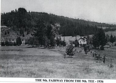
Photograph - Photographic print of Emerald Country Club, THE 9th FAIRWAY FROM THE 9th TEE - 1936, 1936
... It offered accommodation and dining, a nine-hole golf course, tennis courts, a bowling green as well as swimming and fishing facilities. This photograph taken in 1936 shows a side view of the club house taken from the 9th tee....It offered accommodation and dining, a nine-hole golf course, tennis courts, a bowling green as well as swimming and fishing facilities. This photograph taken in 1936 shows a side view of the club house taken from the 9th tee. ...The Emerald Country Club was originally set up as a country retreat for the wealthy in the late 1920s. It was modelled on American country clubs and it was situated on land formerly owned by the Gembrook Nurseries. It offered accommodation and dining, a nine-hole golf course, tennis courts, a bowling green as well as swimming and fishing facilities. This photograph taken in 1936 shows a side view of the club house taken from the 9th tee.This photograph captures the iconic and beautiful former Emerald Country Club in its earlier days.Black and white photographic print of the former Emerald Country Club showing club house in centre and the 9th fairway. It is laminated with a printed title at the bottom.At bottom of image: 'THE 9th FAIRWAY FRORM THE 9th TEE - 1936'emerald country club, gembrook nurseries, golf -
 The Beechworth Burke Museum
Photograph, 1960s
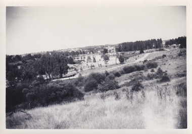
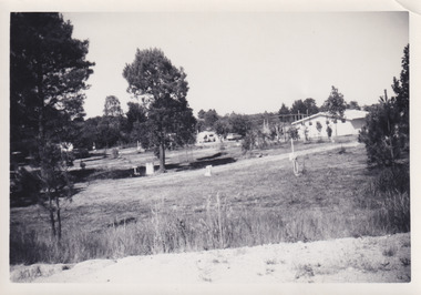
... Throughout the 1940s the Beechworth Swimming Club sort to address the structural engineering issues and improve swimming facilities at the lake. R.E. Carter, similar to L.H. ...Throughout the 1940s the Beechworth Swimming Club sort to address the structural engineering issues and improve swimming facilities at the lake. R.E. Carter, similar to L.H. ...This photograph was taken in the 1960s at Lake Sambell and is a view across the lake from the east side, the photo was taken during a period of improvements to the lake and surrounding area. Lake Sambell is an artificial lake that was created on the site of the old Rocky Mountain Mining Company workings and was officially opened by Minister for Lands, Mr Baily, on October 5, 1928. The disused and unattractive remains of the mine were converted into a recreational area intended for swimming, boating, and fishing. The lake is named after Mr L.H. Sambell, shire engineer and secretary of the Forward Beechworth Committee, who advocated for the enhancement of Beechworth into a tourist destination and was central to the planning and establishment of the lake. Funding for the project was raised through both competition funds and donations. Since the construction in 1928 several engineering issues have arisen. In 1939 the water levels were low, and the lake was considered both an eyesore and ‘mudhole’, Beechworth Shire Council sort funding to raise the height of the lake six feet to improve the quality of water. Throughout the 1940s the Beechworth Swimming Club sort to address the structural engineering issues and improve swimming facilities at the lake. R.E. Carter, similar to L.H. Sambell, was a shire engineer who advocated the importance of positioning Beechworth as a tourist destination. Carter held the position of shire engineer from 1954-63 and organised many improvements to the Lake Sambell area including the caravan park in 1959, the lake swimming pool in 1961, water skiing and boating facilities, and increased the lake surface area in 1964. These improvements to the lake also reflect an increase in leisure time and access to travel during a period of post-war prosperity in Australia during the 1950s and 60s. This photograph is of historical significance as it documents Lake Sambell in the 1960s after a series of enhancements to the lake area to improve its appearance and usability for both the people of Beechworth and tourists. It is also of social significance in providing an insight into the increase in leisure time and access to travel during a period of post-war prosperity. Black and white rectangle photograph printed on photographic paper and unmounted.Reverse: 3534 C798lake sambell, l.h. sambell, r.e. carter, rocky mountain mining company, forward beechworth committee, beechworth swimming club, wallace park lake sambell development scheme, lake sambell caravan park, beechworth 1960s, lake sambell swimming pool, lake sambell boating, lake sambell fishing, swimming, boating, water skiing, fishing, post-war prosperity, minister of lands, artificial lake, open cut sluice mine, lake -
 The Beechworth Burke Museum
Photograph, 1960s
... Throughout the 1940s the Beechworth Swimming Club tried to raise awareness and funds to address the structural engineering issues, raise the water levels, and improve swimming facilities at the lake. Beechworth Swimming Club hosted a swimming carnival at the lake in 1948, but it was decided due to several issues at the event, that no further carnivals would be hosted until necessary improvements were made to the area. ...Throughout the 1940s the Beechworth Swimming Club tried to raise awareness and funds to address the structural engineering issues, raise the water levels, and improve swimming facilities at the lake. Beechworth Swimming Club hosted a swimming carnival at the lake in 1948, but it was decided due to several issues at the event, that no further carnivals would be hosted until necessary improvements were made to the area. ...This photograph was taken in the 1960s of the Lake Sambell Swimming Pool with the lake itself in the background. The swimming pool area has multiple features including park benches, a water slide, and a fenced area with a diving pontoon for lap swimming and racing. Lake Sambell Swimming Pool was completed in 1961, driven largely by R.E. Carter, Beechworth shire engineer from 1954-63. Carter advocated for improvements to the lake and surrounding area in order to encourage tourism in Beechworth. The opening of the swimming pool was part of many improvements to Lake Sambell made during this period by Carter including establishing the caravan park in 1959, water skiing and boating facilities, and increasing the lake surface in 1964. These improvements were financed mainly by grants from the Tourist Development Authority. For many decades, members of the local Beechworth community had advocated for the development of swimming pool at the lake that would include a safe wadding area and Olympic standard lanes for laps and races. Throughout the 1940s the Beechworth Swimming Club tried to raise awareness and funds to address the structural engineering issues, raise the water levels, and improve swimming facilities at the lake. Beechworth Swimming Club hosted a swimming carnival at the lake in 1948, but it was decided due to several issues at the event, that no further carnivals would be hosted until necessary improvements were made to the area. Swimming pools, both artificial and built into natural environments, were an extremely popular public space throughout the 20th century in Australia. Increasing in accessibility and popularity through such developments as less restrictive swimming outfits during 1920s, public building works during the 1920s and 30s, and an increase in leisure time during a period of post-war prosperity. This photograph is of historical significance as it documents the newly established Lake Sambell Swimming Pool in the 1960s after many decades of discussion and proposals around creating a safe swimming area at the lake. Further, this photograph provides important social insights into the facilities and uses of this pool in the 1960s, and underlines the significant role public swimming pools have played in Australian social and recreational experiences. Black and white rectangle photograph printed on photographic paper and unmounted.Reverse: 3537 / C798lake sambell swimming pool, lake sambell water slide, water slide 1960s, lake sambell pontoon, lake sambell 1960s, lake swimming pool, lake swimming, beechworth swimming club, swimming pools in the 20th century, r.e. carter, tourist development authority, beechworth 1960s, lake water slide, lake sambell, wadding pool, swimming, swimming pool 1960s, leisure, recreation 1960s -
 Emerald Museum & Nobelius Heritage Park
Essay - Local history typescript, The Emerald Golf Club, c.1990s
... It offered accommodation and dining, a nine-hole golf course, tennis courts, a bowling green as well as swimming and fishing facilities. By the 1970s the exclusive nature of the club had been relaxed and the golf course expanded. ...It offered accommodation and dining, a nine-hole golf course, tennis courts, a bowling green as well as swimming and fishing facilities. By the 1970s the exclusive nature of the club had been relaxed and the golf course expanded. ...The Emerald Country Club was originally set up as a country retreat for the wealthy in the late 1920s. It was modelled on American country clubs and it was situated on land formerly owned by the Gembrook Nurseries. It offered accommodation and dining, a nine-hole golf course, tennis courts, a bowling green as well as swimming and fishing facilities. By the 1970s the exclusive nature of the club had been relaxed and the golf course expanded. Its complex history since then is detailed in the typescript. This short essay describes the history of golf in Emerald.A typed A4 page entitled: 'The Emerald Golf Club'. The font is of a cursive style.emerald country club, gembrook nurseries, golf, emerald golf club -
 The Beechworth Burke Museum
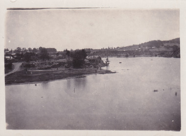
Photograph, c1960
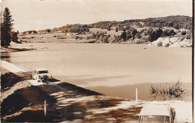
... As well as improving swimming facilities, funds were raised to install a caravan park facility near the lake. ...As well as improving swimming facilities, funds were raised to install a caravan park facility near the lake. ...The photograph depicts a view across the water at Lake Sambell. The image dates from approximately 1960. The present day park and reserve occupies the site of the former Rocky Mountain Mining Company, an open-cut sluice mine that began operations in the mid-Nineteenth Century and operated until the early 1900s, through the peak of Victoria’s Gold Rush. It was converted into a park and leisure area in the 1920s. Lake Sambell was formally opened to the public on Friday 5th October 1928 and was opened by the Victorian Government’s Minister of Lands, Mr Bailey, as part of initiatives to boost the economies and development of country towns. The lake was named after Mr L.H. Sambell, a shire engineer and secretary of the Forward Beechworth Committee who was involved in promoting the transformation of the mining site and promoting plantation forestry and tourism as alternative industries. £300 to begin the process was provided by Mr J. McConvill, a former resident of Beechworth, who is remembered in a street name adjacent to the lake. Residents of Beechworth have worked to raise funds to improve the Lake Sambell reserve several times, such as efforts in the 1930s and 1940s to raise the banks several feet to deepen the water for swimming purposes. Fundraising campaigns include the ‘Ugly Man’ competition conducted on behalf of the Wallace Park-Lake Sambell Development Scheme. The latter competition was run by the Fire Brigade Bend’s team as part of a larger competition called the ‘Mile of Pennies’; it was won by Mr Len Knight of Beechworth’s Commercial Hotel. The ‘Mile of Pennies’ was conducted at a Carnival held on New Year’s Eve, 1947. It was proposed by the Beechworth and District Progress Association. As well as improving swimming facilities, funds were raised to install a caravan park facility near the lake. Funds were also donated by commercial entities, such as £250 received from Zwar Bros. Pty Ltd. The photograph is significant as it shows the level of development of Beechworth in the early to mid-Twentieth Century. Sepia rectangular photograph printed on matte photographic paperObverse: nil. Reverse: 3470 / Velox (paper mark)beechworth, beechworth lake, lake sambell, lake, beechworth and district progress association, forward beechworth committee, ugly man, mile of pennies, wallace park lake sambell development scheme, wallace park-lake sambell development scheme, zwar bros, zwar, l.h. sambell, j. mcconvill, minister of lands, commercial hotel, len knight, rocky mountain mining company, rocky mountain mining co, gold rush, redevelopment, transformation, community fundraising -
 The Beechworth Burke Museum
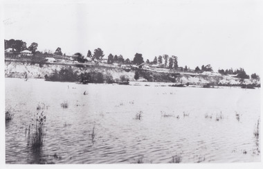
Photograph, c1960
... As well as improving swimming facilities, funds were raised to install a caravan park facility near the lake. ...As well as improving swimming facilities, funds were raised to install a caravan park facility near the lake. ...The photographs in this set depict views across the water at Lake Sambell. The images date from approximately 1960. The present day park and reserve occupies the site of the former Rocky Mountain Mining Company, an open-cut sluice mine that began operations in the mid-19th Century and operated until the early 1900s, through the peak of Victoria’s Gold Rush. It was converted into a park and leisure area in the 1920s. Lake Sambell was formally opened to the public on Friday 5th October 1928 and was opened by the Victorian Government’s Minister of Lands, Mr Bailey, as part of initiatives to boost the economies and development of country towns. The lake was named after Mr L.H. Sambell, a shire engineer and secretary of the Forward Beechworth Committee who was involved in promoting the transformation of the mining site and promoting plantation forestry and tourism as alternative industries. £300 to begin the process was provided by Mr J. McConvill, a former resident of Beechworth, who is remembered in a street name adjacent to the lake. Residents of Beechworth have worked to raise funds to improve the Lake Sambell reserve several times, such as efforts in the 1930s and 1940s to raise the banks several feet to deepen the water for swimming purposes. Fundraising campaigns include the ‘Ugly Man’ competition conducted on behalf of the Wallace Park-Lake Sambell Development Scheme. The latter competition was run by the Fire Brigade Bend’s team as part of a larger competition called the ‘Mile of Pennies’; it was won by Mr Len Knight of Beechworth’s Commercial Hotel. The ‘Mile of Pennies’ was conducted at a Carnival held on New Year’s Eve, 1947. It was proposed by the Beechworth and District Progress Association. As well as improving swimming facilities, funds were raised to install a caravan park facility near the lake. Funds were also donated by commercial entities, such as £250 received from Zwar Bros. Pty Ltd.The photographs are significant as they show the level of development in Beechworth in the middle of the Twentieth Century. Four sepia and black and white rectangular photographs printed on matte photographic paper. 3469.1: Obverse: nil Reverse: 3469-1 3469.2: Obverse: nil Reverse: 3469-2 3469.3: Obverse: nil Reverse: 3469-3 3469.4: Obverse: nil Reverse: 3469-4beechworth, beechworth lake, lake sambell, lake, beechworth and district progress association, forward beechworth committee, ugly man, mile of pennies, wallace park lake sambell development scheme, wallace park-lake sambell development scheme, zwar bros, zwar, l.h. sambell, j. mcconvill, minister of lands, commercial hotel, len knight, rocky mountain mining company, rocky mountain mining co, gold rush, redevelopment, transformation, community fundraising -
 The Beechworth Burke Museum
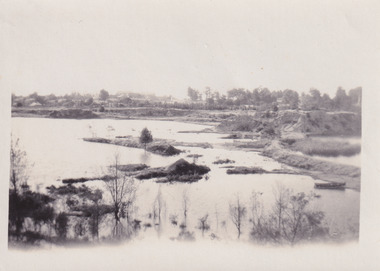
Photograph, c1960
... As well as improving swimming facilities, funds were raised to install a caravan park facility near the lake. ...As well as improving swimming facilities, funds were raised to install a caravan park facility near the lake. ...The photograph depicts a view across the water at Lake Sambell. The image is thought to date from the 1960s so may show the lake during a period of drought, such as that experienced across South-Eastern Australia in 1967. The present day park and reserve occupies the site of the former Rocky Mountain Mining Company, an open-cut sluice mine that began operations in the mid-Nineteenth Century and operated until the early 1900s, through the peak of Victoria’s Gold Rush. It was converted into a park and leisure area in the 1920s. Lake Sambell was formally opened to the public on Friday 5th October 1928 and was opened by the Victorian Government’s Minister of Lands, Mr Bailey, as part of initiatives to boost the economies and development of country towns. The lake was named after Mr L.H. Sambell, a shire engineer and secretary of the Forward Beechworth Committee who was involved in promoting the transformation of the mining site and promoting plantation forestry and tourism as alternative industries. £300 to begin the process was provided by Mr J. McConvill, a former resident of Beechworth, who is remembered in a street name adjacent to the lake. Residents of Beechworth have worked to raise funds to improve the Lake Sambell reserve several times, such as efforts in the 1930s and 1940s to raise the banks several feet to deepen the water for swimming purposes. Fundraising campaigns include the ‘Ugly Man’ competition conducted on behalf of the Wallace Park-Lake Sambell Development Scheme. The latter competition was run by the Fire Brigade Bend’s team as part of a larger competition called the ‘Mile of Pennies’; it was won by Mr Len Knight of Beechworth’s Commercial Hotel. The ‘Mile of Pennies’ was conducted at a Carnival held on New Year’s Eve, 1947. It was proposed by the Beechworth and District Progress Association. As well as improving swimming facilities, funds were raised to install a caravan park facility near the lake. Funds were also donated by commercial entities, such as £250 received from Zwar Bros. Pty Ltd.The photograph is significant as it shows Lake Sambell at lower water levels, such as may have been experienced during period of drought.Sepia rectangular photograph printed on matte photographic paperObverse: nil Reverse: 3470beechworth, beechworth lake, lake sambell, lake, beechworth and district progress association, forward beechworth committee, ugly man, mile of pennies, wallace park lake sambell development scheme, wallace park-lake sambell development scheme, zwar bros, zwar, l.h. sambell, j. mcconvill, minister of lands, commercial hotel, len knight, rocky mountain mining company, rocky mountain mining co, gold rush, redevelopment, transformation, community fundraising, drought, 1967, 1960s -
 The Beechworth Burke Museum
Photograph, 1960s
... Throughout the 1940s the Beechworth Swimming Club tried to raise awareness and funds to address the structural engineering issues and improve swimming facilities at the lake. R.E. Carter, similar to L.H. ...Throughout the 1940s the Beechworth Swimming Club tried to raise awareness and funds to address the structural engineering issues and improve swimming facilities at the lake. R.E. Carter, similar to L.H. ...This photo was taken in the 1960s from a northeast position looking down towards Lake Sambell, the caravan park, and the surrounding area. This photo was taken during a period of rejuvenation for the lake area including the opening of the caravan park in 1959 and the swimming pool area in 1961 (this pool is just visible in the centre of the photo). The popularity of caravanning in Australia exploded during this post-war period of the late 1950s and 1960’s. This popularity was driven by multiple factors, including: the stopping of fuel rations, the accessibility of car ownership through the manufacturing of affordable cars, technological developments in caravan design, and the increase in prosperity and leisure time for many Australians. Lake Sambell is an artificial lake that was developed on the previous site of the Rocky Mountain Mining Company workings and was officially opened by Minister for Lands, Mr Baily, on October 5, 1928. The disused and unattractive remains of the mine were converted into a recreational area intended for swimming, boating, and fishing. The lake is named after Mr L.H. Sambell, shire engineer and secretary of the Forward Beechworth Committee, who advocated for the enhancement of Beechworth into a tourist destination and was central to the planning and establishment of the lake. Funding for the project was raised by both competition funds and donations. Since the construction in 1928 several engineering issues have arisen. In 1939 the water levels were low, and the lake was considered both an eyesore and ‘mudhole’, Beechworth Shire Council sort funding to raise the height of the lake six feet to improve the quality of water. Throughout the 1940s the Beechworth Swimming Club tried to raise awareness and funds to address the structural engineering issues and improve swimming facilities at the lake. R.E. Carter, similar to L.H. Sambell, was a shire engineer who advocated the importance of positioning Beechworth as a tourist destination. Carter held the position from 1954-63 and organised many improvements to the Lake Sambell area including the caravan park in 1959, the lake swimming pool in 1961, water skiing and boating facilities, and increased the lake surface are in 1964. These improvements were financed mainly by grants from the Tourist Development Authority. This photograph is of historical significance as it documents Lake Sambell and the surrounding area in the 1960s after a phase of enhancements to improve the appearance and usability for both the people of Beechworth and tourists. It is also of social significance in providing an insight into the increase in leisure time and access to travel during a period of post-war prosperity.Black and white rectangle photograph printed on matte photographic paper and unmounted.Reverse: 1 / [logo KODAK/ VELOX/ PAPER] / C798 / 3535lake sambell, lake sambell caravan park, lake sambell swimming pool, caravan park, caravanning 1960s, rocky mountain mining company, l.h. sambell, r.e. carter, beechworth swimming club, forward beechworth committee, minister of lands, tourist development authority, lake swimming, swimming, boating, fishing, water skiing, beechworth 1960s, lake sambell fishing, lake sambell boating -
 Bendigo Military Museum
Postcard - PUCKPUNYAL ARMY BASE, Camera World, c.1980
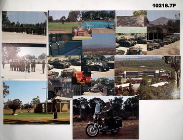
... Swimming Pools. 3. Puckapunyal Memorial. 4. Front entrance Tank Museum. 5. Tank Museum. 6. Instructional Block at Tobruk Barracks. 7. Suzuki Motorcycle used for convoy control. 1. Two colour photographs of soldiers in uniform on parade. 2. Collage of five photographs of facilities ...Part of the "Kevin John Herdman" (No. 397661) collection. See Cat No. 5942P for details of his service.1. Two colour photographs of soldiers in uniform on parade. 2. Collage of five photographs of facilities at Puckapunyal. 3. Colour photograph of a memorial building - Puckapunyal. 4. Collage of four colour photographs featuring vehicles and tanks. 5. Collage of five colour photographs featuring tanks. 6. Colour elevated photograph of a building. 7. Colour photograph of a soldier in uniform on a motorcycle.On back of each postcard. 1. March out parade. 2. Married quarters, Golf links, Assembly Hall, Swimming Pools. 3. Puckapunyal Memorial. 4. Front entrance Tank Museum. 5. Tank Museum. 6. Instructional Block at Tobruk Barracks. 7. Suzuki Motorcycle used for convoy control.kevin john herdman, postcards, puckapunyal -
 Kiewa Valley Historical Society
Book - Reference Cooking, Mount Beauty Souvenir Cookery Book x2, Circa 1962
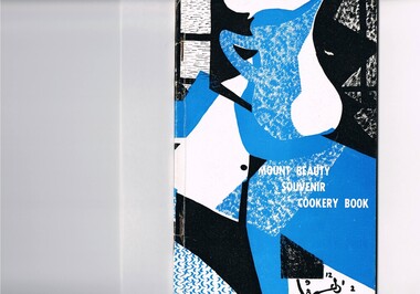
... swimming pool (which possible would have been provided had the SEC still been responsible). The book demonstrates the strong rural psyche of rallying together for the good of all and united for something which would be of benefit to all. The period 1961 to the 1970s was one of great change for Mount Beauty. The SEC protective cage was a blessing for some but a goal for others. The independence that was gained after the SEC left provided for a drastic "make over" in regards to the facilities ...This cookery book was printed in the early 1960s for the purpose of obtaining the necessary funds for the construction of the Mount Beauty swimming pool. The advertisements within this book covers local traders of this time frame, for example, the Bogong Hotel which is no longer operational. the culinary measurements are in Imperial measures(pounds and ounces). The book has sections for continental dishes and sweets (Australian flavour), special dishes for Lent, cakes (farmhouse fruit cake), jams, marmalades (home made), marrow and apple chutney. Some of these recipes are early 20th Century related and in the 2000s are not sought after. The food "take away" lifestyle has been responsible for the demise of a lot of the recipes in this book. The swing away from home grown produce has been not only a lifestyle change but also the faster pace of living in rural areas. The specialisation and redefined development of the local produce store (previously provided everything the rural shopper needed) was a forced move due to larger and cheaper city born fresh food supermarkets. Although there are still some local produce store within the region these will in time vanish. This cookery book was produced just after Mount Beauty was released from an SEC "closed" community in 1961(see KVHS 0134) and the town then had to fend for itself. This book was compiled and produced because the town needed a swimming pool (which possible would have been provided had the SEC still been responsible). The book demonstrates the strong rural psyche of rallying together for the good of all and united for something which would be of benefit to all. The period 1961 to the 1970s was one of great change for Mount Beauty. The SEC protective cage was a blessing for some but a goal for others. The independence that was gained after the SEC left provided for a drastic "make over" in regards to the facilities provided for the "locals" and that for the tourists. An increase in tourist related industries such as snow skiing in winter, hang gliding and gliding, mountain bike rallies, bush walking and horse riding, all of which have supply outlets in the town, has provided a more cosmopolitan atmosphere. These activities and the greater interaction with populations outside of the region has reduced the "hermit" type feel of the town psyche.This recipe book consists of eighty nine pages in black and white print. It contains black and white sketches, recipes of local domestic cooks and advertisements covering local traders. The cover is approximately 280 g/m2 in weight and the pages are at 90 g/m2 in weight. The cover has a design in the style of Abstract Expressionism (period 1950-1960s) of identifiable (clock,jug,fruit,window) and abstract objects in tints of blue and shades of black. This was designed by Cheryl Ryder of the Mount Beauty High School, under supervision of Mr I Baker (Art Teacher)On the foreword(page two and page three) "Mt. Beauty Souvenir Cookery Book First Edition" . This foreword was presented by Rosa Kinnear, President, Ladies' Auxiliary 2nd copy - no inscriptionrecipe, cooking, food, domestic, kitchen, local history, comfort food, pioneer cleaning methods -
Federation University Historical Collection
Book - Book - Scrapbook, Ballarat College of Advanced Education: Scrapbook of newspaper cutting, Book 5; March 1979 to August 1979
... facilities popular...chemical institute branch formed...great hall takes shape...educationalists in ballarat...another degree for frank hurley...dr mosley on barrier reef...posters depict conservation...bcae gets gift of logo...bcae's first annual council meeting...pilot fatigue significant factor...management training - business survey...better decision makers...industrial safety...engineering heritage display...why people take risks...vtu boycott suspended...prof david klein u.s.a....prof praises bcae course...swimming...The cuttings cover the period from 21 March 1979 to 4 August 1979. . employment advertisements application for enrolment outline of courses scholarships for bcae students western mining corporation gunther jahnks stephen fernee jim stringer robert withers former student earthquakes new men at bcae geoff westcott garry kinnane jeffrey leeuwenberg study of muscle power dr alan roberts mark heuston new at bcae cao duc thac - school of business bruce cossins - civil engineering val lloyd - librarianship department prof hilda elkins - librarianship department for 6 months community support vital to colleges inquiry committee in ballarat growing concern for sports injuries shortage of qualified metallurgists 400 graduate graeme jeffries engineering accountancy prize to belinda tantau john wach appointed to mt stromlo observatory energy seminar minister for minerals and energy teacher union may put ban on bcae bcae director replies bcae indoor sports facilities popular chemical institute branch formed great hall takes shape educationalists in ballarat another degree for frank hurley dr mosley on barrier reef posters depict conservation bcae gets gift of logo bcae's first annual council meeting pilot fatigue significant factor management training - business survey better decision makers industrial safety engineering heritage display why people take risks vtu boycott suspended prof david klein u.s.a. prof praises bcae course swimming instructors 2-day course david jelbart retires gunther jahnke wins arblaster award bcae library expands regional colleges Book with grey cover, front. ...Newspaper cuttings relating to Ballarat College of Advanced Education. These are from various newspapers and include The Age, Ballarat Courier, The Australian, The Herald. The cuttings cover the period from 21 March 1979 to 4 August 1979. . Book with grey cover, front. Spiral bound.employment advertisements, application for enrolment, outline of courses, scholarships for bcae students, western mining corporation, gunther jahnks, stephen fernee, jim stringer, robert withers former student, earthquakes, new men at bcae, geoff westcott, garry kinnane, jeffrey leeuwenberg, study of muscle power, dr alan roberts, mark heuston, new at bcae, cao duc thac - school of business, bruce cossins - civil engineering, val lloyd - librarianship department, prof hilda elkins - librarianship department for 6 months, community support vital to colleges, inquiry committee in ballarat, growing concern for sports injuries, shortage of qualified metallurgists, 400 graduate, graeme jeffries engineering, accountancy prize to belinda tantau, john wach appointed to mt stromlo observatory, energy seminar, minister for minerals and energy, teacher union may put ban on bcae, bcae director replies, bcae indoor sports facilities popular, chemical institute branch formed, great hall takes shape, educationalists in ballarat, another degree for frank hurley, dr mosley on barrier reef, posters depict conservation, bcae gets gift of logo, bcae's first annual council meeting, pilot fatigue significant factor, management training - business survey, better decision makers, industrial safety, engineering heritage display, why people take risks, vtu boycott suspended, prof david klein u.s.a., prof praises bcae course, swimming instructors 2-day course, david jelbart retires, gunther jahnke wins arblaster award, bcae library expands, regional colleges -
 The Beechworth Burke Museum
Photograph, 1960s
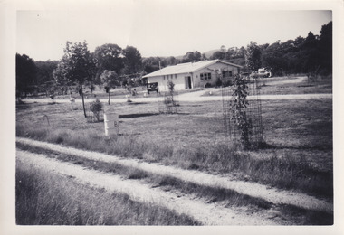
... The opening of the caravan park was part of many improvements to Lake Sambell made in this period by Carter including: the swimming pool in 1961, water skiing and boating facilities, and increased lake surface in 1964. ...The opening of the caravan park was part of many improvements to Lake Sambell made in this period by Carter including: the swimming pool in 1961, water skiing and boating facilities, and increased lake surface in 1964. ...This photograph was taken in the 1960s at Lake Sambell Caravan Park and visible in the photograph are individual caravan sites with electricity outlets, a large single-story building with a caravan park banner, dirt roads, a freestanding message board, and a parked car. Lake Sambell Caravan Park opened in 1959 owing to the work of R.E. Carter, Beechworth Shire engineer from 1954-63. Carter advocated for improvements to the lake and surrounding area in order to encourage tourism in Beechworth. The opening of the caravan park was part of many improvements to Lake Sambell made in this period by Carter including: the swimming pool in 1961, water skiing and boating facilities, and increased lake surface in 1964. These improvements were financed mainly by grants from the Tourist Development Authority. The popularity of caravanning in Australia exploded during this post-war period of the late 1950s and 1960s. This popularity was driven by multiple factors, including: the stopping of fuel rations, the accessibility of car ownership through the manufacturing of affordable cars, technological developments in caravan design, and the increase in prosperity and leisure time for many Australians. Facilities such as electrical outlets to power caravans are present in this photograph of Lake Sambell Caravan Park. Lake Sambell is an artificial lake that was developed on the previous site of the Rocky Mountain Mining Company workings and was officially opened by Minister for Lands, Mr Baily, on October 5, 1928. The disused and unattractive remains of the mine were converted into a recreational area intended for swimming, boating, and fishing. The lake is named after Mr L.H. Sambell, shire engineer and secretary of the Forward Beechworth Committee, who advocated for the enhancement of Beechworth into a tourist destination and was central to the planning and establishment of the lake. This photograph is of historical and social significance in providing insight into caravanning during the 1960s in Australia. Caravanning was extremely popular during the 1960s in Australia due to multiple social and economic factors including the stopping of fuel rations, the accessibility of car ownership through the manufacturing of affordable cars, technological developments in caravan design, and the increase in prosperity and leisure time for many Australians.Black and white rectangle photograph printed on photographic paper and unmounted.Reverse: 3536/ [logo back printing: KODAK/ VELOX/ PAPER] / C798 lake sambell caravan park, lake sambell, caravanning 1960s, caravan park, rocky mountain mining company, kodak velox paper, r.e. carter, l.h. sambell, caravan electricity outlets, tourist development authority, post-war prosperity, forward beechworth committee, lake sambell boating, lake sambell swimming pool, lake sambell fishing, artificial lake, travel 1960s, recreation 1960s -
 The Beechworth Burke Museum
Photograph, 1960s
... The opening of the caravan park was part of many improvements to Lake Sambell made in this period by Carter including: the swimming pool in 1961, water skiing and boating facilities, and increased lake surface in 1964. ...The opening of the caravan park was part of many improvements to Lake Sambell made in this period by Carter including: the swimming pool in 1961, water skiing and boating facilities, and increased lake surface in 1964. ...This photograph was taken in the 1960s at Lake Sambell Caravan Park, visible in the photograph are individual caravan sites with electricity outlets, a large single-story building, a parked car, and two caravans partially obstructed by trees. Lake Sambell Caravan Park opened in 1959 owing to the work of R.E. Carter, Beechworth Shire engineer from 1954-63. Carter advocated for improvements to the lake and surrounding area in order to encourage tourism in Beechworth. The opening of the caravan park was part of many improvements to Lake Sambell made in this period by Carter including: the swimming pool in 1961, water skiing and boating facilities, and increased lake surface in 1964. These improvements were financed mainly by grants from the Tourist Development Authority. The popularity of caravanning in Australia exploded during this post-war period of the late 1950s and 1960s. This popularity was driven by multiple factors, including: the stopping of fuel rations, the accessibility of car ownership through the manufacturing of affordable cars, technological developments in caravan design, and the increase in prosperity and leisure time for many Australians. Facilities such as electrical outlets to power caravans are present in this photograph of Lake Sambell Caravan Park. Lake Sambell is an artificial lake that was developed on the previous site of the Rocky Mountain Mining Company workings and was officially opened by Minister for Lands, Mr Baily, on October 5, 1928. The disused and unattractive remains of the mine were converted into a recreational area intended for swimming, boating, and fishing. The lake is named after Mr L.H. Sambell, shire engineer and secretary of the Forward Beechworth Committee, who advocated for the enhancement of Beechworth into a tourist destination and was central to the planning and establishment of the lake. This photograph is of historic and social significance in documenting the enhancement of the Lake Sambell area overseen by R.E. Carter and providing insight into caravanning during the 1960s in Australia. Caravanning was extremely popular in Australia during the late 1950s and 60s due to multiple social and economic factors including the stopping of fuel rations, the accessibility of car ownership through the manufacturing of affordable cars, technological developments in caravan design, and the increase in prosperity and leisure time for many Australians. Black and white rectangle photograph printed on photographic paper and unmounted.Reverse: 3538/ [logo back printing KODAK/ VELOX/ PAPER] / C798lake sambell caravan park, lake sambell, lake sambell 1960s, lake sambell fishing, lake sambell boating, lake sambell swimming pool, r.e. carter, l.h. sambell, tourist development authority, caravanning 1960s, caravan electricity outlets, caravan park, forward beechworth committee, rocky mountain mining company, lake caravan park, caravan mid 20th century, beechworth tourism, travel in the 1960s, holiday 1960s -
 Bendigo Historical Society Inc.
Medal - VAL CAMPBELL COLLECTION:AUSTRALIAN SPORTS MEDAL AND MINIATURE, 2000
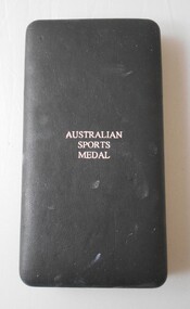
... The medal has been reinstated for awards in 2020.The medal recognizes the efforts of a range of Australians, including former competitors, coaches, sports scientists, office holders and those who maintained sporting facilities and services. RECREATIONS Sports Swimming Australian Sports Medal and miniature and presentation box awarded to Val Campbell in 2000. ...The Australian Sports Medal award was instituted in the year 2000 and awarded for 2000 and 2001 before being discontinued. The medal has been reinstated for awards in 2020.The medal recognizes the efforts of a range of Australians, including former competitors, coaches, sports scientists, office holders and those who maintained sporting facilities and services.Australian Sports Medal and miniature and presentation box awarded to Val Campbell in 2000. The medal is a round shape of silver coloured metal suspended from a yellow ribbon with four green stripes. The design on the obverse is the five stars of the Southern Cross constellation above four horizontal lines. On the reverse are the same four horizontal lines as the obverse with the engraved words To commemorate Australian sporting achievement forming a half circle around the top edge and the words Valma Marion Campbell engraved above the four horizontal lines.The year 2000 is engraved below the four horizontal lines. A clasp to affix the medal to clothing is attached on the back of the ribbon. The miniature is a replica of the medal itself and is identical in every respect except for the engraved name on the reverse. The presentation box is encased in black leather like fabric and is padded on the lid with the words Australian Sports Medal stamped in silver. The box is line with white satin on the inside of the hinged lid with the medals resting in a moulded black velvet covered tray. Certificate accompanying the Australian Sports Medal and miniature and presentation box awarded to Val Campbell in 2000. 'To Valma Marion Campbell' See 11209.107recreations, sports, swimming -
Port Melbourne Historical & Preservation Society
Plan - Swimming Baths, Port Melbourne, Plan of Proposed Baths, 1909
... Facilities...Sport - Swimming...Built Environment - Recreational Facilities Sport - Swimming Arthur Victor HEATH Town Clerks Corporation Swimming Baths Plan of proposed swimming baths at Port Melbourne, 1909 (unsigned) Plan of Proposed Baths Plan Swimming Baths, Port Melbourne ...Originally held at Port Melbourne Town Hall. Intended for area between Town Pier and Lagoon. Plans drawn in March 1909 (see no. 452 pp 287and 416), but never implemented.Plan of proposed swimming baths at Port Melbourne, 1909 (unsigned)Corporation Swimming Bathsbuilt environment - recreational facilities, sport - swimming, arthur victor heath, town clerks -
Port Melbourne Historical & Preservation Society
Plan - Bathing Dressing Shelter, Port Melbourne, Engineering Department, City of Port Melbourne, 22 Sep 1911
... Facilities...Sport - Swimming...Port Melbourne Historical & Preservation Society Port Melbourne Town Hall 333 Bay Street Port Melbourne melbourne Built Environment - Recreational Facilities Sport - Swimming Arthur Victor HEATH Town Clerks Joseph FISHER Signed by Joseph Fisher 22-9-1911 and A. ...Plan for simple dressing shelter for bathing, 1911.Signed by Joseph Fisher 22-9-1911 and A. V. Heath 28-9-1911built environment - recreational facilities, sport - swimming, arthur victor heath, town clerks, joseph fisher -
 Bendigo Historical Society Inc.
Booklet - Official Opening of the Greater Bendigo Indoor Swimming Complex
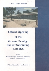
... Swimming Complex at Eaglehawk. Opened by the Minister for Sport, Recreation and Racing, the Hon. Tom Reynolds M.P. 2.30 pm Wednesday 14th December. Year not given but is in the 1990s Coloured photo of complex on front gage and page 3. Description of facilities...Swimming Complex at Eaglehawk. Opened by the Minister for Sport, Recreation and Racing, the Hon. Tom Reynolds M.P. 2.30 pm Wednesday 14th December. Year not given but is in the 1990s Coloured photo of complex on front gage and page 3. Description of facilities ...4-page booklet (A4 size paper folded in half). Official Opening of the City of Greater Bendigo Indoor Swimming Complex at Eaglehawk. Opened by the Minister for Sport, Recreation and Racing, the Hon. Tom Reynolds M.P. 2.30 pm Wednesday 14th December. Year not given but is in the 1990s Coloured photo of complex on front gage and page 3. Description of facilities, development, programmes and activities. eaglehawk swimming complex, peter krenz -
Port Melbourne Historical & Preservation Society
Book, "Seabaths of Victoria" by Bruce Bennett, 2013
... facilities...sport - swimming...Port Melbourne Historical & Preservation Society Port Melbourne Town Hall 333 Bay Street Port Melbourne melbourne built environment - recreational facilities sport - swimming bruce bennett sea baths "Seabaths of Victoria" by Bruce Bennett. ..."Seabaths of Victoria" by Bruce Bennett. Bound illustrated book with front cover painting of Seabaths at Sorrento. Chapter IV is about the Sandridge area. Also includes chapters on St Kilda and South Melbournebuilt environment - recreational facilities, sport - swimming, bruce bennett, sea baths -
 Ringwood and District Historical Society
Souvenir, Complimentary A.W.Dickson Real Estate Agents calendars - 1987 and 1988.1987 calendar with photographic images of local Ringwood features and 1988 calendar featuring local Ringwood land sale promotional images from early 20th Century
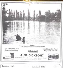
... swimming facility opened in 1986 at a cost of $3 million. Featuring the latest ozone water treatment techniques. In summer folding doors can be opened to give access to existing outdoor pools and sunbathing area. (July August 1987) MAROONDAH HOSPITAL - Opened in 1976 after many years of fund raising efforts by local people. The opening of casualty facilities...swimming facility opened in 1986 at a cost of $3 million. Featuring the latest ozone water treatment techniques. In summer folding doors can be opened to give access to existing outdoor pools and sunbathing area. (July August 1987) MAROONDAH HOSPITAL - Opened in 1976 after many years of fund raising efforts by local people. The opening of casualty facilities ...A.W.Dickson was a Real Estate Agent in Ringwood for many years. These calendars show the local buildings of the day. For example the original Eastland 's building of 1967, Maroondah Hospital 1976 and the Civic Centre now the Karralyka Centre.1 1987 calendar with six black and white photos of buildings and vistas around Ringwood with monthly dates in lower quarter of page. 2 1988 calendar with six posters advertising early 20th century land sales in Ringwood, Heathmont and Ringwood East with dates in lower quarter of page Compiled by A.W.Dickson Pty. Ltd. Real Estate Agent. Photographed by C.M.S. Photographers - 725 9441 (January February 1987) RINGWOOD LAKE - Ideal picnic spot for Ringwood Model power boats frequently on display. Barbecue area, playground, resting place for old steam engine. Yabbie netting is a favourite pastime here. (March April 1987) CLOCK TOWER - Moved from its former site on Warrandyte Road corner in 1967 and re-built in its present location, brick by brick. A wreath laying ceremony is held here on Anzac day each year. (May June 1987) RINGWOOD AQUATIC CENTRE - A world class swimming facility opened in 1986 at a cost of $3 million. Featuring the latest ozone water treatment techniques. In summer folding doors can be opened to give access to existing outdoor pools and sunbathing area. (July August 1987) MAROONDAH HOSPITAL - Opened in 1976 after many years of fund raising efforts by local people. The opening of casualty facilities was welcomed by locals as previously Box Hill Hospital catered for the entre area. (September October 1987) EASTLAND - Opened October 1967. Built on a former football oval. Now about to undergo major extensions to cater for Ringwood's population growth into the 21st Century. November December 1987 CIVIC CENTRE - Built on the site of a former antimony mine behind the council offices. Now the venue for many activities and a local point for Ringwood's Cultural Life. -
 Ringwood and District Historical Society
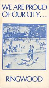
Pamphlet, We Are Proud of Our City - Ringwood (1973), 1973
... Swimming Centre, Jubilee Park." "The staff at the Civic Centre are at your service. Ring 8704311 for guidance on - Town Planning applications, Road and footpath construction, Building matters, Garbage clearance, Connection to sewer by end of 1973, Immunisation times and places, Home help, Rate payments and valuations, Booking of meeting rooms, Clearance of fire hazards, Stray dogs and all nuisance complaints." Community information brochure issued in 1973 by Ringwood Council outlining local services, sporting, and cultural facilities ...Community information brochure issued in 1973 by Ringwood Council outlining local services, sporting, and cultural facilities. Includes names of Ward Councillors, and two City of Ringwood Free Tipping Vouchers valid until the end of 1974."Frontpiece: A quiet corner of the Fred Dwerryhouse Swimming Centre, Jubilee Park." "The staff at the Civic Centre are at your service. Ring 8704311 for guidance on - Town Planning applications, Road and footpath construction, Building matters, Garbage clearance, Connection to sewer by end of 1973, Immunisation times and places, Home help, Rate payments and valuations, Booking of meeting rooms, Clearance of fire hazards, Stray dogs and all nuisance complaints."rinx -
 Ringwood and District Historical Society
Booklet, Champion Press, City of Ringwood Report to Ratepayers 1981, 1981
... Corr 4 Meals on Wheels 28 Members of Parliament 50 Officers of the Council 9 Proposed Leisure Centre 14 Rate Assistance 11 Rate Payments 10 Recycling Depots 49 Ringwood Cultural Centre 2 Ringwood Festival activities for 1981 29 Standing Committees of Council 5 Swimming Centre 13 Welfare and Community Services 34 Community booklet issued by City of Ringwood for 1981 - covering the facilities and activities of the Ringwood Council and other local organisations and associations. ...Community booklet issued by City of Ringwood for 1981 - covering the facilities and activities of the Ringwood Council and other local organisations and associations. CONTENTS: (page number) Beautification and Leisure Areas 24 Building — General Information 21 Commissioners for Taking Declarations and Affidavits 15 Council Finance 11 Council Meeting Dates 5 Council Representation on various organisations 8 Councillors 6 Elections for Council 10 Emergency Telephone Numbers 51 Health -30 Home Help Service 22 Immunisation Programme 31 Infant Welfare Centres 33 Items of Interest 16 Justices of the Peace 14 Let's Be Neighbourly 20 Library — General 18 Library — Service for our Senior Citizens 23 Major Works 12 Map of municipality 26 Mayor's Message - Cr. F.J. Corr 4 Meals on Wheels 28 Members of Parliament 50 Officers of the Council 9 Proposed Leisure Centre 14 Rate Assistance 11 Rate Payments 10 Recycling Depots 49 Ringwood Cultural Centre 2 Ringwood Festival activities for 1981 29 Standing Committees of Council 5 Swimming Centre 13 Welfare and Community Services 34 rinx -
 Ringwood and District Historical Society
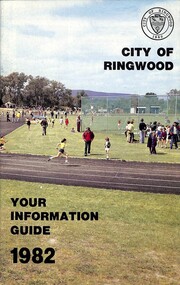
Booklet, City of Ringwood - Your Information Guide 1982, 1982
... Beautification and Leisure Areas 16 Building — General Information 26 By-Laws 27 Circuit Bus — Ringwood City 54 Commissioners for taking Declarations and Affidavits 31 Council Meeting Dates 6 Council Representation 7 Councillors 4 Cultural Centre 32 Disabled Persons - Facilities 34 Elections for Council 10 Emergency Telephone Numbers 54 Festival 33 Finance — Council 12 Golf Course 30 Health Home Help Service 24 Immunisation Programme 20 Items of Interest 22 Justices of the Peace 30 Library — General 13 Library — Service for our Senior Citizens 26 Major Works Programme 14 Map of Municipality 28 Mayor's Message – Cr. N.J. Hamilton 2 Meals on Wheels 25 Members of Parliament 52 Officers of the Council 8 Property Records 10 Rates 11 Recycling Depots S3 Regulations 27 Roll — Municipal 10 Swimming...Beautification and Leisure Areas 16 Building — General Information 26 By-Laws 27 Circuit Bus — Ringwood City 54 Commissioners for taking Declarations and Affidavits 31 Council Meeting Dates 6 Council Representation 7 Councillors 4 Cultural Centre 32 Disabled Persons - Facilities 34 Elections for Council 10 Emergency Telephone Numbers 54 Festival 33 Finance — Council 12 Golf Course 30 Health Home Help Service 24 Immunisation Programme 20 Items of Interest 22 Justices of the Peace 30 Library — General 13 Library — Service for our Senior Citizens 26 Major Works Programme 14 Map of Municipality 28 Mayor's Message – Cr. N.J. Hamilton 2 Meals on Wheels 25 Members of Parliament 52 Officers of the Council 8 Property Records 10 Rates 11 Recycling Depots S3 Regulations 27 Roll — Municipal 10 Swimming ...Community information booklet issued by City of Ringwood for 1982 - covering the facilities and activities of the Ringwood Council and other local organisations and associations. Cover photograph: A.C. Robertson Athletic Field. CONTENTS: (page no.) Beautification and Leisure Areas 16 Building — General Information 26 By-Laws 27 Circuit Bus — Ringwood City 54 Commissioners for taking Declarations and Affidavits 31 Council Meeting Dates 6 Council Representation 7 Councillors 4 Cultural Centre 32 Disabled Persons - Facilities 34 Elections for Council 10 Emergency Telephone Numbers 54 Festival 33 Finance — Council 12 Golf Course 30 Health Home Help Service 24 Immunisation Programme 20 Items of Interest 22 Justices of the Peace 30 Library — General 13 Library — Service for our Senior Citizens 26 Major Works Programme 14 Map of Municipality 28 Mayor's Message – Cr. N.J. Hamilton 2 Meals on Wheels 25 Members of Parliament 52 Officers of the Council 8 Property Records 10 Rates 11 Recycling Depots S3 Regulations 27 Roll — Municipal 10 Swimming Centre 21 Voting — Compulsory 10 Welfare and Community Services 35 rinx -
 Ringwood and District Historical Society
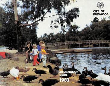
Booklet, City of Ringwood Information Guide 1983, 1983
... Pat Gotlib, J.P. 2 Meals on Wheels 24 Members of Parliament 56 Nature Strip Maintenance 34 Pensioners — Rate Assistance 11 Rates 10 Recycling of Waste 57 Roll — Municipal 10 Shuttle Bus 33 Swimming Centre 37 Voting — Compulsory 10 Welfare and Community Services 38 Community information booklet issued by City of Ringwood for 1983 - covering the facilities and activities of the Ringwood Council and other local organisations and associations. ...Community information booklet issued by City of Ringwood for 1983 - covering the facilities and activities of the Ringwood Council and other local organisations and associations. Cover photograph: Ringwood Lake Reserve.CONTENTS: (page no.) Aged — Centre for the Frail Aged 22 Building — General Information 28 By-Laws and Regulations 27 Circuit Bus — Ringwood City 33 Commissioners for taking Declarations and Affidavits 29 Committees of Council 6 Council Meeting Dates 6 Council Officers 8 Council Representation 7 Councillors 4 Cultural Centre 36 Disabled Persons - Facilities 21 Emergency Telephone Numbers 58 Elections for Council 10 Festival 23 Finance - Council 11 Garbage Collection 58 Golf Course 37 Health 18 Home Help 25 Immunisation Programme 20 Immunisation Schedule 19 Items of Interest 32 Justices of the Peace 29 Lake — Ringwood Lake Reserve 59 Leisure Areas 16 Library — General 12 Library - Service for our Senior Citizens 26 Major Works Programme 14 Map of Municipality 30 Mayor’s Message – Cr. Pat Gotlib, J.P. 2 Meals on Wheels 24 Members of Parliament 56 Nature Strip Maintenance 34 Pensioners — Rate Assistance 11 Rates 10 Recycling of Waste 57 Roll — Municipal 10 Shuttle Bus 33 Swimming Centre 37 Voting — Compulsory 10 Welfare and Community Services 38 rinx