Showing 10 items matching "sydney flat creek"
-
 Bendigo Historical Society Inc.
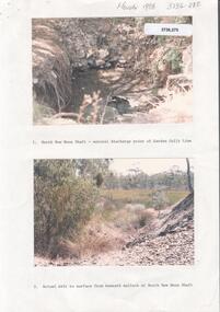
Photograph - Kangaroo Flat Gold Mine Collection: Deadhorse Gully, Sydney Flat Creek March 1986
... Kangaroo Flat Gold Mine Collection: Deadhorse Gully, Sydney Flat Creek March 1986......Sydney Flat Creek...Lined paper, in blue pen 'Deadhorse Gully-Sydney Flat Creek, March 1986, Photos of Deadhorse Gully/Sydney Flat Creek'...History House 11 Mackenzie Street Bendigo goldfields Kangaroo Flat Gold Mine Deadhorse Gully Sydney Flat Creek Unity Mining water discharge North New Moon Camp Road Pyramid Hill Road Eaglehawk Lined paper, in blue pen 'Deadhorse Gully-Sydney Flat Creek, March 1986, Photos of Deadhorse Gully/Sydney Flat Creek' Colour photographs, seventeen images on nine page. ...Colour photographs, seventeen images on nine page. Images labelled as follows : 1. North New Moon shaft - natural discharge point of Garden Gullly line 2. Actual exit to surface from beneath mullock at North New Moon shaft. 3. Looking into Deadhorse Gully from mullock heap at North New Moon site. 4. Deadhorse Gully downstream of WMC Weir. 5. Sydney Creek track crossing - impassable ford. 6. Sydney Creek looking downstream from ford. 7. Sydney Creek looking upstream from road near Recreation Reserve (12 inch pipe under road). 8. Sydney Creek looking downstream from same point. 9. Sydney Creek - Camp Road, looking upstream.. 10. Sydney Creek - Camp Road, looking downstream. 11. Sydney Creek - Camp Road Culverts. 12. Sydney Creek - Pyramid Road Bridge, looking upstream. 13. Sydney Creek - Pyramid Road Crossing looking downsteam. 14. Sydney Creek - rail crossing, looking upstream. 15. Sydney Creek - rail crossing, looking downstream. 16. Sydney Creek - Airstrip road, looking upstream. 17. Sydney Creek - Airstrip Road, looking downstream 12 inch pipe under road. Lined paper, in blue pen 'Deadhorse Gully-Sydney Flat Creek, March 1986, Photos of Deadhorse Gully/Sydney Flat Creek'kangaroo flat gold mine, deadhorse gully, sydney flat creek, unity mining, water discharge, north new moon, camp road, pyramid hill road, eaglehawk -
 Bendigo Historical Society Inc.
Book - SYDNEY FLAT GOLD TO WOODVALE GREEN, 1984
... Sydney Flat...Weddikar Run...Myers Creek...History House 11 Mackenzie Street Bendigo goldfields HISTORY woodvale Ray Wallace Woodvale Progress Association Sydney Flat Weddikar Run Myers Creek Eaglehawk poet book collector naturalist history 1845 gold 1852 squatters government early settlers farmed school church industry pubs railway sport artists Ray Wallace Sydney Flat Gold to Woodvale Green. ...Sydney Flat Gold to Woodvale Green. Espress Printers, Bendigo. ISBN L0-9591143-0-0. Cover Design & illustrations by Kevin Vallence. Woodvale Progress Association 1984. Photographs and Illustrations and plan. 80 pages. With IndexRay Wallacehistory, woodvale, ray wallace, woodvale progress association, sydney flat, weddikar run, myers creek, eaglehawk, poet, book collector, naturalist, history 1845, gold 1852, squatters, government, early settlers, farmed, school, church, industry, pubs, railway, sport, artists -
 Bendigo Historical Society Inc.
Document - Bendigo Creek name
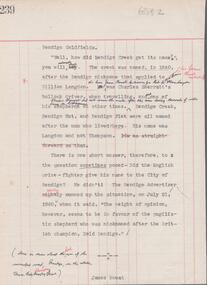
... Sydney to the now Heathcote region, then worked with his father at Yarraberb, where he had taken up a run. Mouat Origin of Bendigo name Charles Hutton Yarraberb One page typed document on lined ledger paper, with page number 239 on top left hand corner. Title: 'Bendigo Goldfields' a typed copy of a statement by James Mouat regarding the naming of Bendigo Creek and Bendigo. No date on document. Mouat claims that Bendigo Creek, Bendigo Flat ...James Mouat (born Glasgow April 23rd. 1823, died 12th June, 1893) came to Melbourne (then called Beargrass) in 1836. He firstly worked with Charles Hutton, who overlanded with sheep from Sydney to the now Heathcote region, then worked with his father at Yarraberb, where he had taken up a run. One page typed document on lined ledger paper, with page number 239 on top left hand corner. Title: 'Bendigo Goldfields' a typed copy of a statement by James Mouat regarding the naming of Bendigo Creek and Bendigo. No date on document. Mouat claims that Bendigo Creek, Bendigo Flat and Bendigo Hut were named after a Mr. Langdon (Jack) , not Thompson. mouat, origin of bendigo name, charles hutton, yarraberb, -
 Bendigo Historical Society Inc.
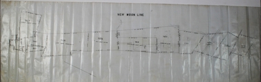
Plan - New Moon Group of Mines
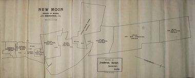
... The new Moon Group of mines were located in Sailors Gully/Sydney Flat Sydney Flat was originally regard as part of Myers Creek, later Myers Flat it was changed to Sydney Flat when mining was established and was changed to Woodvale in the 1920s Sydney Flat Bushland Reserve is near-by. ...History House 11 Mackenzie Street Bendigo goldfields The new Moon Group of mines were located in Sailors Gully/Sydney Flat Sydney Flat was originally regard as part of Myers Creek, later Myers Flat it was changed to Sydney Flat when mining was established and was changed to Woodvale in the 1920s Sydney Flat Bushland Reserve is near-by. ...The new Moon Group of mines were located in Sailors Gully/Sydney Flat Sydney Flat was originally regard as part of Myers Creek, later Myers Flat it was changed to Sydney Flat when mining was established and was changed to Woodvale in the 1920s Sydney Flat Bushland Reserve is near-by. The area is north of Sailors Gully.Draftsman's drawing on cream coloured paper of the New Moon group of mines scale 8 chains to 1 inch with the boundaries of each mine's claim. Inside each boundary is printed: the position of the shaft, Name Yards and the number of shares. The names are Specimen Hill, New Aguas, Clarence, North Argus, South New Moon, New Moon, Suffolk Tribute United, North New Moon, New Moon Consolidated, New Moon United. Printed in the lower centre - ISSUED BY Frederick Barker, Sharebroker, Bendigo J. B. Young, Lith, Bendigo.bendigo, gold, map, mine, margaret roberts collection, new moon mines, sailors gully, sydney flat -
 Bendigo Historical Society Inc.
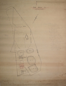
Plan - New Moon Co
... Sydney Flat. Sydney Flat was originally regard as part of Myers Creek, later Myers Flat it was changed to Sydney Flat when mining was established and was changed to Woodvale in the 1920s. ...Sydney Flat. Sydney Flat was originally regard as part of Myers Creek, later Myers Flat it was changed to Sydney Flat when mining was established and was changed to Woodvale in the 1920s. .... The new Moon Group of mines were located in Sailors Gully/Sydney Flat. Sydney Flat was originally regard as part of Myers Creek, later Myers Flat it was changed to Sydney Flat when mining was established and was changed to Woodvale in the 1920s. Sydney Flat Bushland Reserve is near-by. The area is north of Sailors Gully. Draftsman's drawing in black ink on off-white paper. Details of the New Moon lease with the boundary of the lease, four dams, Battery, Firewood Area, Shaft and Managers House. On the right of the drawing there is a hand- written detailed description of the site. Forms part of the Margaret Roberts Collection bendigo, margaret roberts, gold, map, mine, j. j. caldwell -
 Coal Creek Community Park & Museum
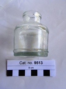
Bottle, glass, c. 1940
... Creek Community Park & Museum 12 Silkstone Road Korumburra gippsland The Advocate (Melbourne, Vic. : 1868 - 1954) Thursday 12 January 1939 p 31 Advertising ANGUS & CO PTY LTD MANUFACTURERS OF CLAG THE BEST HOME AND OFFICE PASTE AND WRITING INKS SHOWCARD COLOURS INDIAN INKS RUBBER STAMP PAD INKS MUCILAGE, GUMS, ETC. ANGUS & CO. PTY. LTD. MELBOURNE AND SYDNEY. ink bottle '154', 'ANGUS & CO PTY LTD', '3M'. Monogram 'A' with flat ...The Advocate (Melbourne, Vic. : 1868 - 1954) Thursday 12 January 1939 p 31 Advertising ANGUS & CO PTY LTD MANUFACTURERS OF CLAG THE BEST HOME AND OFFICE PASTE AND WRITING INKS SHOWCARD COLOURS INDIAN INKS RUBBER STAMP PAD INKS MUCILAGE, GUMS, ETC. ANGUS & CO. PTY. LTD. MELBOURNE AND SYDNEY. Round thick clear glass ink bottle with text and monogram embossed on base.'154', 'ANGUS & CO PTY LTD', '3M'. Monogram 'A' with flat top enclosing 'G' over 'M'.ink bottle -
 Whitehorse Historical Society Inc.
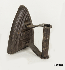
Functional object - Flat Iron
... Whitehorse Historical Society Inc. 2-10 Deep Creek Road Mitcham melbourne Belong to donors Aunt. More recently used as a door stop (40 Years). DOMESTIC ITEMS Irons Metters Sydney No 4 flat iron - black. ...Belong to donors Aunt. More recently used as a door stop (40 Years).No 4 flat iron - black.Metters Sydneydomestic items, irons -
 Ballarat Heritage Services
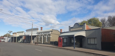
Photograph, Main Street of Talbot, Victoria, 2025, 07/2025
... Sydney, fearing trouble after his unauthorised sale of the gold that, according to the law of the time, was illegal. The first major rush in the area around current day Talbot occurred in December 1852 when gold was found in Daisy Hill, near what is now Amherst Cemetery (2km west of Talbot). News quickly spread and within a few weeks hundreds of miners from the nearby Castlemaine goldfields had arrived to try their luck. The next major gold find was in 1854 at Kangaroo Flat along Back Creek...Sydney, fearing trouble after his unauthorised sale of the gold that, according to the law of the time, was illegal. The first major rush in the area around current day Talbot occurred in December 1852 when gold was found in Daisy Hill, near what is now Amherst Cemetery (2km west of Talbot). News quickly spread and within a few weeks hundreds of miners from the nearby Castlemaine goldfields had arrived to try their luck. The next major gold find was in 1854 at Kangaroo Flat along Back Creek ...Throughout the 1840s there had been rumours of gold found in the area, but the evidence was suppressed. The authorities sought to keep the region as a quiet pastoral district, and feared that a gold rush could spark chaos and lawlessness among the largely convict population. In January 1849, former convict Thomas Chapman found a 38 ounce gold nugget in Daisy Hill Creek (7 km from Talbot) while working as a shepherd. He sold it to Melbourne jeweller Charles Brentani in early 1849. This was the first confirmed finding of gold in Victoria and kicked off a minor rush to the region. By late February 1849 thirty to forty trespassers were reported to have gathered at Thomas's former hut seeking gold before being disbanded by a party of police sent from Melbourne. Meanwhile, Thomas fled to Sydney, fearing trouble after his unauthorised sale of the gold that, according to the law of the time, was illegal. The first major rush in the area around current day Talbot occurred in December 1852 when gold was found in Daisy Hill, near what is now Amherst Cemetery (2km west of Talbot). News quickly spread and within a few weeks hundreds of miners from the nearby Castlemaine goldfields had arrived to try their luck. The next major gold find was in 1854 at Kangaroo Flat along Back Creek (1km out of Talbot). By November 1855 it was reported around 6,000 miners had taken up residence in what became known as Back Creek. But, as the gold dwindled, so too did the population and by end-1857 only a few houses remained. In 1859, a group of miners from Norway and Sweden led by Carl Hallen decided to look in an area just outside of Back Creek, previously thought barren of gold as it was un-forested. Their gamble was rewarded, and as the news spread, miners once again flooded into the area. Within 4 months of the Hallan Party's first shaft being dug, there were 50,000 people in the Back Creek region. To cater for this influx, streets were improvised in the area of the diggings - starting with what became known as "Scandinavian Crescent" along the edge of the actual diggings themselves. It remains to this day and is now the main street of Talbot. (https://www.melbourneplaygrounds.com.au/talbot-heritage-walk accessed 19 July 2025)Colour photograph of shops on Scandinavian Cresent, the Main road of Talbot, Victoriatalbot, back creek, gold mining -
 Bendigo Historical Society Inc.
Plan - New Moon Line of Reef
... Sydney Flat. Sydney Flat was originally regard as part of Myers Creek, later Myers Flat it was changed to Sydney Flat when mining was established and was changed to Woodvale in the 1920s. ...Sydney Flat. Sydney Flat was originally regard as part of Myers Creek, later Myers Flat it was changed to Sydney Flat when mining was established and was changed to Woodvale in the 1920s. ...The new Moon Group of mines were located in Sailors Gully/Sydney Flat. Sydney Flat was originally regard as part of Myers Creek, later Myers Flat it was changed to Sydney Flat when mining was established and was changed to Woodvale in the 1920s. Sydney Flat Bushland Reserve is near-by. The area is north of Sailors Gully.Draftsman's drawing on white coloured waxed paper of the New Moon Line with the boundaries of each mine's claim with a direction bearing and a number (chains) Inside each boundary is printed: the position of the shaft, Name and a number. The names and are; Suffolk Tribute United, North New Moon, New Moon Consolidated, New Moon United, Adelaide New Moon, IDavies & ors, F. Day, P. Booth, D. Murdoch, J. Mani. bendigo, gold, map, mine, margaret roberts collection, new moon mines, sailors gully, sydney flat -
 Bendigo Historical Society Inc.
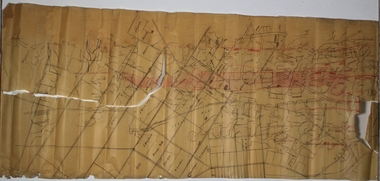
Plan - Parish Map of Sydney Flat
... The New Moon Group of mines were located in the Sailors Gully/ Sydney Flat area. Sydney Flat was originally regard as part of Myers Creek, later Myers Flat it was changed to Sydney Flat when mining was established and was changed to Woodvale in the 1920s Sydney Flat Bushland Reserve is near-by. ...The New Moon Group of mines were located in the Sailors Gully/ Sydney Flat area. Sydney Flat was originally regard as part of Myers Creek, later Myers Flat it was changed to Sydney Flat when mining was established and was changed to Woodvale in the 1920s Sydney Flat Bushland Reserve is near-by. ...The New Moon Group of mines were located in the Sailors Gully/ Sydney Flat area. Sydney Flat was originally regard as part of Myers Creek, later Myers Flat it was changed to Sydney Flat when mining was established and was changed to Woodvale in the 1920s Sydney Flat Bushland Reserve is near-by. The area is north of Sailors Gully.Draftsman's drawing on cream coloured waxed paper with black print. SYDNEY FLAT is printed in the centre of a grid of streets with no names divided into sections there are names many of the sections including - J Dolman, G Wills, Gill, J Bayliss, Fracis Webb, T Downie, H Turner, J Hodgson, J Gordon, W Booth, J Shadbolt, J S Pearson, C Maroney, I Quin & Co, W Davey, J Kelly. Printed out of the grid is New Moon U and New Moon Cons. Added red handwriting are reef lines including - Christmas, Thistle, Carshalton, Napoleon, Gr nite, New Chum , Moon, Gully, Derby, Hustlers. There is red shading on Gully, Moon and New Chum lines.bendigo, gold, map, mine, margaret roberts collection, new moon mines, sailors gully, sydney flat