Showing 20 items matching "t.f. mcgauran"
-
 Stawell Historical Society Inc
Map, T.F. McGauran, William Couty of Borong 1891, 1891
... Photo Lithographed at the Department of Lands and Survey Melbourne. By T.F. McGauran 20.07.91 ...T.F. McGauran...Marked in red William Couty of Borong 1891 Map T.F. McGauran ...Stawell Water Supply Reserve. Grampians State Forest. Dairy Creek, Fyans Creek, Barney's Creek, Bovine Creek, Glasstree Creek, Stoney Creek. Stawell Water Supply Aquaduct Fkuming Tunnel.A2 Parish Map of Willam Inculdin Stawell Water Supply Reserve and Creeks. Marked in redPhoto Lithographed at the Department of Lands and Survey Melbourne. By T.F. McGauran 20.07.91 water supply survey -
 Federation University Historical Collection
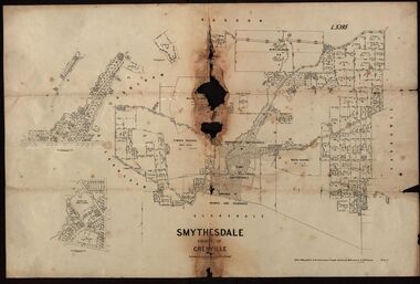
Plan, Smythesdale, County of Grenville, 01/12/1892
... ...T.F. McGauran......T.F. McGauran...Gift of the Squire Family smythesdale scarsdale browns yarrowee carngham samuel barlett sheridan wrigley p. land r. simpson d. davis nintingbool mclachlan a. mclachlan c. taylor w. c. smith d. davies w. williams m. jones t. mcgurk r. selkirk a. mooney A plan showing the Borough of Smythesdale, Smythesdale, Browns and Scarsdale, allotments, water reserve, Timber reserve, Nintingbool Pre-emptive Right, Reserve for public gardens, Reserve for Cricket Ground, Reserve for Reservoir Smythesdale, County of Grenville Plan Department of Lands and Survey T.F. McGauran Department of Lands and Survey T.F. ...This plan is associated with former Ballarat School of Mines Student Richard Squire (1875-1876). Gift of the Squire FamilyA plan showing the Borough of Smythesdale, Smythesdale, Browns and Scarsdale, allotments, water reserve, Timber reserve, Nintingbool Pre-emptive Right, Reserve for public gardens, Reserve for Cricket Ground, Reserve for Reservoirsmythesdale, scarsdale, browns, yarrowee, carngham, samuel barlett, sheridan, wrigley, p. land, r. simpson, d. davis, nintingbool, mclachlan, a. mclachlan, c. taylor, w. c. smith, d. davies, w. williams, m. jones, t. mcgurk, r. selkirk, a. mooney -
Bendigo Historical Society Inc.
Map - RAVENSWOOD : COUNTY OF BENDIGO, 28-7-14
... Ravenswood, County of Bendigo, County of Talbot, Lockwood, Sutton Grange, Harcourt, Walmer, Bradford, Shelbourne, Mandurang, Photo-Lithographed at the Department of Lands and Survey by T.F. McGauran 28-7-14. (number 86 in map cupboard 1)...T.F. McGauran...History House 11 Mackenzie Street Bendigo goldfields MAP Bendigo ravenswood T.F. McGauran Map. Ravenswood, County of Bendigo, County of Talbot, Lockwood, Sutton Grange, Harcourt, Walmer, Bradford, Shelbourne, Mandurang, Photo-Lithographed at the Department of Lands and Survey by T.F. ...Map. Ravenswood, County of Bendigo, County of Talbot, Lockwood, Sutton Grange, Harcourt, Walmer, Bradford, Shelbourne, Mandurang, Photo-Lithographed at the Department of Lands and Survey by T.F. McGauran 28-7-14. (number 86 in map cupboard 1)T.F. McGauranmap, bendigo, ravenswood -
Bendigo Historical Society Inc.
Map - CORNELLA : COUNTY OF BENDIGO, 18-3-08
... Photo-Lithographed at the Department of Lands and Survey, Melbourne by T.F. McGauran. 18-3-08. Price 1/-. (number 122 in map cupboard 1)...T.F. McGauran...Photo-Lithographed at the Department of Lands and Survey, Melbourne by T.F. McGauran. 18-3-08. Price 1/-. (number 122 in map cupboard 1) Map CORNELLA : COUNTY OF BENDIGO ...Map. Cornella, County of Bendigo, County of Rodney, Colbinabbin, Gobarup, Redcastle, Toolleen, Cornella Creek, Kangaroo Creek. Photo-Lithographed at the Department of Lands and Survey, Melbourne by T.F. McGauran. 18-3-08. Price 1/-. (number 122 in map cupboard 1)T.F. McGauranmap, bendigo, cornella -
Bendigo Historical Society Inc.
Map - LYELL : COUNTY OF BENDIGO, 24-9-07
... Photo-Lithographed at the Department of Lands and Survey, Melbourne by T.F. McGauran, 24-9-07, Price 1/-. (number 70 in map cupboard 1)...T.F. McGauran...Photo-Lithographed at the Department of Lands and Survey, Melbourne by T.F. McGauran, 24-9-07, Price 1/-. (number 70 in map cupboard 1) Map LYELL : COUNTY OF BENDIGO. ...Map. Lyell, County of Bendigo, Sedgwick, Sutton Grange, Hawkestone, Kimbolton, Eppalock, Myrtle Creek, Coliban River. Photo-Lithographed at the Department of Lands and Survey, Melbourne by T.F. McGauran, 24-9-07, Price 1/-. (number 70 in map cupboard 1)T.F. McGauranmap, bendigo, lyell -
Bendigo Historical Society Inc.
Map - LEICHARDT : COUNTY OF BENDIGO, 15-6-19
... Photo-Lithographed at the Department of Lands and Survey, Melbourne, by T.F. McGauran, 15-6-09. Price 1/-. (number 68 in map cupboard 1)...T.F. McGauran...Photo-Lithographed at the Department of Lands and Survey, Melbourne, by T.F. McGauran, 15-6-09. Price 1/-. (number 68 in map cupboard 1) Map LEICHARDT : COUNTY OF BENDIGO ...Map. Leichardt, County of Bendigo, Bridgewater, Yarraberb, Nerring, Marong, Woodstock, Derby, Sandhurst & Inglewood Railway Line. Photo-Lithographed at the Department of Lands and Survey, Melbourne, by T.F. McGauran, 15-6-09. Price 1/-. (number 68 in map cupboard 1)T.F. McGauranmap, bendigo, leichardt -
Bendigo Historical Society Inc.
Map - HARCOURT : COUNTY OF BENDIGO, 23-3-10
... Photo-Lithographed at the Dept. of Lands and Survey, Melbourne by T.F. McGauran 23-3-10. Price 1/-. (number 101 in map cupboard 1)...T.F. McGauran...Photo-Lithographed at the Dept. of Lands and Survey, Melbourne by T.F. McGauran 23-3-10. Price 1/-. (number 101 in map cupboard 1) Map HARCOURT : COUNTY OF BENDIGO. ...Map. County of Bendigo, County of Talbot, Sutton Grange, Ravenswood, Walmer, Faraday, Castlemaine, Axe Creek, Barkers Creek, Melbourne to Echuca Railway, Victorian Water Supply in Connection with Barkers Creek Reservoir. Victorian Water Supply Reserve, Mt. Alexander State Forest. Three areas reserved for Sericulture (Silkworms). Photo-Lithographed at the Dept. of Lands and Survey, Melbourne by T.F. McGauran 23-3-10. Price 1/-. (number 101 in map cupboard 1)T.F. McGauranmap, bendigo, harcourt -
Stawell Historical Society Inc
Map, T.F. McGauran, Winjallock County of Kara Kara, 1900
... T.F. McGauran...Winjallock County of Kara Kara Map T.F. McGauran ...Noth of Navarre and BarkleyA2 Map0f Parish of Kara Kara.Photo Lithographed and the department of Lands & Survey, Melbourne by T.F. McCauran 22.10.00survey -
 Federation University Historical Collection
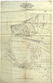
Plan, Ballaarat East Town Allotments, 1891, 18/09/1891
... T.F. McGauran...Gift of the Squire Family, 2014 Ballaarat East Town Allotments, 1891 Plan Plan T.F. McGauran ...Ballarat East was historically a separate municipality than Ballaarat. The streets developed along gold leads and early tracks. The Public Park Botanic Gardens and Recreation Reserve is now Mount Xavier Golf Course, and Ballarat Secondary College Eastern Campus. The section with Bettle's Private Property is now Saint Francis Xavier Primary School. Elford Street now appears to be the continuation of Eureka Street.Plan of Town Allotments for a portion of Ballarat East in the County of Grant. It shows Victoria Street, Clifford Street, Finlay Street, Ryan Street, Bradbury Street, Elford Street, Fussell Street, Jones Street, Park Parade, Ballarat -Geelong Railway, Eureka Street, Ballarat East Public Park Botanic Garden and Recreation Reserve. The only allotment names is Bettle's Private Property. Gift of the Squire Family, 2014ballarat east, ballaarat east, victoria street, ballarat east botanical gardens, richard squire, squire, ryan street, jones street, bradbury street, humffray steet, fussell street, elford street -
 Bacchus Marsh & District Historical Society
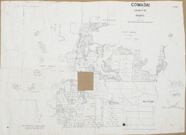
Map, Coimadai Parish Map, County of Bourke. Circa 1890s-1900s
... The date of this map is uncertain. T.F. McGauran the person who made a photo-lithographic copy of the map was in charge of photo-lithography at the Victorian Department of Lands and Survey in the late 19th century until about 1910....Photo-lithographed at the Department of Lands and Survey, Melbourne by T.F. McGauran 26.8.[??] NOTE. Photo litho from L.P showing temporary surveys and occupation of land prepared for departmental use only...The date of this map is uncertain. T.F. McGauran the person who made a photo-lithographic copy of the map was in charge of photo-lithography at the Victorian Department of Lands and Survey in the late 19th century until about 1910. ...The cadastral Parish of Coimadai, a subdivision of the County of Bourke, lies directly north of the township of Bacchus Marsh. The date of this map is uncertain. T.F. McGauran the person who made a photo-lithographic copy of the map was in charge of photo-lithography at the Victorian Department of Lands and Survey in the late 19th century until about 1910.A single page paper map showing the map for the Parish of Coimadai in the County of Bourke. A cadastral map showing parish boundaries and land ownership. A rectangle shaped area is missing from the centre of the map due to a tear or deliberate excision. The map is pasted into a bound volume containing 76 maps or plans in total. High resolution digital image stored on BMDHS computer network. Photo-lithographed at the Department of Lands and Survey, Melbourne by T.F. McGauran 26.8.[??] NOTE. Photo litho from L.P showing temporary surveys and occupation of land prepared for departmental use onlybacchus marsh region parish plans, coimadai parish maps, coimadai parish plan -
 Federation University Historical Collection
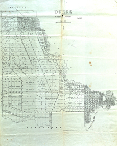
Map, Doroq County of Grenville L4935, 1911, 28 June 1911
... ...t.f. mcgauran...Gift of the Squire Family carrunge-murnong murdeduke carrah shelford inverleigh barwon river hesse wingeel george russell george russell's pre-emptive section john moffatt w. c. smith macrobie john bell thomas russell t.f. mcgauran 17 7/9 18 9 miles handwritten in pencil Photo lithographed at the Department of Lands and Survey Melbourne by T. ...This plan is associated with former Ballarat School of Mines Student Richard Squire (1875-1876). Gift of the Squire FamilyParish Plan of Doroq in black ink printed on cream paper. It includes the township of Inverleigh and Barwon Rover. Some of the names on the plan are William McRobie, William MacRobie, Thomas Russell, W.C. Smith, John Bell, J. Moffatt, Thomas Moffatt, John Anderson, George Synnot, Charles Lloyd, William MacRobie, J. Flack, Alexander Campell, T. Maher, William Berthon. Thomas Jewell, James Carstairs, D. MCInnerney, F.H. Holland, Robert Morrison17 7/9 18 9 miles handwritten in pencil Photo lithographed at the Department of Lands and Survey Melbourne by T. E. McGauran 28.6.11 Price 1/-carrunge-murnong, murdeduke, carrah, shelford, inverleigh, barwon river, hesse, wingeel, george russell, george russell's pre-emptive section, john moffatt, w. c. smith, macrobie, john bell, thomas russell, t.f. mcgauran -
Stawell Historical Society Inc
Map, Department of Lands and Survey, Borough of Stawell. Parishes of Stawell and Illawarra 1903, 1903
... Photo Lithograped at the Department of Lands and survey Melbourne by T.F. McGauran 13.6.03...Tramway, Quarry reserve, Newington Co., Galatea Co., Moonlight Co., Federal Co., Borough reservior., Surevy Photo Lithograped at the Department of Lands and survey Melbourne by T.F. McGauran 13.6.03 A0 Map of Stawell on linen backing. ...Victoria Co., St Georges Co., Wimerra Co., Leviathon Co. Tramway, Quarry reserve, Newington Co., Galatea Co., Moonlight Co., Federal Co., Borough reservior., A0 Map of Stawell on linen backing. Plus one Printed on PaperPhoto Lithograped at the Department of Lands and survey Melbourne by T.F. McGauran 13.6.03surevy -
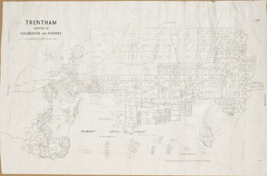 Bacchus Marsh & District Historical Society
Map, Trentham Parish Map 1905 Copy 1
... Photo-lithographed at the Department of Lands and Survey, Melbourne by T.F. McGauran 22.3.05 ...Bacchus Marsh & District Historical Society Lerderderg Library Main Street Bacchus Marsh Trentham Parish Maps Trentham Parish Plan Bacchus Marsh Region Parish Plans Photo-lithographed at the Department of Lands and Survey, Melbourne by T.F. McGauran 22.3.05 A single page paper map showing the map for the Parish of Trentham in the Counties of Dalhousie and Bourke. ...A single page paper map showing the map for the Parish of Trentham in the Counties of Dalhousie and Bourke. A cadastral map showing parish boundaries and land ownership. The map is pasted into a bound volume containing 76 maps or plans in total. High resolution digital image stored on BMDHS computer network. Photo-lithographed at the Department of Lands and Survey, Melbourne by T.F. McGauran 22.3.05 trentham parish maps, trentham parish plan, bacchus marsh region parish plans -
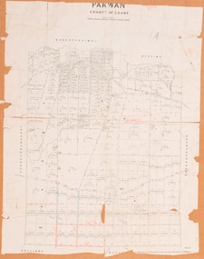 Bacchus Marsh & District Historical Society
Map, Parwan Parish Map, County of Grant, 1909
... Photo-lithographed at the Department of Lands and Survey, Melbourne by T.F. McGauran, 7.7.09. ...Bacchus Marsh & District Historical Society Lerderderg Library Main Street Bacchus Marsh Bacchus Marsh Region Parish Plans Parwan Parish Maps Parwan Parish Plan Photo-lithographed at the Department of Lands and Survey, Melbourne by T.F. McGauran, 7.7.09. A single page paper map showing the map for the Parish of Parwan in the County of Grant. ...A single page paper map showing the map for the Parish of Parwan in the County of Grant. A cadastral map showing parish boundaries and land ownership. The map is pasted into a bound volume containing 76 maps or plans in total. High resolution digital image stored on BMDHS computer network. Photo-lithographed at the Department of Lands and Survey, Melbourne by T.F. McGauran, 7.7.09. bacchus marsh region parish plans, parwan parish maps, parwan parish plan -
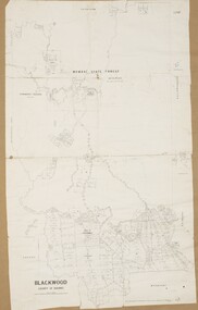 Bacchus Marsh & District Historical Society
Map, Blackwood Parish Map, County of Bourke, 1892
... Photo-lithographed at the Department of Lands and Survey, Melbourne by T.F. McGauran 14.7.92...Bacchus Marsh & District Historical Society Lerderderg Library Main Street Bacchus Marsh Bacchus Marsh Region Parish Plans Blackwood Parish Plan Blackwood Parish Maps Photo-lithographed at the Department of Lands and Survey, Melbourne by T.F. McGauran 14.7.92 A single page paper map showing the map for the Parish of Blackwood in the County of Bourke. ...A single page paper map showing the map for the Parish of Blackwood in the County of Bourke. A cadastral map showing parish boundaries and land ownership. The map is pasted into a bound volume containing 76 maps or plans in total. High resolution digital image stored on BMDHS computer network. Photo-lithographed at the Department of Lands and Survey, Melbourne by T.F. McGauran 14.7.92bacchus marsh region parish plans, blackwood parish plan, blackwood parish maps -
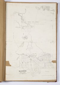 Bacchus Marsh & District Historical Society
Map, Blackwood Parish Map, County of Bourke, 1905
... Photo-lithographed at the Department of Lands and Survey, Melbourne by T.F. McGauran 21.7.05...Bacchus Marsh & District Historical Society Lerderderg Library Main Street Bacchus Marsh Bacchus Marsh Region Parish Plans Blackwood Parish Plan Blackwood Parish Maps Photo-lithographed at the Department of Lands and Survey, Melbourne by T.F. McGauran 21.7.05 A single page paper map showing the map for the Parish of Blackwood in the County of Bourke. ...A single page paper map showing the map for the Parish of Blackwood in the County of Bourke. A cadastral map showing parish boundaries and land ownership. The map is pasted into a bound volume containing 76 maps or plans in total. High resolution digital image stored on BMDHS computer network. Photo-lithographed at the Department of Lands and Survey, Melbourne by T.F. McGauran 21.7.05bacchus marsh region parish plans, blackwood parish plan, blackwood parish maps -
Stawell Historical Society Inc
Map, Lexington County of Borong 1910 & 1914, 1910
... Photo Lithographed at the Department of Lands and Survey. Melbourne by T.F. McGauran 5.12.10 & W.J. Butson 24.3.14...Stawell Historical Society Inc 46 Longfield St Stawell grampians Parish to the North East of Moyston Survey Photo Lithographed at the Department of Lands and Survey. Melbourne by T.F. McGauran 5.12.10 & W.J. Butson 24.3.14 A2 Parish map Lexington County of Borong 1910 & 1914 Map T.F. ...Parish to the North East of MoystonA2 Parish mapPhoto Lithographed at the Department of Lands and Survey. Melbourne by T.F. McGauran 5.12.10 & W.J. Butson 24.3.14survey -
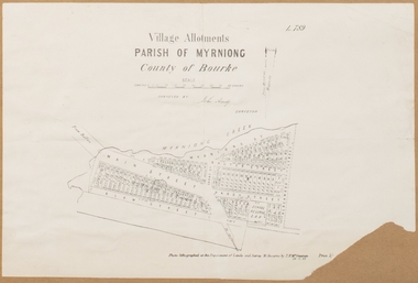 Bacchus Marsh & District Historical Society
Map, Village allotments, Parish of Myrniong, County of Bourke
... Surveyed by John Hardy, Surveyor ; photo-lithographed at the Department of Lands & Survey, Melbourne by T.F. McGauran, 24.12.03...Myrniong Parish Plan Myrniong Parish Maps Surveyed by John Hardy, Surveyor ; photo-lithographed at the Department of Lands & Survey, Melbourne by T.F. McGauran, 24.12.03 A single page paper map. ...Myrniong is a village 9 kilometers west of Bacchus Marsh. Prior to 1863 the area was known as Blow's Flat. This map which was produced in 1903 and according to the catalogue record of this map held at the State Library of Victoria was based on an earlier map created in 1861. The early layout of streets for the village of Myrniong can be seen on this map. The streets shown are, Main Street, Hardy Street, Blow Street, Myrniong Street, Shuter Street, and Blackwood Street. An area marked as a reserve for a school can be seen between Hardy Street and Main Street.A single page paper map. A cadastral parish map of Myrniong in Victoria, showing numbered land allotments. Photo-lithographed at the Department of Lands & Survey, Melbourne, in 1903. Based on an original map created in 1861. The map is pasted into a bound volume containing 76 maps or plans in total. High resolution digital image stored on BMDHS computer network. Surveyed by John Hardy, Surveyor ; photo-lithographed at the Department of Lands & Survey, Melbourne by T.F. McGauran, 24.12.03myrniong parish plan, myrniong parish maps -
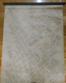 Bendigo Historical Society Inc.
Map - MAP: BENDIGO SHEET 2, 1910, 1910
... Map prepared by Department of Lands and Survey, Melbourne by T.F. McGauran 4.1.10 (1910)...Map prepared by Department of Lands and Survey, Melbourne by T.F. McGauran 4.1.10 (1910) Map MAP: BENDIGO SHEET 2, 1910 ...Map. Map with timber ends, showing names of property owners. Bendigo from Olinda Street west to Prouses Road and Bennet / Wattle Street to Dooley Street in the north. Copy of map taken for research purposes. Map prepared by Department of Lands and Survey, Melbourne by T.F. McGauran 4.1.10 (1910)map, bendigo, residence areas, 1910 -
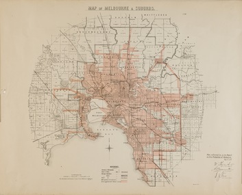 Kew Historical Society Inc
Map, Department of Lands & Survey, Map of Melbourne & Suburbs, 1899
... "MAP OF MELBOURNE & SUBURBS / Plan referred to in the Report on Fire Protection in Melbourne, May 6th 1899 / Scale 80 Chains to 1 inch / Photo-lithographed at the Department of Lands and Survey Melbourne by T.F. McGauran, 1891" / May 1899 No.76"...While by 1910, there were 123,227 connections to Melbourne's water supply system, it is unclear in this 1899 map whether water was supplied to all built structures in the defined areas or only to fire hydrants and stand pipes. water reticulation -- melbourne (vic.) department of lands & survey -- historic maps fire brigades -- melbourne (vic.) cartography "MAP OF MELBOURNE & SUBURBS / Plan referred to in the Report on Fire Protection in Melbourne, May 6th 1899 / Scale 80 Chains to 1 inch / Photo-lithographed at the Department of Lands and Survey Melbourne by T.F. McGauran, 1891" / May 1899 No.76" Map accompanying report on fire protection of Melbourne showing those areas with water supplies tinted. ...The Metropolitan Fire Brigades Board commenced service on 1 May 1891. Melbourne and its surrounding suburbs were divided into 5 sub districts each with a district superintendent and paid firefighters with additional support from paid auxiliaries. This map was produced on 6 May 1899 by the Department of Lands & Survey Melbourne showing the distribution of water in Melbourne for use by fire brigades. While by 1910, there were 123,227 connections to Melbourne's water supply system, it is unclear in this 1899 map whether water was supplied to all built structures in the defined areas or only to fire hydrants and stand pipes.Map accompanying report on fire protection of Melbourne showing those areas with water supplies tinted."MAP OF MELBOURNE & SUBURBS / Plan referred to in the Report on Fire Protection in Melbourne, May 6th 1899 / Scale 80 Chains to 1 inch / Photo-lithographed at the Department of Lands and Survey Melbourne by T.F. McGauran, 1891" / May 1899 No.76"water reticulation -- melbourne (vic.), department of lands & survey -- historic maps, fire brigades -- melbourne (vic.), cartography