Kiewa Valley Historical Society
Maps - Tawonga and Feathertop
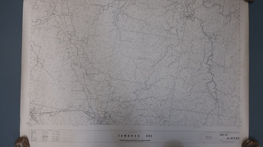
... tawonga map 1968...Topographical Map - Tawonga 803 Forests Commission of Victoria 1968. Cream paper with black print. ...Kiewa Valley Historical Society Mount Beauty Information Centre 31 Bogong High Plains Rd Mt Beauty high-country Plan of Tawonga showing roads etc, rivers, use of land in 1968 and of Feathertop in 1969. Historical use of land in Tawonga and Feathertop. tawonga map 1968 tawonga parishes feathertop map 1969 1. ...
Plan of Tawonga showing roads etc, rivers, use of land in 1968 and of Feathertop in 1969.Historical use of land in Tawonga and Feathertop.1. Topographical Map - Tawonga 803 Forests Commission of Victoria 1968. Cream paper with black print. Legend: Roads, tracks etc, rivers, Parishes and use of land.
2. Feathertop 813. 1969tawonga map 1968, tawonga parishes, feathertop map 1969