Showing 888 items matching "three mile"
-
 The Beechworth Burke Museum
Photograph - Photograph - Reproduction, c1920
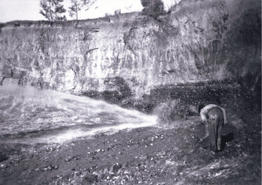
... ...three mile mine...Many miners would leave Three Mile Mine for better prospects on other claims. ...reverse: 7597.4 / copied from original on loan from Webb (Qld) / Donated Nov 2009 / Baarmutha Three Mile Mine 1920-1950 / Owned by Plain Bros then Parkinsons / John Weir or Jack Cox / Sluicing /...Many miners would leave Three Mile Mine for better prospects on other claims. ...This photograph depicts mining operations (in particular, hydrolic sluicing) at Three Mile Mine, Barramutha, during the later periods of mining, 1920s-1950s. Three Mile Mine was a major site of mining activity sating back to the 1850s, although was often not as prosperous as other sites such as those situated on the Woolshed Valley. Many miners would leave Three Mile Mine for better prospects on other claims. The main, most successful 'rush' at Three Mile Mine occurred during and immediately following September 1855. This photograph, however, depicts a much later period.The search for gold is ingrained into the history of Victoria and therefore, images like this one which portray a miner at a sluicing site can reveal important information for society and technology for the date when the photograph was taken. This image, and its related images, it important for its historical significant of labour and mining extraction used for gold during the latter gold rushes in the 1900s. The Beechworth Burke Museum has additional images relating to gold mining in the region which can be analysed and studied alongside images like this one.A black and white rectangular photograph printed on matte photographic paperreverse: 7597.4 / copied from original on loan from Webb (Qld) / Donated Nov 2009 / Baarmutha Three Mile Mine 1920-1950 / Owned by Plain Bros then Parkinsons / John Weir or Jack Cox / Sluicing /mining, barramutha, three mile mine, sluicing, mine, beechworth -
 The Beechworth Burke Museum
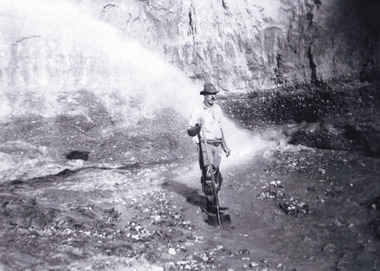
Photograph, 1920 - 1930
... three mile creek...Taken between circa 1920 - 1930 this photograph depicts a Hydraulic water jet in the foreground and a man dressed in dark trousers, a white long sleeved shirt and broad-brimmed workers hat digging around in the Three Mile Mine at Barramutha. The mine was an important gold resource and was typically mined using a method known as hydraulic sluicing whereby high powered water jets are used to dislodge rock or move sediment. ...Reverse: Copied from original on loan from Webb (QLD)/ Donated Nov 2009/ Barnawatha Three Mile Mine c1920-1950/ Owned by Plain Bros then Parkinsons/ Managed by John Weir, Peter Jenson, Jack Cox/ Slicing. ...It also shows the evolution of the mining methods and has potential for understanding future engineering endeavors in the context of victorian mine goldfields. three mile creek three mile goldfields three mile beechworth Goldfields #beechworth Hydraulic mining Hydraulic Sluice Burke Museum Reverse: Copied from original on loan from Webb (QLD)/ Donated Nov 2009/ Barnawatha Three Mile Mine c1920-1950/ Owned by Plain Bros then Parkinsons/ Managed by John Weir, Peter Jenson, Jack Cox/ Slicing. ...Taken between circa 1920 - 1930 this photograph depicts a Hydraulic water jet in the foreground and a man dressed in dark trousers, a white long sleeved shirt and broad-brimmed workers hat digging around in the Three Mile Mine at Barramutha. The mine was an important gold resource and was typically mined using a method known as hydraulic sluicing whereby high powered water jets are used to dislodge rock or move sediment. The remaining water sediment slurry is directed through sluice boxes to remove the gold. The Beechworth mining district was one of six mining districts established by the governor-in-council on 4th of January 1858 under the provisions of An Act for Amending the Laws Relating to the Goldfields (21 Vic no. 32).This photograph shows cultural and research value into the historical methods of hydraulic sluicing in the Beechworth mining disctrict. It also shows the evolution of the mining methods and has potential for understanding future engineering endeavors in the context of victorian mine goldfields.Black and White rectangular photograph printed on matte photographic paper. Reverse: Copied from original on loan from Webb (QLD)/ Donated Nov 2009/ Barnawatha Three Mile Mine c1920-1950/ Owned by Plain Bros then Parkinsons/ Managed by John Weir, Peter Jenson, Jack Cox/ Slicing. three mile creek, three mile goldfields, three mile beechworth, goldfields, #beechworth, hydraulic mining, hydraulic sluice, burke museum -
 The Beechworth Burke Museum
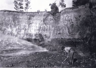
Photograph, Circa 1920 - 1950
... three mile creek...Taken between circa 1920 - 1950 this photograph depicts a man dressed in dark trousers, a white long sleeved shirt and broad-brimmed workers hat digging around in the Three Mile Mine at Barramutha. The mine was an important gold resource and was typically mined using a method known as hydraulic sluicing whereby high powered water jets are used to dislodge rock or move sediment. ...Reverse: 7597.3/ Copied from original on loan from Webb (QLD)/ Donated Nov 2009/ Barnawatha Three Mile Mine 1920-1950/ Owned by Plain Bros then Parkinsons/ Managed by John Weir, Peter Jenson, Jack Cox/ Slicing. ...It also shows the evolution of the mining methods and has potential for understanding future engineering endeavors in the context of victorian mine goldfields. three mile creek three mile goldfields three mile beechworth Goldfields #beechworth Hydraulic mining Hydraulic Sluice Burke Museum Reverse: 7597.3/ Copied from original on loan from Webb (QLD)/ Donated Nov 2009/ Barnawatha Three Mile Mine 1920-1950/ Owned by Plain Bros then Parkinsons/ Managed by John Weir, Peter Jenson, Jack Cox/ Slicing. ...Taken between circa 1920 - 1950 this photograph depicts a man dressed in dark trousers, a white long sleeved shirt and broad-brimmed workers hat digging around in the Three Mile Mine at Barramutha. The mine was an important gold resource and was typically mined using a method known as hydraulic sluicing whereby high powered water jets are used to dislodge rock or move sediment. The remaining water sediment slurry is directed through sluice boxes to remove the gold. The Beechworth mining district was one of six mining districts established by the governor-in-council on 4th of January 1858 under the provisions of An Act for Amending the Laws Relating to the Goldfields (21 Vic no. 32). This photograph shows historic and research value into the historical methods of hydraulic sluicing in the Beechworth mining disctrict. It also shows the evolution of the mining methods and has potential for understanding future engineering endeavors in the context of victorian mine goldfields. Black and white rectangular photograph printed on matte photographic paper.Reverse: 7597.3/ Copied from original on loan from Webb (QLD)/ Donated Nov 2009/ Barnawatha Three Mile Mine 1920-1950/ Owned by Plain Bros then Parkinsons/ Managed by John Weir, Peter Jenson, Jack Cox/ Slicing. three mile creek, three mile goldfields, three mile beechworth, goldfields, #beechworth, hydraulic mining, hydraulic sluice, burke museum -
 The Beechworth Burke Museum
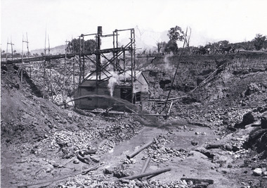
Photograph, 1920 - 1930
... three mile creek...Taken between circa 1920 - 1950 this photograph depicts the open mine in the Three Mile Mine at Barramutha. The mine was an important gold resource and was typically mined using a method known as hydraulic sluicing whereby high powered water jets are used to dislodge rock or move sediment. ...Reverse: Copied from original on loan from Webb (QLD)/ Donated Nov 2009/ Barnawatha Three Mile Mine c1920-1950 Minehead & Slicing/ Managed by John Weir, Peter Jensen, Jack Cox/ Owned by/ the Plain Bros then Parkinsons/ John worked for Pqarkinsons. ...It also shows the evolution of the mining methods and has potential for understanding future engineering endeavors in the context of victorian mine goldfields. three mile creek three mile goldfields three mile beechworth Goldfields #beechworth Hydraulic mining Hydraulic Sluice Burke Museum Reverse: Copied from original on loan from Webb (QLD)/ Donated Nov 2009/ Barnawatha Three Mile Mine c1920-1950 Minehead & Slicing/ Managed by John Weir, Peter Jensen, Jack Cox/ Owned by/ the Plain Bros then Parkinsons/ John worked for Pqarkinsons. ...Taken between circa 1920 - 1950 this photograph depicts the open mine in the Three Mile Mine at Barramutha. The mine was an important gold resource and was typically mined using a method known as hydraulic sluicing whereby high powered water jets are used to dislodge rock or move sediment. The remaining water sediment slurry is directed through sluice boxes to remove the gold. The Beechworth mining district was one of six mining districts established by the governor-in-council on 4th of January 1858 under the provisions of An Act for Amending the Laws Relating to the Goldfields (21 Vic no. 32).This photograph shows cultural and research value into the historical methods of hydraulic sluicing in the Beechworth mining disctrict. It also shows the evolution of the mining methods and has potential for understanding future engineering endeavors in the context of victorian mine goldfields.Black and White rectangular photograph printed on matte photographic paper.Reverse: Copied from original on loan from Webb (QLD)/ Donated Nov 2009/ Barnawatha Three Mile Mine c1920-1950 Minehead & Slicing/ Managed by John Weir, Peter Jensen, Jack Cox/ Owned by/ the Plain Bros then Parkinsons/ John worked for Pqarkinsons. three mile creek, three mile goldfields, three mile beechworth, goldfields, #beechworth, hydraulic mining, hydraulic sluice, burke museum -
 The Beechworth Burke Museum
Photograph, 1920-1950
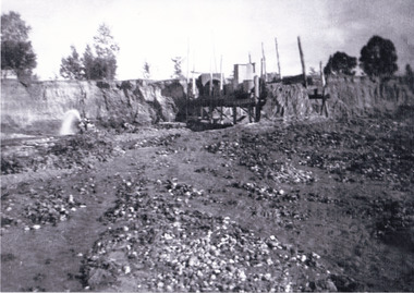
... ...three mile creek...This image taken between 1920-1930 depicts open-cut hydraulic sluicing at the Three Mile Mine, located about five kilometres south of Beechworth. ...Reverse: 7597-1 / Sluice Mining / Copied from original on loan from Webb (Qld) / Donated Nov 2009 / Baarmutha Three Mile Mine c1920-1950 / Managed by the Plain Bros then Parkinsons / Current Location is: Beechworth Animal Shelter / used for Baarmutha...The Beechworth Burke Museum Loch Street Beechworth high-country This image taken between 1920-1930 depicts open-cut hydraulic sluicing at the Three Mile Mine, located about five kilometres south of Beechworth. ...This image taken between 1920-1930 depicts open-cut hydraulic sluicing at the Three Mile Mine, located about five kilometres south of Beechworth. Alluvial, or surface, mining began on this site in the 1850s, but was soon replaced by hydraulic sluicing methods. By the start of 1880 it is estimated that nine hundred miles of water races had been cut though soil and rock in the Beechworth district. Hydraulic sluicing employs high pressure jets of water to blast away large areas of earth and wash it down to be run through a sluice box. Gold gets caught in the sluice and the remaining slurry is washed away. Large water quantities were required for hydraulic sluicing, and the long water races and deep tailraces that were constructed were considered great engineering feats. This method of mining is extremely effective, but causes significant environmental damage and impacts to waterways and agricultural operations. Miners at Beechworth built extensive networks of races and dams to secure reliable supplies of water on a scale far greater than elsewhere in Victoria. By the 1880s Beechworth's water barons continued to hold more than half of all the water right licences on issue and undertook sluicing operations on a massive scale. The manipulation of surface and ground water via race networks was well planned and recorded in detail by local mining surveyors. The maps that were created, combined with modern geo-spatial technologies, provide a vital key in understanding the great lengths to which miners went to capture and control critical water resources. Today, Three Mile mine is called Baarmutha. The Three Mile Mine was unproductive until 1865 when John Pund and three other miners secured a fifteen year license and constructed a water race from Upper Nine Mile Creek to Three Mile Creek. In the early twentieth century Pund & Co. averaged over one thousand ounces of gold per year from the mine. After Pund's death in 1915, GSG Amalgamated Co operated the site, continuing sluicing until 1950. This image of hydraulic sluicing methods shows the extent of water-works engineering in the landscape. This photograph has historic and research potential for understanding changes to the landscape, the evolution of mining methods, and the extensive construction, manipulation and management of water networks in the Beechworth district. Black and white rectangular photograph on matte paperReverse: 7597-1 / Sluice Mining / Copied from original on loan from Webb (Qld) / Donated Nov 2009 / Baarmutha Three Mile Mine c1920-1950 / Managed by the Plain Bros then Parkinsons / Current Location is: Beechworth Animal Shelter / used for Baarmuthaburke museum, beechworth museum, beechworth, gold fields, gold rush, victorian gold rush, hydraulic sluicing, spring creek, netwown falls, mining tunnels, water races, tailraces, gold ming history, colonial australia, australian gold rushes, mining technology, beechworth historic district, indigo gold trail, indigo shire, john pund, water manipulation, water engineering, three mile creek, three mile mine, water race, large-scale mining methods, historical mining construction, alluvial mining, mining environmental impacts, baarmutha, water barons -
 The Beechworth Burke Museum
Photograph - Photograph - Reproduction, Unknown c1852-1940
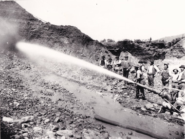
... ...Three Mile Creek...The miners are located in the Three Mile Creek division, in the Beechworth Mining District established January 4th 1858 under An Act for Amending the Laws Relating to the Goldfields by the Governor-in-Council. ...Beechworth Mining District Mining Three Mile Creek Division Three Mile Creek Black and white rectangular photograph printed on matte photographic paper, unmounted print. ...Depicted in the photograph are ten miners standing at a cliff face using a high pressure hose, in Beechworth, Victoria. The miners are located in the Three Mile Creek division, in the Beechworth Mining District established January 4th 1858 under An Act for Amending the Laws Relating to the Goldfields by the Governor-in-Council. The Ovens Gold Rush began at Beechworth in February 1852 and was followed by Yackandandah and the 'Indigo Goldfield'. The strategies applied to mining in Beechworth were distinct in comparison to other goldfields in Victoria such as Bendigo and Ballarat. The miners in Beechworth utlised 'hydraulic sluicing' to remove washdirt, the long water races and deep tailraces constructed through solid rock with an estimated 900 miles of water races cut through the Beechworth fields by 1880, demonstrating great engineering feats. The photograph taken is significant as it is a visual representation of the mining strategy, 'hydraulic sluicing' that was particularly unique to the Beechworth mines, particularly in Victoria and an engineering feat.Black and white rectangular photograph printed on matte photographic paper, unmounted print.beechworth mining district, mining, three mile creek division, three mile creek -
 The Beechworth Burke Museum
Photograph - Photograph - Reproduction, W. D. Gibbon, Early 1900s
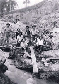
... ...three mile creek...This photograph was taken in 1911 at Three Mile Creek, about five kilometers south of Beechworth town. ...The Beechworth Burke Museum Loch Street Beechworth high-country This photograph was taken in 1911 at Three Mile Creek, about five kilometers south of Beechworth town. ...This photograph was taken in 1911 at Three Mile Creek, about five kilometers south of Beechworth town. Significant digging took place at this location from late 1855, which led to a flood of workers and stores to follow, though daily earnings were slim compared to the nearby Woolshed site. This remained the case even after workers at Three Mile Creek attempted to protest around Beechworth during an election in November 1855. Three Mile Creek was one of seven significant divisions of the Beechworth Mining District formalised by the Governor-in-Council in 1858, though by the time this photograph was taken, the boundaries of the original seven districts had shifted to create seventeen divisions. The Three Mile Goldfields was a site of rich alluvial gold deposits located about 5km south of Beechworth in Victoria. Today, the location of this gold deposit is called Baarmutha. It was a popular area for gold mining in the 1850s but became largely abandoned by the following decade. In 1865, a man named John Pund (a man second from the left in the back row of this photograph shares this surname) recognized that the area could be potentially rich if a better water supply could be obtained. He secured a 15 year license with three other miners. Within the next five years, these men had constructed 19 km of water race going from Upper Nine Mile Creek to Three Mile Creek. By 1881, these four men had delivered 950,000 gallons to the Three Mile Sluicing area which is depicted in this photograph. Pund would later go into partnership with John Alston Wallace who would become owner of the Star Hotel in Beechworth. The Three Mile sluicing location continued to be operational until 1950. The eleven miners in this photograph are: Back row: Led Guthrie, P. Pund, F. Beel, [Unknown] Miller Front row: Paddy McNamara, J. King, W. Beel, [Unknown] Garland, J. Clarke, J. Ryan, H. Bartsh In the background of the photograph is a huge dirt wall that appears to suffer damage caused by hydraulic sluicing. Hydraulic sluicing is a specialised mining technique that involves directing high pressure water flows at dirt to uncover gold. The technique played a significant role in shaping Beechworth's landscape during the gold rush to create the topography seen today.The search for gold is ingrained into the history of Victoria and therefore, images like this one which portray an open cut sluicing site can reveal important information for society and technology for the date when the photograph was taken. This image is of important historical significance for its ability to convey information about sluicing and the methods used to find gold in the late 1800s and early 1900s. It also shows a location where sluicing was undertook which provides insight into the impact of sluicing on the environment at a time when it was done. Images, like this one, of Australian gold rush history can reveal important information about the social and environmental impact of this period. This image depicts diggers standing in a mining location and therefore, this image has the capacity to reveal or support significant information for researchers studying the fashion and social status of diggers in Australia in approximately 1911. It can also provide information on the landscape of Australia in this period and the impact of mining for gold on both society and the Australian landscape. The Burke Museum is home to a substantial collection of Australian mining photographs which can be used to gain a deeper understanding into life on the gold fields, technology used in mining, the miners themselves and the impact of the gold digging on the environment.Black and white / sepia rectangular reproduced photograph printed on glossy photographic paper mounted on board.beechworth, beechworth museum, mining, mining team, three mile creek, sluicing, hydraulic sluicing, photography, gold sluicing, gold mining, pund mining -
 The Beechworth Burke Museum
Photograph, c.1870
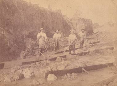
... three mile goldfields...This photograph was taken in approximately 1870 and depicts four male miners standing in mining sluice at the Three Mile Goldfields. These men are wearing typical attire for 1870s gold miners. ...The image depicts the landscape of the Three Mile Goldfields during a period when open cut sluicing was undertaken to reach gold. ...This photograph was taken in approximately 1870 and depicts four male miners standing in mining sluice at the Three Mile Goldfields. These men are wearing typical attire for 1870s gold miners. They wear white shirts, tan coloured pants with water proof shoes and most of the men are wearing an apron to prevent their clothing from becoming too dirty from the mud. Each man is wearing a wide brim hat and hold large wooden tools used for sorting through the sluice. Three of the four men have full beards. The photograph was donated to the Burke Museum by R. Ziegenbein before 2001 but the photographer and the individuals captured in the photo are unknown. The image depicts the landscape of the Three Mile Goldfields during a period when open cut sluicing was undertaken to reach gold. Open cut sluicing is a method used to extract gold and other precious metals from beneath the surface of the earth. This technique involved the use of high-powered hoses which broke down the soil enabling miners to come along and search this soil for gold. After the gold rush of the early 1850s, diggers had to enlist the assistance of heavy machinery and techniques like hydraulic sluicing in order to reach gold because the surface alluvial gold had already been discovered and removed. This heavy machinery was not used until after 1853. The Three Mile Goldfields was a site of rich alluvial gold deposits located about 5 km south of Beechworth in Victoria. Today, the location of this gold deposit is called Baarmutha. It was a popular area for gold mining in the 1850s but became largely abandoned by the following decade. In 1865, a man named John Pund recognized that the area could be potentially rich if a better water supply could be obtained. He secured a 15 year license with three other miners. Within the next five years, these men had constructed 19 km of water race going from Upper Nine Mile Creek to Three Mile Creek. By 1881, these four men had delivered 950,000 gallons to the Three Mile Sluicing area which is depicted in this photograph. Pund was later go into partnership with John Alston Wallace who would become owner of the Star Hotel in Beechworth. The Three Mile sluicing location continued to be operational until 1950. Sluice box workers were a vital part of gold mining regardless of how inefficient they were in the recovery of gold. After using hydraulic sluicing to cut away the earth, miners would use the big wooden boxes depicted in the image to catch the earth which would then be sifted for gold. However, accidents would occur often which would result in the gold washing away and unable to be recovered. It was not a very efficient system because the gold, which was alluvial and thus very fine, would often pass through the sluice box undetected.The search for gold is ingrained into the history of Victoria and therefore, images like this one which portray an open cut sluicing site can reveal important information for society and technology for the date when the photograph was taken. This image is of important historical significance for its ability to convey information about sluicing and the methods used to find gold in the late 1800s and early 1900s. It also shows a location where sluicing was undertook which provides insight into the impact of sluicing on the environment at a time when it was done. Images, like this one, of Australian gold rush history can reveal important information about the social and environmental impact of this period. This image depicts diggers standing in a mining location and therefore, this image has the capacity to reveal or support significant information for researchers studying the fashion and social status of diggers in Australia in approximately 1870. It can also provide information on the landscape of Australia in this period and the impact of mining for gold on both society and the Australian landscape. The Burke Museum is home to a substantial collection of Australian mining photographs which can be used to gain a deeper understanding into life on the gold fields, technology used in mining, the miners themselves and the impact of the gold digging on the environment.Sepia toned rectangular photograph printed on matte photographic paper and mounted on board.[illegible] about 1870 / 97 2514.1 / 2594 30three mile goldfields, goldfields, 1870, 1870 gold, australia, australian landscape, miners, gold miners, diggers, gold diggers, beechworth, victoria, sluice box workers, sluicing, sluice, mining -
 The Beechworth Burke Museum
Audio - Oral History, Jennifer Williams, Wilma Wells, 10th February 2000
... ...three mile...Born on the 24th of December 1912 at the Three Mile was Wilma Wells. Her mother born into English heritage bore four children, one who died shortly after birth, while her father had Irish heritage and worked at May Day Hills as a warden and a nurse. ...The Beechworth Burke Museum Loch Street Beechworth high-country Born on the 24th of December 1912 at the Three Mile was Wilma Wells. Her mother born into English heritage bore four children, one who died shortly after birth, while her father had Irish heritage and worked at May Day Hills as a warden and a nurse. ...Born on the 24th of December 1912 at the Three Mile was Wilma Wells. Her mother born into English heritage bore four children, one who died shortly after birth, while her father had Irish heritage and worked at May Day Hills as a warden and a nurse. Wilma married Ted Wells when she was 23 and subsequently had two daughters. This oral history recording was part of a project conducted by Jennifer Williams in the year 2000 to capture the everyday life and struggles in Beechworth during the twentieth century. This project involved recording seventy oral histories on cassette tapes of local Beechworth residents which were then published in a book titled: Listen to what they say: voices of twentieth century Beechworth. These cassette tapes were digitised in July 2021 with funds made available by the Friends of the Burke. Wilma Wells account of her life during the 20th century is historically and socially significant to the cultural heritage of Beechworth and the surrounding regions. She details important historical places and hardships within the region that have a lasting impact which includes but is not limited to issues with race, women's societal expectations and economic struggles. This oral history account is socially and historically significant as it is a part of a broader collection of interviews conducted by Jennifer Williams which were published in the book 'Listen to what they say: voices of twentieth-century Beechworth.' While the township of Beechworth is known for its history as a gold rush town, these accounts provide a unique insight into the day-to-day life of the town's residents during the 20th century, many of which will have now been lost if they had not been preserved.This is a digital copy of a recording that was originally captured on a cassette tape. The cassette tape is black with a horizontal white strip and is currently stored in a clear flat plastic rectangular container. It holds up 40 minutes of recordings on each side.Mrs Wilma Wells /beechworth, may day hills, oral history, burke museum, wilma wells, hospital, listen, weddings, three mile, picnic -
 The Beechworth Burke Museum
Audio - Oral History, Jennifer Williams, Evelyn Jensen, 13th April 2000
... ...three mile creek...Mytleford Road Beechworth three mile creek three mile beechworth twin nozzleman Goldrush gold rush work mother young mother children siblings baby grandmother father isolation bush water watertanks kerosene tins wash day bath day creek gardening provide poor money oral history twentieth century recording story Evelyn Jensen / This is a digital copy of a recording that was originally captured on a cassette tape. ...Miss Evelyn Jensen was born in 1908 near Mytleford Road in Beechworth. Miss Jensen was a twin but she also had twelve brothers and sisters. Miss Jensen went to school when she was nine years old but did not enjoy it. Her father was a nozzleman and had a role in finding and collecting gold. More specifically, a nozzleman operated a steel barrel with an interchangeable brass nozzle that sprayed high pressure water onto rock and similar surfaces. This broke down the surface for gold to be found. Unfortunately, when he began most of the gold was already gone. Miss Jensen's mother died when Miss Jensen was sixteen. As a result, Miss Jensen had to take care of the children and run the house. This included looking after a few months old baby. Her father was away at work most days so all of the responsibility fell on her. Her grandmother was present but she was too old to help Miss Jensen. Miss Jensen and her family lived a very long way from the main town and often had to carry kerosene tins full of water half a mile to their house. This was because they have no access to water at their home. This lack of water also meant they had to either bathe in the creek or carry the water back home for a bath. On wash day, they washed their clothes in the creek too. Miss Jensen never married but continued to provide for her family. She spent her days gardening and cooking. They did not have much money so gardening was a way that they provided food for themselves. This oral history recording was part of a project conducted by Jennifer Williams in the year 2000 to capture the everyday life and struggles in Beechworth during the twentieth century. This project involved recording seventy oral histories on cassette tapes of local Beechworth residents which were then published in a book titled: Listen to what they say: voices of twentieth century Beechworth. These cassette tapes were digitised in July 2021 with funds made available by the Friends of the Burke.Miss Jensen's oral history is significant because it demonstrates the struggles of living remotely during this early part of the twentieth century. When Miss Jensen's mother died, she had to take on a lot of responsibility and did not have much support. This history sheds light on these struggles of being a young caregiver but it also gives details on how large families lived in isolated places. An example of this is the way that Miss Jensen often had to do the washing in the creek because that was the only place there was running water. In addition, Miss Jensen's story is significant because her father was a nozzleman. It indicates one of the processes was used to find gold. This oral history account is socially and historically significant as it is a part of a broader collection of interviews conducted by Jennifer Williams which were published in the book 'Listen to what they say: voices of twentieth-century Beechworth.' While the township of Beechworth is known for its history as a gold rush town, these accounts provide a unique insight into the day-to-day life of the town's residents during the 20th century, many of which will have now been lost if they had not been preserved.This is a digital copy of a recording that was originally captured on a cassette tape. The cassette tape is black with a horizontal white strip and is currently stored in a clear flat plastic rectangular container. It holds up 40 minutes of recordings on each sideEvelyn Jensen /mytleford road, beechworth, three mile creek, three mile beechworth, twin, nozzleman, goldrush, gold rush, work, mother, young mother, children, siblings, baby, grandmother, father, isolation, bush, water, watertanks, kerosene tins, wash day, bath day, creek, gardening, provide, poor, money, oral history, twentieth century, recording, story -
 The Beechworth Burke Museum
Photograph - Lantern Slide, c1900
... ...three mile...Forty-three country lots were initially offered in the Three Mile area, ranging in size from two to ninety acres and costing from £1 to £3 per acre. ...Forty-three country lots were initially offered in the Three Mile area, ranging in size from two to ninety acres and costing from £1 to £3 per acre. ...Miners from Snake Valley lobbied the Victorian Government in 1855 to make land available for sale for farming purposes as an alternative occupation and income for people who wished to stay in the region but move away from gold mining. A secondary motivation was to increase the supply of fresh produce and decrease prices of items that otherwise needed to be transported from Melbourne or other regions. Forty-three country lots were initially offered in the Three Mile area, ranging in size from two to ninety acres and costing from £1 to £3 per acre. An additional eighty-five country lots were auctioned later in the year, in addition to many smaller suburban lots. More lots were offered than sold, initially, but this represented conditions of sale requiring the total purchase cost up front which many people interested in purchasing could not afford, especially as land purchased for farming would accrue substantial additional costs for clearing and labour before becoming productive. Further lobbying activities and the election of parliamentary members sympathetic to the cause took place through the 1850s. Ovens Parliamentary Member, Daniel Cameron, was re-elected in 1856 on a platform of surveying the land for public selection with deferred payment options. Land reform remained an issue in the area through the 1850s and early 1860s, impacting broader decisions in the new State of Victoria relating to voting rights, use of Crown land and the farming of land that wasn't always suitable for the purpose. This photograph depicts Beechworth in approximately 1900, after several waves of land sales resulted in increasingly levels of development. Lantern slides, sometimes called 'magic lantern' slides, are glass plates on which an image has been secured for the purpose of projection. Glass slides were etched or hand-painted for this purpose from the Eighteenth Century but the process became more popular and accessible to the public with the development of photographic-emulsion slides used with a 'Magic Lantern' device in the mid-Nineteenth Century. Photographic lantern slides comprise a double-negative emulsion layer (forming a positive image) between thin glass plates that are bound together. A number of processes existed to form and bind the emulsion layer to the base plate, including the albumen, wet plate collodion, gelatine dry plate and woodburytype techniques. Lantern slides and magic lantern technologies are seen as foundational precursors to the development of modern photography and film-making techniques.This glass slide is significant because it provides insight into Beechworth's built environment and infrastructure in the early Twentieth Century, around the time of Australia's Federation. It is also an example of an early photographic and film-making technology in use in regional Victoria in the time period.Thin translucent sheet of glass with a square-edged image printed on the front and framed in a black backing. It is held together by metal strips to secure the edges of the slide.burke museum, beechworth, lantern slide, slide, glass slide, plate, burke museum collection, photograph, monochrome, indigo shire, north-east victoria, farming, squatters, miners, agriculture, land-clearing, land reform, daniel cameron, land sales, three mile, snake valley, tarrawingee -
 The Beechworth Burke Museum
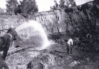
Photograph, c1920
... The District was further divided into seven divisions: Spring Creek, Snake Valley, Three Mile Creek, Buckland, Woolshed, Yackandandah and Omeo. ...Copied from original on loan film (WEBB QLD) / Donated 2009 NOV/ Baarmutha Three Mile Mine c1920-1950/ Managed by John Weir Peter Jereen Jack Cox / Owned by Plain Bros then Parkinsons Sluicing....The District was further divided into seven divisions: Spring Creek, Snake Valley, Three Mile Creek, Buckland, Woolshed, Yackandandah and Omeo. ...This photo shows the large mining cavity with a hydraulic sluicing machine in operation at Baarmutha Three Mile Mine, Beechworth . The Beechworth Mining District was one of six mining districts established by the Governor-in-Council on 4 January 1858 under the provisions of An Act for Amending the Laws Relating to the Goldfields (21 Vic no.32). The District was further divided into seven divisions: Spring Creek, Snake Valley, Three Mile Creek, Buckland, Woolshed, Yackandandah and Omeo. The boundaries of each of these divisions and of the whole district are described in the Governor-in-Council's proclamation printed in the Government Gazette, 5 January 1858, pages 3-5. Hydraulic mining is a form of mining that uses high-pressure jets of water to dislodge rock material or move sediment. In the placer mining of gold or tin, the resulting water-sediment slurry is directed through sluice boxes to remove the gold. It is also used in mining kaolin and coal.This photograph shows the impact the gold rush era had on Australia and the earth.A black and white rectangular photograph printed on photographic paperCopied from original on loan film (WEBB QLD) / Donated 2009 NOV/ Baarmutha Three Mile Mine c1920-1950/ Managed by John Weir Peter Jereen Jack Cox / Owned by Plain Bros then Parkinsons Sluicing.mining, gold fields, beechworth, gold rush, burke museum, photograph, mining cavity, hydraulic mining, hydraulic sluicing, baarmutha -
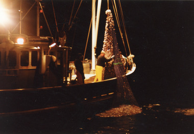 Lakes Entrance Historical Society
Photograph - Southern Hunter, 1991 c
... Colour photograph of fishing net containing four tons of school whiting being hauled aboard a fishing boat, the Southern Hunter off Three Mile Beach, Wilson Promontory Victoria...|Minawie owned by Wayne Smith Fishing Industry Ships and Shipping Ocean Colour photograph of fishing net containing four tons of school whiting being hauled aboard a fishing boat, the Southern Hunter off Three Mile Beach, Wilson Promontory Victoria Photograph Southern Hunter ...Photo taken from Minawie|At this time Southern Hunter owned by Ted Jones, Skipper Darren Jones.|Minawie owned by Wayne SmithColour photograph of fishing net containing four tons of school whiting being hauled aboard a fishing boat, the Southern Hunter off Three Mile Beach, Wilson Promontory Victoriafishing industry, ships and shipping, ocean -
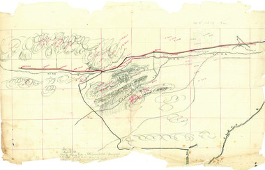 Beechworth Honey Archive
Hand-Drawn Map Centred on Worouly by Frank Lebbell Frost December 1916
... Scale is each red square equals three miles. Drawn with black pen and grey lead on paper. ...Scale is each red square equals three miles. Drawn with black pen and grey lead on paper. ...This is one of the maps drawn by Frank L. Frost while he was beekeeping in North-East Victoria. This particular map may be reference in the "Wooden" Diary on page 10.Hand-drawn map centred on Whorouly and showing other towns, including Oxley, Byrne, Edi and Whitfield. Details the local flowering eucalypts. Scale is each red square equals three miles. Drawn with black pen and grey lead on paper. Grid and other features are marked in red.hand drawn, hand-drawn, map, oxley, byrne, whitfield, edi, frost, beekeeping, beechworth honey -
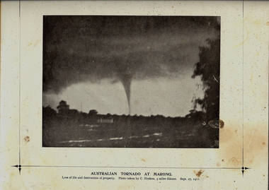
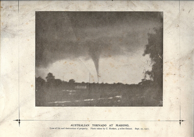 Bendigo Historical Society Inc.
Photograph - TORNADO AT MARONG, 27 Sept 1911
... Photo taken by C Hosken, three miles distant. Sept. 27, 1911. On TR corner 'MP106'. ...Photo taken by C Hosken, three miles distant. Sept. 27, 1911. On TR corner 'MP106'. ...Copy of black and white photograph of tornado at Marong. Dark sky above with funnel to ground. Printed on cream card with printed border. Inscriptions: on front - below image 'Australian Tornado at Marong, loss of life and destruction of property. Photo taken by C Hosken, three miles distant. Sept. 27, 1911. On TR corner 'MP106'. On back - circular stamp 'Royal Historical Society of Victoria, Bendigo Branch', '2nd of 2 copies' hand written in ink.topic, natural disaster -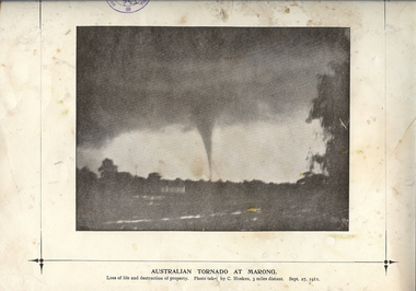
 Bendigo Historical Society Inc.
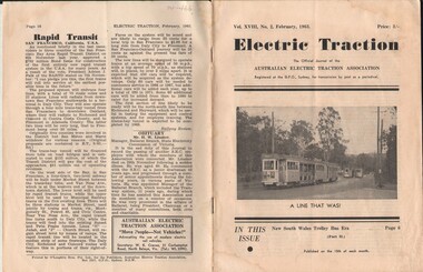
Document - BASIL MILLER COLLECTION: TRAMS - JOURNAL 'ELECTRIC TRACTION', February 1963
... Actually cars 305, 475, 346 and 466 (left to right) are less than three miles from the Brisbane City Hall, being surrounded by parklands and a cemetery at this point along the route, which was the most scenic of the four routes recently closed on trial"....Actually cars 305, 475, 346 and 466 (left to right) are less than three miles from the Brisbane City Hall, being surrounded by parklands and a cemetery at this point along the route, which was the most scenic of the four routes recently closed on trial". ...Journal of Australian Electric Traction Association, Volume XVIII, No. 2, February, 1963, 16 pages. History of document: Part of 'Basil Miller Collection', Also check 1411. Cover picture description: "tall gum trees provide a typical Australian background to four Brisbane tram cars at Toowong Cemetery terminus. Actually cars 305, 475, 346 and 466 (left to right) are less than three miles from the Brisbane City Hall, being surrounded by parklands and a cemetery at this point along the route, which was the most scenic of the four routes recently closed on trial".Pub: Australian Electric Traction Asscn. Printer: O'Loughlin Bros. Pty. Ltd., Sydney, NSWdocument -
 Mission to Seafarers Victoria
Letter - Correspondence, 14/02/1952
... He would have liked to walk past the coffin lying in state at Westminister Hall but the queue was three miles long and it took seven hours to get into the hall....He would have liked to walk past the coffin lying in state at Westminister Hall but the queue was three miles long and it took seven hours to get into the hall. ...Allan describes London following the death of King George VI. He witnessed the Proclamation of the Queen at the Royal Exchange. He writes "The Proclamation was read in four different parts of the city and about a hundred Lifeguards escorted the Royal carriages through the city." And ....."I also saw the procession from Kings Cross station to Westminister Hall when they brought the King back to London." He would have liked to walk past the coffin lying in state at Westminister Hall but the queue was three miles long and it took seven hours to get into the hall.Quinn CollectionA pale blue self-folding letter (0894.a1) headed 37 Elsham Road, London W 14 and dated 14/02/52. Letter is typed using a very small font. The print is faint and difficult to read. It is addressed to Mrs K Hayes, 14 Fitzroy Street, St Kilda, Victoria, Australia. There is no postmark. The return address is Allan Quinn, 37 Elsham Road, London W14.letters-from-abroad, allan quinn, alette andersen, death of king george vi, proclamation of queen elizabeth ii, london 1952 -
 Wodonga & District Historical Society Inc
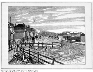
Work on paper - Wodonga From the Railway Line, John Rossi Ashton, 1883
... Between the township and Albury there is a distance of three miles, which in summer has the reputation of being the dustiest three miles in Australia. ...Between the township and Albury there is a distance of three miles, which in summer has the reputation of being the dustiest three miles in Australia. ...This image appeared in the Australasian Sketcher on 2nd July 1883. This issue had several illustrations relating to the meeting of the railways at Albury and Wodonga. The item was accompanied by the following text:- Wodonga consists of two principal streets lying parallel to each other seemingly desirous of outstripping the other in length and the straggling character of its buildings. After carrying on this contest for the length of three quarters of High Street, of which we give a view, bears off the palm. Between the township and Albury there is a distance of three miles, which in summer has the reputation of being the dustiest three miles in Australia. This distance is traversed by omnibuses and cabs, which ply between the two towns, and until the junction of the railways did a good business in carrying all travellers from station to station. The dwellers in Wodonga, who are Victorians to the backbone, complain severely of the disadvantages under which they labour, owing to the border duties, in comparison with their more fortunate neighbours in Albury, but though they grumble they have no intention of giving in, and confidently look forward to the brighter days which they say are in store for Wodonga. In the lower right hand corner are the initials J. R. A. These are the initials of Julian Rossi Ashton (1851-1942). Ashton was born in England and emigrated to Melbourne in 1878 to work as an artist for the Illustrated Australian News. In 1881 he worked at the Australasian Sketcher and in 1883 moved to Sydney to work on the Picturesque Atlas of Australasia and the Bulletin. He became an influential patron and supporter of Australian Art through his roles as trustee of the National Art Gallery of New South Wales. He was awarded the Society of Artists’ medal for distinguished services to Australian art in 1924, appointed as Commander of the Order of the British Empire in 1930, and won the Sydney Sesquicentennial Prize for a watercolour in 1938. Ashton dominated artistic circles in Sydney for over 50 years. He established his own Art School in Sydney and became a teacher and mentor to many now prominent Australian artists. Julian Rossi Ashton died on 27th April 1942 This item is significant because it depicts an early view of Wodonga and was created by a future prominent artist and influential patron and supporter of Australian Art .A print from a Wood Engraving which was published in the Australasian Sketcher 1883. It features a street scene in Wodonga.wodonga town 1883, early wodonga -
![Roadway Scene on the Black Spur / [by] Nicholas Caire, circa 1876](/media/collectors/550653872162f11fb04854aa/items/577759b7d0cdd10a5c1a5d0a/item-media/57775a11d0cdd10a5c1aab42/item-fit-380x285.jpg?cb=6) Kew Historical Society Inc
Kew Historical Society IncPhotograph, Anglo-Australasian Photographic Company, Roadway Scene on the Black Spur, c.1876
... . / The road which is represented in this illustration has lately been constructed by the Government at considerable / expense. It is three miles in length from the base to the summit, some portions of which are very steep. .... / The road which is represented in this illustration has lately been constructed by the Government at considerable / expense. It is three miles in length from the base to the summit, some portions of which are very steep. ...Nicholas Caire was born on Guernsey in the Channel Islands in 1837. He arrived in Adelaide with his parents in about 1860. In 1867, following photographic journeys in Gippsland, he opened a studio in Adelaide. From 1870 to 1876 he lived and worked in Talbot in Central Victoria. In 1876 he purchased T. F. Chuck's studios in the Royal Arcade Melbourne. In 1885, following the introduction of dry plate photography, he began a series of landscape series, which were commercially successful. As a photographer, he travelled extensively through Victoria, photographing places few of his contemporaries had previously seen. He died in 1918. Reference: Jack Cato, 'Caire, Nicholas John (1837–1918)', Australian Dictionary of BiographyAn original, rare photograph from the series 'Views of Victoria: General Series' by the photographer, Nicholas Caire (1837-1918). The series of 60 photographs that comprise the series was issued c. 1876 and reinforced a neo-Romantic view of the Australian landscape to which a growing nationalist movement would respond. Nicholas Caire was active as a photographer in Australia from 1858 until his death in 1918. His vision of the Australian bush and pioneer life had a counterpart in the works of Henry Lawson and other nationalist poets, authors and painters.Albumen silver photograph mounted on boardprinted in ink on support l.c.: ROADWAY SCENE ON THE BLACK SPUR. / COPYRIGHT REGISTERED printed in ink (vertically) on support reverse u.c.l.: J.W. FORBES, Agent, printed in ink (vertically) on support reverse c.l.: ANGLO-AUSTRALASIAN PHOTOGRAPHIC COMPANY, MELBOURNE. printed in ink (vertically) on support reverse c.: VIEWS OF VICTORIA. / (GENERAL SERIES.) / No. 18. / ROADWAY SCENE ON THE BLACK SPUR. / The road which is represented in this illustration has lately been constructed by the Government at considerable / expense. It is three miles in length from the base to the summit, some portions of which are very steep. Mails / are conveyed by Cobb & Co.'s Coaches to Marysville and Woodspoint via this route daily. The scenery on the Black / Spur, and beyond as far as Myrtle Creek, is exceedinly picturesque. printed in ink (vertically) on support reverse l.c.l.: 10 Temple Court, Collins Street West.nicholas caire (1837-1918), landscape photography, black spur - victoria -
 Federation University Historical Collection
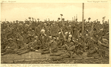
Postcard - Sepia, The "Fighting Fifth" after the Battle of St Eloi, c1916
... . “… the British had been patiently tunnelling since August (1915) at nearby St Eloi, about three miles south of Ypres, and adjacent to the Canadian trenches. .... “… the British had been patiently tunnelling since August (1915) at nearby St Eloi, about three miles south of Ypres, and adjacent to the Canadian trenches. ...Holmes Family WW1 memorabilia. 06 Apr 1916 - The Battle of St Eloi Craters, Canadian Expeditionary Forces Major Operation. “… the British had been patiently tunnelling since August (1915) at nearby St Eloi, about three miles south of Ypres, and adjacent to the Canadian trenches. Throughout the winter, the tunnelling crept ever closer to a dominant German-held feature dubbed “The Mound.” When the tunnels were completed in early March, tons of explosives were emplaced in six locations and on March 27, 1916, at 4:14 a.m. the charges were set off. Two German companies were wiped out and large sections of the German trenches were destroyed, but the British 9th Brigade’s attack faltered and became a bloody close-quarters slugging match, with the last bomb crater captured only on April 3.” (Zuehlke, Mark. Daniel, C. Stuart. The Canadian Military Atlas. The Nation’s Battlefields from the French and Indian Wars to Kosovo. Stoddart Publishing Co. Limited. Toronto. 2001 p. 125)A number of World War One soldiers, members of the Northumberland Fusiliers celebrate after the battle of St Eloi. Some or wear tin helmuts.The "Fighting Fifth" (Northumberland Fusiliers) after the battle of St Eloi"chatham-holmes family collection, fighting fifth, northumberland fusiliers, tunneling, explosion, crater, world war one, postcard -
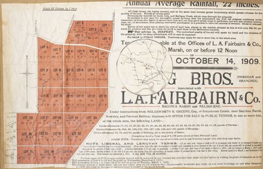 Bacchus Marsh & District Historical Society
Map, Greystones Estate Land Sale 1909
... And situated only six miles from that prosperous township, two miles from Rowsley, and three miles from Parwan, all Railway towns, connected with the Estate by metal roads." ...And situated only six miles from that prosperous township, two miles from Rowsley, and three miles from Parwan, all Railway towns, connected with the Estate by metal roads." ...This map was produced sometime around mid 1909 to advertise portions of land from the Greystones Estate for sale by public tender. The selling agents were Young Brothers of Horsham and L.A. Fairbairn of Bacchus Marsh and Melbourne. The seller was Molesworth R. Greene who was a pioneer pastoralist in the Bacchus Marsh area and had also acquired other properties in Victoria and interstate. Molesworth Greene died in 1916 so this sale came towards the end of his life. A total of 4,176 acres was offered for sale in multiple lots. Successful tenderers could buy single or multiple lots. The results of the sale were reported in the Bacchus Marsh Express newspaper on the 16th October 1909, page 3. At the sale a total of 3, 420 acres was sold. A single page paper map showing portions of land for sale from the Greystones Estate near Bacchus Marsh. The map includes extensive details about the property, number of allotments for sale, terms and conditions of the sale and prices. The map includes an inserted reference map showing the location of the property in relation to Melbourne, Geelong, Ballarat and Castlemaine. The top of the map appears to be missing resulting in some loss of the text. The sale notice in the Bacchus Marsh Express of 10 July, 1909, page 3, column 1 appears to duplicate the text overall in the auction plan. Based on this the missing text is likely to be: "Important Subdivisional Sale 'Of Portion of One of the Best and Most Favourably known Estates IN THE RENOWNED BACCHUS MARSH DISTRICT. And situated only six miles from that prosperous township, two miles from Rowsley, and three miles from Parwan, all Railway towns, connected with the Estate by metal roads." Scale: 20 chains to 1 inch The map is pasted into a bound volume containing 76 maps or plans in total. bacchus marsh victoria maps, land sales, land sales bacchus marsh, greystones estate bacchus marsh, molesworth r. green 1827-1916, land sales rowsley -
 Rutherglen Historical Society
Photograph - Image, 1970s
... Smith and Banks began growing vines at ‘Sunday Creek’ closer to Wahgunyah than the present All Saints Estate winery, before relocating to build the 'All Saints castle' just three miles north of Wahgunyah, in 1864. The partners took up 100 acres and proceeded with planting vines in earnest whilst also constructing pise cellars made from the estate soil. ...Smith and Banks began growing vines at ‘Sunday Creek’ closer to Wahgunyah than the present All Saints Estate winery, before relocating to build the 'All Saints castle' just three miles north of Wahgunyah, in 1864. The partners took up 100 acres and proceeded with planting vines in earnest whilst also constructing pise cellars made from the estate soil. ...All Saints Estate is a family owned winery established in 1864 and located on the banks of the Murray River in Wahgunyah, North East Victoria. Original owners George Sutherland Smith, and John Banks, arrived from Caithness, Scotland in 1852. They were just 23 and 20 years of age. Choosing to settle in the Wahgunyah area, they used their training as engineers from the Edinburgh Railway Institute to build a bridge over the Edwards River at Deniliquin. They were also involved in the construction of several buildings in Beechworth including the Presbyterian Church, part of the Gaol and the original hospital of which the granite facade still remains today. Smith and Banks began growing vines at ‘Sunday Creek’ closer to Wahgunyah than the present All Saints Estate winery, before relocating to build the 'All Saints castle' just three miles north of Wahgunyah, in 1864. The partners took up 100 acres and proceeded with planting vines in earnest whilst also constructing pise cellars made from the estate soil. The All Saints Estate castle was based on the design of ‘The Castle of Mey’, including turrets and a tower. The castle was constructed mainly of handmade bricks that were fired in the All Saints Estate Brick Kiln (classified on the Victorian Heritage Register) on the property. However, only the battement parapets of the lower wall and a turrets were copied, not the main castle style. The Castle of Mey, most recently owned by the late Queen Mother, was where George Sutherland-Smiths’ father was a carpenter and joiner.Black and white photograph showing a view, up a road between the Elm Tree entry drive of All Saints Winery wineries, north east victoria, wine industry, all saints winery, rutherglen, wahgunyah, winemaking, castle, winery -
 Rutherglen Historical Society
Image, 1970s
... Smith and Banks began growing vines at ‘Sunday Creek’ closer to Wahgunyah than the present All Saints Estate winery, before relocating to build the 'All Saints castle' just three miles north of Wahgunyah, in 1864. The partners took up 100 acres and proceeded with planting vines in earnest whilst also constructing pise cellars made from the estate soil. ...Smith and Banks began growing vines at ‘Sunday Creek’ closer to Wahgunyah than the present All Saints Estate winery, before relocating to build the 'All Saints castle' just three miles north of Wahgunyah, in 1864. The partners took up 100 acres and proceeded with planting vines in earnest whilst also constructing pise cellars made from the estate soil. ...All Saints Estate is a family owned winery established in 1864 and located on the banks of the Murray River in Wahgunyah, North East Victoria. Original owners George Sutherland Smith, and John Banks, arrived from Caithness, Scotland in 1852. They were just 23 and 20 years of age. Choosing to settle in the Wahgunyah area, they used their training as engineers from the Edinburgh Railway Institute to build a bridge over the Edwards River at Deniliquin. They were also involved in the construction of several buildings in Beechworth including the Presbyterian Church, part of the Gaol and the original hospital of which the granite facade still remains today. Smith and Banks began growing vines at ‘Sunday Creek’ closer to Wahgunyah than the present All Saints Estate winery, before relocating to build the 'All Saints castle' just three miles north of Wahgunyah, in 1864. The partners took up 100 acres and proceeded with planting vines in earnest whilst also constructing pise cellars made from the estate soil. The All Saints Estate castle was based on the design of ‘The Castle of Mey’, including turrets and a tower. The castle was constructed mainly of handmade bricks that were fired in the All Saints Estate Brick Kiln (classified on the Victorian Heritage Register) on the property. However, only the battement parapets of the lower wall and a turrets were copied, not the main castle style. The Castle of Mey, most recently owned by the late Queen Mother, was where George Sutherland-Smiths’ father was a carpenter and joiner.Black and white photograph showing a view, up a road between the Elm Tree entry drive of All Saints Winery On back of photo: "250% [upper case D in small circle] All Saints"wineries, north east victoria, wine industry, all saints winery, rutherglen, wahgunyah, winemaking, castle, winery -
 Ringwood and District Historical Society
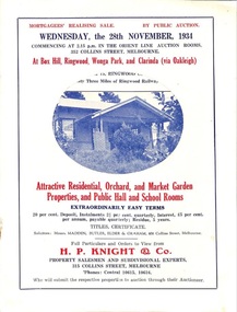
Flyer, Stillwell & Stephens Pty. Ltd, Brochure - Multiple Properties for Public Auction at Box Hill, Ringwood, Wonga Park and Clarinda - 28th November, 1934
... Wonga Park via Ringwood - "Holme Bush" off Warrandyte Road, Part of Lots 14 and 15, Ringwood Orchard Estate, approximatgely three miles (north) of Ringwood Railway Station - 64 Acres. 2. 17 Bishop Street, Box Hill - timber residence. 3. ...Wonga Park via Ringwood - "Holme Bush" off Warrandyte Road, Part of Lots 14 and 15, Ringwood Orchard Estate, approximatgely three miles (north) of Ringwood Railway Station - 64 Acres. 2. 17 Bishop Street, Box Hill - timber residence. 3. ...Seven-page brochure advertising Mortgagees' Realising Sale by Public Auction on Wednesday, 28th November, 1934 for properties at Box Hill, Ringwood, Wonga Park, and Clarinda (via Oakleigh), including photographs, property descriptions, and terms of sale.Auction Commencing at 2.15 p.m. in the Orient Line Auction Rooms, 352 Collins Street, Melbourne. Solicitors: Messrs. Madden, Butler, Elder & Graham, 406 Collins Street, Melbourne. (Agents) H.P. Knight & Co. Property Salesmen and Subidivisional Experts, 315 Collins Street, Melbourne, 'Phones: Central 10615, 10616. Attractive Residential, Orchard, and Market Garden Properties, and Public Hall and School Rooms. 1. Wonga Park via Ringwood - "Holme Bush" off Warrandyte Road, Part of Lots 14 and 15, Ringwood Orchard Estate, approximatgely three miles (north) of Ringwood Railway Station - 64 Acres. 2. 17 Bishop Street, Box Hill - timber residence. 3. Greenwood Avenue, Ringwood - On East Side, 150 feet 3 inches South of Bedford Road - timber attic residence. 4. Ringwood - Wantirna Road, South-east corner of Canterbury Road - Orchard Property of approx. 11-1/2 Acres. 5. Box Hill - Whitehorse Road, South-east corner of Linsley Street - Timber building utilised as a Public Hall and Private School. 6. Clarinda vic Oakleigh, Talbot Crescent, off Centre Road - Home on 10 acres of land. -
 Greensborough Historical Society
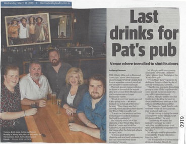
Newspaper Clipping, Diamond Valley Leader, Last drinks for Pat's pub, 13/03/2019
... The Windy Mile pub in Diamond Creek has 'never been the same" since teenager Patrick Cronin died from a senseless coward punch at the bar almost three years ago.The Windy Mile will serve its last drink on Sunday, March 31 2019....Greensborough Historical Society 34A Glenauburn Road Lower Plenty Lower Plenty melbourne The Windy Mile pub in Diamond Creek has 'never been the same" since teenager Patrick Cronin died from a senseless coward punch at the bar almost three years ago.The Windy Mile will serve its last drink on Sunday, March 31 2019. windy mile diamond creek patrick cronin Cronin family News article 1 page, black text. ...The Windy Mile pub in Diamond Creek has 'never been the same" since teenager Patrick Cronin died from a senseless coward punch at the bar almost three years ago.The Windy Mile will serve its last drink on Sunday, March 31 2019.News article 1 page, black text.windy mile, diamond creek, patrick cronin, cronin family -
 Ringwood and District Historical Society
Book, David Mitchell at Anderson's Creek Goldfield, 1870-1887 - Who Dug the Pound Bend Tunnel?, 2004
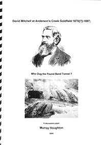
... She then continues with the bizarre statement that "he employed gangs of Chinese to work three miles of river bed for gold". Neither of these respective excerpts indicate evidence of having been directly referenced from a legitimate original source, from which either author's contained comments might be authenticated. ...She then continues with the bizarre statement that "he employed gangs of Chinese to work three miles of river bed for gold". Neither of these respective excerpts indicate evidence of having been directly referenced from a legitimate original source, from which either author's contained comments might be authenticated. ...Suggested reading - David Mitchell, A Forfar Man - Pamela Vestey. (National Library of Australia ISBN No. 0646104977 Second edition - 1996.A discussion paper by Murray Houghton, Warrandyte Historical Society, on the excavation of Pound Bend tunnel and examination of information sources suggesting David Mitchell's association with gold mining at Warrandyte." ... Just what then was Mitchell's actual association with mining in the Anderson's Creek goldfield? As an initial means to determining this, a number of biographies devoted to the man's lifetime achievements have been consulted. Some two of these were found to contain rather brief references to his involvement at Warrandyte. In the 1992 booklet entitled "David Mitchell a Forfar Man" written by a Mitchell family member, viz., Pamela, Lady Vestey, of Coombe Cottage, there is included a passge which commences "Another of David Mitchell's early interests was gold mining". This is appended by the bald statement "In 1870 he formed the Evelyn Tunnel Gold-Mining Company with a capital of £16,000." The other account of a Mitchell involvement with an unnamed Warrandyte company is contained in Joan Campbell's 1974 biographical article entitled, "Mitchell, David (1829- 1916) builder, contractor and businessman, etc.", in Volume 5 of the "Australian Dictionary of Biogaraphy". Campbell mentions that "In 1890 (sic) Mitchell formed a company to mine a channel and tunnel on the Yarra River at Pound Bend, Warrandyte," i.e., at a period some 18 or so years after it is known that the Evelyn Tunnel Gold-Mining Company had actually ceased operations. She then continues with the bizarre statement that "he employed gangs of Chinese to work three miles of river bed for gold". Neither of these respective excerpts indicate evidence of having been directly referenced from a legitimate original source, from which either author's contained comments might be authenticated. For any historian with an enquiring mind these statements demand further clarification. ..." - Murray Houghton -
 Queenscliffe Maritime Museum
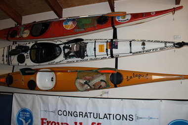
Vehicle - Kayak
... To overcome the three 100 mile plus long sections of cliffs, Paul used Nodoz tablets to stay awake and Lomotil to keep his bowels dormant during these overnight paddles. ...To overcome the three 100 mile plus long sections of cliffs, Paul used Nodoz tablets to stay awake and Lomotil to keep his bowels dormant during these overnight paddles. ...Paul Caffyn undertook perhaps the ultimate kayak circumnavigation, a 9,420mile journey around Australia in 1981/2 which took 360 days to complete. ‘The Dreamtime Voyage’ is his account of this odyssey which is acknowledged as one of the most remarkable journeys ever undertaken by kayak. Paul had to contend with a tropical cyclone which nearly swept him off a small offshore islet in the Coral Sea, raging surf, tiger sharks which frequently bumped into the kayak in the Gulf of Carpentaria, crocodiles, sea snakes and three sections of sheer limestone cliffs. To overcome the three 100 mile plus long sections of cliffs, Paul used Nodoz tablets to stay awake and Lomotil to keep his bowels dormant during these overnight paddles. The longest stint along the awesome Zuytdorp Cliffs in Western Australia, took 34 hours of continuous paddling.Sea kayak used by Paul Caffyn to circumnavigate Australia in 1981-82. First sea kayak to voyage around Australia.Yellow fibreglass kayak"Lalaguli" various other markingssea kayak, paul caffyn, lalagule -
Ringwood and District Historical Society
Envelope, Commonwealth Meteorology, Rainfall records kept by the Mile Family Ringwood (official record books). 1915-1958. History or Rainfall Observation at Ringwood 1969, 1915-1958
... Rainfall records kept by the Miles family; Three record books, rain register - Commonwealth Meteorology 1915-1925, 1937-1947, 1948-1958; History of Rainfall Observation at Ringwood: 13 February 1969; See also re rainfall collection 3466 2-3-3 Box 2; See also re rainfall collection 3993 2-7-05 Envelope +Additional Keywords: Temple Miles, A...Ringwood and District Historical Society 125A Warrandyte Road Ringwood North melbourne Rainfall records kept by the Miles family; Three record books, rain register - Commonwealth Meteorology 1915-1925, 1937-1947, 1948-1958; History of Rainfall Observation at Ringwood: 13 February 1969; See also re rainfall collection 3466 2-3-3 Box 2; See also re rainfall collection 3993 2-7-05 Envelope +Additional Keywords: Temple Miles, A Rainfall records kept by the Mile Family Ringwood (official record books). 1915-1958. ...Rainfall records kept by the Miles family; Three record books, rain register - Commonwealth Meteorology 1915-1925, 1937-1947, 1948-1958; History of Rainfall Observation at Ringwood: 13 February 1969; See also re rainfall collection 3466 2-3-3 Box 2; See also re rainfall collection 3993 2-7-05 Envelope +Additional Keywords: Temple Miles, A