Showing 124 items matching "timber residence"
-
 Flagstaff Hill Maritime Museum and Village
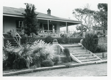
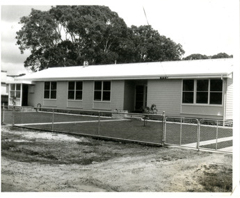
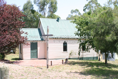
Photograph - Historical, Flagstaff Hill, Harbourmaster’s Quarters, 1970s
... ...timber residence...Photograph shows the cream timber cottage, Harbourmaster’s quarters to the east of the lighthouse complex at Flagstaff Hill, Warrnambool. On the left of the red roofed residence are iron buildings used, at the time, by the Lands Department. ...Flagstaff Hill Flagstaff Hill Maritime Museum and Village Warrnambool Maritime Museum Maritime Village Great Ocean Road Shipwreck Coast 1970s photograph Flagstaff Hill site John Lindsay cannon emplacement residence wooden residence timber residence iron huts Lands Department light keeper Label on the back: "WOODEN RESIDENCE TO THE EAST OF THE PROPERTY / The gun emplacements are immediately behind, and the iron huts to the left rear of the residence are used by the Lands Department who plan to vacate, for other premises." ...The photograph shows a cottage, Harbourmaster’s quarters that still stands on the east of the Lady Bay Lighthouse and Historic Precinct at Flagstaff Hill in Warrnambool. The name was changed to the Lighthouse Lodge, and today guests can stay at the property. This photograph, a print, is one of a set of five that show the site of Flagstaff Hill. It is presumed to have been taken by John Lindsay, Founding Director of Flagstaff Hill Maritime Museum and Village. One of the photographs in the set has the pencil inscription "Photo J Lindsay". It was taken in the early 1970s during the initial stages of the development of Flagstaff Hill as a Museum and Maritime Village. The photographs belonged to the donor's grandparents, who lived in the Warrnambool district of Allansford/Naringal. The photograph is a record of the site and surrounds of Flagstaff Hill Maritime Museum and Village before its development and opening in 1975. It shows the cottage on the east of the Lighthouse Complex,. The building is now known as Lighthouse Lodge. The photograph is significant for recording the location and condition of the residence on the Hill.Coloured photograph, glassy print, one of a set of five. Photograph shows the cream timber cottage, Harbourmaster’s quarters to the east of the lighthouse complex at Flagstaff Hill, Warrnambool. On the left of the red roofed residence are iron buildings used, at the time, by the Lands Department. The photograph's paper has the printer's watermark on the back. The early 1970s photograph is presumed to have been by John Lindsay, Warrnambool.Label on the back: "WOODEN RESIDENCE TO THE EAST OF THE PROPERTY / The gun emplacements are immediately behind, and the iron huts to the left rear of the residence are used by the Lands Department who plan to vacate, for other premises."flagstaff hill, flagstaff hill maritime museum and village, warrnambool, maritime museum, maritime village, great ocean road, shipwreck coast, 1970s, photograph, flagstaff hill site, john lindsay, cannon emplacement, residence, wooden residence, timber residence, iron huts, lands department, light keeper -
 Lakes Entrance Historical Society
Photograph - Historic House, 30 Church Street. Lakes Entrance 1999
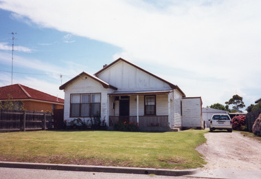
... Colour photograph of a timber residence with hipped roof situated at 30 Church Street. ...Houses Heritage Study Colour photograph of a timber residence with hipped roof situated at 30 Church Street. ...Some early residents : Pa & Ma Powell, Race Mitchelson. Still occupied 2012.|Also One other colour photograph similar.Colour photograph of a timber residence with hipped roof situated at 30 Church Street. Front door has window lights beside and above door. Sash windows. Lakes Entrance Victoriahouses, heritage study -
 Lakes Entrance Historical Society
Photograph - Historic House, Clovelly, at 5 Essington Close, Metung Victoria, 1999
... Colour photograph of a substantial timber residence, Clovelly, at 5 Essington Close, corrugated iron gable roof, gable projection on side has bay window, external chimneys. ...Historic Houses Heritage Study Colour photograph of a substantial timber residence, Clovelly, at 5 Essington Close, corrugated iron gable roof, gable projection on side has bay window, external chimneys. ...Built by William King, grandson of Governor Phillip King. Clovelly, was the home of Alfred Howitt from 1901, then became the property of his daughter Annie Whittakers of Tubbut and Traralgon, then grand-daughter Maude Anderson McMillan. After her death auctioned 1955.Colour photograph of a substantial timber residence, Clovelly, at 5 Essington Close, corrugated iron gable roof, gable projection on side has bay window, external chimneys. Metung Victoriahistoric houses, heritage study -
 Ringwood and District Historical Society
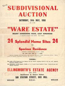
Flyer, Subdivisional Auction Sale Brochure, Ware Estate, East Ringwood, Vic. - 1958
... Subdivision includes Mount Dandenong Road, Ware Crescent, Davey Drive, and Grey Road (later Grey Street). Timber residence included in the subdivision was formerly Ware Kindergarten Holiday Home. ...Ringwood and District Historical Society 125A Warrandyte Road Ringwood North melbourne Subdivision includes Mount Dandenong Road, Ware Crescent, Davey Drive, and Grey Road (later Grey Street). Timber residence included in the subdivision was formerly Ware Kindergarten Holiday Home. ...Folded double-sided advertisement for auction of 24 home sites and existing residence on Saturday, 24th May, 1958, including locality map, subdivision layout, terms of sale, and summary of local facilities and services. Additional plan of lots 28-33 dated 26/10/60 by Licensed Surveyor for Kirkpatrick & Webber, 225 Maroondah Highway Ringwood headed Plan of Subdivision of part of Crown Allotment 26A Parish of Ringwood.Subdivision includes Mount Dandenong Road, Ware Crescent, Davey Drive, and Grey Road (later Grey Street). Timber residence included in the subdivision was formerly Ware Kindergarten Holiday Home. (Agent) Ellingworth's Estate Agency, 580 Station Street, Box Hill - (Phone) WX1228. -
 Lakes Entrance Historical Society
Photograph - Housing Mill Point Road, Toorloo Arm Victoria, 1991
... Black and white photograph of a timber residence with corrugated iron roof, six wide steps leading from shaded veranda, native plant garden in narrow terrace with sleeper steps leading down to mowed lawn. ...Date made September 1991 Houses Timber Industry Heritage Study Black and white photograph of a timber residence with corrugated iron roof, six wide steps leading from shaded veranda, native plant garden in narrow terrace with sleeper steps leading down to mowed lawn. ...Date made September 1991Black and white photograph of a timber residence with corrugated iron roof, six wide steps leading from shaded veranda, native plant garden in narrow terrace with sleeper steps leading down to mowed lawn. Situated at Mill Point Road, Toorloo Arm Victoriahouses, timber industry, heritage study -
 Lakes Entrance Historical Society
Photograph - Historic House, 3 Phillips Street. Lakes Entrance Victoria, 2000
... Colour photograph of a timber residence at 3 Phillips Street. Gable roof, fibro cement section under gables. ...Houses Heritage Study Colour photograph of a timber residence at 3 Phillips Street. Gable roof, fibro cement section under gables. ...House built on Rigby Island by Mitchelson around 1915, relocated to corner of Lake Street and Barkes Avenue around 1920, then to Phillips Street 1962. Front window altered, veranda frieze removed, side extension of veranda removed.Colour photograph of a timber residence at 3 Phillips Street. Gable roof, fibro cement section under gables. Front door has fanlight above, widow light beside door filled in. Barge board of gables typical of dwellings built by Leo Mitchelson, Lakes Entrance Victoriahouses, heritage study -
 Lakes Entrance Historical Society
Photograph - Post Office/Roadknight house/Johnsonviille, 1997
... A substantial timber residence painted white, hipped roof, bullnose veranda on front and east side. ...A substantial timber residence painted white, hipped roof, bullnose veranda on front and east side. ...This home and Post Office was run by Mrs James Roadknight nee Annie SmithColour photograph showing aspect of the former Johnsonville Post Office and residence. A substantial timber residence painted white, hipped roof, bullnose veranda on front and east side. The Post Office was originally detached, later moved to south east corner of house. Situated on Princes Highway western end of Johnsonville Victoria. Plus two other photos (02510.8 and 02510.8a) houses, heritage study, postal services -
 Sunshine and District Historical Society Incorporated
Photograph - H Harrison Shop & Post Office Main Road West St Albans
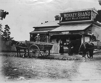
... A Black and White photograph featuring a dirt road basalt blue stone used as road side kerbs x 2 horse drawn carts for transporting timber or metal sheeting wooden timber residence home with adjoining business wiith a white picket fence 2 ladies dressed in long black frocks x1 young female child with 2 gentlemen on carts with horses that say H Harrison Business sign says H Harrison PostTelegraph Office large sign says Monkey Brand Wont Wash Clothes and some trees on left hand side of photograph...Albans Harry Harrsion A Black and White photograph featuring a dirt road basalt blue stone used as road side kerbs x 2 horse drawn carts for transporting timber or metal sheeting wooden timber residence home with adjoining business wiith a white picket fence 2 ladies dressed in long black frocks x1 young female child with 2 gentlemen on carts with horses that say H Harrison Business sign says H Harrison PostTelegraph Office large sign says Monkey Brand Wont Wash Clothes and some trees on left hand side of photograph Photograph H Harrison Shop & Post Office Main Road West St Albans ...st. albans, harry harrsion -
 Marysville & District Historical Society
Photograph (Item) - Colour photograph, 1996
... The house is a timber clad double storey residence....The house is a timber clad double storey residence. Photograph Colour photograph ...A colour photograph of a house in Keppels Court in Marysville in Victoria.A colour photograph of a house in Keppels Court in Marysville in Victoria. This house, along with most other buildings in Marysville, was destroyed in the 2009 Black Saturday bushfires.keppels court, marysville, victoria, photograph, 2009 black saturday bushfires -
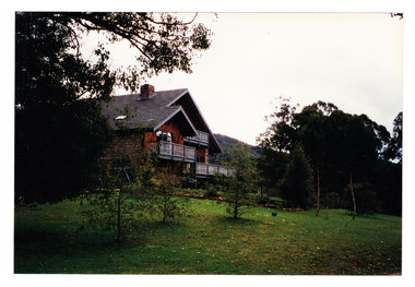
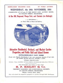 Ringwood and District Historical Society
Flyer, Stillwell & Stephens Pty. Ltd, Brochure - Multiple Properties for Public Auction at Box Hill, Ringwood, Wonga Park and Clarinda - 28th November, 1934
... Wonga Park via Ringwood - "Holme Bush" off Warrandyte Road, Part of Lots 14 and 15, Ringwood Orchard Estate, approximatgely three miles (north) of Ringwood Railway Station - 64 Acres. 2. 17 Bishop Street, Box Hill - timber residence. 3. Greenwood Avenue, Ringwood - On East Side, 150 feet 3 inches South of Bedford Road - timber attic residence. 4. ...Wonga Park via Ringwood - "Holme Bush" off Warrandyte Road, Part of Lots 14 and 15, Ringwood Orchard Estate, approximatgely three miles (north) of Ringwood Railway Station - 64 Acres. 2. 17 Bishop Street, Box Hill - timber residence. 3. Greenwood Avenue, Ringwood - On East Side, 150 feet 3 inches South of Bedford Road - timber attic residence. 4. ...Seven-page brochure advertising Mortgagees' Realising Sale by Public Auction on Wednesday, 28th November, 1934 for properties at Box Hill, Ringwood, Wonga Park, and Clarinda (via Oakleigh), including photographs, property descriptions, and terms of sale.Auction Commencing at 2.15 p.m. in the Orient Line Auction Rooms, 352 Collins Street, Melbourne. Solicitors: Messrs. Madden, Butler, Elder & Graham, 406 Collins Street, Melbourne. (Agents) H.P. Knight & Co. Property Salesmen and Subidivisional Experts, 315 Collins Street, Melbourne, 'Phones: Central 10615, 10616. Attractive Residential, Orchard, and Market Garden Properties, and Public Hall and School Rooms. 1. Wonga Park via Ringwood - "Holme Bush" off Warrandyte Road, Part of Lots 14 and 15, Ringwood Orchard Estate, approximatgely three miles (north) of Ringwood Railway Station - 64 Acres. 2. 17 Bishop Street, Box Hill - timber residence. 3. Greenwood Avenue, Ringwood - On East Side, 150 feet 3 inches South of Bedford Road - timber attic residence. 4. Ringwood - Wantirna Road, South-east corner of Canterbury Road - Orchard Property of approx. 11-1/2 Acres. 5. Box Hill - Whitehorse Road, South-east corner of Linsley Street - Timber building utilised as a Public Hall and Private School. 6. Clarinda vic Oakleigh, Talbot Crescent, off Centre Road - Home on 10 acres of land. -
 Ringwood and District Historical Society
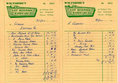
Document - Manila Folder, Collection of personal documents for Mr Emil Goddard, 15 Eastfield Road, Ringwood East, Victoria, 1947-1953
... Specifications of work to be done and materials to be used in the erection of a timber residence at 15 Eastfield Road, Ringwood East, for E.K. ...Specifications of work to be done and materials to be used in the erection of a timber residence at 15 Eastfield Road, Ringwood East, for E.K. ...Correspondence between Mr Goddard and Repatriation Department regarding War Pension entitlements. Specifications of work to be done and materials to be used in the erection of a timber residence at 15 Eastfield Road, Ringwood East, for E.K. Goddard. Contract of Sale of Land at Lots 55 & 56 on P/S No.10492, part of Crown allotments 27 and 28,B, Parish of Ringwood, County of Mornington. Miscellaneous receipts from 1947-1953 including Hire Purchase Agreement for Hillman Minx car. Also includes letter from Presbyterian Ladies' College referring to 1953 term 1 fee of £18.0.3 for Margaret Goddard Receipts from Wiltshire's East Ringwood Hardware, 98 Railway Avenue, East Ringwood, Phone 87-6092, 8/7/1962. -
 Bendigo Historical Society Inc.
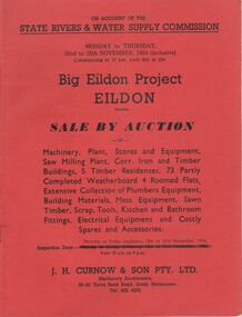
Document - IAN DYETT COLLECTION: AUCTION CATALOGUE - BIG EILDON PROJECT
... Iron and timber buildings, 5 timber residences, 73 partly completed weatherboard 4 roomed flats, extensive collection of plumbers equipment, building materials, mess equipment, sawn timber, scrap, tools, kitchen and bathroom fittings, electrical equipment and costly spares and accessories. ...Iron and timber buildings, 5 timber residences, 73 partly completed weatherboard 4 roomed flats, extensive collection of plumbers equipment, building materials, mess equipment, sawn timber, scrap, tools, kitchen and bathroom fittings, electrical equipment and costly spares and accessories. ...Two red covered auction catalogues for an auction on account of the State Rivers & Water Supply Commission on the 22nd to 25th November, 1954 (inclusive) held at the Big Eildon Project, Eildon, Victoria. Lots sold include Machinery, plant, stores and equipment, Saw Milling Plant, corr. Iron and timber buildings, 5 timber residences, 73 partly completed weatherboard 4 roomed flats, extensive collection of plumbers equipment, building materials, mess equipment, sawn timber, scrap, tools, kitchen and bathroom fittings, electrical equipment and costly spares and accessories. Catalogue has a Locality Plan of Eildon, photo, locality and description of the Eildon Sawmill. Photos of completed houses, incomplete flats and plan showing layout of flat unit, photo of flat block (Completed). Also Building Kits - Designs and Component Lists.business, auctioneers, j h curnow & son pty ltd, ian dyett collection - auction catalogue - big eildon project, state rivers & water supply commission, j h curnow & son pty ltd, eildon sawmill, prahran telegraph printing co -
 Victoria Police Museum
Police Stations (Apsley)
... The station moved several times until the mid 1960s when a timber residence was moved onto land adjacent to the Post Office. ...The station moved several times until the mid 1960s when a timber residence was moved onto land adjacent to the Post Office. ...Apsley is a small town in Victoria, Australia. It is on the Wimmera Highway, in the Shire of West Wimmera, 420 kilometres north-west of Melbourne, and 7 kilometres east of the South Australian border. Apsley Police Station opened on 29th November 1884 and was originally located in Wallace Street. It was staffed by one Foot Constable (motor cycle). The building was described, in 1930, as a four-roomed dwelling with an iron roof, set on a quarter of an acre of land. There was a bathroom, a WC, wash-house and a garage. An office adjoined the house and there was also a lockup. The station moved several times until the mid 1960s when a timber residence was moved onto land adjacent to the Post Office. The building is believed to have been transported from the Stawell area. Apsley is one of a handful of one-man police stations in Victoria and its current location, including residence, is at 19 Splatt Street. Apsley was in the Western District when it opened, then in "L" (Wimmera) District from January 1948 and "M" (Highlands/Wimmera) District from March 1990. 4 black & white photos, 1965 3 colour photos, 1987police stations; apsley police station -
 Marysville & District Historical Society
Photograph (Item) - Colour photograph, 1996
... One house is a timber clad double storey residence and the other is a Dutch gable style house....One house is a timber clad double storey residence and the other is a Dutch gable style house. ...A colour photograph of two houses in Keppels Court in Marysville in Victoria.A colour photograph of two houses in Keppels Court in Marysville in Victoria. These houses, along with most other buildings in Marysville, was destroyed in the 2009 Black Saturday bushfires.keppels court, marysville, victoria, photograph, 2009 black saturday bushfires -
 Bendigo Historical Society Inc.
Photograph - NEW CHUM GULLY C 1875, C 1875
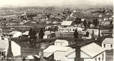
... Back and white photograph: panorama showing timber and brick residences, hotel, church ? Mines with poppet heads and chimneys in background. ...History House 11 Mackenzie Street Bendigo goldfields PLACE Landscape view new chum gully Bendigo cityscape Sandhurst panorama mining town Caire Back and white photograph: panorama showing timber and brick residences, hotel, church ? Mines with poppet heads and chimneys in background. ...Back and white photograph: panorama showing timber and brick residences, hotel, church ? Mines with poppet heads and chimneys in background. An image on building at centre ' Cleary's Honeysuckle Hotel' Ken Arnold captions this image ' New Chum Gully from Specimen Hill C 1875, photographer Caire 'Caireplace, landscape view, new chum gully, bendigo, cityscape, sandhurst, panorama, mining town -
 Bendigo Historical Society Inc.
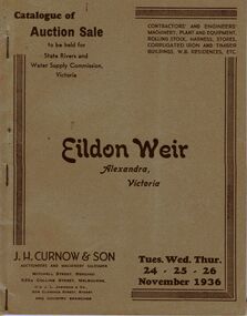
Document - IAN DYETT COLLECTION: AUCTION CATALOGUE - EILDON WEIR
... For sale was Contractors' and Engineers' Machinery, Plant and Equipment, Rolling Stock, Harness, Stores, Corrugated Iron and Timber Buildings, W.B. Residences, etc. Contains a black and white photo of the Eildon Weir and the Administrative Quarters, Lot No. 1306....For sale was Contractors' and Engineers' Machinery, Plant and Equipment, Rolling Stock, Harness, Stores, Corrugated Iron and Timber Buildings, W.B. Residences, etc. Contains a black and white photo of the Eildon Weir and the Administrative Quarters, Lot No. 1306. ...Grey covered auction catalogue with brown printing for a sale on the 24th, 25th and 26th November 1936 for the State Rivers and Water Supply Commission held at Eildon Weir, Alexandra, Victoria. For sale was Contractors' and Engineers' Machinery, Plant and Equipment, Rolling Stock, Harness, Stores, Corrugated Iron and Timber Buildings, W.B. Residences, etc. Contains a black and white photo of the Eildon Weir and the Administrative Quarters, Lot No. 1306.business, auctioneers, j h curnow & son pty ltd, ian dyett collection - auction catalogue - eildon weir, state rivers and water supply commission, j h curnow & son, j l jamieson, bolton bros pty ltd -
 Bendigo Historical Society Inc.
Document - HERITAGE REPORT: FORMER POLICE STATION AND QUARTERS: CALIFORNIA GULLY
... It is the former police station and quarters, former timber stables and timber cottage residence demolished and horse paddock on separate title. ...It is the former police station and quarters, former timber stables and timber cottage residence demolished and horse paddock on separate title. ...Seventeen page Heritage Place Report on the Former California Gully Police Station at 15 Thorpe Street, California Gully. It is the former police station and quarters, former timber stables and timber cottage residence demolished and horse paddock on separate title. Report includes a Statement of Significance, Place History (History of the Area), Policing California Gully Goldfields, History of the Buildings, Chronology of Ownership, Rate Books 1858, - 1867 - 1868, 1895 Borough of Eaglehawk Rates, 1922 Voters Roll, 1952 & 1962 Sands & McDougall Directory Thorpe St California Gully, Comparable Examples, Secondary Sources, Description Conservation Policy Guidelines (Specific), Physical Conditions, Physical Description 1, Map of Early Photo Location, Bendigo Parish Plan circa 1870, Certificate of Title 1950 & 1960. Pge 14 has plans, maps and an aerial photo of 15 Thorpe Street. Page 15 has an aerial photo of 15 Thorpe Street, California Gully with Allotment Size. Page 16 & 17 has photos.heritage, heritage report - former police station and quarters - california gully, city of greater bendigo, wilson & ass, butler, amanda jean, johnson reef shafts no 1 & 2, rose of denmark, princess dagmar, bendigo amalgamated goldfields company, captain frederick standish, royal irish constabulary, e thorpe, campbell, taylor, watson, brown, hosken, mckowne, mcqualter, parker, hicks, eaglehawk municipal council, victorian police force, d bannear, historic mining sites in the sandhurst eaglehawk and raywood mining divisions, department of conservation and natural resources, joshua thorpe, thorpe & co, johnson & co, william thorn, michael thomas, james murdock, edward c brown, francis youlden, gold escort, water police, mounted police, city police (melbourne), geelong police, gold fields police, rural bench constabulary, the people's force, robert haldane, n wild, streets of the borough of eaglehawk, police registration act, william henry mitchell, camp hotel, j o c nieman, j m catarach, g w hosken, margaret hosken nee mckown, majorie alice mcqualter, kellie anne mcqualter, adam joseph doolan, mr hicks, sands & mcdougall, hill george, meeking howard, mcewan frank a, jinks stanley, mccaig mrs eleanor, gordon john l, mcqualter mrs adeline, maher william l, raynor robert, flack john p, whitehead miss a, sang george t, linddsay john p, dyer henry, jackman george a, tibbetts mrs s a, hosken mrs margaret winifred nee mckowne, chaplin frank w, wilson c e, wright george, miller g a, sheyhill basil hugh, marshall r, miles j h, parker w b, barkla w g, nicholls les, cartledge clifford william, cole charles basil, farmers citizens trustees co, bev hanson -
 Eltham District Historical Society Inc
Photograph - Digital Photograph, Marguerite Marshall, Art Gallery at Clifton Pugh's Artists' Colony, Dunmoochin, Barreenong Road, Cottles Bridge, 5 February 2008
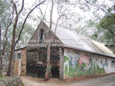
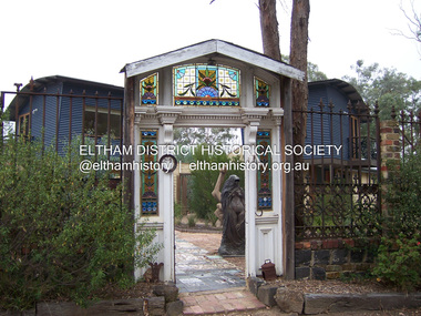
... The mud-brick and timber residence, made in stages with local materials, is rectangular, single-storey with a corrugated-iron roof. ...The mud-brick and timber residence, made in stages with local materials, is rectangular, single-storey with a corrugated-iron roof. ...Art Gallery with mural painted by Clifton Pugh (1924-1990) at his Artists' Colony, Dunmoochin, Barreenong Road, Cottles Bridge. Following military service in the second world war, Clifton Pugh studied under artist Sir William Dargie at the National Gallery School in Melbourne as well as Justus Jorgensen, founder of Montsalvat. For a while he lived on the dole but also worked packing eggs for the Belot family saving sufficient to purchase six acres (2.4 ha) of land at Barreenong Road, Cottles Bridge. He accumulated more land and persuaded several other artists and friends to buy land nearby, resulting in a property of approximately 200 acres, stablishing it as one of the first artistic communes in Australia alongside Montsalvat in Eltham. It was around 1951 that Pugh felt he had '"done moochin' around" and so the name of the property evolved. He bought timber from Alistair Knox to build his house on the crest of a hill. Inspired by local goldminer's huts, it was a one room wattle-and-daub structure with dirt floor. Over the years it expanded with thick adobe walls made from local clay, high ceilings and stone floors. All materials other than the local earth were sourced from second hand materials, most found at wreckers' yards. Artists from across the nation were drawn to Dunmoochin, with several setting up houses and shacks on the property, maintaining their independence but sharing their artistic zeal. Artists who worked or resided at Dunmoochin included Mirka Mora, John Perceval, Albert Tucker, Fred Williams, Charles Blackman, Arthur Boyd and John Olsen. In 2002, Pugh's house along with its treasure trove of art and a library of some 20,000 books was destroyed by fire. Traces of Pugh's home remain with the presence of the Victorian doorframe archway with leadlight of intricate design, procured from a demolished Melbourne mansion; and two bronze life-sized female statues created by Pugh and cast by Matcham Skipper. In place of Pugh's house rose two double-storey mud-brick artists' studios topped with corrugated iron rooves curved like the wings of a bird with accommodation for seven. The original studios, gallery and other buildings survived the fire. Covered under Heritage Overlay, Nillumbik Planning Scheme. Published: Nillumbik Now and Then / Marguerite Marshall 2008; photographs Alan King with Marguerite Marshall.; p153 It’s not surprising that artist Clifton Pugh was drawn to Cottles Bridge to establish his artists’ colony Dunmoochin. Undisturbed by the clamour of modern life at Barreenong Road, Pugh was surrounded by the Australian bush he loved, and where his ashes were later scattered. The 200 acres (81ha) of bushland, broken by glimpses of rolling hills, has more than 50 species of orchids and Pugh shared his property with native animals including kangaroos, emus, phascogales, wombats, and diverse bird life. Pugh encouraged these creatures to join him in the bush by creating, with Monash University, a holding station where the animals were raised. Dunmoochin inspired Pugh for such paintings as in a book on orchids and the Death of a Wombat series.1 But his love for the bush was accompanied by the fear that Europeans were destroying it and much of his painting illustrated this fear and his plea for its conservation.2 However it was his house rather than the surrounding bush that was to be destroyed. Tragically in 2002 Pugh’s house, with its treasure of art and library of 20,000 art books, was destroyed by fire. Traces of the beauty of Pugh’s home still remain, however, in the magnificent Victorian doorframe archway with leadlight of intricate design procured from a demolished Melbourne mansion; and two bronze life-sized female statues created by Pugh and cast by Matcham Skipper. Now in place of Pugh’s house, are two double-storey mud-brick artists’ studios topped with corrugated roofs curved like birds’ wings, with accommodation for seven. The original studios, gallery and other buildings remain.3 Pugh grew up on his parents’ hobby farm at Briar Hill and attended the Briar Hill Primary School, then Eltham High School and later Ivanhoe Grammar. At 15 he became a copy boy for the Radio Times newspaper, then worked as a junior in a drafting office. Pugh was to have three wives and two sons. After serving in World War Two in New Guinea and Japan, Pugh studied under artist Sir William Dargie, at the National Gallery School in Melbourne.4 Another of his teachers was Justus Jörgensen, founder of Montsalvat the Eltham Artists’ Colony. Pugh lived on the dole for a while and paid for his first six acres (2.4ha) at Barreenong Road by working as an egg packer for the Belot family. Pugh accumulated more land and persuaded several other artists and friends to buy land nearby, resulting in the 200 acre property. They, too, purchased their land from the Belot family by working with their chickens. Around 1951 Pugh felt he had ‘Done moochin’ around’ and so the name of his property was born. Pugh bought some used timber from architect Alistair Knox to build his house on the crest of a hill. Inspired by local goldminers’ huts it was a one-room wattle-and-daub structure with a dirt floor. It was so small that the only room he could find for his telephone was on the fork of a tree nearby.5 Over the years the mud-brick house grew to 120 squares in the style now synonymous with Eltham. It had thick adobe walls (sun-dried bricks) made from local clay, high ceilings and stone floors with the entire structure made of second-hand materials – most found at wreckers’ yards. Pugh’s first major show in Melbourne in 1957, established him as a distinctive new painter, breaking away from the European tradition ‘yet not closely allied to any particular school of Australian painting’.6 Pugh became internationally known and was awarded the Order of Australia. He won the Archibald Prize for portraiture three times, although he preferred painting the bush and native animals. In 1990 not long before he died, Pugh was named the Australian War Memorial’s official artist at the 75th anniversary of the landing at Gallipoli. Today one of Pugh’s legacies is the Dunmoochin Foundation, which gives seven individual artists or couples and environmental researchers the chance to work in beautiful and peaceful surroundings, usually for a year. By November 2007, more than 80 people had taken part, and the first disabled artist had been chosen to reside in a new studio with disabled access.1 In 1989, not long before Pugh died in 1990 of a heart attack at age 65, he established the Foundation with La Trobe University and the Victorian Conservation Trust now the Trust for Nature. Pugh’s gift to the Australian people – of around 14 hectares of bushland and buildings and about 550 art works – is run by a voluntary board of directors, headed by one of his sons, Shane Pugh. La Trobe University in Victoria stores and curates the art collection and organises its exhibition around Australia.2 The Foundation aims to protect and foster the natural environment and to provide residences, studios and community art facilities at a minimal cost for artists and environmental researchers. They reside at the non-profit organisation for a year at minimal cost. The buildings, some decorated with murals painted by Pugh and including a gallery, were constructed by Pugh, family and friends, with recycled as well as new materials and mud-bricks. The Foundation is inspired by the tradition begun by the Dunmoochin Artists’ Cooperative which formed in the late 1950s as one of the first artistic communes in Australia. Members bought the land collaboratively and built the seven dwellings so that none could overlook another. But, in the late 1960s, the land was split into private land holdings, which ended the cooperative. Dunmoochin attracted visits from the famous artists of the day including guitarists John Williams and Segovia; singer and comedian Rolf Harris; comedian Barry Humphries; and artists Charles Blackman, Arthur Boyd and Mirka Mora. A potters’ community, started by Peter and Helen Laycock with Alma Shanahan, held monthly exhibitions in the 1960s, attracting local, interstate and international visitors – with up to 500 attending at a time.3 Most artists sold their properties and moved away. But two of the original artists remained into the new millennium as did relative newcomer Heja Chong who built on Pugh’s property (now owned by the Dunmoochin Foundation). In 1984 Chong brought the 1000-year-old Japanese Bizan pottery method to Dunmoochin. She helped build (with potters from all over Australia) the distinctive Bizan-style kiln, which fires pottery from eight to 14 days in pine timber, to produce the Bizan unglazed and simple subdued style. The kiln, which is rare in Australia, is very large with adjoining interconnected ovens of different sizes, providing different temperatures and firing conditions. Frank Werther, who befriended Pugh as a fellow student at the National Gallery Art School in Melbourne, built his house off Barreenong Road in 1954. Werther is a painter of the abstract and colourist style and taught art for about 30 years. Like so many in the post-war years in Eltham Shire, as it was called then, Werther built his home in stages using mud-brick and second-hand materials. The L-shaped house is single-storey but two-storey in parts with a corrugated-iron pitched roof. The waterhole used by the Werthers for their water supply is thought to be a former goldmining shaft.4 Alma Shanahan at Barreenong Road was the first to join Pugh around 1953. They also met at the National Gallery Art School and Shanahan at first visited each weekend to work, mainly making mud-bricks. She shared Pugh’s love for the bush, but when their love affair ended, she designed and built her own house a few hundred yards (metres) away. The mud-brick and timber residence, made in stages with local materials, is rectangular, single-storey with a corrugated-iron roof. As a potter, Shanahan did not originally qualify as an official Cooperative member.This collection of almost 130 photos about places and people within the Shire of Nillumbik, an urban and rural municipality in Melbourne's north, contributes to an understanding of the history of the Shire. Published in 2008 immediately prior to the Black Saturday bushfires of February 7, 2009, it documents sites that were impacted, and in some cases destroyed by the fires. It includes photographs taken especially for the publication, creating a unique time capsule representing the Shire in the early 21st century. It remains the most recent comprehenesive publication devoted to the Shire's history connecting local residents to the past. nillumbik now and then (marshall-king) collection, art gallery, clifton pugh, dunmoochin, cottlesbridge, cottles bridge, barreenong road -
 Eltham District Historical Society Inc
Photograph - Digital Photograph, Marguerite Marshall, Doorway of Clifton Pugh's former house at Dunmoochin, Barreenong Road, Cottles Bridge, 5 February 2008
... The mud-brick and timber residence, made in stages with local materials, is rectangular, single-storey with a corrugated-iron roof. ...The mud-brick and timber residence, made in stages with local materials, is rectangular, single-storey with a corrugated-iron roof. ...Following military service in the second world war, Clifton Pugh studied under artist Sir William Dargie at the National Gallery School in Melbourne as well as Justus Jorgensen, founder of Montsalvat. For a while he lived on the dole but also worked packing eggs for the Belot family saving sufficient to purchase six acres (2.4 ha) of land at Barreenong Road, Cottles Bridge. He accumulated more land and persuaded several other artists and friends to buy land nearby, resulting in a property of approximately 200 acres, stablishing it as one of the first artistic communes in Australia alongside Montsalvat in Eltham. It was around 1951 that Pugh felt he had '"done moochin' around" and so the name of the property evolved. He bought timber from Alistair Knox to build his house on the crest of a hill. Inspired by local goldminer's huts, it was a one room wattle-and-daub structure with dirt floor. Over the years it expanded with thick adobe walls made from local clay, high ceilings and stone floors. All materials other than the local earth were sourced from second hand materials, most found at wreckers' yards. Artists from across the nation were drawn to Dunmoochin, with several setting up houses and shacks on the property, maintaining their independence but sharing their artistic zeal. Artists who worked or resided at Dunmoochin included Mirka Mora, John Perceval, Albert Tucker, Fred Williams, Charles Blackman, Arthur Boyd and John Olsen. In 2002, Pugh's house along with its treasure trove of art and a library of some 20,000 books was destroyed by fire. Traces of Pugh's home remain with the presence of the Victorian doorframe archway with leadlight of intricate design, procured from a demolished Melbourne mansion; and two bronze life-sized female statues created by Pugh and cast by Matcham Skipper. In place of Pugh's house rose two double-storey mud-brick artists' studios topped with corrugated iron rooves curved like the wings of a bird with accommodation for seven. The original studios, gallery and other buildings survived the fire. Covered under Heritage Overlay, Nillumbik Planning Scheme. Published: Nillumbik Now and Then / Marguerite Marshall 2008; photographs Alan King with Marguerite Marshall.; p155 It’s not surprising that artist Clifton Pugh was drawn to Cottles Bridge to establish his artists’ colony Dunmoochin. Undisturbed by the clamour of modern life at Barreenong Road, Pugh was surrounded by the Australian bush he loved, and where his ashes were later scattered. The 200 acres (81ha) of bushland, broken by glimpses of rolling hills, has more than 50 species of orchids and Pugh shared his property with native animals including kangaroos, emus, phascogales, wombats, and diverse bird life. Pugh encouraged these creatures to join him in the bush by creating, with Monash University, a holding station where the animals were raised. Dunmoochin inspired Pugh for such paintings as in a book on orchids and the Death of a Wombat series.1 But his love for the bush was accompanied by the fear that Europeans were destroying it and much of his painting illustrated this fear and his plea for its conservation.2 However it was his house rather than the surrounding bush that was to be destroyed. Tragically in 2002 Pugh’s house, with its treasure of art and library of 20,000 art books, was destroyed by fire. Traces of the beauty of Pugh’s home still remain, however, in the magnificent Victorian doorframe archway with leadlight of intricate design procured from a demolished Melbourne mansion; and two bronze life-sized female statues created by Pugh and cast by Matcham Skipper. Now in place of Pugh’s house, are two double-storey mud-brick artists’ studios topped with corrugated roofs curved like birds’ wings, with accommodation for seven. The original studios, gallery and other buildings remain.3 Pugh grew up on his parents’ hobby farm at Briar Hill and attended the Briar Hill Primary School, then Eltham High School and later Ivanhoe Grammar. At 15 he became a copy boy for the Radio Times newspaper, then worked as a junior in a drafting office. Pugh was to have three wives and two sons. After serving in World War Two in New Guinea and Japan, Pugh studied under artist Sir William Dargie, at the National Gallery School in Melbourne.4 Another of his teachers was Justus Jörgensen, founder of Montsalvat the Eltham Artists’ Colony. Pugh lived on the dole for a while and paid for his first six acres (2.4ha) at Barreenong Road by working as an egg packer for the Belot family. Pugh accumulated more land and persuaded several other artists and friends to buy land nearby, resulting in the 200 acre property. They, too, purchased their land from the Belot family by working with their chickens. Around 1951 Pugh felt he had ‘Done moochin’ around’ and so the name of his property was born. Pugh bought some used timber from architect Alistair Knox to build his house on the crest of a hill. Inspired by local goldminers’ huts it was a one-room wattle-and-daub structure with a dirt floor. It was so small that the only room he could find for his telephone was on the fork of a tree nearby.5 Over the years the mud-brick house grew to 120 squares in the style now synonymous with Eltham. It had thick adobe walls (sun-dried bricks) made from local clay, high ceilings and stone floors with the entire structure made of second-hand materials – most found at wreckers’ yards. Pugh’s first major show in Melbourne in 1957, established him as a distinctive new painter, breaking away from the European tradition ‘yet not closely allied to any particular school of Australian painting’.6 Pugh became internationally known and was awarded the Order of Australia. He won the Archibald Prize for portraiture three times, although he preferred painting the bush and native animals. In 1990 not long before he died, Pugh was named the Australian War Memorial’s official artist at the 75th anniversary of the landing at Gallipoli. Today one of Pugh’s legacies is the Dunmoochin Foundation, which gives seven individual artists or couples and environmental researchers the chance to work in beautiful and peaceful surroundings, usually for a year. By November 2007, more than 80 people had taken part, and the first disabled artist had been chosen to reside in a new studio with disabled access.1 In 1989, not long before Pugh died in 1990 of a heart attack at age 65, he established the Foundation with La Trobe University and the Victorian Conservation Trust now the Trust for Nature. Pugh’s gift to the Australian people – of around 14 hectares of bushland and buildings and about 550 art works – is run by a voluntary board of directors, headed by one of his sons, Shane Pugh. La Trobe University in Victoria stores and curates the art collection and organises its exhibition around Australia.2 The Foundation aims to protect and foster the natural environment and to provide residences, studios and community art facilities at a minimal cost for artists and environmental researchers. They reside at the non-profit organisation for a year at minimal cost. The buildings, some decorated with murals painted by Pugh and including a gallery, were constructed by Pugh, family and friends, with recycled as well as new materials and mud-bricks. The Foundation is inspired by the tradition begun by the Dunmoochin Artists’ Cooperative which formed in the late 1950s as one of the first artistic communes in Australia. Members bought the land collaboratively and built the seven dwellings so that none could overlook another. But, in the late 1960s, the land was split into private land holdings, which ended the cooperative. Dunmoochin attracted visits from the famous artists of the day including guitarists John Williams and Segovia; singer and comedian Rolf Harris; comedian Barry Humphries; and artists Charles Blackman, Arthur Boyd and Mirka Mora. A potters’ community, started by Peter and Helen Laycock with Alma Shanahan, held monthly exhibitions in the 1960s, attracting local, interstate and international visitors – with up to 500 attending at a time.3 Most artists sold their properties and moved away. But two of the original artists remained into the new millennium as did relative newcomer Heja Chong who built on Pugh’s property (now owned by the Dunmoochin Foundation). In 1984 Chong brought the 1000-year-old Japanese Bizan pottery method to Dunmoochin. She helped build (with potters from all over Australia) the distinctive Bizan-style kiln, which fires pottery from eight to 14 days in pine timber, to produce the Bizan unglazed and simple subdued style. The kiln, which is rare in Australia, is very large with adjoining interconnected ovens of different sizes, providing different temperatures and firing conditions. Frank Werther, who befriended Pugh as a fellow student at the National Gallery Art School in Melbourne, built his house off Barreenong Road in 1954. Werther is a painter of the abstract and colourist style and taught art for about 30 years. Like so many in the post-war years in Eltham Shire, as it was called then, Werther built his home in stages using mud-brick and second-hand materials. The L-shaped house is single-storey but two-storey in parts with a corrugated-iron pitched roof. The waterhole used by the Werthers for their water supply is thought to be a former goldmining shaft.4 Alma Shanahan at Barreenong Road was the first to join Pugh around 1953. They also met at the National Gallery Art School and Shanahan at first visited each weekend to work, mainly making mud-bricks. She shared Pugh’s love for the bush, but when their love affair ended, she designed and built her own house a few hundred yards (metres) away. The mud-brick and timber residence, made in stages with local materials, is rectangular, single-storey with a corrugated-iron roof. As a potter, Shanahan did not originally qualify as an official Cooperative member.This collection of almost 130 photos about places and people within the Shire of Nillumbik, an urban and rural municipality in Melbourne's north, contributes to an understanding of the history of the Shire. Published in 2008 immediately prior to the Black Saturday bushfires of February 7, 2009, it documents sites that were impacted, and in some cases destroyed by the fires. It includes photographs taken especially for the publication, creating a unique time capsule representing the Shire in the early 21st century. It remains the most recent comprehenesive publication devoted to the Shire's history connecting local residents to the past. nillumbik now and then (marshall-king) collection, art gallery, clifton pugh, dunmoochin, cottlesbridge, cottles bridge, barreenong road -
 Bendigo Military Museum
Sign - ILLUMINATED, RSL LOGO, pre 1990's
... residence. It was mainly used at RSL meetings. When the RSL Meetings moved to the B&DRSL Club Inc it was used during the day when the Museum was open. After the renovations to the Soldiers memorial in 2018 it was placed in what is now the Building & RSL History room of the BMM. brsl smirsl sign rsl logo "Returned Services League Australia" Sign, timber construction box shape, illuminated faces front and rear with the RSL Logo in colour. ...This sign was used in the Billiard room of the Soldiers Memorial Institute Bendigo RSL. Years ago when the Billiard room had a section divided off for part of a Caretakers Residence it was placed on the internal roof of the residence. It was mainly used at RSL meetings. When the RSL Meetings moved to the B&DRSL Club Inc it was used during the day when the Museum was open. After the renovations to the Soldiers memorial in 2018 it was placed in what is now the Building & RSL History room of the BMM.Sign, timber construction box shape, illuminated faces front and rear with the RSL Logo in colour. Illumination is via a single globe."Returned Services League Australia"brsl, smirsl, sign, rsl logo -
 Orbost & District Historical Society
letter book, James Yeates & Sons (Printing) Pty Ltd, 1977
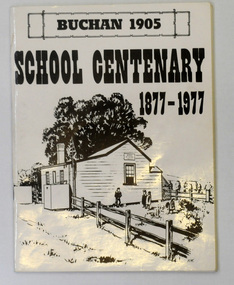
... timber, because it still serves as the shelter pavilion. On 11th of July 1878 William Scott opened the first school of approximately 40 pupils ranging from Grade 1 - 8. A larger weatherboard school was erected in 1914. A residence...timber, because it still serves as the shelter pavilion. On 11th of July 1878 William Scott opened the first school of approximately 40 pupils ranging from Grade 1 - 8. A larger weatherboard school was erected in 1914. A residence ...This book was prepared for the Buchan School centenary. In the Buchan District itinerant teaching was conducted in buildings with log walls and a bark roof typical of the mid 19th century. Not until 1878 was the first State school built on the same general site as the present school, on the Orbost Rd, ⅓ of a mile from the bridge over the Buchan River. This original school building must have been constructed from high quality timber, because it still serves as the shelter pavilion. On 11th of July 1878 William Scott opened the first school of approximately 40 pupils ranging from Grade 1 - 8. A larger weatherboard school was erected in 1914. A residence was provided for the HT in 1934 and in 1956 a second classroom erected and attached to the 1914 building. Unfortunately, all records of the Committee were lost in a fire when the homestead of Alex Cameron, then serving as Committee Secretary, was burnt to the ground, but it is well known to local citizens that Frank Moon, local prospector, explorer and discoverer of the famous Buchan Limestone Caves, attended school at SS1905 Buchan. (ref SCHOOLS EAST GIPPSLAND - John Phillips)This book is a useful research tool on the history of Buchan.Two copies of a 273 pp paper covered booklet. The cover is white with the title in black print. On the front is a sketch of an old school building. On the back is a black/white photograph of children running downhill. A book on the history of the Buchan school no.1905. Includes photographs, maps and lists of school students and staff.book buchan-history buchan-school -
 Eltham District Historical Society Inc
Photograph - Digital Photograph, Jim Connor, River Bend House, 130 Laughing Waters Road, Eltham, 7 September 2013
... residence at Birrarung House and we had a brief opportunity to view inside the house. River Bend was designed and built by Alistair Knox for Rosemary and Bill Cuming in 1968. It sits in a deep cutting on a steep slope above the Yarra River and features floor to ceiling windows and glass doors set into mission brown timber frames and walls of reclaimed bricks in pinkish hue. ...residence at Birrarung House and we had a brief opportunity to view inside the house. River Bend was designed and built by Alistair Knox for Rosemary and Bill Cuming in 1968. It sits in a deep cutting on a steep slope above the Yarra River and features floor to ceiling windows and glass doors set into mission brown timber frames and walls of reclaimed bricks in pinkish hue. ...Laughing Waters Walk, 7 Sep 2013 This Society excursion was a follow up to the Laughing Waters Story told to us by Jane Woollard at our Annual General Meeting in March 2013. It involved a walk commencing from the corner of Laughing Waters and Overbank Roads along Laughing Waters Road to its eastern end and returning partly over the same route - a total distance of about 2.5km. On the way we visited the two artist in residence properties, River Bend and Birrarung, to view the houses on them that are associated with Alistair Knox, Gordon Ford and others in the local mud brick and artistic community. We also able to walk around the derelict ruin which was once home to Gordon and Sue Ford, Boomerang House. An unexpected afternoon tea was offered to us by the artists in residence at Birrarung House and we had a brief opportunity to view inside the house. River Bend was designed and built by Alistair Knox for Rosemary and Bill Cuming in 1968. It sits in a deep cutting on a steep slope above the Yarra River and features floor to ceiling windows and glass doors set into mission brown timber frames and walls of reclaimed bricks in pinkish hue. Rosemary laid the brick paving around the house, a copy of the shell paving found in the ancient French town of Colmar, where the family had lived for a period. The kitchen was equipped with a 1960s stove as well as a cast iron wood stove reclaimed from Rosemary's sister's home in Armadale. Max and Tini Huygens, migrants from Holland, purchased the property in 1975 and named it Tilwinda from an Aboriginal word meaning 'hole in a rock'. In late 1981 Tini died after a short illness, but Max continued to live at Tilwinda until he moved to a retirement village in 2000 and the property was sold to Parks Victoria. Renamed River Bend, the property became part of the Laughing Waters Artist in Residency Program in 2008. Nillumbik Shire Council upgraded the property in 2012 with solar panels, a heat pump for hot water and double glazing to improve the comfort of the artists in residence and make the house more energy efficient. For a more in-depth description of the property and biographies of the various artists in residence commencing from 2008 to 2015, see Jane Woollard's book, "Laughing Waters Road; Art, Landscape & Memory in Eltham" published 2016.2013-09-07, activities, artists in residence, eltham district historical society, heritage excursion, jim connor collection, laughing waters road, river bend house -
 Eltham District Historical Society Inc
Document - Property Binder, 16 Homestead Road, Eltham, 'Handfield House'
... timber, some concrete?. Features include the modular wall design, courtyard planning, combination of single and double storey sections, internal planning and floor to ceiling glass walls. SOURCES OF INFORMATION: Information from Mr. John Handfield. CONSERVATION GUIDELINES: Keep this residence...timber, some concrete?. Features include the modular wall design, courtyard planning, combination of single and double storey sections, internal planning and floor to ceiling glass walls. SOURCES OF INFORMATION: Information from Mr. John Handfield. CONSERVATION GUIDELINES: Keep this residence ...Contents: 1. Morrison Kleeman Sales brochure 2008 2. Newsclipping; Advertisement, Morrison Kleeman, Eltham South 16 Homestead Road, Diamond Valley Leader, November 5, 2008, p7 (on reverse, p8 Advertisement, Morrison Kleeman, Eltham 45 Lavender Park Road) Designed by Robin Boyd for friends John and Esta Handfield, Handfield House was built 1961. In a letter dated 16 May 1989 to Blanche Shallard of the Shire of Eltham Historical Society, John Handfield advised that the house was designed by their friend Robin Boyd and that it was built in 1961. As of that date they had been the only occupants. They were still the owners when the house was included in the 1992 Shire of Eltham Heritage Study The 1992 Study advised: CULTURAL SIGNIFICANCE Designed by well-known Victorian Architect Robin Boyd after he returned from lecturing architectural students in Japan, the Handfield residence shows the influence of traditional Japanese design in its modular wall arrangements, solid and glazed panels and sliding exterior doors. The courtyard planning, floor to ceiling glass walls and the combination of single and double storey sections on the steep site illustrate quite advanced dwelling design for its time. Designed to house three generations, grandparents, their children and grandchildren, the house at the time of the 1992 study was reported to be very intact. DESCRIPTION Quite advanced design, in planning and detailing. Plan U-shaped. Single and double storied; the arms of the U are basically single storied, while the base running parallel with the Yarra River is two storied. Walls timber stud framed?, asbestos cement sheet clad. Roofs flat?. Floors timber, some concrete?. Features include the modular wall design, courtyard planning, combination of single and double storey sections, internal planning and floor to ceiling glass walls. SOURCES OF INFORMATION: Information from Mr. John Handfield. CONSERVATION GUIDELINES: Keep this residence intact. Esta Handfield died in 1995 The property was sold in 1996 Property history (source realestate.com.au) 2022 – Sold $2,240,000 September 17, 2022 by Jellis Craig - Eltham 1998 – Sold $348,500 June 20, 1998 1996 – Sold $250,000 September 9, 1996 (possibly Stockdale & Leggo) The property was offered for sale in 2008 by Morrison Kleeman with a price guide of $900,00 to $990,00 but it has not been confirmed if this sale proceeded property, eltham, houses, john handfield, esta handfield, robin boyd, 16 homestead road, handfield house, 45 lavender park road -
 Eltham District Historical Society Inc
Photograph - Digital Photograph, Alan King, Eltham Court House, 730 Main Road, Eltham, 28 December 2007
... Builders, Langridge Wright and Witney built a timber police station (since demolished) and a brick residence to its north,2 for £1150/7/-. ...Builders, Langridge Wright and Witney built a timber police station (since demolished) and a brick residence to its north,2 for £1150/7/-. ...The Eltham Court House is Eltham's oldest public building. It was classified by the National Trust in 1977. In 1857 five Eltham residents petitioned the licensing magistrates of the Heidelberg district asking for better police protection, including from itinerant gold prospectors who turned to crime when their quest was unsuccessful. In response the Eltham Courthouse was constructed in 1860. Over the years it has also been used for other activities, including for electoral polling purposes, inquests, early meetings of the Eltham Roads Board and even as an overflow classroom. This type of localised solution is characteristic of the self-reliance preserved in Eltham today. The court house is an important symbol of the spirit which makes Eltham distinctive as a community. The Eltham Courthouse is historically significant because its construction was intended to emphasise the centralised control over law and order in the Colony of Victoria in the wake of the 1852 Snodgrass committee report on the Victorian police force and the resulting Police Regulation Act (1853). The nature of the Court House planning and use of architectural devices make the building's function easily interpreted. The arrangement of rooms, with public entry and clerical rooms to the rear, and the use of raised floor levels throughout these spaces to signify relative rank is easily perceived. The distinction in entries, public, magistrate and person-in-custody, and the existing court furniture enhances appreciation of this building. The Eltham Court House is one of only two intact examples in the state of this simple design with projecting entry. The building is of architectural significance because it retains intact early features. These include use of handmade bricks, simple decoration, roof trusses, timber ceiling boards, original windows, doors and associated hardware and a collection of court furniture. Additions to the court house have been done in a manner which did not interfere with the fabric of the original building. Typical cases heard before the Court of Petty Sessions included financial debt, straying livestock, theft, assault, drunkenness, public disorder, truancy, motor vehicle offences, unregistered animals and failing to have children attend school, or be vaccinated. The courthouse operated for over 120 years before it closed in 1985. In April 2021, Nillumbik Shire Council authorised restoration of the building and furnishings. The extensive works required for the total restoration of this highly valued heritage building was undertaken by Ducon Building Solutions and other specialist contractors. Covered under Heritage Overlay, Nillumbik Planning Scheme. Victorian Heritage National Trust of Australia (Victoria) State significance Published: Nillumbik Now and Then / Marguerite Marshall 2008; photographs Alan King with Marguerite Marshall.; p65 A demand for better police protection resulted in the building of the Eltham Courthouse and the police residence beside it. In 1857 five Eltham residents petitioned the Heidelberg district licensing magistrates. They pointed out that Eltham had two hotels, a population of about 1000, and many strangers employed on the public roads. Yet the nearest police were at Heidelberg eight miles (12.8km) away, or at the Caledonia Diggings 21 miles (33.7km) away.1 Subsequently the courthouse and then the police residence, near the corner of Main Road and Brougham Street, were built in 1859/60. The courthouse is Eltham’s oldest public building and the National Trust classified it in 1977. It ceased operation in 1984 and has since been used by local groups. There are only six other known examples of similar small brick country courthouses in Victoria . For £536, a Mr Duncan built the courthouse – a neat, narrow, oblong building with handmade orange bricks. Its gabled roof and porch are covered with brown slate tiles and it has 12-paned windows. Inside, the roof is peaked and the courthouse is still ventilated by oblong slits near the ceiling. Most of the fine carved timber and upholstered furniture is original. The original prisoners’ door, now permanently closed, led from the police station to the dock. Builders, Langridge Wright and Witney built a timber police station (since demolished) and a brick residence to its north,2 for £1150/7/-. Built around the same time were the lock-up behind the residence, also later demolished, and the two-storey orange brick stables. The former police residence also has a brown slate roof and handmade bricks. The front veranda roof is made of corrugated iron, as is the roof of the back weatherboard extension. The application for police protection was approved within a few months and police operated from a cottage rented at ten shillings a week and owned by William Jarrold. This was probably the one at the corner of Main Road and Dalton Street called Jarrold or White Cloud Cottage. In 1858 a second constable was appointed to Eltham following a fight at the hotel. The timber police office a replica of which was built in the early 1990s is at the building’s side. The lock-up was demolished following the relocation of the police to a new station in about 1952. The residence has been used as the Eltham District Historical Society centre since 1997. Records show court cases were held at Eltham before the courthouse was built, but the location is unknown. Some court cases were not very different from those today. In 1891 a man was charged with being drunk while in charge of a horse and was fined ten shillings. The courthouse was used for other purposes during its long history. It was probably used as a polling place as indicated by old photographs of election-day crowds outside. The Eltham Road Board met there from the early 1860s until 1868 when the Board transferred to Kangaroo Ground. During the same period the Road Board Secretary used the courthouse as an office until 1867 when it was transferred to his home at Wingrove Cottage. The courthouse was also used as an overflow classroom for the Dalton Street school in 1875. The two buildings can further link us with Eltham’s early days through Police Department correspondence. The first constable-in-charge was George Reid. In 1860 a letter to The Argus newspaper signed ‘A Sufferer’ declared the Eltham police were not active enough in their duties. The writer suggested that the ‘very snug’ police quarters were too comfortable, and he detailed various incidents including one of an alleged break-in to the Road Board Secretary’s home. But the Board Secretary, C S Wingrove, wrote to the Police Department refuting The Argus letter saying he had received full co-operation from Sen. Constable Peter Lawler.This collection of almost 130 photos about places and people within the Shire of Nillumbik, an urban and rural municipality in Melbourne's north, contributes to an understanding of the history of the Shire. Published in 2008 immediately prior to the Black Saturday bushfires of February 7, 2009, it documents sites that were impacted, and in some cases destroyed by the fires. It includes photographs taken especially for the publication, creating a unique time capsule representing the Shire in the early 21st century. It remains the most recent comprehenesive publication devoted to the Shire's history connecting local residents to the past. nillumbik now and then (marshall-king) collection, eltham, eltham court house, main road -
 Eltham District Historical Society Inc
Photograph - Digital Photograph, Alan King, St Andrews Anglican Church, St Andrews, 30 January 2008
... Still standing, this building is now used as the St Andrews Community Centre and the residence is leased for private use. The original timber-lined room remains alongside the extensions, and is distinctive with its high ceiling and tall small-paned windows. ...Still standing, this building is now used as the St Andrews Community Centre and the residence is leased for private use. The original timber-lined room remains alongside the extensions, and is distinctive with its high ceiling and tall small-paned windows. ...Built c.1868, St Andrew’s Anglican Church is Nillumbik Shire’s oldest timber church and is historically, socially, and spiritually significant to the Shire of Nillumbik. The church is historically significant because it may have given its name 'St Andrews' to the town (another suggestion is that the name came from the local hotel), it is also historically significant as one of only four buildings that remain from the Caledonian goldfields era of Queenstown (now St Andrews) and one of only a handful of buildings that survived the 1960s bushfires. The church is historically, socially, and spiritually significant because it has played an important part in community life for more than 150 years; a proposal to move the church in 1984 met with strenuous opposition. Much of the fires on Black Saturday 2009 were the north of the town. The town itself remained intact - as did this heritage building. Covered under Heritage Overlay, Nillumbik Planning Scheme. National Trust of Australia (Victoria) Local significance Published: Nillumbik Now and Then / Marguerite Marshall 2008; photographs Alan King with Marguerite Marshall.; p69 The St Andrews Anglican Church and former St Andrews Primary School, are two reminders of the district’s early days, when it was founded on gold. St Andrews, then called Queenstown, was the earliest goldfield in the Caledonia Diggings.1 It was the Upper Diamond Gold Mining and Administrative Centre, with 3000 miners. Queenstown was also the seat of the Court of Petty Sessions. The church and school then stood close to European and Chinese stores, three hotels, a brewery and a quartz mill.2 In 1861, Queenstown was officially proclaimed a township. From 1865, the name Queenstown was interchangeable with St Andrews, until 1952, when the town was officially named St Andrews. As gold declined from the early 1880s, Queenstown changed dramatically into a settlement of small farms. St Andrew’s Anglican Church, built in 1868, is the Shire’s oldest timber church and possibly gave its name to the township.3 The small timber church was opened on November 1, 1869, by the Dean of Melbourne. Anniversary tea meetings helped raise funds, and in 1889, a three-bedroom parsonage was built alongside. In 1910, the vicar, the Rev Selwyn Chase (and friend of the Scouting Movement’s founder, Baden Powell), established the 1st Queenstown Scout Troop, only two years after Scouting began in Australia. The church was important to the lives of many local residents who were baptised, married and had funeral services there. But by the 1950s the population had decreased and so did the weekly attendances. Around the mid-1960s the church closed, then fell into disrepair. So in the mid 1980s it was sold to the Education Department and was under threat of relocation or demolition. However this caused such opposition from locals,4 that instead, the Anglican church leased it as part of the Panton Hill parish5 and it was reconsecrated in 1987. Queenstown’s first school was held in a tent after transferring from Andersons Creek, Warrandyte.6 From 1858 a church school, Caledonia Diggings, stood west of the main road, a quarter of a mile (0.4km) before Buttermans Track. In 1882 the school was moved from a leased building, owned by headmaster Robert Harris, into a larger building on the corner of the School and the Heidelberg-Kinglake Roads. It had been moved from Smiths Gully and included a teacher’s three-roomed residence.7 In 1887 the school was replaced by the Queenstown State School No 128, although it was also called Caledonia Diggings until 1891. In 1956 it was renamed St Andrews. Still standing, this building is now used as the St Andrews Community Centre and the residence is leased for private use. The original timber-lined room remains alongside the extensions, and is distinctive with its high ceiling and tall small-paned windows. In 1984 a new school was built 500 metres west of the old school. Many residents have contributed much to St Andrews but one family that has done so for several generations is the Harris family. Robert Harris was an active member of the St Andrew’s Anglican Church, and worked hard at improving the town’s amenities until his death in 1887. He was a signatory to the successful 1863 petition to the Chief Commissioner of Police, against the proposed removal of the Court of Petty Sessions and police station at the Caledonia Diggings. The police station stayed in the town until 1917. Harris was Head Teacher of Queenstown State School from 1864 to 1874, then of the Smiths Gully school until it closed in 1882, and he continued teaching at Panton Hill until his death. His son, Robert Charles Harris, was editor and printer of the local newspaper, The Evelyn Observer, from 1873 until 1915. Robert’s son, William Shelley Harris, served in the Boer War and in World War One. In 1928 he became Kinglake National Park’s first park ranger. Robert’s daughter Elizabeth, taught needlework at Queenstown State School, and later ran the post office in Kinglake.This collection of almost 130 photos about places and people within the Shire of Nillumbik, an urban and rural municipality in Melbourne's north, contributes to an understanding of the history of the Shire. Published in 2008 immediately prior to the Black Saturday bushfires of February 7, 2009, it documents sites that were impacted, and in some cases destroyed by the fires. It includes photographs taken especially for the publication, creating a unique time capsule representing the Shire in the early 21st century. It remains the most recent comprehenesive publication devoted to the Shire's history connecting local residents to the past. nillumbik now and then (marshall-king) collection, st andrews, st andrews anglican church -
 Glen Eira Historical Society
Album - Album page, Lucan Street, 7, Circa 1972
... residence...verandah...terraces...timber...All photographs are black and white except where stated, with 386 photographs over 198 pages. trevor hart caulfield north villa residence verandah terraces timber roof brackets gables cast iron ridging ornate plasterwork arched windows curved windows chimneys lucan street victorian style cast iron work houses Handwritten: 7 Lucan Street [top right] / 122 [bottom right] Page 122 of Photograph Album with one landscape photograph of a house at 7 Lucan Street. ...This photograph is part of the Caulfield Historical Album 1972. This album was created in approximately 1972 as part of a project by the Caulfield Historical Society to assist in identifying buildings worthy of preservation. The album is related to a Survey the Caulfield Historical Society developed in collaboration with the National Trust of Australia (Victoria) and Caulfield City Council to identify historic buildings within the City of Caulfield that warranted the protection of a National Trust Classification. Principal photographer thought to be Trevor Hart, member of Caulfield Historical Society. Most photographs were taken between 1966-1972 with a small number of photographs being older and from unknown sources. All photographs are black and white except where stated, with 386 photographs over 198 pages. Page 122 of Photograph Album with one landscape photograph of a house at 7 Lucan Street.Handwritten: 7 Lucan Street [top right] / 122 [bottom right]trevor hart, caulfield north, villa residence, verandah, terraces, timber roof brackets, gables, cast iron ridging, ornate plasterwork, arched windows, curved windows, chimneys, lucan street, victorian style, cast iron work, houses -
 Glen Eira Historical Society
Album - Album page, Labassa Conservatory, 21 Manor Grove, Circa 1972
... Internally the floor appears to have been raised as part of the conversion work to a residence, and stained timber panelling introduced to provide room spaces. ...Internally the floor appears to have been raised as part of the conversion work to a residence, and stained timber panelling introduced to provide room spaces. ...This photograph is part of the Caulfield Historical Album 1972. This album was created in approximately 1972 as part of a project by the Caulfield Historical Society to assist in identifying buildings worthy of preservation. The album is related to a Survey the Caulfield Historical Society developed in collaboration with the National Trust of Australia (Victoria) and Caulfield City Council to identify historic buildings within the City of Caulfield that warranted the protection of a National Trust Classification. Principal photographer thought to be Trevor Hart, member of Caulfield Historical Society. Most photographs were taken between 1966-1972 with a small number of photographs being older and from unknown sources. All photographs are black and white except where stated, with 386 photographs over 198 pages. WHAT IS SIGNIFICANT? [From Victorian Heritage Database citation for Former Labassa Conservatory - H2005 Victorian Heritage Register http://vhd.heritage.vic.gov.au/places/result_detail/12504 (25/01/2021)] The former Labassa Conservatory is believed to have been built as part of the extensive reworking of the Labassa estate in c1890 for the new owner Alexander Robertson, proprietor of the Cobb and Co line. Robertson commissioned the architect JAB Koch to remodel the house, and Koch may have been responsible for the conservatory as well. Alternatively, the conservatory may have been imported. The gates installed at Labassa in 1890 were manufactured by the MacFarlane foundry of Glasgow, Scotland, a firm known to have manufactured conservatories. Around 1917 the glass house from 'Labassa', Caulfield was offered for sale to Malvern Council for its own gardens but the offer was declined. Following subdivision of the Labassa estate in the 1920s the conservatory was converted into a residence. The structure has a simple rectangular plan, with a brick base and superstructure of cast iron columns and roof trusses. The hipped roof is surmounted by an elaborately decorated gable structure. Most of the original glass has been replaced by metal sheeting. The decoration comprises pressed metal fascias including an egg and dart style cornice moulding, mullion mouldings and gable end panels with a rising sun motif. Cast iron ridgework and finials add to the lively roof form. Internally the floor appears to have been raised as part of the conversion work to a residence, and stained timber panelling introduced to provide room spaces. Boilers probably heated the conservatory in the colder months, but these do not survive.From Victorian Heritage Database citation for Former Labassa Conservatory - H2005 http://vhd.heritage.vic.gov.au/places/result_detail/12504 (25/01/2021) HOW IS IT SIGNIFICANT? The former Labassa Conservatory is of historical and architectural significance to the State of Victoria. WHY IS IT SIGNIFICANT? The former Labassa Conservatory is historically significant for its associations with the Labassa estate. Subdivision of the estate separated a number of outbuildings from the mansion. The former conservatory is significant as part of the large scale improvements carried out to the estate in the 1890s. The nineteenth century was the great age of conservatory designs, enabled by technological developments in heating, glazing and iron. Whilst conservatories were common in botanical gardens and universities, where they were primarily used for cultivating, studying, and experimenting with plants, they had also become an accessory of the wealthy on private estates. The former Labassa conservatory is architecturally significant as a rare example of a building type. Many Victorian mansion houses had attached conservatories, but detached conservatories were much less common. The only other detached example associated with a residence known to survive on its original site in Victoria is an earlier example at Warrock homestead, near Casterton. Conservatories attached to nineteenth century mansions are far more numerous. The Labassa example is very ornate, and its decoration draws on the versatility of pressed metal and cast iron. This highlights the dual purpose of the conservatory, as both a functional structure and a picturesque building on the Labassa estate. This building is unusual as an example converted to residential use. Page 130 of Photograph Album with one portrait photograph of Labassa's conservatory.Handwritten: "Labassa" conservatory 21 Manor Grove [top right] /130 [bottom right]bracketed eaves, caulfield north, labassa, balaclava road, orrong road, sylliott hill, alexander william robertson, ontario, john a. b. koch, john boyd watson, mouldings, 1920's, la bassa, manor grove, st kilda east, architects, john koch, greenhouses, gardens, plants, land subdivisions, gates, macfarlane foundry, brick, cast iron work, hipped roofs, gables, 1890's -
 Glen Eira Historical Society
Album - Album page, Fairfield Hall, 225 North Road, Circa 1972
... residence demonstrating the changing architectural fashions of the 1890's, evidenced by the use of face brickwork and fretted gables in the Queen Anne manner. It is historically important for the manner in which it demonstrates the lifestyle to which a businessman could aspire during the boom period. trevor hart jenny o'donnell verandah porch tower house tower mansion three storey tower bichromatic brickwork fairfield hall 1890's george jobbins conical roofed projecting corner bay conical roofed bay timber ceilings north road younger avenue frederick wallis curwan curwan italianate queen anne australian homestead arched windows curved windows columned parapet return verandah fairfield estate fairfield street slate roofed red brick polychrome bricks victorian style cast iron work caulfield south maniar house names Handwritten: "Fairfield Hall" 225 North Rd cnr Younger Ave [top right] / 150 [bottom right] Page 150 of Photograph Album with four landscape photographs of Fairfield Hall on North Road. ...This photograph is part of the Caulfield Historical Album 1972. This album was created in approximately 1972 as part of a project by the Caulfield Historical Society to assist in identifying buildings worthy of preservation. The album is related to a Survey the Caulfield Historical Society developed in collaboration with the National Trust of Australia (Victoria) and Caulfield City Council to identify historic buildings within the City of Caulfield that warranted the protection of a National Trust Classification. Principal photographer thought to be Trevor Hart, member of Caulfield Historical Society. Most photographs were taken between 1966-1972 with a small number of photographs being older and from unknown sources. All photographs are black and white except where stated, with 386 photographs over 198 pages. Glen Eira Heritage Management Plan 1996 by Andrew Ward https://www.gleneira.vic.gov.au/media/4777/heritage_mment_plan_vol_3b.pdf (as of 27/01/2021) - p90 An imposing single storeyed Italianate bi-chromatic brick villa with three staged tower surmounting the entry and facetted corner bay with conical roof. White tuckpointed black body bricks are relieved with reds and stucco work. Gable ends are fretted and there is a concave cast iron verandah to the principal elevations.Victorian Heritage Database (as of 27/10/2020) - HO49 225 North Road Caulfield South https://vhd.heritagecouncil.vic.gov.au/places/42426 "Maniar" (?) is a substantial late Victorian Italianate villa with tower and extensive grounds built for Frederick Curwan, an inspector of the National Bank, in 1890. It is aesthetically and historically important. An imposing single storeyed ltalianate bi-chromatic brick villa with three staged tower surmounting the entry and facetted comer bay with conical roof. White tuckpointed black body bricks are relieved with reds and stucco work. Gable ends are fretted and there is a concave cast iron verandah to the principal elevations. It is aesthetically important as an imposing and substantially intact villa residence demonstrating the changing architectural fashions of the 1890's, evidenced by the use of face brickwork and fretted gables in the Queen Anne manner. It is historically important for the manner in which it demonstrates the lifestyle to which a businessman could aspire during the boom period.Page 150 of Photograph Album with four landscape photographs of Fairfield Hall on North Road.Handwritten: "Fairfield Hall" 225 North Rd cnr Younger Ave [top right] / 150 [bottom right]trevor hart, jenny o'donnell, verandah, porch, tower house, tower, mansion, three storey tower, bichromatic brickwork, fairfield hall, 1890's, george jobbins, conical roofed projecting corner bay, conical roofed bay, timber ceilings, north road, younger avenue, frederick wallis curwan, curwan, italianate, queen anne, australian homestead, arched windows, curved windows, columned parapet, return verandah, fairfield estate, fairfield street, slate roofed, red brick, polychrome bricks, victorian style, cast iron work, caulfield south, maniar, house names -
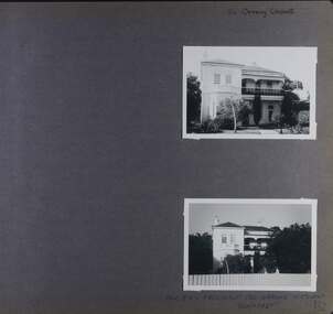 Glen Eira Historical Society
Album - Album page, 84 Orrong Crescent, Circa 1972
... residence of the Boom period. From Victorian Heritage Database citation for HO50 84 Orrong Crescent Caulfield North https://vhd.heritagecouncil.vic.gov.au/places/35584 as at (28/10/2020) An imposing Italianate two storeyed asymmetrical villa with overpainted stuccoed surfaces to the facade, distinguished by their ornate treatment. Unusually rich ornamentation includes the acanthus leaf impost capitals, aedicules with swags and volutes, foliated panels to the frieze, ashlar treatment to the lower level and quoins above. The two storeyed cast iron verandah with timber ...This photograph is part of the Caulfield Historical Album 1972. This album was created in approximately 1972 as part of a project by the Caulfield Historical Society to assist in identifying buildings worthy of preservation. The album is related to a Survey the Caulfield Historical Society developed in collaboration with the National Trust of Australia (Victoria) and Caulfield City Council to identify historic buildings within the City of Caulfield that warranted the protection of a National Trust Classification. Principal photographer thought to be Trevor Hart, member of Caulfield Historical Society. Most photographs were taken between 1966-1972 with a small number of photographs being older and from unknown sources. All photographs are black and white except where stated, with 386 photographs over 198 pages. From Victorian Heritage Database citation for 84 Orrong Crescent https://vhd.heritagecouncil.vic.gov.au/places/35584 as at (28/10/2020) "St. Reliers" at 84 Orrong Crescent is important as an unusually excessively enriched asymmetrical villa residence of the Boom period. From Victorian Heritage Database citation for HO50 84 Orrong Crescent Caulfield North https://vhd.heritagecouncil.vic.gov.au/places/35584 as at (28/10/2020) An imposing Italianate two storeyed asymmetrical villa with overpainted stuccoed surfaces to the facade, distinguished by their ornate treatment. Unusually rich ornamentation includes the acanthus leaf impost capitals, aedicules with swags and volutes, foliated panels to the frieze, ashlar treatment to the lower level and quoins above. The two storeyed cast iron verandah with timber frieze rail protects a black and white tiled floor. The hipped roof has patterned slates.Page 152 of Photograph Album with two landscape photographs of Bonhurst on Orrong Crescent.Handwritten: 84 Orrong Crescent [top right] / NOW 84 - PREVIOUSLY 120 ORRONG CRESCENT / "BONHURST" [under bottom photo] / 152 [bottom right]trevor hart, verandah, porch, slate roof, garden, decorative brackets, fanlight, protruding bay, bay window, garden lamp, asymmetrical, bonhurst, st reliers, rendered, orrong crescent, caulfield north, cast iron work, victorian style, mansions, house names, slate roofs, italianate style -
 Glen Eira Historical Society
Album - Album page, Glenmoore, St George's Road, Circa 1972
... residence in the then fashionable bi-chromatic brick form. It is also important as the home of Hugh Moore who built several shops in nearby Glen Huntly Road and which remain as important contributors to the architectural character of the Elsternwick Shopping Centre. Victorian Heritage Database citation HO59 Glenmoore, 1 St Georges Road Elsternwick https://vhd.heritagecouncil.vic.gov.au/places/35202 An imposing two storeyed villa in bichrome brick with two storeyed timber posted verandah, coupled with cast iron lace frieze, spandrels and central tympanum enrichment. ...This photograph is part of the Caulfield Historical Album 1972. This album was created in approximately 1972 as part of a project by the Caulfield Historical Society to assist in identifying buildings worthy of preservation. The album is related to a Survey the Caulfield Historical Society developed in collaboration with the National Trust of Australia (Victoria) and Caulfield City Council to identify historic buildings within the City of Caulfield that warranted the protection of a National Trust Classification. Principal photographer thought to be Trevor Hart, member of Caulfield Historical Society. Most photographs were taken between 1966-1972 with a small number of photographs being older and from unknown sources. All photographs are black and white except where stated, with 386 photographs over 198 pages. From Victorian Heritage Database citation for HO59 Glenmoore, 1 St Georges Road Elsternwick https://vhd.heritagecouncil.vic.gov.au/places/35202 as at 30/10/2020 "Glenmoore" is locally significant as a surviving mid nineteenth century villa residence in the then fashionable bi-chromatic brick form. It is also important as the home of Hugh Moore who built several shops in nearby Glen Huntly Road and which remain as important contributors to the architectural character of the Elsternwick Shopping Centre.Victorian Heritage Database citation HO59 Glenmoore, 1 St Georges Road Elsternwick https://vhd.heritagecouncil.vic.gov.au/places/35202 An imposing two storeyed villa in bichrome brick with two storeyed timber posted verandah, coupled with cast iron lace frieze, spandrels and central tympanum enrichment. The hipped roof is in slate and has a prominent crean1 brick chimney stack forming part of the facade. Openings are flat arched although the entrance is round arched with a fan light. The south elevation has bayed windows. Two storeyed hip roofed additions are sympathetic and attached on the north side and at the rear. Inside, the staircase and stained glasswork with initials "HM" and family coat of arms are important surviving elements. INTEGRITY: Good, timber outbuildings of an early date, mature and spacious front garden includes early palm trees. Alterations include reconstruction of facade verandah including tiled pavement and front door on east side. Interior has a high level of integrity. Original grounds included adjoining "Carramar".Page 178 of Photograph Album with three photographs of Glenmoore, St Georges Road. Handwritten: "Glenmoore" 1 St George's Road [top right] / 178 [bottom right]trevor hart, chimneys, porch, mansion, slate roof, return verandah, stained glass, cast iron frieze, glenmoore, 1860's, hugh moore, glenmoore estate, double storey, elsternwick shops, st george's road, thomas watts, elsternwick, victorian style, protruding bay windows, cast iron work, bi-chromatic bricks, gardens, balconies, moore's buildings, glen huntly road, stairs, house names