Showing 224 items matching "topographic"
-
 Bendigo Military Museum
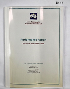
Administrative record - Army Topographic Support Establishment: Performance Report Financial Year 1998 - 1999, 13 Jul 1999
... Army Topographic Support Establishment: Performance Report Financial Year 1998 - 1999...A Report showing numerous charts of production objectives for all types of mapping production conducted by the Army Topographic Support Establishment in the Financial year 1998 - 1999...Army Topographic Support Agency...Army Topographic Support Establishment: Performance Report Financial Year 1998 - 1999 Administrative record Army Topographic Support Establishment: Performance Report Financial Year 1998 - 1999 Army Topographic Support Agency ...A Report showing numerous charts of production objectives for all types of mapping production conducted by the Army Topographic Support Establishment in the Financial year 1998 - 1999A4 size, clear plastic front cover, white plastic back cover, bound with tape. 16 loose pages, 8 x coloured pages showing production rates, 7 x pages roduction summary and RAAF C-130E Hercules replacement programme, 1 x page summarising production.royal australian survey corps, rasvy, fortuna, army survey regiment, army svy regt, asr -
 Sunshine and District Historical Society Incorporated
Map - Sydenham West Topographic Map, Vicmap, 1977
... ... Topographic...Printed topographic map of the Sydenham West region...Sydenham West 7822-4-2 Zone 55 1:25000 1977 Topographic Map...Sydenham West Topographic Club Topographic Map Document Sydenham West 7822-4-2 Zone 55 1:25000 1977 Topographic Map Printed topographic map of the Sydenham West region Map Sydenham West Topographic Map Vicmap ...Sydenham West 7822-4-2 Zone 55 1:25000 1977 Topographic Mapsydenham west topographic club, topographic, map document -
 Stawell Historical Society Inc
Map, Topographic Map Stawell North
... Topographic Map Stawell North...Topographic Map 1:25000 Coloured 1990...Stawell Historical Society Inc 46 Longfield St Stawell grampians Mapping Stawell North 7423-1-N Topographic Map 1:25000 Coloured 1990 Topographic Map Stawell North Map ...Topographic Map 1:25000 Coloured 1990Stawell North 7423-1-Nmapping -
Stawell Historical Society Inc
Map, Topographic Map Stawell South
... Topographic Map Stawell South...Topographic Map 1:25000 Coloured 1990...Stawell Historical Society Inc 46 Longfield St Stawell grampians Mapping Stawell South 7423-1-S Topographic Map 1:25000 Coloured 1990 Topographic Map Stawell South Map ...Topographic Map 1:25000 Coloured 1990Stawell South 7423-1-Smapping -
Stawell Historical Society Inc
Map, Topographic Map Callawadda South
... Topographic Map Callawadda South...Topographic Map 1:25000 Coloured 1990...Stawell Historical Society Inc 46 Longfield St Stawell grampians Mapping Callawadda South 7424-2-S Topographic Map 1:25000 Coloured 1990 Topographic Map Callawadda South Map ...Topographic Map 1:25000 Coloured 1990Callawadda South 7424-2-Smapping -
Stawell Historical Society Inc
Map, Topographic Map Ararat North
... Topographic Map Ararat North...Topographic Map 1:25000 Coloured 1990...Stawell Historical Society Inc 46 Longfield St Stawell grampians Mapping Ararat North 7423-2-N Topographic Map 1:25000 Coloured 1990 Topographic Map Ararat North Map ...Topographic Map 1:25000 Coloured 1990Ararat North 7423-2-Nmapping -
Stawell Historical Society Inc
Map, Topographic Map Glenorchy North
... Topographic Map Glenorchy North...Topographic Map 1:25000 Coloured 1990...Stawell Historical Society Inc 46 Longfield St Stawell grampians Mapping Glenorchy North 7424-3-N Topographic Map 1:25000 Coloured 1990 Topographic Map Glenorchy North Map ...Topographic Map 1:25000 Coloured 1990Glenorchy North 7424-3-Nmapping -
Stawell Historical Society Inc
Map, Victorian Topographic Map Barton
... Victorian Topographic Map Barton...Topographic Map 1:25000 Coloured 1985...Stawell Historical Society Inc 46 Longfield St Stawell grampians Mapping Barton 7423-3-1 Zone 54 VicMap Topographic Map 1:25000 Coloured 1985 Victorian Topographic Map Barton Map ...Topographic Map 1:25000 Coloured 1985Barton 7423-3-1 Zone 54 VicMapmapping -
Stawell Historical Society Inc
Map, Victorian Topographic Map Fyans Creek
... Victorian Topographic Map Fyans Creek...Topographic Map 1:25000 Coloured 1985...Stawell Historical Society Inc 46 Longfield St Stawell grampians Mapping Fyans Creek 7423-4-4 Zone 54 VicMap Topographic Map 1:25000 Coloured 1985 Victorian Topographic Map Fyans Creek Map ...Topographic Map 1:25000 Coloured 1985Fyans Creek 7423-4-4 Zone 54 VicMapmapping -
Stawell Historical Society Inc
Map, Victorian Topographic Map Glenorchy
... Victorian Topographic Map Glenorchy...Topographic Map 1:25000 Coloured 1985...Stawell Historical Society Inc 46 Longfield St Stawell grampians Mapping Glenorchy 7424-3-2 Zone 54 VicMap Topographic Map 1:25000 Coloured 1985 Victorian Topographic Map Glenorchy Map ...Topographic Map 1:25000 Coloured 1985Glenorchy 7424-3-2 Zone 54 VicMapmapping -
Stawell Historical Society Inc
Map, Victorian Topographic Map Ledcourt
... Victorian Topographic Map Ledcourt...Topographic Map 1:25000 Coloured 1985...Stawell Historical Society Inc 46 Longfield St Stawell grampians Mapping Ledcourt 7424-3-3 Zone 54 VicMap Topographic Map 1:25000 Coloured 1985 Victorian Topographic Map Ledcourt Map ...Topographic Map 1:25000 Coloured 1985Ledcourt 7424-3-3 Zone 54 VicMapmapping -
Stawell Historical Society Inc
Map, Victorian Topographic Map Bellellen
... Victorian Topographic Map Bellellen...Topographic Map 1:25000 Coloured 1985...Stawell Historical Society Inc 46 Longfield St Stawell grampians Mapping Bellellen 7423-4-2 Zone 54 VicMap Topographic Map 1:25000 Coloured 1985 Victorian Topographic Map Bellellen Map ...Topographic Map 1:25000 Coloured 1985Bellellen 7423-4-2 Zone 54 VicMapmapping -
Stawell Historical Society Inc
Map, Victorian Topographic Map Illawarra
... Victorian Topographic Map Illawarra...Topographic Map 1:25000 Coloured 1978...Stawell Historical Society Inc 46 Longfield St Stawell grampians Mapping Illawarra 7423-4-1 Topographic Map 1:25000 Coloured 1978 Victorian Topographic Map Illawarra Map ...Topographic Map 1:25000 Coloured 1978Illawarra 7423-4-1mapping -
Stawell Historical Society Inc
Map, Victorian Topographic Map Rupanyup
... Victorian Topographic Map Rupanyup...Topographic Map 1:100000 Coloured 1976...Stawell Historical Society Inc 46 Longfield St Stawell grampians Mapping Rupanyup 7424 Topographic Map 1:100000 Coloured 1976 Victorian Topographic Map Rupanyup Map ...Topographic Map 1:100000 Coloured 1976Rupanyup 7424mapping -
Stawell Historical Society Inc
Map, Victorian Topographic Map Ararat
... Victorian Topographic Map Ararat...Topographic Map 1:100000 Coloured 1966...Stawell Historical Society Inc 46 Longfield St Stawell grampians Mapping Ararat 7423 Topographic Map 1:100000 Coloured 1966 Victorian Topographic Map Ararat Map ...Topographic Map 1:100000 Coloured 1966Ararat 7423mapping -
Victorian Aboriginal Corporation for Languages
Map, Geographic Data Victoria, Vicmap topographic map index as at June 2000, 2000
... Vicmap topographic map index as at June 2000...Index to Vicmap topographic mapping, including 1:25 000 and 1:50 000 topographic maps, and Outdoor leisure series, compiled by the earlier bodies, Survey &? ...Victorian Aboriginal Corporation for Languages 33 Saxon Street Brunswick melbourne Victorian maps topographic maps maps Index to Vicmap topographic mapping, including 1:25 000 and 1:50 000 topographic maps, and Outdoor leisure series, compiled by the earlier bodies, Survey &? ...Index to Vicmap topographic mapping, including 1:25 000 and 1:50 000 topographic maps, and Outdoor leisure series, compiled by the earlier bodies, Survey &? Mapping Victoria, etc. Also indexes Royal Australian Survey Corps' 1:50 000 topographic mapping.mapsvictorian maps, topographic maps -
 Bendigo Military Museum
Photograph - First Topographic Map Printed on Speedmaster Press - Army Survey Regiment, Fortuna, Bendigo, c1992
... First Topographic Map Printed on Speedmaster Press - Army Survey Regiment, Fortuna, Bendigo. ...This is a photograph of the Director Survey - COL Simon Lemon, CO Army Svy Regt - LTCOL Bob McHenry and probably OC Litho - MAJ Terry Lord inspecting the 1St topographic map printed on the new Heidelberg Speedmaster 102 Printing Press in c1992. ...This is a photograph of three senior RASvy officers inspecting the first topographic map printed on the Heidelberg Speedmaster 102 Printing Press in Lithographic Squadron, Army Survey Regiment, Fortuna, Bendigo, c1992. ...Photograph First Topographic Map Printed on Speedmaster Press - Army Survey Regiment, Fortuna, Bendigo. ...This is a photograph of the Director Survey - COL Simon Lemon, CO Army Svy Regt - LTCOL Bob McHenry and probably OC Litho - MAJ Terry Lord inspecting the 1St topographic map printed on the new Heidelberg Speedmaster 102 Printing Press in c1992. *Estimated date based on the Director’s and CO’s period of appointment. The computer-controlled five colour lithographic offset printing press provided the Royal Australian Survey Corps vastly improved printing capability, as the five colours for a standard topographic map was printed in a single pass. The print room was named Wayzgoose Hall after a medieval printing house festival. Wayzgoose Hall and the Speedmaster printing capability was commissioned by the Commander of the 3rd Military District BRIG P. Davies AM, ADC on Wednesday 27th June 1990. This occasion is covered in more detail in page 145 of Valerie Lovejoy’s book 'Mapmakers of Fortuna – A history of the Army Survey Regiment’ ISBN: 0-646-42120-4. Colonel Simon Lemon was Director of the Royal Australian Survey Corps from January 1991 to June 1996.This is a photograph of three senior RASvy officers inspecting the first topographic map printed on the Heidelberg Speedmaster 102 Printing Press in Lithographic Squadron, Army Survey Regiment, Fortuna, Bendigo, c1992. The photograph is on 35mm black and white negative film and was scanned at 96 dpi. It is part of the Army Survey Regiment’s Collection. No personnel are identified. royal australian survey corps, rasvy, army survey regiment, army svy regt, fortuna, asr -
 Bendigo Military Museum
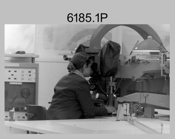
Photograph - Capturing Topographic Features with a Wild B8 – Army Survey Regiment, Fortuna, Bendigo, c1980
... Capturing Topographic Features with a Wild B8 – Army Survey Regiment, Fortuna, Bendigo. ...These four photographs of SPR Santina (Argetto) Straube capturing topographic features – plotting with a Wild B8 stereo plotter were most likely taken in c1980. ...This is a set of four photographs of a technician capturing topographic Features with a Wild B8 stereo plotter in Air Survey Squadron – Army Survey Regiment, Fortuna, Bendigo. 1980. ...Photograph Capturing Topographic Features with a Wild B8 – Army Survey Regiment, Fortuna, Bendigo. ...These four photographs of SPR Santina (Argetto) Straube capturing topographic features – plotting with a Wild B8 stereo plotter were most likely taken in c1980. Introduced in 1966, the Wild B8 stereo plotter was used for plotting topographic detail and contours. These analogue machines were manually controlled by adjusting the control knobs for the orientation of the 3D image. The B8s used a nine-inch square photo image on a film or glass diapositive which allowed highly accurate extraction of map features. At first, plotting by B8 and B9 equipment was undertaken at the aerial photography scale of 1:80,000 in pencil onto a controlled plotting sheet. Sheets were then inked up and reduced photographically to the 1: 100,000 publication scale for scribe impression production. In these photos SPR Santina (Argetto) Straube was plotting with a pencil or ink pen mounted at the far end of the pantograph arm. The plotting procedure was upgraded to direct plotting in ink with photographic reduction to publication scale. In 1975 four B8s were upgraded with tri-axis locaters as part of the Input Sub-system to enable digital extraction to AUTOMAP 1’s topographic database. When AUTOMAP 2 was introduced in 1982 these B8s were upgraded, and additional machines added to expand the Army Survey Regiment’s digital capture capability. This is a set of four photographs of a technician capturing topographic Features with a Wild B8 stereo plotter in Air Survey Squadron – Army Survey Regiment, Fortuna, Bendigo. 1980. The photographs were on 35mm negative film and were scanned at 96 dpi. They are part of the Army Survey Regiment’s Collection. .1) to .4) Photo, black & white, c1980. SPR Santina (Argetto) Straube operating a Wild B8 stereo plotter..1P to .4P – no annotations.royal australian survey corps, rasvy, army survey regiment, army svy regt, fortuna, asr, air survey, photogrammetry -
 Bendigo Military Museum
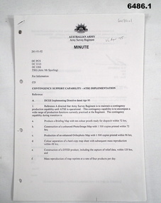
Document - Contingency Support Capability - Army Topographic Support Establishment (ATSE) Implementation, Army Survey Regiment, Bendigo, Apr - Jun 1995
... Contingency Support Capability - Army Topographic Support Establishment (ATSE) Implementation....1 Contingency Support Capability - Army Topographic Support Establishment (ATSE) Implementation 26 Apr 95 (11 x A4 pages) .2 Data Acquisition Squadron (DAS) Contingency Support Capability - Army Topographic Support Establishment (ATSE) Implementation Apr 95 (4 x A4 Pages) .3 Contingency Support Capability - Army Topographic Support Establishment (ATSE) Implementation 28 Apr 95 (9 x A4 pages) .4 Directorate of Military Survey - Army Instruction for Implementation of the Army Topographic Support Establishment (ATSE) Jun 95 (10 x A4 pages)...Royal Australian Survey Corps RASvy Fortuna Army Survey Regiment Army Svy Regt ASR ATSE .1 Contingency Support Capability - Army Topographic Support Establishment (ATSE) Implementation 26 Apr 95 (11 x A4 pages) .2 Data Acquisition Squadron (DAS) Contingency Support Capability - Army Topographic Support Establishment (ATSE) Implementation Apr 95 (4 x A4 Pages) .3 Contingency Support Capability - Army Topographic Support Establishment (ATSE) Implementation 28 Apr 95 (9 x A4 pages) .4 Directorate of Military Survey - Army Instruction for Implementation of the Army Topographic Support Establishment (ATSE) Jun 95 (10 x A4 pages) Contingency Support Capability - Army Topographic Support Establishment (ATSE) Implementation Document Contingency Support Capability - Army Topographic Support Establishment (ATSE) Implementation Army Survey Regiment, Bendigo Directorate of Military Survey, Canberra ....1 The Minute details that the Army Survey Regiment is maintain a contingency production capability until ATSE is operational. .2 The Minute details the Data Aquisition Squadron requirements during the Implementation to ATSE. .3 The Minute details the Hardware, Software, Personnel and skills required during Implementation to ATSE. .4 The Instruction details that the non-core mapping, charting and geodetic (MC&G) activities of the Army Survey Regiment and 4 Fd Svy Sqn were tested under the Commercial Support Program (CSP) process resulting in the decision to award the contract for the provision of non-core mapping services to the ADF to the Preferred In-House Option (PIHO). .1 Contingency Support Capability - Army Topographic Support Establishment (ATSE) Implementation 26 Apr 95 (11 x A4 pages) .2 Data Acquisition Squadron (DAS) Contingency Support Capability - Army Topographic Support Establishment (ATSE) Implementation Apr 95 (4 x A4 Pages) .3 Contingency Support Capability - Army Topographic Support Establishment (ATSE) Implementation 28 Apr 95 (9 x A4 pages) .4 Directorate of Military Survey - Army Instruction for Implementation of the Army Topographic Support Establishment (ATSE) Jun 95 (10 x A4 pages)royal australian survey corps, rasvy, fortuna, army survey regiment, army svy regt, asr, atse -
 Bendigo Military Museum
Album - Photographic Identification Guide (PIG) of the Gove Penisula (Sic) Peninsula, Army Topographic Support Establishment, May 1997
... These photographs and a video were captured in May 1997 by Jeff Ruiz and Wayne Walsh from the Army Topographic Support Establishment (ATSE). The video taken onboard an aircraft has not been located at this time. ...Army Topographic Support Establishment...Photographic Identification Guide (PIG) of the Gove Penisula (Sic) Peninsula Album Photographic Identification Guide (PIG) of the Gove Penisula (Sic) Peninsula Army Topographic Support Establishment ...These photographs and a video were captured in May 1997 by Jeff Ruiz and Wayne Walsh from the Army Topographic Support Establishment (ATSE). The video taken onboard an aircraft has not been located at this time. A flight line diagram showing the path of the aircraft taking the video is enclosed in the album. The Army Topographic Support Establishment was created to perform some of the functions of the Army Survey Regiment.A Large Purple covered Album with gold dots containing maps, plans and coloured photographs of Gove Peninsula.royal australian survey corps, rasvy, fortuna, army survey regiment, army svy regt, asr, atse -
 Bendigo Military Museum
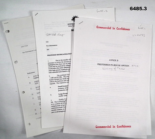
Document - Army Topographic Support Establishment: Preferred In-House Option, 1 23 Nov 1993, .2 30 Nov 1994, .3 14 Jun 1995
... Army Topographic Support Establishment: Preferred In-House Option....1 The Preferred In-House Option (PIHO) proposes to meet the full requirements of the Request for Tender (RFT) by disestablishing Army Survey Regiment and establishing a new organisation which they have named the Defence Topographic Support Establishment (DTSE). It is proposed to locate the DTSE at Bendigo in the GFE facilities offered by the Commonwealth. ....1 Preferred In-House Option, Army Topographic Support Establishment. Summary of Tender. 10 x pages typed text and schematic diagrams. .2 Proposed reorganisation - product Construction Squadron. 9 x pages typed text and schematic diagrams. .3 Implementation of the Commercial Support Program (CSP) Digital Topographical support to the Australian Defence Force (ADF). ...Preferred In-House Option 14 Jun 1995. 22 x pages typed text and schematic diagrams. Army Topographic Support Establishment: Preferred In-House Option Document Army Topographic Support Establishment: Preferred In-House Option ....1 The Preferred In-House Option (PIHO) proposes to meet the full requirements of the Request for Tender (RFT) by disestablishing Army Survey Regiment and establishing a new organisation which they have named the Defence Topographic Support Establishment (DTSE). It is proposed to locate the DTSE at Bendigo in the GFE facilities offered by the Commonwealth. The DTSE will be staffed by 140 Defence civilians, principally sourced from ex-RASvy members transferring to the Public Service under the provisions of Section 81B of the Public Service Act. Any existing civilian members excess to DTSE requirements are proposed to be managed within the terms and conditions of the Australian Public Service Redeployment and Retirement (Redundancy) Award 1987. Military members who elect to remain in the Service will be subject to redeployment or retraining in accordance with Service requirements. .2 Proposed re-organisation of Product Construction Squadron (PCS). Due to the transfer of Image and capture Sections to Digital Acquisition Squadron wef Jan 1995 it has been necessary to review the structure of those elements remaining within PCS. The review highlighted that there was an imbalance between Mapping and Digital products Troops. This could only be resolved by collapsing these two Troops into one single production element. This would halve the senior administrative personnel needed thus allowing them to be employed in other higher priority technical areas. The proposed restructure of PCS is outlined in Annex A with redundant personnel listed in Annex B. The combined Troop is to be designated "Construction Troop" and comprises 1 Offr and 69 ORs. The role of this Tp would be to perform all digital production. It is further divided into small and Large Format Sections. This division is functionally based and reflects the hardware and software configurations now resident within the Sqn post system upgrade. .3 During the transition period leading to full implementation of the PHIO, the Army Svy Regt and DTSE (later ATSE) will at times operate concurrently whilst Army Svy Regt scales down production and progressively transfers all technical functions to DTSE. army Svy Regt and 4 Fd Svy Sqn will continue programmed production activities until declared operationally ineffective, however a contingency mapping capability will be maintained throughout the period of implementation. Implementation of the PHIO involves a number of related activities including staff recruitment, equipment acquisition and transfer of technical responsibility. This instruction details the coordination of these and related implementation activities. .1 Preferred In-House Option, Army Topographic Support Establishment. Summary of Tender. 10 x pages typed text and schematic diagrams. .2 Proposed reorganisation - product Construction Squadron. 9 x pages typed text and schematic diagrams. .3 Implementation of the Commercial Support Program (CSP) Digital Topographical support to the Australian Defence Force (ADF). Preferred In-House Option 14 Jun 1995. 22 x pages typed text and schematic diagrams. royal australian survey corps, rasvy, fortuna, army svy reg, army survey regiment, atse -
 Bendigo Military Museum
Photograph - Capturing Topographic Features with a Wild B8, AUTOMAP 1 Systems Operations – Army Survey Regiment, Fortuna, Bendigo, 1980
... Capturing Topographic Features with a Wild B8, AUTOMAP 1 Systems Operations – Army Survey Regiment, Fortuna, Bendigo...This is a set of 24 photographs of Air Survey Squadron technicians capturing topographic Features with a Wild B8 stereo plotter and operating AUTOMAP 1 equipment at the Army Survey Regiment at Fortuna, Bendigo, 1980. 17 of these photographs were taken of SPR Nick Van Dalen and SPR Santina (Argetto) Straube capturing topographic features – plotting with a Wild B8 stereo plotter were most likely taken in 1980. ...This is a set of 24 photographs of Air Survey Squadron technicians capturing topographic features with a Wild B8 stereo plotter and operating AUTOMAP 1 equipment at the Army Survey Regiment at Fortuna, Bendigo, c1980. ...CPL Gerry Gunn undertaking AUTOMAP 1 computer system duties. Capturing Topographic Features with a Wild B8, AUTOMAP 1 Systems Operations – Army Survey Regiment, Fortuna, Bendigo Photograph Capturing Topographic Features with a Wild B8, AUTOMAP 1 Systems Operations – Army Survey Regiment, Fortuna, Bendigo Army Survey Regiment ...This is a set of 24 photographs of Air Survey Squadron technicians capturing topographic Features with a Wild B8 stereo plotter and operating AUTOMAP 1 equipment at the Army Survey Regiment at Fortuna, Bendigo, 1980. 17 of these photographs were taken of SPR Nick Van Dalen and SPR Santina (Argetto) Straube capturing topographic features – plotting with a Wild B8 stereo plotter were most likely taken in 1980. See item 6185.4P for black & white copies of photos of SPR Santina (Argetto) Straube operating the Wild B8 stereo plotter. Refer to item 6204.8P for detailed information and additional photographs of the Wild B8 stereo plotter. The history of the AUTOMAP 1 system is covered in more detail with additional historic photographs in pages 116-118 of Valerie Lovejoy’s book 'Mapmakers of Fortuna – A history of the Army Survey Regiment’ ISBN: 0-646-42120-4. See items 6122.20P, 6183.19P, 6184.20P, 6200.5P, and 6222.17P for additional photographs of the AUTOMAP 1 system.This is a set of 24 photographs of Air Survey Squadron technicians capturing topographic features with a Wild B8 stereo plotter and operating AUTOMAP 1 equipment at the Army Survey Regiment at Fortuna, Bendigo, c1980. The photographic proofs were printed on photographic paper and are part of the Army Survey Regiment’s Collection. The photographic proof prints were scanned at 600 dpi. .1) to .8) Photo, black & white, 1980. SPR Santina (Argetto) Straube operating a Wild B8 stereo plotter. .9) to .17) Photo, black & white, 1980. SPR Nick Van Dalen operating a Wild B8 stereo plotter. .18) to .24) Photo, black & white, 1980. CPL Gerry Gunn undertaking AUTOMAP 1 computer system duties..1P to .24P – no annotations.automap 1, royal australian survey corps, rasvy, army survey regiment, army svy regt, fortuna, asr, photogrammetry -
 Bendigo Military Museum
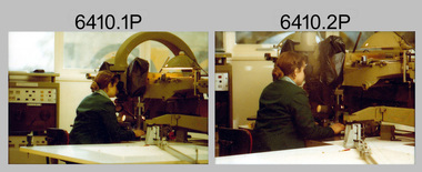
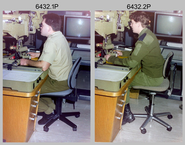
Photograph - Capturing Topographic Features with a Wild B8, AUTOMAP 2 Systems Operations – Army Survey Regiment, Fortuna, Bendigo, 1990
... Capturing Topographic Features with a Wild B8, AUTOMAP 2 Systems Operations – Army Survey Regiment, Fortuna, Bendigo...This is a set of two photographs of Air Survey Squadron technicians - LCPL Peter Murphy and SPR Rachel (Stanford) Scott capturing topographic features with a Wild B8 stereo plotter with AUTOMAP 2 equipment at the Army Survey Regiment, Fortuna, Bendigo, c1990. ...This is a set of two photographs of Air Survey Squadron technicians capturing topographic features with a Wild B8 stereo plotter with AUTOMAP 2 equipment at the Army Survey Regiment at Fortuna, Bendigo, c1990. ...SPR Rachel (Stanford) Scott operating a Wild B8 stereo plotter. Capturing Topographic Features with a Wild B8, AUTOMAP 2 Systems Operations – Army Survey Regiment, Fortuna, Bendigo Photograph Capturing Topographic Features with a Wild B8, AUTOMAP 2 Systems Operations – Army Survey Regiment, Fortuna, Bendigo Army Survey Regiment ...This is a set of two photographs of Air Survey Squadron technicians - LCPL Peter Murphy and SPR Rachel (Stanford) Scott capturing topographic features with a Wild B8 stereo plotter with AUTOMAP 2 equipment at the Army Survey Regiment, Fortuna, Bendigo, c1990. Refer to item 6185.4P and 6204.8P for detailed information and additional photographs of the Wild B8 stereo plotter. The history of the AUTOMAP 2 system is covered in more detail with additional historic photographs in pages 119, 137-142 and 180 of Valerie Lovejoy’s book 'Mapmakers of Fortuna – A history of the Army Survey Regiment’ ISBN 0-646-4: 2120-4. See items 6087.10P and 6223.23P for additional photographs of the AUTOMAP 2 system.This is a set of two photographs of Air Survey Squadron technicians capturing topographic features with a Wild B8 stereo plotter with AUTOMAP 2 equipment at the Army Survey Regiment at Fortuna, Bendigo, c1990. The photographs are on 35mm negative film. They are part of the Army Survey Regiment’s Collection. The photographic negatives were scanned at 96 dpi. .1) - Photo, colour, 1990. LCPL Peter Murphy operating a Wild B8 stereo plotter. .2) - Photo, colour, 1990. SPR Rachel (Stanford) Scott operating a Wild B8 stereo plotter..1P to .2P – no annotationsroyal australian survey corps, rasvy, army survey regiment, army svy regt, fortuna, asr, photogrammetry -
 Bendigo Military Museum
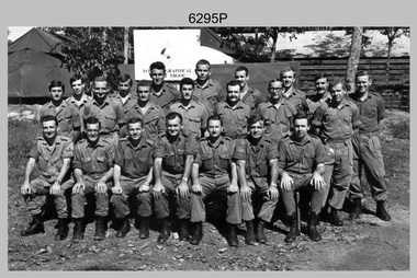
Photograph - A Section, 1st Topographic Survey Troop, Nui Dat, Vietnam, 1969
... A Section, 1st Topographic Survey Troop, Nui Dat, Vietnam...This is a photograph of A Section, 1st Topographic Survey Troop taken at Nui Dat, Vietnam in 1969. ...This is a photograph of A Section, 1st Topographic Survey Troop taken at Nui Dat, Vietnam in 1969. ...A Section, 1st Topographic Survey Troop, Nui Dat, Vietnam Photograph A Section, 1st Topographic Survey Troop, Nui Dat, Vietnam Army Survey Regiment ...This is a photograph of A Section, 1st Topographic Survey Troop taken at Nui Dat, Vietnam in 1969. A nominal roll of personnel and their trade as of the 30th of September 1969, accompanies this photo. Their trades in this photo were as follows - Surveyors Topographic: WO1 Darby Munro, SGT Paddy Strunks, SGT Graeme Birrell, CPL Brian Knight, CPL Colin Laybutt, SPR Roderick Gilbert and SPR Rodney Offer. Draughtsmen Topographic: SGT Terrance Linz, CPL Robert Kay, SPR Peter Aukstinaitis, SPR Lloyd Patterson and SPR Ian Wark. Photographer Cartographic: CPL George Graham. Clerk Admin: CPL Oreste Biziak. Helioworker: CPL Geoffrey White, SPR Lance Percey. Cook AACC: PTE R. Johnston. The first Royal Australian Survey Corps troops arrived in South Vietnam on the 10th of June 1966. This was a detachment from 1st Topographic Survey Troop, which was to give cartographic support to the Australian Task Force. Their main tasks were to establish a Theatre Grid, map compilation and map revision. Engineer Survey Support in the camp and to the civil community and give assistance to the Cordon Search Missions by producing large scale plots from aerial photos with every house and fence etc plotted and then reproduce these by silk screening usually, within a 24-hour period. This support concluded with the withdrawal of Australian troops from Vietnam in 1972. For more information on the career of A Section’s OC MAJ Peter Constantine AM, refer to item 6159P or 6092P. He was the CO of the Army Survey Regiment from 1975 to 1976 and CO of the School of Military Survey (SMS) from 1976 to his retirement in January 1982. His memoirs of active duty in Vietnam ‘Surveyor - Printer Behind the Lines’ was published in 2022. 2IC CAPT Frank Thorogood SB St J’s career culminated at the rank of LTCOL as the CO Army Survey Regiment from 1980 to 1981. More information on the A Section, 1st Topographic Survey Troop and the Army Survey Regiment’s supporting role is provided in pages 89 to 94 of Valerie Lovejoy’s book 'Mapmakers of Fortuna – A history of the Army Survey Regiment’ ISBN: 0-646-42120-4.This is a photograph of A Section, 1st Topographic Survey Troop taken at Nui Dat, Vietnam in 1969. The black and white photograph was printed on photographic paper and is part of the Army Survey Regiment’s Collection. The photograph was scanned at 300 dpi. .1) - Photo, black & white, 1969. Back row L to R: SPR Lance Percey, SPR Bruce Grisdale, SPR Rodney Offer, SPR Roderick Gilbert, CPL Geoffrey White, PTE R. Johnston, CPL Colin Laybutt, SPR Lloyd Patterson. Centre row L to R: SPR Peter Aukstinaitis, SPR Ian Hanna, SPR Ian Wark, CPL Robert Kay, CPL George Graham, CPL Oreste Biziak, CPL Brian Knight. Front row L to R: SGT Terrance Linz, SSGT Gordon Haswell, 2IC CAPT Frank Thorogood SB St J, OC MAJ Peter Constantine AM, WO1 Darby Munro, SGT Paddy Strunks, SGT Graeme Birrell.An A4 nominal roll of personnel and their trade accompanies the photo, as of the 30th of September 1969. A torn paper identifies the personnel in the photo. Annotated on back of photo – ‘Unit Photo – 1 Topo Svy Tp 30 Sept 69’royal australian survey corps, rasvy, army survey regiment, army svy regt, fortuna, asr -
 Bendigo Military Museum
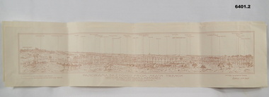
Map - Panorama sketch from Heath Trench Sector Factory Farm to Messines, 11 April 1917
... Panoramic sketch by George W Bleach A 2nd Anzac Topographical Section. April 11th 1917. View from Heath Trench. ...By George W Bleach A 2nd Anzac Topographical Section. April 11th 1917.... George W Bleach A 2nd Anzac Topographical Section. April 11th 1917....Co-ords of O.P.U13.b 30.20 Panoramic view of Messines George W Bleach A 2nd Anzac Topographical Section. April 11th 1917. Panoramic view of Messines. ...Panoramic sketch by George W Bleach A 2nd Anzac Topographical Section. April 11th 1917. View from Heath Trench. Co-ords of O.P.U13.b 30.20Panoramic view of Messines. Printed on cream card. Sepia image. By George W Bleach A 2nd Anzac Topographical Section. April 11th 1917. George W Bleach A 2nd Anzac Topographical Section. April 11th 1917.panoramic view of messines -
 Bendigo Military Museum
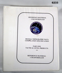
Manual - Digital Topographic Data Compilation Specification - Part 1 Tactical Level Products, February 1995
... Digital Topographic Data Compilation Specification - Part 1 Tactical Level Products...These specifications enable the compilation of digital topographic data for the Australian Defence Force (ADF) to support the production of topographic information across a multiple product range covering Australia and its Area of Direct Military Interest (ADMI)...Bendigo Military Museum 37 - 39 Pall Mall Bendigo goldfields These specifications enable the compilation of digital topographic data for the Australian Defence Force (ADF) to support the production of topographic information across a multiple product range covering Australia and its Area of Direct Military Interest (ADMI) Royal Australian Survey Corps RASvy Fortuna Army Survey Regiment Army Svy Regt ASR Director of Survey-Army A plastic covered four ring folder containing A4 paper, white, ten chapters, metal clip rings Digital Topographic Data Compilation Specification - Part 1 Tactical Level Products Manual Digital Topographic Data Compilation Specification - Part 1 Tactical Level Products Director of Survey - Army ...These specifications enable the compilation of digital topographic data for the Australian Defence Force (ADF) to support the production of topographic information across a multiple product range covering Australia and its Area of Direct Military Interest (ADMI)A plastic covered four ring folder containing A4 paper, white, ten chapters, metal clip ringsroyal australian survey corps, rasvy, fortuna, army survey regiment, army svy regt, asr, director of survey-army -
 Bendigo Military Museum
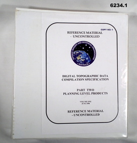
Manual - Digital Topographic Data Compilation Specification - Part 2 Planning Level Products, June 1998
... Digital Topographic Data Compilation Specification - Part 2 Planning Level Products...The purpose of this document is to provide digital Topographic data compilation specifications for the Australian Defence Force (ADF) which are applicable to all areas of the Area of Direct Military Interest (ADMI) for the collection of features and attributes to populate the ADF topographic database....Bendigo Military Museum 37 - 39 Pall Mall Bendigo goldfields The purpose of this document is to provide digital Topographic data compilation specifications for the Australian Defence Force (ADF) which are applicable to all areas of the Area of Direct Military Interest (ADMI) for the collection of features and attributes to populate the ADF topographic database. ...The purpose of this document is to provide digital Topographic data compilation specifications for the Australian Defence Force (ADF) which are applicable to all areas of the Area of Direct Military Interest (ADMI) for the collection of features and attributes to populate the ADF topographic database.6234.1 A four ringed Folder containing A4 Paper, White, Metal Bindings, Chapters 1 to 8 6234.2 A four ringed Folder containing A4 Paper, White, Metal Bindings, Chapters 8 to 13 and Annexesroyal australian survey corps, rasvy, fortuna, army survey regiment, army svy regt, asr, director of survey - army -
 Bendigo Military Museum
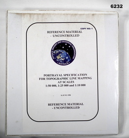
Manual - Portrayal Specification for Topographic Line Mapping at Scales1:50,000, 1:25,000 and 1:10,000, 16.07.1998
... Portrayal Specification for Topographic Line Mapping at Scales1:50,000, 1:25,000 and 1:10,000...These specifications enabled the hard copy representation of digital topographic data for the Australian Defence Force (ADF) covering Australia and nearer regions....Royal Australian Survey Corps RASvy Fortuna Army Survey Regiment Army Svy Regt ASR Director of Strategic Military Geographic Information DSMGI Plastic covered white four ring binder, 14 Chapters, 4 Annexes Portrayal Specification for Topographic Line Mapping at Scales1:50,000, 1:25,000 and 1:10,000 Manual Portrayal Specification for Topographic Line Mapping at Scales1:50,000, 1:25,000 and 1:10,000 DSMGI ...These specifications enabled the hard copy representation of digital topographic data for the Australian Defence Force (ADF) covering Australia and nearer regions.Plastic covered white four ring binder, 14 Chapters, 4 Annexesroyal australian survey corps, rasvy, fortuna, army survey regiment, army svy regt, asr, director of strategic military geographic information, dsmgi -
 Greensborough Historical Society
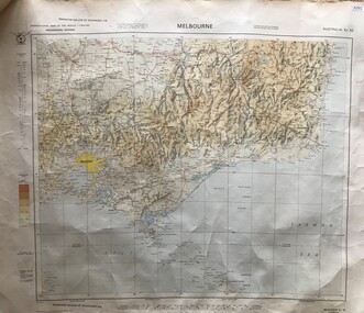
Map, Australia. Department of Minerals and Energy, Melbourne, topographic map, 1970_
... Melbourne, topographic map...A topographic map of Victoria with Melbourne as the centre. ...Greensborough Historical Society 34A Glenauburn Road Lower Plenty Lower Plenty melbourne A topographic map of Victoria with Melbourne as the centre. ...A topographic map of Victoria with Melbourne as the centre. Provisional edition showing contours in feet. International map of the world [scale] 1:1,000,000. Prepared by the Department of Minerals and Energy, Canberra in 1970.A pre-metric map, shows the Hume Highway travelling through towns such as Seymour and Benalla, now by-passed by the Hume Freeway.Map, printed in colour on one side.victoria - maps -
 Bendigo Military Museum
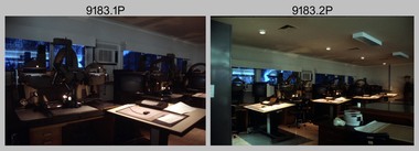
Photograph - AUTOMAP 2 Production and Digital Topographic Data - Army Survey Regiment, Fortuna, Bendigo, c1990
... AUTOMAP 2 Production and Digital Topographic Data - Army Survey Regiment, Fortuna, Bendigo...Refer to Item 6223.23P for more photos of the AUTOMAP 2 System and examples of topographic digital data. Additional information on topographic digital data and its use in military operations is provided in the video included in Item 6010 titled An Introduction to Topographic Mapping circa 1991....Refer to Item 6223.23P for more photos of the AUTOMAP 2 System and examples of topographic digital data. Additional information on topographic digital data and its use in military operations is provided in the video included in Item 6010 titled An Introduction to Topographic Mapping circa 1991. ...This collection of 16 photos of map production on the AUTOMAP 2 computer-based system in Air Survey and Cartographic Squadrons, was most likely taken in 1990. The AUTOMAP 2 system was an upgrade to the AUTOMAP 1 system, comprising Intergraph graphic edit workstation terminals networked to VAX 750/785 main frame computers. Unlike AUTOMAP 1, operators could display digital topographic features on monitors for editing. Successful adaptation of this system meant RASvy was at the forefront of digital mapping/cartographic systems in Australia and overseas. The system comprised Input (Wild B8 Aviograph feature extraction) Raster Scanning (digitising from compilation sheets, Graphic Edit (cartographic completion) and Plot Verification Sub Systems. The system was operational from 1984 to its ‘Newheart’ upgrade in 1993. Throughout its life, the system was progressively refined with productivity gains, achieved from award winning technical development in-house by talented and innovative Army Survey Regiment personnel. Refer to Item 6223.23P for more photos of the AUTOMAP 2 System and examples of topographic digital data. Additional information on topographic digital data and its use in military operations is provided in the video included in Item 6010 titled An Introduction to Topographic Mapping circa 1991.This is a set of 16 photograph of AUTOMAP 2 production at the Army Survey Regiment at Fortuna, Bendigo, c1990. The photographs are on 35mm colour positive film and scanned at 2400 dpi. They are part of the Army Survey Regiment’s Collection. .1) - Photo, colour, c1990, AUTOMAP 2 Wild B8 Aviograph stereoplotter. .2) - Photo, colour, c1990, Four Wild B8 Aviograph stereoplotters, data storage tapes in foreground. .3) - Photo, colour, c1990, AUTOMAP 2 Graphic Edit Workstation. .4) - Photo, colour, c1990, AUTOMAP 2 - cultural digital data. .5) - Photo, colour, c1990, AUTOMAP 2 - drainage and cultural digital data. .6) - Photo, colour, c1990, AUTOMAP 2 - drainage and cultural digital data, enlargement of previous view. .7) - Photo, colour, c1990, AUTOMAP 2 - contour digital data. .8) - Photo, colour, c1990, AUTOMAP 2 - contour digital data with coloured elevation tints. .9) & .10) - Photo, colour, c1990, AUTOMAP 2 - perspective view of 3D digital terrain model. .11) & .12) - Photo, colour, c1990, AUTOMAP 2 – low profile view of 3D digital terrain model. .13) & .14) - Photo, colour, c1990, AUTOMAP 2 – line of sight view sheds from defined point. .15) & .16) - Photo, colour, c1990, AUTOMAP 2 – analytical hill shading samples generated from 3D digital terrain model.There are no annotations.royal australian survey corps, rasvy, army survey regiment, army svy regt, fortuna, automap 2