Showing 493 items matching "topography"
-
 Bendigo Military Museum
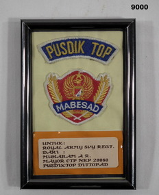
Souvenir - Pusdik Top-Topography Education and Training Centre Mabesad - Army Headquarters (Indonesia), Topography Education and Training Centre, September 1992
... Pusdik Top-Topography Education and Training Centre Mabesad - Army Headquarters (Indonesia)...Souvenir artefact presented to the Army Survey Regiment by a visiting member of the Indonesian Topography Education and Training Centre....Topography Education and Training Centre...Paper label with text. Pusdik Top-Topography Education and Training Centre Mabesad - Army Headquarters (Indonesia) Souvenir Pusdik Top-Topography Education and Training Centre Mabesad - Army Headquarters (Indonesia) Topography Education and Training Centre ...Souvenir artefact presented to the Army Survey Regiment by a visiting member of the Indonesian Topography Education and Training Centre.A framed artefact with Indonesian cloth badge and writing. Paper label with text.royal australian survey corps, rasvy, army survey regiment, army svy regt -
 National Vietnam Veterans Museum (NVVM)
Document, General Topography and Terrain Introduction, 1/06/1964 12:00:00 AM
... General Topography and Terrain Introduction...Thirteen page typed document on the SE Asia generl topography and terrain...Thirteen page typed document on the SE Asia generl topography and terrain General Topography and Terrain Introduction Document Document ...yellowing paper. Thirteen page typed document on the SE Asia generl topography and terraindocument, south east asia, army intelligence centre -
 Federation University Historical Collection
Book, W.M. Gillespie, A Treatise on Levelling, Topography and Higher Surveying, 1884
... A Treatise on Levelling, Topography and Higher Surveying. ......topography...A Treatise on Levelling, Topography and Higher Surveying. Book W.M. Gillespie D. ...Black/blue cloth hard cover of 173 pages. surveying, topography, levelling, w.m. gillespie -
 Eltham District Historical Society Inc
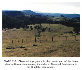
Work on paper (Sub-Item) - Photograph, Dissected topography in the central part of the Diamond Creek basin. View looking upstream along the valley of Diamond Creek towards the Kinglake escarpment
... Dissected topography in the central part of the Diamond Creek basin. ...Eltham District Historical Society Inc 728 Main Rd Eltham melbourne Kinglake escarpment Image printed on A4 page from 04997 Diamond Creek Basin Study, 1980 Dissected topography in the central part of the Diamond Creek basin. ...kinglake, escarpment -
Lakes Entrance Historical Society
Book, Calder Stuart and Winty, Lake Bunga Foreshore Reserve its life and Landscape, 1985
... Topography...A study of the topography, vegetation and fauna of the Lake Bunga Victoria area, and relationship with the coastal environment. ...Lakes Entrance Historical Society 4 Marine Parade Lakes Entrance gippsland Topography Vegetation Natural History A study of the topography, vegetation and fauna of the Lake Bunga Victoria area, and relationship with the coastal environment. ...A study of the topography, vegetation and fauna of the Lake Bunga Victoria area, and relationship with the coastal environment. Revised edition 1985topography, vegetation, natural history -
Lakes Entrance Historical Society
Book, Hurley, P. J, In Search of Australia, 1945
... Topography...An introduction to the historical background of Australia, including human inhabitants, flora, fauna, topography, industries, cities and towns. Historic indicator of the attitudes of the 1940 era....Lakes Entrance Historical Society 4 Marine Parade Lakes Entrance gippsland Topography Natural History Agriculture To Ruth with Love from Mum & Dad Christmas 1945 An introduction to the historical background of Australia, including human inhabitants, flora, fauna, topography, industries, cities and towns. ...An introduction to the historical background of Australia, including human inhabitants, flora, fauna, topography, industries, cities and towns. Historic indicator of the attitudes of the 1940 era.To Ruth with Love from Mum & Dad Christmas 1945topography, natural history, agriculture -
Whitehorse Historical Society Inc.
Map, Nunawading, 1966
... Nunawading's boundaries, schools, topography and railways...Whitehorse Historical Society Inc. 2-10 Deep Creek Road Mitcham melbourne Maps City of Nunawading Schools Nunawading's boundaries, schools, topography and railways Nunawading's boundaries, schools, topography and railways Nunawading Map Map ...Nunawading's boundaries, schools, topography and railwaysNunawading's boundaries, schools, topography and railwaysNunawading's boundaries, schools, topography and railwaysmaps, city of nunawading, schools -
 Federation University Historical Collection
Plan, Mount Helen Campus
... Sketches of the Mount Helen campus, including topography....Barker Library (top floor) Mount Helen goldfields mount helen campus architectural drawings Sketches of the Mount Helen campus, including topography. Mount Helen Campus Plan Plan ...Sketches of the Mount Helen campus, including topography.mount helen campus, architectural drawings -
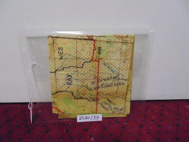 National Vietnam Veterans Museum (NVVM)
Map
... A laminated coloured military map showing topography of areas around Nui Dat with divisional sections hand drawn in black....National Vietnam Veterans Museum (NVVM) 25 Veterans Drive Newhaven phillip-island-and-the-bass-coast Map Nui Dat McPhail Collection A laminated coloured military map showing topography of areas around Nui Dat with divisional sections hand drawn in black. ...A laminated coloured military map showing topography of areas around Nui Dat with divisional sections hand drawn in black.map, nui dat, mcphail collection -
 Bendigo Military Museum
Book - Military Sketching and Reconnaissance, Muckler Ferryman, Royal Military College, Sandhurst, UK, 1903
... Lieut -Col AF Mockler - Ferryman, Late professor of Military Topography, Royal Military College, Sandhurst...Bendigo Military Museum 37 - 39 Pall Mall Bendigo goldfields British Military method of compiling field sheets for mapping purposes Royal Australian Survey Corps RASvy Fortuna Army Survey Regiment Army Svy Regt ASR Lieut -Col AF Mockler - Ferryman, Late professor of Military Topography, Royal Military College, Sandhurst Red Hard covered book, rider and horse on cover, 203 pages, 17 chapters, 4 Appendices, 57 Illustrations. ...British Military method of compiling field sheets for mapping purposesRed Hard covered book, rider and horse on cover, 203 pages, 17 chapters, 4 Appendices, 57 Illustrations.Lieut -Col AF Mockler - Ferryman, Late professor of Military Topography, Royal Military College, Sandhurstroyal australian survey corps, rasvy, fortuna, army survey regiment, army svy regt, asr -
 Phillip Island and District Historical Society Inc.
Map, Map of Summerland Golf Course, 15/12/1927
... Purple leather covered fold out linen map with hand drawn diagram of the topography, layout of golf holes and club house ...Russell 12/12/1927 Purple leather covered fold out linen map with hand drawn diagram of the topography, layout of golf holes and club house Map of Summerland Golf Course Map ...Summerland Estate was created in the 1920s by A.K. T. Sampbell. It consisted of a housing estate, guest house and golf course. This area was acquired and all buildings, roads etc removed by the Victorian Government in the 1980s for a nature reserve for the penguins. This is believed to be the only time in the world when humans have been removed to benefit nature. HistoricalPurple leather covered fold out linen map with hand drawn diagram of the topography, layout of golf holes and club house Broken sand dunes, rough sandy hills, grassy hills and mounds, Swan Lake, Par for nine holes 34, Scratch score for nine holes 36, Drawn by A. Russell 12/12/1927summerland estate, a.k. t. sampbell, map, penguin reserve, summerland golf course -
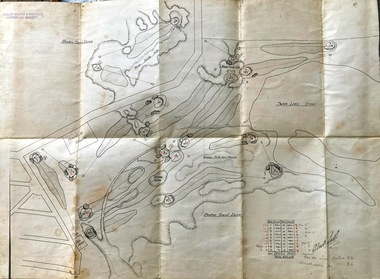
 Coal Creek Community Park & Museum
Mine Cross Sections
... 8520.1 - Diagram of 6 cross-section of the Korumburra coal mine area, showing topography, elevation, faults, coal seams and boreholes....Coal Creek Community Park & Museum 12 Silkstone Road Korumburra gippsland 8520.1 - Diagram of 6 cross-section of the Korumburra coal mine area, showing topography, elevation, faults, coal seams and boreholes. ...8520.1 - Diagram of 6 cross-section of the Korumburra coal mine area, showing topography, elevation, faults, coal seams and boreholes. -
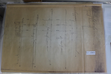
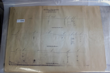 Coal Creek Community Park & Museum
Mine Map
... 6302.1 - 3 cross sections through the Korumburra coal field area, showing topography, surface features, boreholes and elevation. ...Coal Creek Community Park & Museum 12 Silkstone Road Korumburra gippsland 6302.1 - 3 cross sections through the Korumburra coal field area, showing topography, surface features, boreholes and elevation. ...6302.1 - 3 cross sections through the Korumburra coal field area, showing topography, surface features, boreholes and elevation. Seems to be a copy of original. -
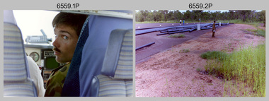 Bendigo Military Museum
Photograph - 4th Field Survey Squadron – Operation MIZMAZE 92, Kimberley region, Western Australia, 1992
... Kimberley region topography. .19) - Photo, colour, 1992. Kimberley region topography. ...Kimberley region topography. .19) - Photo, colour, 1992. Kimberley region topography. ...This is a set of 40 photographs taken in 1992 during 4th Field Survey Squadron’s deployment on Operation MIZMAZE 92 in the Kimberley region of Western Australia from the 13th of May to the 14th of July 1992. The area of operations was Wyndham, Halls Creek and Sandfire Flat. It was a two-part operation involving the field completion of topographic maps and the acquisition of mapping control by GPS field parties utilising Texas Instruments TI4100 Global Positioning System receivers. Survey parties conducted field checking of topographic maps and GPS control acquisition in Perentie 110 Series Survey variant FFR Land Rovers. Three Bell Kiowa LOH helicopters provided by 162 Recce Sqn supported field checking and limited deployment of GPS surveys parties. C-l30 Hercules from 36 Sqn supported deployment and extraction of personnel and equipment to and from from the AO. A Cessna 404 Titan Ambassador from Vee-H Aviation was used as the Wild RC10 camera platform for aerial photography acquisition.This is a set of 40 photographs taken in 1992 during 4th Field Survey Squadron’s deployment on Operation MIZMAZE 92 in the Kimberley region of Western Australia. The colour photographs are on 35mm negative film and are part of the Army Survey Regiment’s Collection. The photographs were scanned at 96 dpi. .1) - Photo, colour, 1992. CAPT Craig Hersant. .2) - Photo, colour, 1992. Unidentified officer/soldier. .3) & .4) - Photo, colour, 1992. Aboriginal rock art - Wandjina Gunduran, Donkey Creek. .5) - Photo, colour, 1992. Aboriginal rock art - Track Wandjinas, Donkey Creek. .6) & .7) - Photo, colour, 1992. CAPT Craig Hersant. .8) - Photo, colour, 1992. Kimberley region topography. CPL Glen Weatherell. .9) - Photo, colour, 1992. Unidentified personnel .10) - Photo, colour, 1992. Supermarket at unknown location. .11) to .13) - Photo, colour, 1992. Caravan park at unknown location. .14) - Photo, colour, 1992. Old bridge at Fitzroy Crosssing. .15) & .16) - Photo, colour, 1992. Survey party in Perentie 110 Series Land Rover. .17) & .18) - Photo, colour, 1992. Kimberley region topography. .19) - Photo, colour, 1992. Kimberley region topography. CPL Glen Weatherell. .20) - Photo, colour, 1992. Kimberley region topography, possibly the Bungle Bungles. .21) - Photo, colour, 1992. Kimberley region topography. SGT Frank Downie. .22) - Photo, colour, 1992. Kimberley region topography: the Bungle Bungles. .23) - Photo, colour, 1992. Kimberley region topography: the Bungle Bungles. .24) - Photo, colour, 1992. Kimberley region topography: the Bungle Bungles. SPR Neil Pedler. .25) & .26) - Photo, colour, 1992. Kimberley region topography: the Bungle Bungles. .27) - Photo, colour, 1992. Kimberley region topography. .28) - Photo, colour, 1992. Survey party with Perentie 110 Series Land Rover. .29) - Photo, colour, 1992. Kimberley region topography. .30) - Photo, colour, 1992. Survey party outside Perentie 110 Series Land Rover. .31) & .32) - Photo, colour, 1992. Survey party operating TI4100 GPS Receiver next to Perentie 110 Series Land Rover. SGT Eddie Jacobs. .33) & .34) - Photo, colour, 1992. Survey party operating TI4100 GPS Receiver next to Perentie 110 Series Land Rover. Unidentified surveyor. .35) - Photo, colour, 1992. Kimberley region topography. Hand water pump at well. .36) - Photo, colour, 1992. Survey party in Perentie 110 Series Land Rover. .37) - Photo, colour, 1992. Kimberley region topography. CPL Glen Weatherell. .38) - Photo, colour, 1992. Kimberley region topography viewed from Bell Kiowa LOH helicopter. .39) & .40) - Photo, colour, 1992. Unidentified surveyor field checking a preliminary map in a Bell Kiowa LOH helicopter..1P to .40P – There are no personnel identified. ‘1992 OP MIZMAZE annotated on negative sleeve.royal australian survey corps, rasvy, 4 fd svy sqn, op mizmaze 92 -
 Coal Creek Community Park & Museum
Mine Map
... 6303.1 - Cross sections of Korumburra coal mining area detailing local faulting and seam location/depth, boreholes, as well as elevation & surface topography along lines of sections....Coal Creek Community Park & Museum 12 Silkstone Road Korumburra gippsland 6303.1 - Cross sections of Korumburra coal mining area detailing local faulting and seam location/depth, boreholes, as well as elevation & surface topography along lines of sections. Mine Map ...6303.1 - Cross sections of Korumburra coal mining area detailing local faulting and seam location/depth, boreholes, as well as elevation & surface topography along lines of sections. -
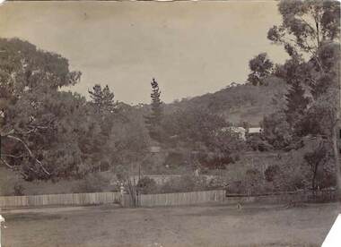 Bendigo Historical Society Inc.
Photograph - BUICK COLLECTION: PHOTOGRAPH OF 'THE GRANGE', BIG HILL
... Phot shows mostly vegetation and topography (Big Hill??) and little detail of home in distance with surrounding trees....Phot shows mostly vegetation and topography (Big Hill??) and little detail of home in distance with surrounding trees. ...Photograph of 'The Grange' , Big Hill . Inscription: 'Showing entrance gates in foreground'. Phot shows mostly vegetation and topography (Big Hill??) and little detail of home in distance with surrounding trees.person, family, buick family collection -
Victorian Aboriginal Corporation for Languages
Conference proceedings, Joe Blythe, Maintaining the links : language, identity and the land : proceedings of the Seventh FEL Conference, Broome, Western Australia, 22-24 September 2003, 2003
... Major headings: Languages & Land claims; Toponymy & Topography; Planning for the future; Language, identity & the environment; Language & Identity: Home & Away; Language revitalisation: Maintenance; Documenting ENdangered Languages...Victorian Aboriginal Corporation for Languages 33 Saxon Street Brunswick melbourne land claims East Kimberley ecotourism NSW Borroloola Gurr-goni Maningrida Maps, graphs, word lists Major headings: Languages & Land claims; Toponymy & Topography; Planning for the future; Language, identity & the environment; Language & Identity: Home & Away; Language revitalisation: Maintenance; Documenting ENdangered Languages Maintaining the links : language, identity and the land : proceedings of the Seventh FEL Conference, Broome, Western Australia, 22-24 September 2003 Conference proceedings Joe Blythe R McKenna Brown ...Major headings: Languages & Land claims; Toponymy & Topography; Planning for the future; Language, identity & the environment; Language & Identity: Home & Away; Language revitalisation: Maintenance; Documenting ENdangered LanguagesMaps, graphs, word listsland claims, east kimberley, ecotourism, nsw, borroloola, gurr-goni, maningrida -
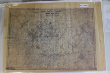 Coal Creek Community Park & Museum
Map of Mine and Details, Coal Creek Colliery Korumburra
... Most information seems to be printed, with topography drawn on....Most information seems to be printed, with topography drawn on. Coal Creek Colliery Korumburra Map of Mine and Details ...8516.1 - Schematic/map of coal creek mine workings, also detailing number surface features such as topographic heights, roads, railways, boreholes, etc. No Legend. Most information seems to be printed, with topography drawn on. -
Federation University Historical Collection
Book - Book - ledger, Ernest Pickering, Architectural Design by Ernest Pickering, 1941, 1941
... Contents include architectural influences, climate, topography, materials, social conditions, economic conditions, evolution of form, plan and volume, visible structure, materials, structure, creative principles, composition, design....Contents include architectural influences, climate, topography, materials, social conditions, economic conditions, evolution of form, plan and volume, visible structure, materials, structure, creative principles, composition, design. ...Ernest Pickering was author of Architecture at the University of Cincinnati.Brown hard covered book. Contents include architectural influences, climate, topography, materials, social conditions, economic conditions, evolution of form, plan and volume, visible structure, materials, structure, creative principles, composition, design.architecture, decorative elements, principles of design, ernest pickering, ballarat scbool of mines library -
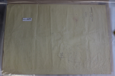 Coal Creek Community Park & Museum
Mine Map, 1933
... 6299.1 - Very faded map of Outtrim coal mine area detailing mine tunnels, tramways, topography and other information. Shows later small addendum/modification in ball point pen, Done 26/06/1953...Coal Creek Community Park & Museum 12 Silkstone Road Korumburra gippsland 6299.1 - Very faded map of Outtrim coal mine area detailing mine tunnels, tramways, topography and other information. Shows later small addendum/modification in ball point pen, Done 26/06/1953 Mine Map ...6299.1 - Very faded map of Outtrim coal mine area detailing mine tunnels, tramways, topography and other information. Shows later small addendum/modification in ball point pen, Done 26/06/1953 -
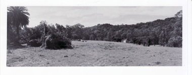 Whitehorse Historical Society Inc.
Photograph, Original Site of Schwerkolt Home, 14/02/2001 12:00:00 AM
... Photographed by Ted Goode to record the topography of site. Proposed Eastern Freeway Extension will cut through the treed area....Whitehorse Historical Society Inc. 2-10 Deep Creek Road Mitcham melbourne Photographed by Ted Goode to record the topography of site. Proposed Eastern Freeway Extension will cut through the treed area. schwerkolt family schwerkolt original cottage site. goode ted horse paddock Three copies of the view of original site of Schwerkolt home - now horse paddock adjoining Cottage Reserve. ...Photographed by Ted Goode to record the topography of site. Proposed Eastern Freeway Extension will cut through the treed area.Three copies of the view of original site of Schwerkolt home - now horse paddock adjoining Cottage Reserve.schwerkolt family, schwerkolt, original cottage site., goode, ted, horse paddock -
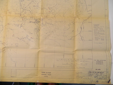 Kiewa Valley Historical Society
Plan - Kiewa Scheme General Plan 1958, S.E.C.V. Design & Construction Dept. Civil Branch, Dec. 1958
... Large topography map of the area covered by the Kiewa Hydro Electric Scheme in 1958. ...It is a good example of the work of a draftsman and the copying process in 1958. state electricity commission of victoria. kiewa hydro electric scheme plan engineer draftsman Large topography map of the area covered by the Kiewa Hydro Electric Scheme in 1958. ...The Kiewa Hydro Electric Scheme was constructed by the State Electricity Commission of Victoria. Draftsmen drew up the plan of the layout as per the instructions from the engineers. The plan was drawn up on a transparency sheet and paper prints run off on a 'dyeline' copier. The 'Chief draftsman' and 'Design engineer' and 'Civil engineers recommended it and approved it. Historic: This plan gives a time line for the work on the Kiewa Hydro Electric Scheme. It is a good example of the work of a draftsman and the copying process in 1958.Large topography map of the area covered by the Kiewa Hydro Electric Scheme in 1958. Mountain peaks are marked in red and named. Rivers, roads, construction infrastructure as well as the main areas / names of construction are named. Signed and dated by employees of the S.E.C.V. working on the scheme.state electricity commission of victoria., kiewa hydro electric scheme, plan, engineer, draftsman -
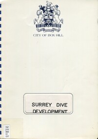 Surrey Hills Historical Society Collection
Book, Surrey Dive Development, Nov. 1986
... A report on the proposed development of the Surrey Dive and adjacent areas. It includes topography, site services, buildings, usage of the area including fishing, boating, model boats....Surrey Hills Historical Society Collection 190A Canterbury Road Canterbury melbourne A report on the proposed development of the Surrey Dive and adjacent areas. It includes topography, site services, buildings, usage of the area including fishing, boating, model boats. surrey dive box hill brick company surrey park shire of nunawading scott and furphy engineers pty ltd box hill An A4 spiral bound report. ...A report on the proposed development of the Surrey Dive and adjacent areas. It includes topography, site services, buildings, usage of the area including fishing, boating, model boats.An A4 spiral bound report.surrey dive, box hill brick company, surrey park, shire of nunawading, scott and furphy engineers pty ltd, box hill -
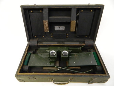 Kiewa Valley Historical Society
Stereoscope
... It was used by National Parks Victoria located at Mt Beauty to look at aerial photos so that they showed up the relief of the topography and therefore looked 3D....It was used by National Parks Victoria located at Mt Beauty to look at aerial photos so that they showed up the relief of the topography and therefore looked 3D. Used by National Parks Victoria staff located at the Mt Beauty office during the 1970's and early 1980's. national parks victoria. stereoscope. aerial photographs. scientific instrument. mt beauty. 3d Outside and top of box: written in black: No. 1026. ...The stereoscope was an interpretation device used to interpret aerial photography and the landscape. It was used by National Parks Victoria located at Mt Beauty to look at aerial photos so that they showed up the relief of the topography and therefore looked 3D.Used by National Parks Victoria staff located at the Mt Beauty office during the 1970's and early 1980's.Dark green wooden box with padded protection around the perimeter and on lid where 2 rectangular pieces of wood touch the stereoscope. The box is fitted with wooden dividers that fit around the stereoscope. The stereoscope is green metal with folding legs and sides attached to allow the stereoscope to sit on a surface. The instrument has 2 round glass ('mirrored viewing lens') cylinders eye distance apart, that allow light in from the side swinging doors. The amount of light is constricted by a rectangular piece of metal at the top of each leg. The box has swing clips used to close it and a metal swing handle all on the front side.The hinges are reinforced (and offer protection) by additional rubber pieces at each end. Inside the box is a brush made of bristle with a wooden handle - used for cleaning.Outside and top of box: written in black: No. 1026. On blue tape beneath: Mirror stereoscope 1026. written in black centre top of box: W10/WKA.0233. On front edge of box written in black: W10/WKA 0233. Inside box lid on silver plaque: Stereoscope Universal/ Made in / Australia / Die Casters Ltd. Victorianational parks victoria. stereoscope. aerial photographs. scientific instrument. mt beauty. 3d -
 Wodonga & District Historical Society Inc
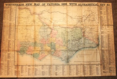
Map - Whiteheads New Map of Victoria, E. Whitehead & Co., engravers & lithographers, 1868
... It also shows roads, post office towns, railways, telegraphs, gold mining areas and notes on topography. Relief shown by hachures and spot heights. ...It also shows roads, post office towns, railways, telegraphs, gold mining areas and notes on topography. Relief shown by hachures and spot heights. ...Edward Whitehead was a printer and publisher active in Melbourne during the latter half of the 19th century. Whitehead founded his printing business at 67 Collins Street East in 1864 and, though not focused on maps, began publishing his own series of maps of Victoria in 1867. He focussed on producing highly detailed folding maps of Victoria which included a very detailed index of place names. His series of maps of Victoria became one of the most successful and most profitable series of regional maps of Australia ever produced.This is a very early map of Victoria showing Belvoir (Wodonga)A detailed early map of Victoria with counties clearly marked and shaded and a detailed index. It also shows roads, post office towns, railways, telegraphs, gold mining areas and notes on topography. Relief shown by hachures and spot heights. Includes a list of towns with distances from Melbourne on 3 sides of map. It is produced on paper mounted on linen.victoria cartography, rare maps victoria, whiteheads maps -
 Lakes Entrance Historical Society
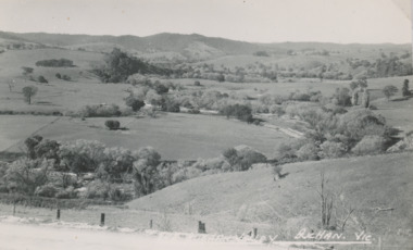
Postcard - Buchan Valley, Buchan Scene, c1930
... Topography...Lakes Entrance Historical Society 4 Marine Parade Lakes Entrance gippsland Topography Buchan Valley Buchan. Vic. Black and white Postcard of the Buchan Valley Buchan Scene Postcard Buchan Valley ...Black and white Postcard of the Buchan ValleyBuchan Valley Buchan. Vic.topography -
 Lakes Entrance Historical Society
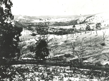
Photograph - Buchan Victoria 1925
... Topography...Lakes Entrance Historical Society 4 Marine Parade Lakes Entrance gippsland Topography Black and white photograph of a snow scene with ringbarked trees in foreground at Buchan Victoria Photograph Buchan Victoria 1925 ...Black and white photograph of a snow scene with ringbarked trees in foreground at Buchan Victoriatopography -
Lakes Entrance Historical Society
Book, Haldane Robert, Caving by Frank Moon, 2007
... Topography...Lakes Entrance Historical Society 4 Marine Parade Lakes Entrance gippsland Topography A short history of the Buchan Caves and Frank Moon's involvement in exploration, discovery and promotion of the various caves as a tourist destination. ...A short history of the Buchan Caves and Frank Moon's involvement in exploration, discovery and promotion of the various caves as a tourist destination. Written to celebrate the centenary of the discovery of the Fairy Caves.topography -
Lakes Entrance Historical Society
Book, Henderson Kent, The Buchan Experience, 1985
... Topography...Lakes Entrance Historical Society 4 Marine Parade Lakes Entrance gippsland Topography Discovery description of formation history since discovery by Frank Moon description of five caves, Royal, Fairy, Shades of Death, Murrindal and Lilly Pilly, tours of caves, flora and fauna at Buchan Victoria. ...Discovery description of formation history since discovery by Frank Moon description of five caves, Royal, Fairy, Shades of Death, Murrindal and Lilly Pilly, tours of caves, flora and fauna at Buchan Victoria.topography -
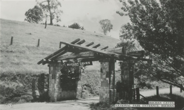 Lakes Entrance Historical Society
Postcard - Buchan Caves, Victoria, 1940 c
... Topography...Sent to Myrtle Fish nee Grant by her neice Jean Russ nee Grant possibly Jean's honeymoon 1950 c Topography Buchan Caves National Park Entrance Buchan Black and white postcard of entrance to Buchan Caves, bare hill on left and bush on right Buchan Victoria. ...Message on the back from Jean Grant to Myrtle Fish nee Grant. Sent to Myrtle Fish nee Grant by her neice Jean Russ nee Grant possibly Jean's honeymoon 1950 cBlack and white postcard of entrance to Buchan Caves, bare hill on left and bush on right Buchan Victoria. Plus another photo of the entry from an other angle. Plus another photo of the campers kitchen.Buchan Caves National Park Entrance Buchantopography