Showing 307 items matching "tourist maps"
-
 Warrnambool and District Historical Society Inc.
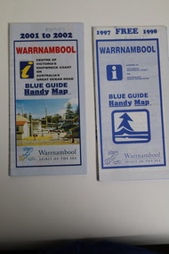
Pamphlet (Collection) - Warrnambool Tourist Maps, Warrnambool City Council, 1975 to 2002
... Warrnambool Tourist Maps...Warrnambool Tourist Maps...maps of Warrnambool and district for a particular year. Most have been produced by the City of Warrnambool or the local Chamber of Commerce but some have been produced by the Royal Automobile Club of Victoria. All have been produced for the benefit of local people and tourists...Sixteen pamphlets of varying sizes, designs, and colours featuring maps and photographic highlights of the district, reflecting the different designs and tourist requirements across the time frame 1975-2002....Warrnambool Tourist Maps Pamphlet Warrnambool Tourist Maps Warrnambool City Council Royal Automobile Club of Victoria ...Warrnambool Tourist Maps collected over the years by Warrnambool Historical Society membersPreservation of local maps for historical purposesEnclosed in A4 size plastic envelopes in an A4 size archival box and numbered and catalogued according to the date of acquisition.This collection has 16 pamphlets containing maps of Warrnambool and district and some accompanying printed materialwarrnambool tourism, city of warrnambool, shipwreck coast tourismwarrnambool tourism, city of warrnambool, shipwreck coast tourism -
 Warrnambool and District Historical Society Inc.
Map - Tourist Map Collection: Warrnambool & District Tourist Maps, Philprint, Warrnambool
... Tourist Map Collection: Warrnambool & District Tourist Maps......tourist maps...It appears to not have been commercially printed and includes details of attractions no longer operating in Warrnambool such as Warrnambool Aquarium and the Oasis Reptile Park and Zoo. [.2] Commercially printed Warrnambool tourist map (c mid 1980's) surrounded by advertisements for local businesses. [.3] Commercial printed December 1991 tourist map of Warrnambool and District includes a competition entry form [.4] Commercially printed tourist map aimed at children [.5] Walking map of Warrnambool and District [.6] Commercially printed Warrnambool tourist map (c mid 1980's) surrounded by advertisements for local businesses. ...[.1] Tourist Attractions In and Around Warrnambool two foolscap pages with two sides of type written information of local and district attractions. There is a Warrnambool City map...The map is surrounded by advertising for local businesses. Map Tourist Map Collection: Warrnambool & District Tourist Maps Philprint, Warrnambool Collett, Bain and Gaspar, Warrnambool Amazon Printing ...This is a diverse collection of Tourist Maps for the Warrnambool & District area. [.1] From information on this guide it dates from the mid 1970's. It appears to not have been commercially printed and includes details of attractions no longer operating in Warrnambool such as Warrnambool Aquarium and the Oasis Reptile Park and Zoo. [.2] Commercially printed Warrnambool tourist map (c mid 1980's) surrounded by advertisements for local businesses. [.3] Commercial printed December 1991 tourist map of Warrnambool and District includes a competition entry form [.4] Commercially printed tourist map aimed at children [.5] Walking map of Warrnambool and District [.6] Commercially printed Warrnambool tourist map (c mid 1980's) surrounded by advertisements for local businesses. This collection of maps from the mid 1970's to early 1990's gives an insight into what was available to assist tourists find their way around Warrnambool and District. They include advertisements for business operating during this period and include lists of available accommodation, eateries, and tourist attractions.[.1] Tourist Attractions In and Around Warrnambool two foolscap pages with two sides of type written information of local and district attractions. There is a Warrnambool City map with points of interest marked and a hand drawn district map; [.2]Commercially printed grid map of Warrnambool City surrounded by advertisements from local businesses. Reverse side has a district map and a map of the Warrnambool CBD surrounded by advertising. [.3] Brochure including small grid maps of Warrnambool and district listing accommodation providers and places of interest. Stylised blue & bright green design of Norfolk pines and sea. [.4] Children's treasure hunt map to Warrnambool There are two examples, one with blue edging (Jan 1986) and one with red edging (Aug 1993) Both have a circular logo with a stylised whale and lighthouse [.5] Walking maps of Warrnambool blue printed photo of four tourists walking coastline on the front cover. [.6] Commercially printed grid map of Warrnambool with a bright yellow inset of Warrnambool CBD main shopping centre. The map is surrounded by advertising for local businesses.warrnambool, tourist maps, warrnambool businesses, warrnambool accommodation -
 Clunes Museum
Pamphlet, WILKINS TOURIST MAPS
... Tourist Map...WILKINS TOURIST MAPS...Pamphlet PAMPHLET WILKINS TOURIST MAPS ...Colour Clunes area map outlining day tours around Clunes and surrounds with points of interest.tourist map, day tours of clunes -
 Kiewa Valley Historical Society
Maps - Tourist
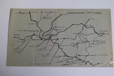
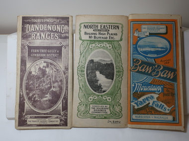
... Maps - Tourist...3 Tourist location maps (folded) and printed on parchment. 1. ...Also Red and Blue and mountains. Maps - Tourist ...These maps were all dated 1933 which was before the construction of the Kiewa Hydro Electric Scheme and when Tawonga was spelt Towonga. North East Victoria in 1933 was before the construction of the Kiewa Hydro Electric Scheme so the townships of Mt Beauty and Bogong are not shown. The description of the Snow Lines was important as skiers, bushwalkers and campers relied on them. The details on the map include "ADB. Numbered from A.1-377 round plates. CD Numbered from C 1-235 square plates. Poles about 3 chains apart 27 to the mile." 3 Tourist location maps (folded) and printed on parchment. 1. Tourist map of the Dandenong Ranges. Brown cover. dated 6-4-33. Govt. printer showing roads, tracks in red and heights of the land. 2. Tourist Map of Warburton, Mt Baw Baw, and Walhalla. Blue and Orange cover. dated 23-5-33 Govt. printer. 3 different maps of each area showin roads, tracks and timber tramways.Also in red and blue. 3. Tourist Map of North Eastern Victoria including Bogong High Plains Mt Buffalo Etc. Green cover. dated June 1933 Govt. printer. Main map and insert titled Bogong High Plains. Showing roads , tracks and tram ways. On insert showing snow poles. Also Red and Blue and mountains.By Authority of H.J. Green - 6 pence. Dept of Lands and Survey, Melbourne1933 maps, tourism maps, bogong high plains map 1933, snow poles -
 Marysville & District Historical Society
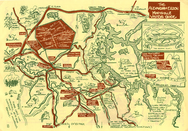
Map (Item) - Tourist map, The Alexandra and Eildon Standard, THE ALEXANDRA & EILDON MARYSVILLE VISITOR GUIDE, 1997
... Tourist map......tourist map...This tourist map was produced in 1997....A tourist map for the Alexandra, Eildon and Marysville region that was produced by the Alexandra and Eildon Standard newspaper....This tourist map was produced in 1997. A tourist map for the Alexandra, Eildon and Marysville region that was produced by the Alexandra and Eildon Standard newspaper. alexandra eildon marysville victoria australia tourist map alexandra & eildon standard c 1997/ PUBLISHED BY/ THE ALEXANDRA/ AND EILDON/ STANDARD./ GRAPHICS/ BY THE T.T.S./ EILDON. ...A tourist map for the Alexandra, Eildon and Marysville region that was produced by the Alexandra and Eildon Standard newspaper. This tourist map was produced in 1997.A tourist map for the Alexandra, Eildon and Marysville region that was produced by the Alexandra and Eildon Standard newspaper.c 1997/ PUBLISHED BY/ THE ALEXANDRA/ AND EILDON/ STANDARD./ GRAPHICS/ BY THE T.T.S./ EILDON.alexandra, eildon, marysville, victoria, australia, tourist map, alexandra & eildon standard -
 Marysville & District Historical Society
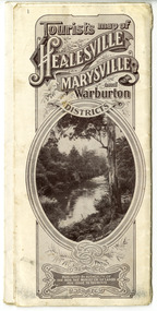
Map (Item) - Tourist Map, Tourists Resorts' Committee, Tourist's Map of Healesville Marysville and Warburton Districts, 13.10.1925
... Tourist Map......tourist map...A tourist map for Healesville, Marysville and Warburton that was produced by the Tourists Resorts' Committee. ...A tourist map for Healesville, Marysville and Warburton that was produced by the Tourists Resorts' Committee....Tourist's Map of Healesville Marysville and Warburton Districts Map Tourist Map Tourists Resorts' Committee W.J. ...A tourist map for Healesville, Marysville and Warburton that was produced by the Tourists Resorts' Committee. This map was produced in 1925.A tourist map for Healesville, Marysville and Warburton that was produced by the Tourists Resorts' Committee.Photo Lithographed at the Department of Lands and Survey, Melbourne by W.J. Butson./ 13.10.25healesville, marysville, warburton, victoria, tourists resorts' committee, ben cairn, mount donna buang, the black's spur, the acheron valley, narbethong, launching place, tourist information, tourism, map, tourist map -
 Marysville & District Historical Society
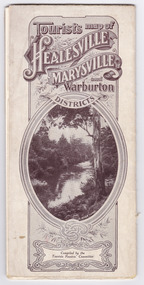
Map (Item) - Tourist Map, Tourists Resorts' Committee, Tourist's Map of Healesville Marysville and Warburton Districts, 13.10.1925
... Tourist Map......tourist map...A tourist map for Healesville, Marysville and Warburton that was produced by the Tourists Resorts' Committee. ...A tourist map for Healesville, Marysville and Warburton that was produced by the Tourists Resorts' Committee....Tourist's Map of Healesville Marysville and Warburton Districts Map Tourist Map Tourists Resorts' Committee W.J. ...A tourist map for Healesville, Marysville and Warburton that was produced by the Tourists Resorts' Committee. This map was produced in 1925.A tourist map for Healesville, Marysville and Warburton that was produced by the Tourists Resorts' Committee.Photo Lithographed at the Department of Lands and Survey, Melbourne by W.J. Butson./ 13.10.25healesville, marysville, warburton, victoria, tourists resorts' committee, ben cairn, mount donna buang, the black's spur, the acheron valley, narbethong, launching place, tourist information, tourism, map, tourist map -
 Peterborough History Group
Document - Maps, tourist information
... Maps, tourist information...Council boundaries, past tourist information, past maps...Peterborough History Group Peterborough great-ocean-road Council boundaries, past tourist information, past maps Historic town information and maps peterborough history Peterborough 3270 Photocopies, copies of maps, newspaper clipping Document Maps, tourist information ...Council boundaries, past tourist information, past mapsHistoric town information and mapsPhotocopies, copies of maps, newspaper clippingpeterborough history, peterborough 3270 -
 Marysville & District Historical Society
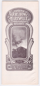
Map (Item) - Tourist Map, Department of Lands & Survey, Tourist's Map of Narbethong and Marysville Districts Victoria, 1913
... Tourist Map......tourist map...A tourist map for the Narbethong and Marysville Districts that was originally produced by the Department of Lands & Survey in 1925....A tourist map for the Narbethong and Marysville Districts that was originally produced by the Department of Lands & Survey in 1925....Tourist's Map of Narbethong and Marysville Districts Victoria Map Tourist Map Department of Lands & Survey John William Lindt W.J. ...A tourist map for the Narbethong and Marysville Districts that was originally produced by the Department of Lands & Survey in 1925.A tourist map for the Narbethong and Marysville Districts that was originally produced by the Department of Lands & Survey in 1925.Reprint of the 1925 Tourist brochure by permission R.E. Holmes Surveyor General By Authority: ALBERT J. MULLETT, Government Printer, Melbourne. Photo Lithographed at the Department of Lands and Survey Melbourne by W.J. Butson/ 26.8.13narbethong, marysville, victoria, department of lands & survey, the acheron valley, warburton, map, tourist map -
 Marysville & District Historical Society
Map (Item) - Tourist Map, Department of Lands & Survey, Tourist's Map of Narbethong and Marysville Districts Victoria, 1913
... Tourist Map......tourist map...A tourist map for the Narbethong and Marysville Districts that was originally produced by the Department of Lands & Survey in 1925....A tourist map for the Narbethong and Marysville Districts that was originally produced by the Department of Lands & Survey in 1925....Tourist's Map of Narbethong and Marysville Districts Victoria Map Tourist Map Department of Lands & Survey John William Lindt W.J. ...A tourist map for the Narbethong and Marysville Districts that was originally produced by the Department of Lands & Survey in 1925.A tourist map for the Narbethong and Marysville Districts that was originally produced by the Department of Lands & Survey in 1925.Reprint of the 1925 Tourist brochure by permission R.E. Holmes Surveyor General By Authority: ALBERT J. MULLETT, Government Printer, Melbourne. Photo Lithographed at the Department of Lands and Survey Melbourne by W.J. Butson/ 26.8.13narbethong, marysville, victoria, department of lands & survey, the acheron valley, warburton, map, tourist map -
Marysville & District Historical Society
Flyer (item) - Brochure, Artworkz Tourism, Marysville-Steavenson Falls, 2018
... A brochure including photographs and a tourist map of Marysville and some of the area's attractions focusing on Steavenson Falls. ...A brochure including photographs and a tourist map of Marysville and some of the area's attractions focusing on Steavenson Falls....A brochure including photographs and a tourist map of Marysville and some of the area's attractions focusing on Steavenson Falls. ...A brochure including photographs and a tourist map of Marysville and some of the area's attractions focusing on Steavenson Falls. A brochure including photographs and a tourist map of Marysville and some of the area's attractions focusing on Steavenson Falls. The Steavenson Falls is named after the Victorian Assistant Commissioner of Roads and Bridges, John Steavenson who arrived in Victoria in the early 1860s.Shadowed by over 30 Mountains and/ on the banks of the beautiful Goulburn River/ and Lake Eildon. This is our playground.marysville, steavenson falls, victoria, waterfalls, john steavenson -
 Marysville & District Historical Society
Map (Item) - Tourist map and guide, Warburton Ranges Tourism, Upper Yarra Valley and Marysville VICTORIA-AUSTRALIA, 1997
... Tourist map and guide.......tourist map...A tourist map and guide for the Upper Yarra Valley and Marysville produced by Warburton Ranges Tourism and Mystic Mountains Tourism in 1997....A tourist map and guide for the Upper Yarra Valley and Marysville produced by Warburton Ranges Tourism and Mystic Mountains Tourism in 1997....A tourist map and guide for the Upper Yarra Valley and Marysville produced by Warburton Ranges Tourism and Mystic Mountains Tourism in 1997. marysville victoria australia tourist map tourist guide mystic mountains tourism warburton ranges tourism lake mountain marysville post shop the marysville museum bruno's art and sculpture garden marylands country house blackwood cottages dalrymples guest cottages anastasia's cottage marysville hotel motel kerami guest house the cumberland A tourist map and guide for the Upper Yarra Valley and Marysville produced by Warburton Ranges Tourism and Mystic Mountains Tourism in 1997. ...A tourist map and guide for the Upper Yarra Valley and Marysville produced by Warburton Ranges Tourism and Mystic Mountains Tourism in 1997.A tourist map and guide for the Upper Yarra Valley and Marysville produced by Warburton Ranges Tourism and Mystic Mountains Tourism in 1997.marysville, victoria, australia, tourist map, tourist guide, mystic mountains tourism, warburton ranges tourism, lake mountain, marysville post shop, the marysville museum, bruno's art and sculpture garden, marylands country house, blackwood cottages, dalrymples guest cottages, anastasia's cottage, marysville hotel motel, kerami guest house, the cumberland -
 Marysville & District Historical Society
Map (Item) - Tourist Map, Department of Lands & Survey, Tourist Map of Healesville, Marysville and Warburton Districts, 1938
... Tourist Map...Tourist Map of Healesville, Marysville and Warburton Districts......tourist map...A tourist map for Healesville, Marysville and Warburton that was produced by the Victorian Department of Crown Lands and Survey, in conjunction with Victorian Railways, in 1938....A tourist map for Healesville, Marysville and Warburton that was produced by the Victorian Department of Crown Lands and Survey, in conjunction with Victorian Railways, in 1938....Tourist Map of Healesville, Marysville and Warburton Districts Map Tourist Map Department of Lands & Survey Victorian Railways ...A tourist map for Healesville, Marysville and Warburton that was produced by the Victorian Department of Crown Lands and Survey, in conjunction with Victorian Railways, in 1938.A tourist map for Healesville, Marysville and Warburton that was produced by the Victorian Department of Crown Lands and Survey, in conjunction with Victorian Railways, in 1938.Compiled by the Department of Lands and Survey, Melbourne Issued by the Betterment and Publicity Board, Victorian Railways, Melbourne, Victoria. May 1938healesville, marysville, warburton, victoria, tourist information, tourism, map, tourist map, victorian deparment of crown lands and survey, victorian railways, betterment and publicity board -
 Marysville & District Historical Society
Ephemera (Item) - Tourist map, Lansdowne Press, Marysville District No. 163, Unknown
... Tourist map...A tourist map of Marysville and the district which was produced by Broadbent's, a division of Lansdowne Press. ...A tourist map of Marysville and the district which was produced by Broadbent's, a division of Lansdowne Press....Marysville District No. 163 Ephemera Tourist map Lansdowne Press ...A tourist map of Marysville and the district which was produced by Broadbent's, a division of Lansdowne Press. Drawn map of Marysville and the district. Has a legend, scale, and a town map of Marysville. Has an index of locations and their grid details. Shows a list of other maps in the Robinson's and Broadbent's range.A tourist map of Marysville and the district which was produced by Broadbent's, a division of Lansdowne Press.marysville, victoria, maps, broadbent's, lansdowne press -
 Marysville & District Historical Society
Ephemera (Item) - Tourist map, The Paul Hamlyn Group, Marysville District No. 163, 1950s
... Tourist map...A tourist map of Marysville and the district which was produced by Broadbent's, a division of The Paul Hamlyn Group. ...A tourist map of Marysville and the district which was produced by Broadbent's, a division of The Paul Hamlyn Group....Marysville District No. 163 Ephemera Tourist map The Paul Hamlyn Group ...A tourist map of Marysville and the district which was produced by Broadbent's, a division of The Paul Hamlyn Group. Drawn map of Marysville and the district. Has a legend, scale and a town map of Marysville. Has an index of locations and their grid details. Gives details of addresses in New South Wales and Victoria for The Paul Hamlyn Group.A tourist map of Marysville and the district which was produced by Broadbent's, a division of The Paul Hamlyn Group.marysville, victoria, maps, broadbent's, the paul hamlyn group -
Stawell Historical Society Inc
Map, Tourist Map of Grampians/Halls Gap and Surrounds, 1928
... Tourist Map of Grampians/Halls Gap and Surrounds...Tourist Map of Grampians/Halls Gap and Surrounds...Stawell Historical Society Inc 46 Longfield St Stawell grampians Stawell Tourism Tourist Map of Grampians/Halls Gap and Surrounds Tourist Map of Grampians/Halls Gap and Surrounds Map ...Tourist Map of Grampians/Halls Gap and Surroundsstawell, tourism -
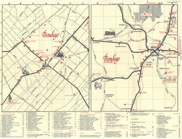 Bendigo Historical Society Inc.
Document - TED BEATIE COLLECTION: MAP, Pre 1980s
... Bendigo tourist map and information guide - printed by the Bendigo and District tourist Association...Ted Beattie Map Bendigo Bendigo tourist map and information guide - printed by the Bendigo and District tourist Association Document TED BEATIE COLLECTION: MAP ...Bendigo tourist map and information guide - printed by the Bendigo and District tourist Associationted beattie, map, bendigo -
Lakes Entrance Historical Society
Map - Discover East Gippsland, South Coast Tourism Ltd, c2020
... Tourist map of East Gippsland Showing Traralgon to Bega- Mt Beauty of Lakes Entrance...Tourist map of East Gippsland Showing Traralgon to Bega- Mt Beauty of Lakes Entrance Map Discover East Gippsland South Coast Tourism Ltd. ...Tourist map of East Gippsland Showing Traralgon to Bega- Mt Beauty of Lakes Entrance -
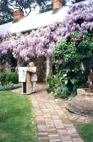 Whitehorse Historical Society Inc.
Photograph, Launch of Valley of the Arts Tourist Map, 1/10/2000 12:00:00 AM
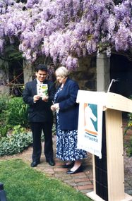
... Launch of Valley of the Arts Tourist Map...Coloured Photo of President of the Valley of the Arts Committee speaking at the launch of the Valley of the Arts Tourists Map at Schwerkolt Cottage....Whitehorse Historical Society Inc. 2-10 Deep Creek Road Mitcham melbourne valley of the arts schwerkolt Coloured Photo of President of the Valley of the Arts Committee speaking at the launch of the Valley of the Arts Tourists Map at Schwerkolt Cottage. Launch of Valley of the Arts Tourist Map Photograph Photograph ...Coloured Photo of President of the Valley of the Arts Committee speaking at the launch of the Valley of the Arts Tourists Map at Schwerkolt Cottage.valley of the arts, schwerkolt -
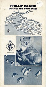 Phillip Island and District Historical Society Inc.
Map, Phillip Island District and Town Maps, 01/11/1967
... Map - PI District and Town Maps - Tourist brochure. Produced by the RSCV....Map-Phillip Island and District Maps - Tourist guide to Phillip Island tourist sites. ...Map - PI District and Town Maps - Tourist brochure. Produced by the RSCV. Historical Historical Society Map-Phillip Island and District Maps - Tourist guide to Phillip Island tourist sites. ...Map - PI District and Town Maps - Tourist brochure. Produced by the RSCV.HistoricalMap-Phillip Island and District Maps - Tourist guide to Phillip Island tourist sites. A3 page folded as a brochure. Blue print and photographs and advertisements.historical society -
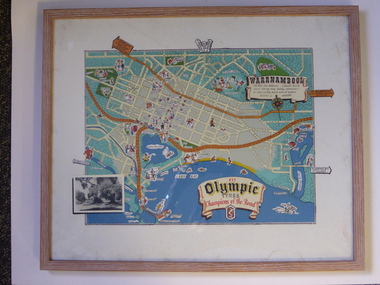 Warrnambool and District Historical Society Inc.
Advertising, Tourist Map of Warrnambool (framed x 2), 1950s
... Tourist Map of Warrnambool (framed x 2)...These framed tourist maps came from the Lane Foundation so it is presumed that they were from the office of Lane’s Travel Service which operated from 205 Raglan Parade Warrnambool with the known dates, the 1950s and 1960s. ...This is a tourist map of the Warrnambool C.B.D. and adjoining streets produced as an advertisement for Olympic Tyres. ...It has a wire at the back for attachment to a wall. Tourist Map of Warrnambool (framed x 2) Advertising ...These framed tourist maps came from the Lane Foundation so it is presumed that they were from the office of Lane’s Travel Service which operated from 205 Raglan Parade Warrnambool with the known dates, the 1950s and 1960s. The proprietor, Alan Lane, was a successful Warrnambool businessman who operated a Warrnambool and district bus service as well as his travel business. He was heavily involved in local community affairs being a Warrnambool Councillor for 18 years from 1952 to 1970 and President of the Warrnambool Chamber of Commerce for six years. He was a major donor to the Warrnambool Performing Arts Centre, the Warrnambool Art Gallery and the St. John of God Hospital and left the bulk of his estate to the Alan Lane Foundation which has contributed millions of dollars to local organizations and programs. Alan Lane died in 1995. These framed maps are of some interest as examples of the tourism maps used to promote the city and district in the 1950s and 60s. This is a tourist map of the Warrnambool C.B.D. and adjoining streets produced as an advertisement for Olympic Tyres. It is multi-coloured and has cartoon sketches of the main tourist attractions and pointers to attractions outside of the main city area. It includes an inset black and white photograph of the Warrnambool Botanic Gardens and an advertisement for Olympic Tyres. It is printed on a white background and is enclosed behind glass in a wooden frame of a light brown colour. It has a wire at the back for attachment to a wall. ‘Warrnambool – 163 miles from Melbourne – a popular tourist resort offering many holiday attractions – an ideal surfing beach with all modern facilities is avalable’ ‘Fit Olympic Tyres, Champions of the Road’ alan lane foundation, warrnambool tourism -
 Whitehorse Historical Society Inc.
Photograph, Launch of Valley of the Arts Tourist Map, 1/10/2000 12:00:00 AM
... Launch of Valley of the Arts Tourist Map...Coloured photo of Chief Executive Officer of City of Whitehorse, Noelene Duff, speaking at the launch of the Valley of the Arts Tourist Map at Schwerkolt Cottage on 6 October 2000....Launch of Valley of the Arts Tourist Map Photograph Photograph ...Coloured photo of Chief Executive Officer of City of Whitehorse, Noelene Duff, speaking at the launch of the Valley of the Arts Tourist Map at Schwerkolt Cottage on 6 October 2000.city of whitehorse, duff, noelene, valley of the arts, schwerkolt cottage -
 Whitehorse Historical Society Inc.
Photograph, Launch of Valley of the Arts Tourist Map, 1/10/2000 12:00:00 AM
... Launch of Valley of the Arts Tourist Map...Coloured photo of Bruce Atkinson, M.L.C., Ted and Valda Arrowsmith (President of Society) at the launch of the Valley of the Arts Tourists Map at Schwerkolt Cottage on 6 October 2000....Launch of Valley of the Arts Tourist Map Photograph Photograph ...Coloured photo of Bruce Atkinson, M.L.C., Ted and Valda Arrowsmith (President of Society) at the launch of the Valley of the Arts Tourists Map at Schwerkolt Cottage on 6 October 2000.victoria.legislative council. koonung province, atkinson, bruce, arrowsmith, ted, valda -
Lakes Entrance Historical Society
Map - Tourist Information Map Sale to Lake Tyers, Department of Sport and Recreation East Gippsland and Region, 2000
... Tourist Information Map Sale to Lake Tyers...Tourist information map from Sale to Lake Tyers...Lakes Entrance Historical Society 4 Marine Parade Lakes Entrance gippsland Tourism Information East Gippsland's Water Paradise Victoria's Riviera Tourist information map from Sale to Lake Tyers Map Tourist Information Map Sale to Lake Tyers Department of Sport and Recreation East Gippsland and Region South East Coast Tourism Ltd. ...Tourist information map from Sale to Lake TyersEast Gippsland's Water Paradise Victoria's Rivieratourism, information -
 Mission to Seafarers Victoria
Map - Street Map, Port de Papeete Tahiti
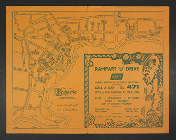
... Tourist map of the streets of Port de Papeete, Tahiti printed in greenish-grey ink on thin ochre coloured cardboard. ...Father Brady later donated the collection of; objects, documents and an extensive collection of cruise ship menus (1937-end of 20thC) to the Mission via the intermediary William Hastie, volunteer at the Mission for Seafarers. port de papeete tahiti hertz nick garlick nicholas garlick father brady william hastie ship engineer sailors seamen seafarers Tourist map of the streets of Port de Papeete, Tahiti printed in greenish-grey ink on thin ochre coloured cardboard. ...Several items were given by a seafarer, Mr Nicholas Garlick (1926-2009) into the care of Father Brady who retired from St Pauls Cathedral, Melbourne in 2018. Father Brady later donated the collection of; objects, documents and an extensive collection of cruise ship menus (1937-end of 20thC) to the Mission via the intermediary William Hastie, volunteer at the Mission for Seafarers.Tourist map of the streets of Port de Papeete, Tahiti printed in greenish-grey ink on thin ochre coloured cardboard. Produced for Hertz rent a car (see media). port de papeete, tahiti, hertz, nick garlick, nicholas garlick, father brady, william hastie, ship engineer, sailors, seamen, seafarers -
 Lara RSL Sub Branch
Photograph The Kokoda Trail - "Courage, Mateship, Sacrifice, Endurance", Kokoda Trail - "Courage, Mateship, Sacrifice, Endurance"
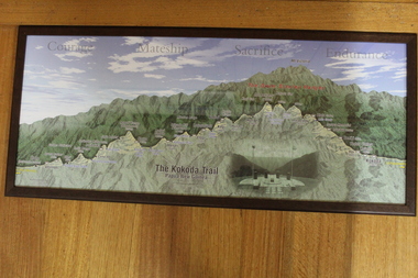
... Tourist map of the Kokoda Trail, Owen Stanly Ranges - IIolo to Kokoda, Papua to New Guinea...Lara RSL Sub Branch McClelland Ave Lara Tourist map of the Kokoda Trail, Owen Stanly Ranges - IIolo to Kokoda, Papua to New Guinea Graphical map of the Kokoda Trail kokoda trail owen stanley ranges None Picture Kokoda Trail - Papua New Guinea - Owen Stanley Ranges showing a cut through to emphasize the variation in height in the Ranges, with left to right of the villages and townships that represent the trail. ...Tourist map of the Kokoda Trail, Owen Stanly Ranges - IIolo to Kokoda, Papua to New GuineaGraphical map of the Kokoda TrailPicture Kokoda Trail - Papua New Guinea - Owen Stanley Ranges showing a cut through to emphasize the variation in height in the Ranges, with left to right of the villages and townships that represent the trail. Also contains an inset picture of the Memorial at Isurava Village.Nonekokoda trail, owen stanley ranges -
 Whitehorse Historical Society Inc.
Photograph, Launch of Valley of the Arts Tourist Map, 1/10/2000 12:00:00 AM
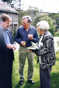
... Launch of Valley of the Arts Tourist Map...Coloured photo of Minister for Tourism, John Pandazopoulos and Mayor of City of Whitehorse, Cr, Jessie MacCallum at launch of Co-operative venture Valley of the Arts Tourist Map at Schwerkolt Cottage on 6th October 2000....Launch of Valley of the Arts Tourist Map Photograph Photograph ...Coloured photo of Minister for Tourism, John Pandazopoulos and Mayor of City of Whitehorse, Cr, Jessie MacCallum at launch of Co-operative venture Valley of the Arts Tourist Map at Schwerkolt Cottage on 6th October 2000.pandazopoulos, john, maccallum. jessie, city of whitehorse, valley of the arts, schwerkolt cottage. -
 Cheese World Museum
Book, Queen City Printers Pty Ltd, Collins Street Directoryand Publice Guide: 8th Edition
... maps...tourist information...COLLINS' STREET DIRECTORY/AND/PUBLIC GUIDE/8th Edition/2/6 each/CONTENTS/ Suburban Maps/Street Indices/Public Buildings/Tourist Information and Holiday Notes/Weights and Measures/Postal Rates/Calendar/Conversion Tables/Justices of the Peace/And other useful and up-to-date matter...-not listed Allansford Uebergang street directory public guide Collins Melbourne maps tourist information Queen City Printers Pty Ltd almanacs local history COLLINS' STREET DIRECTORY/AND/PUBLIC GUIDE/8th Edition/2/6 each/CONTENTS/ Suburban Maps/Street Indices/Public Buildings/Tourist Information and Holiday Notes/Weights and Measures/Postal Rates/Calendar/Conversion Tables/Justices of the Peace/And other useful and up-to-date matter White hard cover pocket-sized street directory book with red cloth spine. ...The Percy Uebergang family lived at Tooram Park, Allansford from 1912 until 1992. This booklet was part of the collection of items given into the care of the Cheese World Museum. Uebergang catalogue No. -not listed White hard cover pocket-sized street directory book with red cloth spine. The front cover has a blue and yellow background with title, contents, edition listed and a policeman in a blue uniform. The back cover has information in black print. Melbourne and suburbs maps throughout. 439 pages.COLLINS' STREET DIRECTORY/AND/PUBLIC GUIDE/8th Edition/2/6 each/CONTENTS/ Suburban Maps/Street Indices/Public Buildings/Tourist Information and Holiday Notes/Weights and Measures/Postal Rates/Calendar/Conversion Tables/Justices of the Peace/And other useful and up-to-date matterallansford, uebergang, street directory, public guide, collins, melbourne, maps, tourist information, queen city printers pty ltd, almanacs, local history -
 Melbourne Tram Museum
Map, The Met, "The Met PASS Map to Melbourne", c1988/90
... Maps... Tourist Tickets...Melbourne Tram Museum 8 Wallen Road Hawthorn melbourne Trams tramways The Met Melbourne Maps Tourist Tickets Folded Map of Melbourne Rail and Tram lines, titled "The Met PASS Map to Melbourne" Tram Map - probably soon after conversion of the St Kilda and Port Melbourne lines to Light Rail, though these are not shown. ...Folded Map of Melbourne Rail and Tram lines, titled "The Met PASS Map to Melbourne" Tram Map - probably soon after conversion of the St Kilda and Port Melbourne lines to Light Rail, though these are not shown. Opened November 1987. Rail Map - shows Route 96 north section as Light Rail, co-ordinated bus routes, and the Altona line as going to Werribee. This route was opened in 1985. Date of Map c1988/1990. Has details of Museums, Art Galleries, Shopping, Gardens and Sports Arenas. See also Reg Item 379 for a similar item.trams, tramways, the met, melbourne, maps, tourist tickets -
 Marysville & District Historical Society
Map (Item) - Tourist and business map, Narbethong Community and Tourism Group, Narbethong Buxton Taggerty Tourist and Business Map, 04-2008
... Tourist and business map...Narbethong Buxton Taggerty Tourist and Business Map......tourist and business map...A tourist and business map of Narbethong, Buxton and Taggerty. ...A tourist and business map of Narbethong, Buxton and Taggerty. ... and Business Map Map Tourist and business map Narbethong Community and Tourism Group ...A tourist and business map of Narbethong, Buxton and Taggerty. This map was produced by the Narbethong Community and Tourism Group in April 2008. It was produced to promote the natural attractions, adventure activities and food trail from the Black Spur, through Narbethong, Buxton and Taggerty.A tourist and business map of Narbethong, Buxton and Taggerty.This publication has been produced by the Narbethong Community and Tourism/ Group (NCTG) to promote the natural attractions, adventure activities and food/ trail from the Black Spur, through Narbethong, Buxton and Taggerty./ the information provided in this publication has been supplied by the individual/ members. NCTG takes no responsibility for its accuracy./ April 2008narbethong, buxton, taggerty, victoria, australia, tourist and business map, narbethong community and tourism group, acheron valley, yarra track, wood's point, black spur, mystic mountains, the meeting of the waters, cathedral range, danico design counted cross stitch, things of sand & stone, buxton zoo nursery & oddz & enz, willowbank at taggerty, safe trek 4wd services, pnl 4wdriving, buxton trout and salmon farm, mystic mountains ski hire & outdoors, narbethong ski hire, highwood health centre, cathedral view natural therapies, narby cabinets, plants by shelian, gb timber, executive signs, rb automotive repairs, buxton car care, marysville towing & equipment hire, martyn slade building design, cathedral peak framing, black spur roadhouse & ski hire, tudor lodge roadhouse & ski hire, buxton roadhouse & persian bazzar, buxton post office general store & niche bar, igloo roadhouse, taggerty store, narby eggs, marapana agistment park, mantirri blueberry farm, carmyle farm, hazelwood hazelnuts, south cathedral lavender farm, cathedral cherries, black spur motel & caravan park, woodlands rainforest retreat, chestnut glade, black spur inn, wombat cottage, abbey lake luxury b & b spa cottages, blue views holiday cottages, camp narbethong, marapana farm stay b & b, mantirri blueberry farm b & b, little dene garden cottages, silverstream b & b cottages, nareen cabins, moondai farm b & b, south cathedral farm luxury b & b cottages, yarrolyn caravan park, sarsens rest, lomah retreat, pinjarra gardens, kingbilli country estate, henry viii manor house, buxton hotel, butters cafe of buxton, wagtail wines, little river wines, lanterns at willowbank, wirrawilla rainforest walk, wilhemina falls, the cascades