Showing 36 items matching "tower hill estate"
-
 Surrey Hills Historical Society Collection
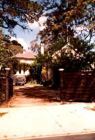
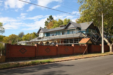
Photograph, Rear of Varndean from Willcyrus Street, 1988, 1988
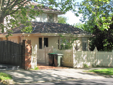
... tower hill lodge...corcovado...varndean...tower hill estate...In 1888 the Tower Hill estate and the home (Tower Hill Lodge) were auctioned, but the house was not sold. ...In 1888 the Tower Hill estate and the home (Tower Hill Lodge) were auctioned, but the house was not sold. ...Ref: Alan Holt records - This property has had a number of different names throughout its history. William Cook, a farmer, bought the land it stands on in 1876. In 1882 he was rated for a house (not the current one) on 11 acres. The present house was built in 1885 by John Clark, an auctioneer. In 1888 the Tower Hill estate and the home (Tower Hill Lodge) were auctioned, but the house was not sold. In 1889 the house was purchased by Captain Shepherd. Records show that in 1894 the owners were Mr Thomas and Mrs Hortenzia Howell. They named the house 'Corcovado'. Later they added a study with a corner designed to provide views from the Dandenong Ranges around to Mt Macedon. In 1944 Mr and Mrs Lionel Adams renamed the house 'Varndean'.This is one of the earliest surviving houses in Surrey Hills.A colour photo taken from the street at the rear of a Victorian-style house with ornate chimneys and a slate roof. A parked car is seen in front of the house. The house sits behind a timber fence and is partly hidden by mature shrubs and trees.victorian style, tower hill lodge, corcovado, varndean, tower hill estate, mr william cook, mr john clark, mrs hortenzia howell, mr lionel adams, mrs lionel adams, surrey hills, captain louis shepherd, mr thomas howell -
 Warrnambool and District Historical Society Inc.
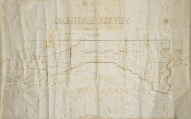
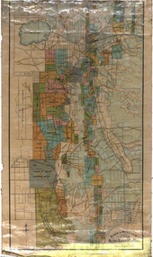
Map - Farnham Survey, 1850s
... tower hill...dennington...farnham estate...Tower Hill to the Merri River at Dennington. The map appears to date from the 1850s This early map is of considerable significance as it shows details of the Farnham Special Survey. William Rutledge and his survey are important influences in the development of Warrnambool and district with the establishment of settlements at Killarney, Yangery and Tower Hill. Farnham Special Survey william rutledge tower hill dennington farnham estate ...This is a map of the Farnham Special Survey. In 1843 William Rutledge purchased this Special Survey of 5,120 acres and named it Farnham. This Survey extended from Tower Hill to the Merri River at Dennington. The map appears to date from the 1850s This early map is of considerable significance as it shows details of the Farnham Special Survey. William Rutledge and his survey are important influences in the development of Warrnambool and district with the establishment of settlements at Killarney, Yangery and Tower Hill.A hand drawn map on waxed paper in brown, black and blue ink. It shows Armstrong's Bay, sea, Crown Land , the names of properties and some roads. It includes a compass direction diagram.farnham special survey, william rutledge, tower hill, dennington, farnham estate -
 Warrnambool and District Historical Society Inc.
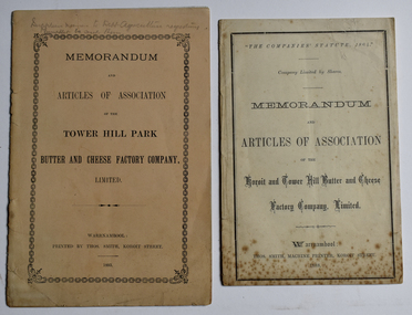
Booklet - Memorandum and Articles of Association 003048.1 Tower Hill Park Butter and Cheese Factory Company Ltd; 003048.2 Koroit and Tower Hill Butter and Cheese Factory Company Ltd, Thomas Smith Printer, 003048.1 1893; 003048.2 1888
... Tower Hill area. These factories later became part of the Koroit Factory These two memorandums of association document the formation of two early butter and cheese factories in the Koroit and Tower Hill area, listing the first directors. A meeting at the Koroit Town Hall on May 23, 1888, unanimously decided to form the Koroit and Tower Hill Butter Factory coy. Ltd. Mr W J Anderson started the movement to establish a butter factory to suit the convenience of the share farmers of the Tower Hill Park estate ...These booklets document the formation and the aims of two early dairy factories in the Koroit and Tower Hill area. These factories later became part of the Koroit FactoryThese two memorandums of association document the formation of two early butter and cheese factories in the Koroit and Tower Hill area, listing the first directors. A meeting at the Koroit Town Hall on May 23, 1888, unanimously decided to form the Koroit and Tower Hill Butter Factory coy. Ltd. Mr W J Anderson started the movement to establish a butter factory to suit the convenience of the share farmers of the Tower Hill Park estate in the early 1890's. Both of these factories were ultimately bought out by the Koroit Factory.003048.1 10 page small buff coloured booklet dated 1893 with pencilled note "Supplier names to Dept. Agriculture requesting Pamphlets be sent them" 003048.2 8 page cream coloured booklet dated 1888003048.1 Memorandum and Articles of Association of the Tower Hill Park Butter and Cheese Factory company, Limited. Warrnambool Printed by Thos. Smith, Koroit Street. 1893 003048.2 "The Companies' Statute, 1864" company limited by Shares Memorandum and Articles of Association of the Koroit and Tower Hill Butter and Cheese Factory, Limited. ~ Warrnambool: Thos. Smith, Machine Printer, Koroit Street, 1888memorandum and articles of association, butter and cheese factory, tower hill park butter and cheese factory, koroit and tower hill butter and cheese factory, thomas smith printer, dairying factory, john wilson anderson, john campbell jnr., joseph lamb wall, thomas gleeson, john quirk, michael hally, robert kerr, william crowe, james young, patrick mcgrath, richard skilbeck, peter mcvicar, tower hill park, illowa -
 Warrnambool and District Historical Society Inc.
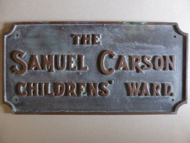
Plaque - Brass Plate, The Samuel Carson Childrens' Ward, C 1925
... Samuel Carson was a local farmer who in the late 1800's acquired land to the West of Warrnambool in the Farnham park estate and towards Tower Hill near Gorman's lane. By the time of his death on May 23, 1920 he left an amount of 11666 pounds. ...Warrnambool and District Historical Society Inc. 2 Gilles Street (south of Merri St) Warrnambool great-ocean-road Samuel Carson was a local farmer who in the late 1800's acquired land to the West of Warrnambool in the Farnham park estate and towards Tower Hill near Gorman's lane. By the time of his death on May 23, 1920 he left an amount of 11666 pounds. ...Samuel Carson was a local farmer who in the late 1800's acquired land to the West of Warrnambool in the Farnham park estate and towards Tower Hill near Gorman's lane. By the time of his death on May 23, 1920 he left an amount of 11666 pounds. Apart from amounts left to individuals, he bequeathed one hundred pounds each to ten different orphanages, and homes for neglected children and the blind and leaving the remainder to charitable organisations at the discretion of his trustees.The donation of 3500 pounds in August 1922 was in the latter category. This plaque commemorates Samuel Carson's generosity to the newly refurbished Warrnambool Base Hospital. He left a son William who farmed at Yangery at the time of his father's death. This item is significant in that it links a local identity through his generous donation to the local hospital. It therefore has strong social,historical and interpretative value. His generosity is a significant part of the history of Warrnambool Base Hospital.Heavy rectangular cast brass plate with raised edge and text in capitals. Corners have rounded cutouts and there is a hole in each corner for attachment. The Samuel Carson Childrens' Ward.warrnambool, warrnambool base hospital, samuel carson, samuel carson warrnambool, childrens' ward warrnambool 1928 -
 Warrnambool and District Historical Society Inc.
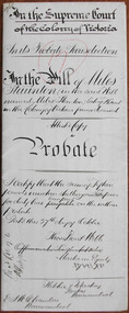
Document - Miles Staunton Probate 1895, 1898
... He died at Tower Hill in 1898 at the age of 72. He was a farmer in the Koroit district and left real estate to the value of £2799 and personal estate to the value of £128. ...He died at Tower Hill in 1898 at the age of 72. He was a farmer in the Koroit district and left real estate to the value of £2799 and personal estate to the value of £128. ...Tait collection: item 46 of 62 This is a document giving details of the Will and Probate of Miles Staunton (called Miles Stanton in the Will and Myles Staunton in the official Victorian death records). He died at Tower Hill in 1898 at the age of 72. He was a farmer in the Koroit district and left real estate to the value of £2799 and personal estate to the value of £128. The chief beneficiaries were his wife and children. Miles Stanton was unable to write and signed his will with a cross. The lawyers involved, Fletcher and Mackay and Ernest Chambers, had legal offices in Warrnambool at the end of the 19th century. The document, with others, was passed down to successive lawyers occupying the legal premises in Kepler street (Fletcher and Mackay, later Mackay Taylor) and located in this building in 2014. This document is of some interest as it gives details of the Will and Probate of Miles Staunton who was a 19th century farmer in the Koroit district.This is a white piece of paper folded in two to make four pages. Three of the pages have ruled margins in red and there is handwritten material on four pages in black ink. There is no proper seal attached but there is a hand-drawn circular sketch representing the seal of the Supreme Court of Victoria. The document contains information on the Will and Probate of Miles Staunton of Koroit who died in 1898.In the Supreme Court of the Colony of Victoria In the Probate Jurisdiction In the Will of Miles Staunton in the Will named Miles Stanton late of Koroit in the Colony of Victoria farmer deceasedmiles staunton, ernest chambers, fletcher and mackay, warrnambool, tait collection -
 Warrnambool and District Historical Society Inc.
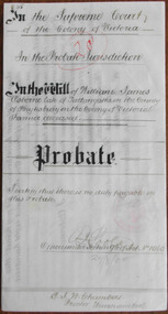
Document - William J Osborne Probate 1900Document, 1900
... Tower Hill. A William Osborne is listed as a Wangoom farmer in 1856, a farmer at ‘Thompson’s Old Farm’ in Allansford in 1866 and a farmer at Winton Farm on the Allansford Road near Shipley in 1869 but these references may be to William Osborne’s father as there is mention of a William Osborne, Junior at that time. William James Osborne left real estate...Tower Hill. A William Osborne is listed as a Wangoom farmer in 1856, a farmer at ‘Thompson’s Old Farm’ in Allansford in 1866 and a farmer at Winton Farm on the Allansford Road near Shipley in 1869 but these references may be to William Osborne’s father as there is mention of a William Osborne, Junior at that time. William James Osborne left real estate ...Tait collection: item 48 of 62 This is a document giving details of the Will and Probate of William James Osborne, a Tallangatta farmer who died in 1896 at the age of 59. His death place is given as Tower Hill. A William Osborne is listed as a Wangoom farmer in 1856, a farmer at ‘Thompson’s Old Farm’ in Allansford in 1866 and a farmer at Winton Farm on the Allansford Road near Shipley in 1869 but these references may be to William Osborne’s father as there is mention of a William Osborne, Junior at that time. William James Osborne left real estate to the value of £560 and personal estate to the value of £81 to his wife, Hannah. The lawyer who drew up this document was Ernest Chambers who had legal offices in Warrnambool, Koroit and Port Fairy at the end of the 19th century and the beginning of the 20th century. He was in possession of this document and it has passed down to successive lawyers occupying the legal premises in Kepler Street where it was located in 2014 (former premises of the law firm of Mackay Taylor). This document is of interest as it gives details of the Will and Probate of William James Osborne, a farmer in the Allansford area in the 19th century. This is a cream-coloured piece of parchment paper folded in two to make four pages. Three of the pages have handwritten material in brown ink and the pages are not ruled. A seal of the Supreme Court of Victoria is attached with a green ribbon and there is one red stamp of the Master in Equity of the Supreme Court. The document is somewhat stained but legible. The document gives details of the Will and Probate of William Osborne of Tallangatta in the County of Heytesbury. He died in 1896. In the Supreme Court of the Colony of Victoria in the Probate Jurisdiction in the Will of William James Osborne late of Tallangatta in the County of Heytesbury in the Colony of Victoria Farmer deceased. ernest chambers, warrnambool lawyer, william james osborne, tallangatta, tait collection -
 Bendigo Historical Society Inc.
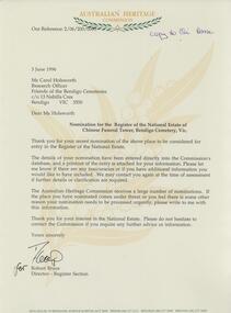
Document - FRIENDS OF WHITE HILLS CEMETERY COLLECTION: LETTER, 3 June 1996
... Letter to Carol Holsworth from Robert Bruce, Australian Heritage Commission RE nomination of Chinese Funeral Tower at Bendigo Cemetery for the register of the National Estate. Letter dated 3 June 1996. Document FRIENDS OF WHITE HILLS CEMETERY COLLECTION: LETTER ...Document. Letter to Carol Holsworth from Robert Bruce, Australian Heritage Commission RE nomination of Chinese Funeral Tower at Bendigo Cemetery for the register of the National Estate. Letter dated 3 June 1996. -
 Bendigo Historical Society Inc.
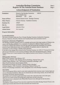
Document - FRIENDS OF WHITE HILLS CEMETERY COLLECTION: REPORT, 3 June 1996
... Tower, Bendigo Cemetery to the register of the National Estate Database. Two pages, Nominated by the Friends of the Bendigo Cemeteries. Dated 3 June 1996. Document FRIENDS OF WHITE HILLS ...Document. Acknowledgement of Nomination of the Chinese Funeral Tower, Bendigo Cemetery to the register of the National Estate Database. Two pages, Nominated by the Friends of the Bendigo Cemeteries. Dated 3 June 1996.document, memo, report -
 Federation University Historical Collection
Map, Ballarat and Sebastapol Gold Mines, Late 19th Century
... tower hill co...south plateau...south star co...band of hop and albion consols...prince regent co...chenhall and co...despza...buninyong estate...Barker Library (top floor) Mount Helen goldfields gold mines mine allotment map mining leases ballarat sebastopol rider and mercer golden shaft co prince of wales and bonshaw united leviathan gold mines holst and co speedwell co sebastopol plateau rothschild co tower hill co south plateau south star co band of hop and albion consols prince regent co chenhall and co despza buninyong estate one eye hully winter's freehold luplau plateau e. morey carrill's quartz printed "Rider & Mercer's Plan of the Ballarat & Sebastapol Gold Mines Scale 30 Chains to One Inch" colored printed map on paper lined onto linen backing Ballarat and Sebastapol Gold Mines Map Map Rider & Mercer ...colored printed map on paper lined onto linen backingprinted "Rider & Mercer's Plan of the Ballarat & Sebastapol Gold Mines Scale 30 Chains to One Inch"gold mines, mine allotment map, mining leases, ballarat, sebastopol, rider and mercer, golden shaft co, prince of wales and bonshaw united, leviathan gold mines, holst and co, speedwell co, sebastopol plateau, rothschild co, tower hill co, south plateau, south star co, band of hop and albion consols, prince regent co, chenhall and co, despza, buninyong estate, one eye hully, winter's freehold, luplau plateau, e. morey, carrill's quartz -
 Ballarat Tramway Museum
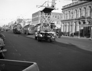
Negative - SECV Geelong 21, 23 & Tower Truck Ryrie St, Hugh Ballment, 25/5/1954
... Photo shows Geelong trams 21 and 23 and another behind the truck, in Ryrie St at the intersection with Moorabool St and the SEC Tower Truck with a worker standing on the platform at work, possibly making adjustments to the crossover wire or frog pan, just west of the intersection with Moorabool St. A uniformed employee, possibly an Inspector can be seen at the right hand side of the photo. In the background is Cox, the Bank of NSW, the ANZ bank and L N HIll Real estate...Ballarat Tramway Museum South Gardens Reserve Wendouree Parade Ballarat Ballarat goldfields Photo shows Geelong trams 21 and 23 and another behind the truck, in Ryrie St at the intersection with Moorabool St and the SEC Tower Truck with a worker standing on the platform at work, possibly making adjustments to the crossover wire or frog pan, just west of the intersection with Moorabool St. A uniformed employee, possibly an Inspector can be seen at the right hand side of the photo. In the background is Cox, the Bank of NSW, the ANZ bank and L N HIll Real estate ...Photo shows Geelong trams 21 and 23 and another behind the truck, in Ryrie St at the intersection with Moorabool St and the SEC Tower Truck with a worker standing on the platform at work, possibly making adjustments to the crossover wire or frog pan, just west of the intersection with Moorabool St. A uniformed employee, possibly an Inspector can be seen at the right hand side of the photo. In the background is Cox, the Bank of NSW, the ANZ bank and L N HIll Real estate agent. Based on the date of a series of colour slides and a sleeve date of 1954 photo taken 25/5/1954. Yields information about the SEC Geelong tower truck and trams 21 and 23 at Ryrie St.Negative - 127 film black and whitetramways, tramcars, geelong, tram 21, tram 23, ryrie st, tram tower truck, tower wagon -
 Robin Boyd Foundation
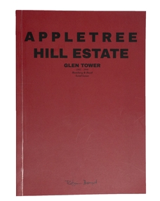
Booklet, Appletree Hill Estate (facsimile), 1965-66
... Hill Housing Development, Glen Tower Drive, Glen Waverley, 1966. In 1965 Lend Lease Homes commissioned Robin Boyd to design six brick veneer houses. They were built as a display village at Appletree Hill. appletree estate architecture domestic architecture housing estate Walsh St library A facsimile of an booklet to advertise Lend Lease homes designed by Robin Boyd. ...This is a facsimile copy, produced by Masters of Architecture Students at the Melbourne School of Design University of Melbourne, 2017. This feature correspondence, newspaper articles, and other material concerning the development of Appletree Hill Housing Development, Glen Tower Drive, Glen Waverley, 1966. In 1965 Lend Lease Homes commissioned Robin Boyd to design six brick veneer houses. They were built as a display village at Appletree Hill.A facsimile of an booklet to advertise Lend Lease homes designed by Robin Boyd.appletree estate, architecture, domestic architecture, housing estate, walsh st library -
 Surrey Hills Historical Society Collection
Folder of real estate advertisements, Folders of real estate advertisements (Streets beginning with T), Various
... Surrey Hills Historical Society Collection 190A Canterbury Road Canterbury melbourne tevelton lane thames street the avenue theodore street thistle street thornton avenue tower street trafalgar street tyndall street A4 folders with individual pockets for each property in streets beginning with T located in Surrey Hills and Mont Albert. Folders are ordered by street name and then chronologically by property number. Each property has its own pocket. This may include multiple real estate ...A4 folders with individual pockets for each property in streets beginning with T located in Surrey Hills and Mont Albert. Folders are ordered by street name and then chronologically by property number. Each property has its own pocket. This may include multiple real estate advertisements collected from sales over time. It may also include copies of any research undertaken by Alan Holt and / or members of the SHNCHC team. These are augmented by cards in the Alan Holt index file and by his property registers of Surrey Hills and Mont Albert.tevelton lane, thames street, the avenue, theodore street, thistle street, thornton avenue, tower street, trafalgar street, tyndall street -
Koorie Heritage Trust
Book, Bennett, Richard, Richard Bennetts early days of Port Fairy, 1984
... .; Three Articles by 'Bruni' - The Yangery Estate; Tower-hill Park; Koorongah. viii, 92 p. : ill. ; plates; maps; 25 cm. ...Contents: Richard Bennett's Early Days of Port Fairy - ...; Three Articles by 'Bruni' - The Yangery Estate; Tower-hill Park; Koorongah.viii, 92 p. : ill. ; plates; maps; 25 cm.Contents: Richard Bennett's Early Days of Port Fairy - ...; Three Articles by 'Bruni' - The Yangery Estate; Tower-hill Park; Koorongah.port fairy-history, aborigines of port fairy district. im cain; -
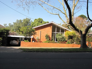
 Surrey Hills Historical Society Collection
Photograph - 1 Tower Street, Surrey Hills, The Street Where You Live Project
... Hills Neighbourhood Centre and covered the postcode 3127 in the cities of Boroondara and Whitehorse. These photos provide a snapshot of real estate in the suburbs of Mont Albert and Surrey Hills during a period of rapid change with many properties on large blocks demolished to create higher density residential development or renewal of single dwellings. At particular risk were properties not covered by heritage overlays, in particular interwar housing and post 1950's housing. The Street Where You Live Project Photograph 1 Tower ...Photos documenting this address as part of a photographic series undertaken by volunteer photographers during 2013 and 2014 for The Street Where You Live Project. This was organised through the Surrey Hills Neighbourhood Centre and covered the postcode 3127 in the cities of Boroondara and Whitehorse.These photos provide a snapshot of real estate in the suburbs of Mont Albert and Surrey Hills during a period of rapid change with many properties on large blocks demolished to create higher density residential development or renewal of single dwellings. At particular risk were properties not covered by heritage overlays, in particular interwar housing and post 1950's housing. -
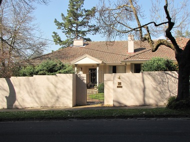
 Surrey Hills Historical Society Collection
Photograph - 2 Tower Street, Surrey Hills, The Street Where You Live Project
... Hills Neighbourhood Centre and covered the postcode 3127 in the cities of Boroondara and Whitehorse. These photos provide a snapshot of real estate in the suburbs of Mont Albert and Surrey Hills during a period of rapid change with many properties on large blocks demolished to create higher density residential development or renewal of single dwellings. At particular risk were properties not covered by heritage overlays, in particular interwar housing and post 1950's housing. The Street Where You Live Project Photograph 2 Tower ...Photos documenting this address as part of a photographic series undertaken by volunteer photographers during 2013 and 2014 for The Street Where You Live Project. This was organised through the Surrey Hills Neighbourhood Centre and covered the postcode 3127 in the cities of Boroondara and Whitehorse.These photos provide a snapshot of real estate in the suburbs of Mont Albert and Surrey Hills during a period of rapid change with many properties on large blocks demolished to create higher density residential development or renewal of single dwellings. At particular risk were properties not covered by heritage overlays, in particular interwar housing and post 1950's housing. -
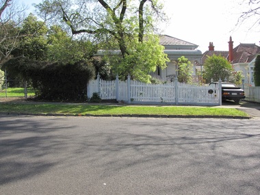
 Surrey Hills Historical Society Collection
Photograph - 4 Tower Street, Surrey Hills, The Street Where You Live Project
... Hills Neighbourhood Centre and covered the postcode 3127 in the cities of Boroondara and Whitehorse. These photos provide a snapshot of real estate in the suburbs of Mont Albert and Surrey Hills during a period of rapid change with many properties on large blocks demolished to create higher density residential development or renewal of single dwellings. At particular risk were properties not covered by heritage overlays, in particular interwar housing and post 1950's housing. The Street Where You Live Project Photograph 4 Tower ...Photos documenting this address as part of a photographic series undertaken by volunteer photographers during 2013 and 2014 for The Street Where You Live Project. This was organised through the Surrey Hills Neighbourhood Centre and covered the postcode 3127 in the cities of Boroondara and Whitehorse.These photos provide a snapshot of real estate in the suburbs of Mont Albert and Surrey Hills during a period of rapid change with many properties on large blocks demolished to create higher density residential development or renewal of single dwellings. At particular risk were properties not covered by heritage overlays, in particular interwar housing and post 1950's housing. -
 Surrey Hills Historical Society Collection
Photograph - 7 Tower Street, Surrey Hills, The Street Where You Live Project
... Hills Neighbourhood Centre and covered the postcode 3127 in the cities of Boroondara and Whitehorse. These photos provide a snapshot of real estate in the suburbs of Mont Albert and Surrey Hills during a period of rapid change with many properties on large blocks demolished to create higher density residential development or renewal of single dwellings. At particular risk were properties not covered by heritage overlays, in particular interwar housing and post 1950's housing. The Street Where You Live Project Photograph 7 Tower ...Photos documenting this address as part of a photographic series undertaken by volunteer photographers during 2013 and 2014 for The Street Where You Live Project. This was organised through the Surrey Hills Neighbourhood Centre and covered the postcode 3127 in the cities of Boroondara and Whitehorse.These photos provide a snapshot of real estate in the suburbs of Mont Albert and Surrey Hills during a period of rapid change with many properties on large blocks demolished to create higher density residential development or renewal of single dwellings. At particular risk were properties not covered by heritage overlays, in particular interwar housing and post 1950's housing. -
 Surrey Hills Historical Society Collection
Photograph - 9 Tower Street, Surrey Hills, The Street Where You Live Project
... Hills Neighbourhood Centre and covered the postcode 3127 in the cities of Boroondara and Whitehorse. These photos provide a snapshot of real estate in the suburbs of Mont Albert and Surrey Hills during a period of rapid change with many properties on large blocks demolished to create higher density residential development or renewal of single dwellings. At particular risk were properties not covered by heritage overlays, in particular interwar housing and post 1950's housing. The Street Where You Live Project Photograph 9 Tower ...Photos documenting this address as part of a photographic series undertaken by volunteer photographers during 2013 and 2014 for The Street Where You Live Project. This was organised through the Surrey Hills Neighbourhood Centre and covered the postcode 3127 in the cities of Boroondara and Whitehorse.These photos provide a snapshot of real estate in the suburbs of Mont Albert and Surrey Hills during a period of rapid change with many properties on large blocks demolished to create higher density residential development or renewal of single dwellings. At particular risk were properties not covered by heritage overlays, in particular interwar housing and post 1950's housing. -
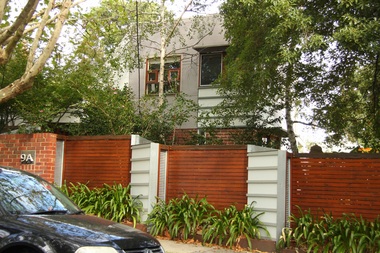 Surrey Hills Historical Society Collection
Photograph - 9A Tower Street, Surrey Hills, The Street Where You Live Project
... Hills Neighbourhood Centre and covered the postcode 3127 in the cities of Boroondara and Whitehorse. These photos provide a snapshot of real estate in the suburbs of Mont Albert and Surrey Hills during a period of rapid change with many properties on large blocks demolished to create higher density residential development or renewal of single dwellings. At particular risk were properties not covered by heritage overlays, in particular interwar housing and post 1950's housing. The Street Where You Live Project Photograph 9A Tower ...Photos documenting this address as part of a photographic series undertaken by volunteer photographers during 2013 and 2014 for The Street Where You Live Project. This was organised through the Surrey Hills Neighbourhood Centre and covered the postcode 3127 in the cities of Boroondara and Whitehorse.These photos provide a snapshot of real estate in the suburbs of Mont Albert and Surrey Hills during a period of rapid change with many properties on large blocks demolished to create higher density residential development or renewal of single dwellings. At particular risk were properties not covered by heritage overlays, in particular interwar housing and post 1950's housing. -
 Surrey Hills Historical Society Collection
Photograph - 11 Tower Street, Surrey Hills, The Street Where You Live Project
... Hills Neighbourhood Centre and covered the postcode 3127 in the cities of Boroondara and Whitehorse. These photos provide a snapshot of real estate in the suburbs of Mont Albert and Surrey Hills during a period of rapid change with many properties on large blocks demolished to create higher density residential development or renewal of single dwellings. At particular risk were properties not covered by heritage overlays, in particular interwar housing and post 1950's housing. The Street Where You Live Project Photograph 11 Tower ...Photos documenting this address as part of a photographic series undertaken by volunteer photographers during 2013 and 2014 for The Street Where You Live Project. This was organised through the Surrey Hills Neighbourhood Centre and covered the postcode 3127 in the cities of Boroondara and Whitehorse.These photos provide a snapshot of real estate in the suburbs of Mont Albert and Surrey Hills during a period of rapid change with many properties on large blocks demolished to create higher density residential development or renewal of single dwellings. At particular risk were properties not covered by heritage overlays, in particular interwar housing and post 1950's housing. -
 Surrey Hills Historical Society Collection
Photograph - 11A Tower Street, Surrey Hills, The Street Where You Live Project
... Hills Neighbourhood Centre and covered the postcode 3127 in the cities of Boroondara and Whitehorse. These photos provide a snapshot of real estate in the suburbs of Mont Albert and Surrey Hills during a period of rapid change with many properties on large blocks demolished to create higher density residential development or renewal of single dwellings. At particular risk were properties not covered by heritage overlays, in particular interwar housing and post 1950's housing. The Street Where You Live Project Photograph 11A Tower ...Photos documenting this address as part of a photographic series undertaken by volunteer photographers during 2013 and 2014 for The Street Where You Live Project. This was organised through the Surrey Hills Neighbourhood Centre and covered the postcode 3127 in the cities of Boroondara and Whitehorse.These photos provide a snapshot of real estate in the suburbs of Mont Albert and Surrey Hills during a period of rapid change with many properties on large blocks demolished to create higher density residential development or renewal of single dwellings. At particular risk were properties not covered by heritage overlays, in particular interwar housing and post 1950's housing. -
 Surrey Hills Historical Society Collection
Photograph - 13 Tower Street, Surrey Hills, The Street Where You Live Project
... Hills Neighbourhood Centre and covered the postcode 3127 in the cities of Boroondara and Whitehorse. These photos provide a snapshot of real estate in the suburbs of Mont Albert and Surrey Hills during a period of rapid change with many properties on large blocks demolished to create higher density residential development or renewal of single dwellings. At particular risk were properties not covered by heritage overlays, in particular interwar housing and post 1950's housing. The Street Where You Live Project Photograph 13 Tower ...Photos documenting this address as part of a photographic series undertaken by volunteer photographers during 2013 and 2014 for The Street Where You Live Project. This was organised through the Surrey Hills Neighbourhood Centre and covered the postcode 3127 in the cities of Boroondara and Whitehorse.These photos provide a snapshot of real estate in the suburbs of Mont Albert and Surrey Hills during a period of rapid change with many properties on large blocks demolished to create higher density residential development or renewal of single dwellings. At particular risk were properties not covered by heritage overlays, in particular interwar housing and post 1950's housing. -
 Surrey Hills Historical Society Collection
Photograph - 15 Tower Street, Surrey Hills, The Street Where You Live Project
... Hills Neighbourhood Centre and covered the postcode 3127 in the cities of Boroondara and Whitehorse. These photos provide a snapshot of real estate in the suburbs of Mont Albert and Surrey Hills during a period of rapid change with many properties on large blocks demolished to create higher density residential development or renewal of single dwellings. At particular risk were properties not covered by heritage overlays, in particular interwar housing and post 1950's housing. The Street Where You Live Project Photograph 15 Tower ...Photos documenting this address as part of a photographic series undertaken by volunteer photographers during 2013 and 2014 for The Street Where You Live Project. This was organised through the Surrey Hills Neighbourhood Centre and covered the postcode 3127 in the cities of Boroondara and Whitehorse.These photos provide a snapshot of real estate in the suburbs of Mont Albert and Surrey Hills during a period of rapid change with many properties on large blocks demolished to create higher density residential development or renewal of single dwellings. At particular risk were properties not covered by heritage overlays, in particular interwar housing and post 1950's housing. -
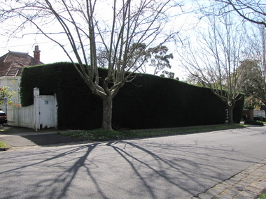
 Surrey Hills Historical Society Collection
Photograph - 16 Tower Street, Surrey Hills, The Street Where You Live Project
... Hills Neighbourhood Centre and covered the postcode 3127 in the cities of Boroondara and Whitehorse. These photos provide a snapshot of real estate in the suburbs of Mont Albert and Surrey Hills during a period of rapid change with many properties on large blocks demolished to create higher density residential development or renewal of single dwellings. At particular risk were properties not covered by heritage overlays, in particular interwar housing and post 1950's housing. The Street Where You Live Project Photograph 16 Tower ...Photos documenting this address as part of a photographic series undertaken by volunteer photographers during 2013 and 2014 for The Street Where You Live Project. This was organised through the Surrey Hills Neighbourhood Centre and covered the postcode 3127 in the cities of Boroondara and Whitehorse.These photos provide a snapshot of real estate in the suburbs of Mont Albert and Surrey Hills during a period of rapid change with many properties on large blocks demolished to create higher density residential development or renewal of single dwellings. At particular risk were properties not covered by heritage overlays, in particular interwar housing and post 1950's housing. -
 Surrey Hills Historical Society Collection
Photograph - 17 Tower Street, Surrey Hills, The Street Where You Live Project
... Hills Neighbourhood Centre and covered the postcode 3127 in the cities of Boroondara and Whitehorse. These photos provide a snapshot of real estate in the suburbs of Mont Albert and Surrey Hills during a period of rapid change with many properties on large blocks demolished to create higher density residential development or renewal of single dwellings. At particular risk were properties not covered by heritage overlays, in particular interwar housing and post 1950's housing. The Street Where You Live Project Photograph 17 Tower ...Photos documenting this address as part of a photographic series undertaken by volunteer photographers during 2013 and 2014 for The Street Where You Live Project. This was organised through the Surrey Hills Neighbourhood Centre and covered the postcode 3127 in the cities of Boroondara and Whitehorse.These photos provide a snapshot of real estate in the suburbs of Mont Albert and Surrey Hills during a period of rapid change with many properties on large blocks demolished to create higher density residential development or renewal of single dwellings. At particular risk were properties not covered by heritage overlays, in particular interwar housing and post 1950's housing. -
 Surrey Hills Historical Society Collection
Photograph - 18 Tower Street, Surrey Hills, The Street Where You Live Project
... Hills Neighbourhood Centre and covered the postcode 3127 in the cities of Boroondara and Whitehorse. These photos provide a snapshot of real estate in the suburbs of Mont Albert and Surrey Hills during a period of rapid change with many properties on large blocks demolished to create higher density residential development or renewal of single dwellings. At particular risk were properties not covered by heritage overlays, in particular interwar housing and post 1950's housing. The Street Where You Live Project Photograph 18 Tower ...Photos documenting this address as part of a photographic series undertaken by volunteer photographers during 2013 and 2014 for The Street Where You Live Project. This was organised through the Surrey Hills Neighbourhood Centre and covered the postcode 3127 in the cities of Boroondara and Whitehorse.These photos provide a snapshot of real estate in the suburbs of Mont Albert and Surrey Hills during a period of rapid change with many properties on large blocks demolished to create higher density residential development or renewal of single dwellings. At particular risk were properties not covered by heritage overlays, in particular interwar housing and post 1950's housing. -
 Surrey Hills Historical Society Collection
Photograph - 20 Tower Street, Surrey Hills, The Street Where You Live Project
... Hills Neighbourhood Centre and covered the postcode 3127 in the cities of Boroondara and Whitehorse. These photos provide a snapshot of real estate in the suburbs of Mont Albert and Surrey Hills during a period of rapid change with many properties on large blocks demolished to create higher density residential development or renewal of single dwellings. At particular risk were properties not covered by heritage overlays, in particular interwar housing and post 1950's housing. The Street Where You Live Project Photograph 20 Tower ...Photos documenting this address as part of a photographic series undertaken by volunteer photographers during 2013 and 2014 for The Street Where You Live Project. This was organised through the Surrey Hills Neighbourhood Centre and covered the postcode 3127 in the cities of Boroondara and Whitehorse.These photos provide a snapshot of real estate in the suburbs of Mont Albert and Surrey Hills during a period of rapid change with many properties on large blocks demolished to create higher density residential development or renewal of single dwellings. At particular risk were properties not covered by heritage overlays, in particular interwar housing and post 1950's housing. -
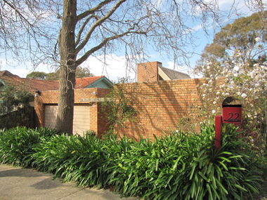
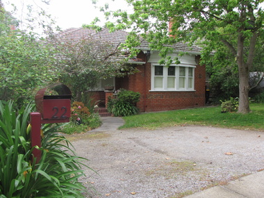 Surrey Hills Historical Society Collection
Photograph - 22 Tower Street, Surrey Hills, The Street Where You Live Project
... Hills Neighbourhood Centre and covered the postcode 3127 in the cities of Boroondara and Whitehorse. These photos provide a snapshot of real estate in the suburbs of Mont Albert and Surrey Hills during a period of rapid change with many properties on large blocks demolished to create higher density residential development or renewal of single dwellings. At particular risk were properties not covered by heritage overlays, in particular interwar housing and post 1950's housing. The Street Where You Live Project Photograph 22 Tower ...Photos documenting this address as part of a photographic series undertaken by volunteer photographers during 2013 and 2014 for The Street Where You Live Project. This was organised through the Surrey Hills Neighbourhood Centre and covered the postcode 3127 in the cities of Boroondara and Whitehorse.These photos provide a snapshot of real estate in the suburbs of Mont Albert and Surrey Hills during a period of rapid change with many properties on large blocks demolished to create higher density residential development or renewal of single dwellings. At particular risk were properties not covered by heritage overlays, in particular interwar housing and post 1950's housing. -
 Surrey Hills Historical Society Collection
Photograph - 24 Tower Street, Surrey Hills, The Street Where You Live Project
... Hills Neighbourhood Centre and covered the postcode 3127 in the cities of Boroondara and Whitehorse. These photos provide a snapshot of real estate in the suburbs of Mont Albert and Surrey Hills during a period of rapid change with many properties on large blocks demolished to create higher density residential development or renewal of single dwellings. At particular risk were properties not covered by heritage overlays, in particular interwar housing and post 1950's housing. The Street Where You Live Project Photograph 24 Tower ...Photos documenting this address as part of a photographic series undertaken by volunteer photographers during 2013 and 2014 for The Street Where You Live Project. This was organised through the Surrey Hills Neighbourhood Centre and covered the postcode 3127 in the cities of Boroondara and Whitehorse.These photos provide a snapshot of real estate in the suburbs of Mont Albert and Surrey Hills during a period of rapid change with many properties on large blocks demolished to create higher density residential development or renewal of single dwellings. At particular risk were properties not covered by heritage overlays, in particular interwar housing and post 1950's housing. -
 Surrey Hills Historical Society Collection
Photograph - 26 Tower Street, Surrey Hills, The Street Where You Live Project
... Hills Neighbourhood Centre and covered the postcode 3127 in the cities of Boroondara and Whitehorse. These photos provide a snapshot of real estate in the suburbs of Mont Albert and Surrey Hills during a period of rapid change with many properties on large blocks demolished to create higher density residential development or renewal of single dwellings. At particular risk were properties not covered by heritage overlays, in particular interwar housing and post 1950's housing. The Street Where You Live Project Photograph 26 Tower ...Photos documenting this address as part of a photographic series undertaken by volunteer photographers during 2013 and 2014 for The Street Where You Live Project. This was organised through the Surrey Hills Neighbourhood Centre and covered the postcode 3127 in the cities of Boroondara and Whitehorse.These photos provide a snapshot of real estate in the suburbs of Mont Albert and Surrey Hills during a period of rapid change with many properties on large blocks demolished to create higher density residential development or renewal of single dwellings. At particular risk were properties not covered by heritage overlays, in particular interwar housing and post 1950's housing.