Showing 18 items matching "towns of victoria names named from to"
-
 Bendigo Historical Society Inc.
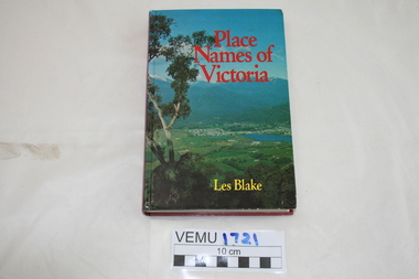
Book - PLACE NAMES OF VICTORIA
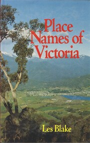
... ...Towns of Victoria names named from to...History House 11 Mackenzie Street Bendigo goldfields BOOK place names Towns of Victoria names named from to Les Blake Place Names of Victoria. ...Place Names of Victoria. First Published 1977. Author: Leslie Bamford James Blake, 1913. Publisher: Rigby Ltd, Melbourne. ISBN: 0 7270 07270 3. Photographs. 294 pages. Inscriptions/Markings; autographed by Les Blake, Bendigo Historiacl Society stamp inside front cover.Les Blakebook, place names, towns of victoria names named from to -
 Emerald Museum & Nobelius Heritage Park
Book, Place Names of Victoria, 1977
... naming was a chronological representative of land discovery and settlement. Starting from the native population to the explorers, the squatters and settlers and surveyors during the gold rush. The term 'places' refers to physical features of the coast and land as well as districts, towns and cities. Place Names of Victoria Hard Cover book written by Les Blake and first published in 1977. The jacket has a photograph of Mount Beauty and the Kiewa Valley from the Tawonga Gap. Place Names ...The sequence of naming was a chronological representative of land discovery and settlement. Starting from the native population to the explorers, the squatters and settlers and surveyors during the gold rush. The term 'places' refers to physical features of the coast and land as well as districts, towns and cities.Hard Cover book written by Les Blake and first published in 1977. The jacket has a photograph of Mount Beauty and the Kiewa Valley from the Tawonga Gap.place names of victoria -
 Eltham District Historical Society Inc
Photograph - Digital Photograph, Marguerite Marshall, 'Landscape', 60 Lavender Park Road, Eltham South, 24 June 2008
... town. The art gallery in Main Road Eltham was named Wiregrass in Leason’s honour. Leason completed 1000 drawings from 1919 to 1937, which author Garrie Hutchinson claimed, were technically unsurpassed and had regional and universal interest. Leason’s acute observations of country life stemmed from his childhood in Kaniva in Victoria’s western Wimmera, where he was born, the son of a selector, in 1889. Meldrum claimed that Leason could name...town. The art gallery in Main Road Eltham was named Wiregrass in Leason’s honour. Leason completed 1000 drawings from 1919 to 1937, which author Garrie Hutchinson claimed, were technically unsurpassed and had regional and universal interest. Leason’s acute observations of country life stemmed from his childhood in Kaniva in Victoria’s western Wimmera, where he was born, the son of a selector, in 1889. Meldrum claimed that Leason could name ...Built by artist and cartoonist Percy Leason in 1927 in what was then New Street but renamed Lavender Park Road in the late 1950s/early 1960s. Covered under Heritage Overlay, Nillumbik Planning Scheme. Published: Nillumbik Now and Then / Marguerite Marshall 2008; photographs Alan King with Marguerite Marshall.; p121 Said to be a genius, cartoonist Percy Leason’s career was at its peak when in 1925 to 1926 he built his home at New Street (now Lavender Park Road) Eltham. The Herald newspaper owner, Sir Keith Murdoch, had hired Leason for his newly acquired Melbourne Punch magazine at a salary of £1750, making him ‘one of the highest paid cartoonists in the world’.1 With this salary and financial help from Murdoch, Leason was able to build his lovely home in Eltham. At the crest of a sweeping drive, the home now two-storey in white brick with a gabled grey slate roof and dormer windows is flanked by an extension built by another owner in the 1980s. Leason lived in the home with his wife, Isabel and children, until 1937, when he left for the United States of America, where he lived until his death in 1959. The four-bedroom house and garden would have been well-suited to bringing up his family and to entertaining their friends in style. Large airy rooms have high ceilings with moulded plaster, timber floors and several are brightened with bay windows. Leason made friends with many of the artists and personalities who gravitated to Eltham. Around 1931 Justus Jörgensen, founder of the Montsalvat Artists’ Colony, helped Leason build his large studio at the back of the house. Another friend was journalist Mervyn Skipper, father of jeweller and sculptor Matcham, and artists Helen and Sonia. Leason’s teacher, artist Max Meldrum, also visited and rented accommodation in Eltham, opposite Wingrove Park. Punch folded in 1925, but Leason continued as cartoonist for Table Talk. In 1926 Leason began the cartoons of a mythical Australian town Wiregrass, which were inspired by Kaniva, his home town. The art gallery in Main Road Eltham was named Wiregrass in Leason’s honour. Leason completed 1000 drawings from 1919 to 1937, which author Garrie Hutchinson claimed, were technically unsurpassed and had regional and universal interest. Leason’s acute observations of country life stemmed from his childhood in Kaniva in Victoria’s western Wimmera, where he was born, the son of a selector, in 1889. Meldrum claimed that Leason could name every plant and the habits of every animal.2 Leason also painted 28 portraits of the last full-blooded aboriginals in Victoria at Lake Tyers in Gippsland, most of which are in a private collection. In Sydney Leason illustrated Henry Lawson’s Selected Poems and worked for The Bulletin. Leason had begun his career at 13 as an apprentice lithographic artist at Sands and MacDougall. He attended night classes at the National Gallery and the Victorian Artists Society. Leason first visited Eltham in 1910 to paint with fellow artist William ‘Jock’ Frater. They camped near Bible and Pitt Streets and along the Diamond Creek on the site of the present Eltham Retirement Centre. Despite his success as a cartoonist, Leason wanted to be recognised as a serious painter and for his anthropological work.3 He was also conservative and felt uncomfortable with the modern art scene in Melbourne.4 So he left for the United States of America to work as a painter. Ironically his time in New York saw the burgeoning of modern art, notably by artists such as Jackson Pollock. But Leason found his niche by running an art school, painting society portraits and illustrating books and magazines.This collection of almost 130 photos about places and people within the Shire of Nillumbik, an urban and rural municipality in Melbourne's north, contributes to an understanding of the history of the Shire. Published in 2008 immediately prior to the Black Saturday bushfires of February 7, 2009, it documents sites that were impacted, and in some cases destroyed by the fires. It includes photographs taken especially for the publication, creating a unique time capsule representing the Shire in the early 21st century. It remains the most recent comprehenesive publication devoted to the Shire's history connecting local residents to the past. nillumbik now and then (marshall-king) collection, landscape, lavender park road, percy leason, new street -
 Flagstaff Hill Maritime Museum and Village
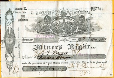
Document - Permit, Miner's Right, 1888
... Victoria. The Warrnambool correspondent of the “Hamilton Spectator”, 31/1/1878, p4 attest to the price of a good season of potatoes comparing “favourably with the unsteady returns of any precarious gold-bearing quartz reefs in the colony.” The Miner's Wright is issued to -- Bryant. While it cannot be found who this Bryant is, the name Bryant is historical to the town of Warrnambool which has a street named after William Bryant the first head teacher of the Jamieson Street Primary School from 1876 to 1894. ...Victoria. The Warrnambool correspondent of the “Hamilton Spectator”, 31/1/1878, p4 attest to the price of a good season of potatoes comparing “favourably with the unsteady returns of any precarious gold-bearing quartz reefs in the colony.” The Miner's Wright is issued to -- Bryant. While it cannot be found who this Bryant is, the name Bryant is historical to the town of Warrnambool which has a street named after William Bryant the first head teacher of the Jamieson Street Primary School from 1876 to 1894. ...This Miner’s Right was issued post the rush of the 1850s-60s but is testament to the ongoing interest in gold although the great rush had dwindled. Local papers continued to report on findings and hopes of success, including syndicates and explorations across the south-west district of Victoria and Otway Region, Victoria. The Warrnambool correspondent of the “Hamilton Spectator”, 31/1/1878, p4 attest to the price of a good season of potatoes comparing “favourably with the unsteady returns of any precarious gold-bearing quartz reefs in the colony.” The Miner's Wright is issued to -- Bryant. While it cannot be found who this Bryant is, the name Bryant is historical to the town of Warrnambool which has a street named after William Bryant the first head teacher of the Jamieson Street Primary School from 1876 to 1894. Numerous newspapers of the day reported the movement of local residents moving to other regions with varying success of gold prospecting. This item is significant in that it illustrates that people associated with the region were interested in taking their chances in prospecting for gold similar to many others. A lure that is still present for some today. Although the southwest region found it's source of wealth in other industries from whaling and fishing, wool and other agricultural pursuits.Top to bottom upright Miner’s Right. “Series I. Book No. 2. Five Shillings. No. 144. Colony of Victoria” Issued in Ballarat, date 16th June 1888 to “[looks like] J. V. Bryant”. A previous name is scribbled through and looks like Christine, second name not deciphered. The document is in force until “15th June 1889”. “The Mining Statute 1865”. Authorised signature last name Bennet. The paper is buff and has some slight ink markings and finger smudges. A coat of arms appears at the top centre. Another insignia related to mining with a pick and shovel, set of scales and the initial “VR” goes down the lefthand side of the page. This page has a serrated edge. The ink on the page is black, and the words “BALLARAT” are stamped in red ink, now faded. All hand writing is black script. There are no “particulars of registration” given in the spaces provided on the back of the document. Series I. Book No. 2. No. 144. Ballarat. 16th Jume 1888 to 15th June 1889. Colony of Victoria "The Mining Statue 1865, No. 291.flagstaff hill, warrnambool, shipwrecked coast, flagstaff hill maritime museum, maritime museum, shipwreck coast, flagstaff hill maritime village, great ocean road, james collins, australian goldfields, miner's rights, the history of ballarat, gold rush, bryant -
 Marysville & District Historical Society
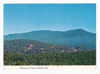
Postcard (item) - Colour postcard, Nucolorvue Productions Pty. Ltd, Panoramic View of Marysville, Pre 2009
... town in the 1940s. Timber mill owners A Cameron and FJ Barton named Cambarville. They established the mill to salvage timber from trees destroyed in the 1939 bushfires. Cambarville was impacted by the 2009 Black Saturday bushfires and any remaining structures were destroyed. Barton's Lookout was named after a member of the Barton Family who were amongst Marysville's earliest pioneering families. This postcard was produced by Nucolorvue Productions as a souvenir of Marysville. marysville barton's lookout victoria ...A colour photograph of the view of Marysville from Barton's Lookout which is near the Cumberland Valley in Victoria.A colour photograph of the view of Marysville from Barton's Lookout which is near the Cumberland Valley in Victoria. The Cumberland Valley is notable for its giant mountain ash (Eucalyptus regnans) trees within the Cumberland Memorial Scenic Reserve, and relics from former sawmills and gold mining. The Big Culvert is located nearby on the Marysville-Woods Point Road, which was historically part of the Yarra Track. Cambarville, which is in the Cumberland Valley, was established as a timber mill town in the 1940s. Timber mill owners A Cameron and FJ Barton named Cambarville. They established the mill to salvage timber from trees destroyed in the 1939 bushfires. Cambarville was impacted by the 2009 Black Saturday bushfires and any remaining structures were destroyed. Barton's Lookout was named after a member of the Barton Family who were amongst Marysville's earliest pioneering families. This postcard was produced by Nucolorvue Productions as a souvenir of Marysville.NU-COLOR-VUE/ OF/ AUSTRALIA MARYSVILLE, VICTORIA Panoramic View of Marysville from/ CUMBERLAND. PLACE/ STAMP/ HERE POST CARD NUC.171 - NUCOLORVUE PRODUCTIONS PTY. LTD./ COPYRIGHT Printed in Australiamarysville, barton's lookout, victoria, nucolorvue productions, postcard, souvenir, cumberland valley, cumberland memorial scenic reserve, big culvert, marysville-wood's point road, yarra track, mining, timber mills, a cameron, fj barton, cambarville, 1939 bushfires, 2009 black saturday bushfires -
 Marysville & District Historical Society
Postcard (item) - Colour postcard, Nucolorvue Productions Pty. Ltd, Panoramic View of Marysville, Pre 2009
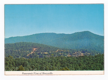
... town in the 1940s. Timber mill owners A Cameron and FJ Barton named Cambarville. They established the mill to salvage timber from trees destroyed in the 1939 bushfires. Cambarville was impacted by the 2009 Black Saturday bushfires and any remaining structures were destroyed. Barton's Lookout was named after a member of the Barton Family who were amongst Marysville's earliest pioneering families. This postcard was produced by Nucolorvue Productions as a souvenir of Marysville. marysville barton's lookout victoria ...A colour photograph of the view of Marysville from Barton's Lookout which is near the Cumberland Valley in Victoria.A colour photograph of the view of Marysville from Barton's Lookout which is near the Cumberland Valley in Victoria. The Cumberland Valley is notable for its giant mountain ash (Eucalyptus regnans) trees within the Cumberland Memorial Scenic Reserve, and relics from former sawmills and gold mining. The Big Culvert is located nearby on the Marysville-Woods Point Road, which was historically part of the Yarra Track. Cambarville, which is in the Cumberland Valley, was established as a timber mill town in the 1940s. Timber mill owners A Cameron and FJ Barton named Cambarville. They established the mill to salvage timber from trees destroyed in the 1939 bushfires. Cambarville was impacted by the 2009 Black Saturday bushfires and any remaining structures were destroyed. Barton's Lookout was named after a member of the Barton Family who were amongst Marysville's earliest pioneering families. This postcard was produced by Nucolorvue Productions as a souvenir of Marysville.NU-COLOR-VUE/ OF/ AUSTRALIA MARYSVILLE, VICTORIA Panoramic View of Marysville from/ CUMBERLAND. PLACE/ STAMP/ HERE POST CARD NUC.171 - NUCOLORVUE PRODUCTIONS PTY. LTD./ COPYRIGHT Printed in Australia Hi There! how are you? fine I hope....Hows school/ treating you?/ Isn't it beautiful now Autumns back again./ You'll have to come up soon and see us, where/ really you/ Ok! it beautiful, the air so fresh and/ clean it makes you want to cry. There are/ so many magnificent and brill marysville, barton's lookout, victoria, nucolorvue productions, postcard, souvenir, cumberland valley, cumberland memorial scenic reserve, big culvert, marysville-wood's point road, yarra track, mining, timber mills, a cameron, fj barton, cambarville, 1939 bushfires, 2009 black saturday bushfires -
 Marysville & District Historical Society
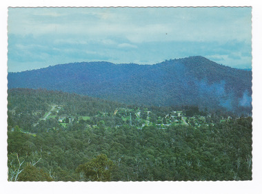
Postcard (item) - Colour postcard, Nucolorvue Productions Pty. Ltd, MARYSVILLE-Victoria, Pre 2009
... town in the 1940s. Timber mill owners A Cameron and FJ Barton named Cambarville. They established the mill to salvage timber from trees destroyed in the 1939 bushfires. Cambarville was impacted by the 2009 Black Saturday bushfires and any remaining structures were destroyed. Barton's Lookout was named after a member of the Barton Family who were amongst Marysville's earliest pioneering families. This postcard was produced by Nucolorvue Productions as a souvenir of Marysville. marysville barton's lookout victoria ...A colour photograph of the view of Marysville from the Cumberland Range.A colour photograph of the view of Marysville from the Cumberland Range.The Cumberland Valley is notable for its giant mountain ash (Eucalyptus regnans) trees within the Cumberland Memorial Scenic Reserve, and relics from former sawmills and gold mining. The Big Culvert is located nearby on the Marysville-Woods Point Road, which was historically part of the Yarra Track. Cambarville, which is in the Cumberland Valley, was established as a timber mill town in the 1940s. Timber mill owners A Cameron and FJ Barton named Cambarville. They established the mill to salvage timber from trees destroyed in the 1939 bushfires. Cambarville was impacted by the 2009 Black Saturday bushfires and any remaining structures were destroyed. Barton's Lookout was named after a member of the Barton Family who were amongst Marysville's earliest pioneering families. This postcard was produced by Nucolorvue Productions as a souvenir of Marysville.Panorama of Marysville from/ Cumberland Range. NU-COLOR-VUE/ OF/ AUSTRALIA NUCOLORVUE PRODUCTIONS PTY. LTD./ COPYRIGHT PRINTED IN AUSTRALIA NCV 1658 POST CARD Dear Anne & tribe,/ Well as you can see,/ I'm here at Marysville./ This little surprise/ was waiting for me/ at the airport. We're/ here for a few days,/ & it's in the mountains/ outside Melb./ Traditionally it's/ a spot for Honeymooners./ There are lots of/ bush tracks &/ places to see and/ the hotel has a pool./ The weather is hot,/ 42 today so it/ is lovely to be out/ of Melb./ bye for now/ all my love/ illegiblemarysville, barton's lookout, victoria, nucolorvue productions, postcard, souvenir, cumberland valley, cumberland memorial scenic reserve, big culvert, marysville-wood's point road, yarra track, mining, timber mills, a cameron, fj barton, cambarville, 1939 bushfires, 2009 black saturday bushfires -
 Marysville & District Historical Society
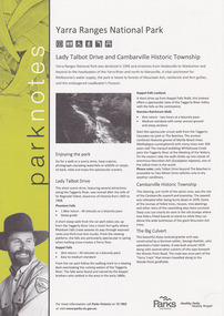
Flyer (item) - Information Flyer, Parks Victoria, park notes-Yarra Ranges National Park-Lady Talbot Drive and Cambarville Historic Township, June 2013
... named after Lady Sarah Elizabeth, the wife of Sir Reginald Talbot, who was the Governor of Victoria from 25th April, 1904 to 6th July 1908. Cambarville is notable for its giant mountain ash (Eucalyptus regnans) trees within the Cumberland Memorial Scenic Reserve, and relics from former sawmills and gold mining. The Big Culvert is located nearby on the Marysville-Woods Point Road, which was historically part of the Yarra Track. Cambarville was established as a timber mill town in the 1940s. Timber mill owners A Cameron and FJ Barton named ...A flyer produced by Parks Victoria of information on Lady Talbot Drive and Cambarville Historic Township.A flyer produced by Parks Victoria of information on Lady Talbot Drive and Cambarville Historic Township. Lady Talbot Drive a 24 kilometer scenic rainforest car journey which passes a number of walks and waterfalls in the Yarra Ranges National Park. Lady Talbot Drive is named after Lady Sarah Elizabeth, the wife of Sir Reginald Talbot, who was the Governor of Victoria from 25th April, 1904 to 6th July 1908. Cambarville is notable for its giant mountain ash (Eucalyptus regnans) trees within the Cumberland Memorial Scenic Reserve, and relics from former sawmills and gold mining. The Big Culvert is located nearby on the Marysville-Woods Point Road, which was historically part of the Yarra Track. Cambarville was established as a timber mill town in the 1940s. Timber mill owners A Cameron and FJ Barton named Cambarville. They established the mill to salvage timber from trees destroyed in the 1939 bushfires. Cambarville was impacted by the 2009 Black Saturday bushfires and any remaining structures were destroyed. parks victoria, yarra ranges national park, lady talbot drive, lady talbot forest drive, cambarville, taggerty river, sir reginald talbot, lady sarah elizabeth talbot, phantom falls, keppel falls, keppel falls lookout, beeches rainforest walk, big culvert, cumberland walk, the big tree, the sitka spruce, cora lynn falls, sovereign view -
 Marysville & District Historical Society
Flyer (item) - Information Flyer, Parks Victoria, Yarra Ranges National Park-Lady Talbot Drive, Cambarville and Lake Mountain-Visitor Guide, 01-2018
... named after Lady Sarah Elizabeth, the wife of Sir Reginald Talbot, who was the Governor of Victoria from 25th April, 1904 to 6th July 1908. Cambarville is notable for its giant mountain ash (Eucalyptus regnans) trees within the Cumberland Memorial Scenic Reserve, and relics from former sawmills and gold mining. The Big Culvert is located nearby on the Marysville-Woods Point Road, which was historically part of the Yarra Track. Cambarville was established as a timber mill town in the 1940s. Timber mill owners A Cameron and FJ Barton named ...A flyer that was produced as a guide to Lady Talbot Drive, Cambarville and Lake Mountain.A flyer that was produced as a guide to Lady Talbot Drive, Cambarville and Lake Mountain. Lady Talbot Drive a 24 kilometer scenic rainforest car journey which passes a number of walks and waterfalls in the Yarra Ranges National Park. Lady Talbot Drive is named after Lady Sarah Elizabeth, the wife of Sir Reginald Talbot, who was the Governor of Victoria from 25th April, 1904 to 6th July 1908. Cambarville is notable for its giant mountain ash (Eucalyptus regnans) trees within the Cumberland Memorial Scenic Reserve, and relics from former sawmills and gold mining. The Big Culvert is located nearby on the Marysville-Woods Point Road, which was historically part of the Yarra Track. Cambarville was established as a timber mill town in the 1940s. Timber mill owners A Cameron and FJ Barton named Cambarville. They established the mill to salvage timber from trees destroyed in the 1939 bushfires. Cambarville was impacted by the 2009 Black Saturday bushfires and any remaining structures were destroyed. Lake Mountain is the closest alpine cross-country ski resort to Melbourne.lady talbot drive, lady talbot forest drive, cambarville, lake mountain, sir reginald talbot, lady sarah elizabeth talbot -
 Buninyong & District Historical Society
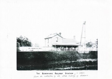
Print - Black and white copy of Yendon (Buninyong) Station c1860s, The Buninyong Railway Station
... Town Hall 313 Learmonth Street Buninyong goldfields Yendon Railway Station, built 1862 as Buninyong (East) Station. Yendon No.1 and No. 2 Roads constructed to connect cab service with the township of Buninyong. The station name was changed to Yendon 1878. This image illustrates The Buninyong Railway Station in the 1860's on the Ballarat to Geelong line, its name was changed to Yendon Railway Station in 1878 and was demolished in 1969 Buninyong Railway Station Yendon (Buninyong East) Railway Station The Buninyong Railway Station, c 1860s from the collection of the State Library of Victoria A black and white copy of a photograph of Buninyong (Yendon) Railway Station in the 1860s The Buninyong Railway Station Print Black and white copy of Yendon (Buninyong) Station c1860s ...Yendon Railway Station, built 1862 as Buninyong (East) Station. Yendon No.1 and No. 2 Roads constructed to connect cab service with the township of Buninyong. The station name was changed to Yendon 1878.This image illustrates The Buninyong Railway Station in the 1860's on the Ballarat to Geelong line, its name was changed to Yendon Railway Station in 1878 and was demolished in 1969A black and white copy of a photograph of Buninyong (Yendon) Railway Station in the 1860sThe Buninyong Railway Station, c 1860s from the collection of the State Library of Victoriabuninyong railway station, yendon (buninyong east) railway station -
 Bayside Gallery - Bayside City Council Art & Heritage Collection
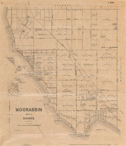
Map, Department of Crown Lands and Survey et al, Moorabbin, County of Bourke, Government Roads, 1920
... Town Clerk Sandringham from the Secretary for Department of Lands and Survey (dated 26/2/1934), notifying of dispatch of the map. The cadastral map of the Parish of Moorabbin in Victoria (L.6104) is photolithographed at the Department of Lands and Survey by W.J. Butson. It is printed in black ink on cream paper and shows street names, subdivision of blocks, sizes of the blocks and the names...Moorabbin County of Bourke Map Plan land subdivision land titles Foreshores Hampton Beaumaris Highett Cheltenham Department of Lands and Survey Land owners cartographic material Brighton Sandringham Town of Sandringham Government Roads Photolithograph of the Parish of Moorabbin (dated 17/7/1920) accompanied by original typed letter to the Town Clerk Sandringham from the Secretary for Department of Lands and Survey (dated 26/2/1934), notifying of dispatch of the map. The cadastral map of the Parish of Moorabbin in Victoria (L.6104) is photolithographed at the Department of Lands and Survey by W.J. Butson. It is printed in black ink on cream paper and shows street names, subdivision of blocks, sizes of the blocks and the names ...The cadastral map of the Parish of Moorabbin in Victoria (L.6104) shows parish boundaries and land ownership 1920 when Sandringham was a Town. The government roads have been coloured in red pencil.moorabbin, county of bourke, map, plan, land subdivision, land titles, foreshores, hampton, beaumaris, highett, cheltenham, department of lands and survey, land owners, cartographic material, brighton, sandringham, town of sandringham, government roads -
 Ruyton Girls' School
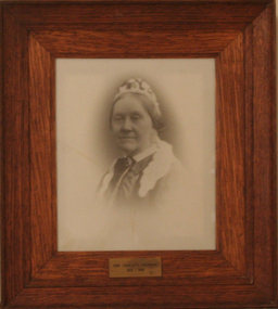
Photograph - Photographic Portrait, Mrs Charlotte Anderson
... name 'Ruyton' for the school, in honour of a connection to Ruyton-XI-Towns, Shropshire, England where her great-grandfather had been vicar and where she was baptised. In 1882 Mrs Anderson moved the School to Edgecomb in Studley Park Road from 1882-1888. The larger premises enabled her to begin accepting boarding students from 1882. She retired due to ill health and sold the school to her friend Miss Eliza Bromby. Mrs Anderson lived at 'Bongamero', in the King Valley, Victoria until her death in 1906. She is buried in Boroondara Cemetery. One of Ruyton's four Houses, Anderson, is named...name 'Ruyton' for the school, in honour of a connection to Ruyton-XI-Towns, Shropshire, England where her great-grandfather had been vicar and where she was baptised. In 1882 Mrs Anderson moved the School to Edgecomb in Studley Park Road from 1882-1888. The larger premises enabled her to begin accepting boarding students from 1882. She retired due to ill health and sold the school to her friend Miss Eliza Bromby. Mrs Anderson lived at 'Bongamero', in the King Valley, Victoria until her death in 1906. She is buried in Boroondara Cemetery. One of Ruyton's four Houses, Anderson, is named ...Mrs Charlotte Anderson was born Charlotte Eliza Alsop in England in 1838 and arrived in Australia in 1848. She married lawyer James Anderson in 1864, and in the year of his death in 1878 she became the founding owner-Principal of Ruyton Girls' School, Kew. Mrs Anderson operated Ruyton initially in her own home of 63 Bulleen Road, Kew (now 63 High Street South). According to Ruyton histories, Mrs Anderson is said to have begun the school with her own two sons, four daughters and some of her Alsop nieces and nephews who resided in Kew. Around the time of the addition of Maud King, the first student outside the family, the school changed to a 'Ladies College', and the boys were sent elsewhere for their education. By late 1881 Mrs Anderson began using the name 'Ruyton' for the school, in honour of a connection to Ruyton-XI-Towns, Shropshire, England where her great-grandfather had been vicar and where she was baptised. In 1882 Mrs Anderson moved the School to Edgecomb in Studley Park Road from 1882-1888. The larger premises enabled her to begin accepting boarding students from 1882. She retired due to ill health and sold the school to her friend Miss Eliza Bromby. Mrs Anderson lived at 'Bongamero', in the King Valley, Victoria until her death in 1906. She is buried in Boroondara Cemetery. One of Ruyton's four Houses, Anderson, is named for Charlotte Anderson. Artwork AC/0099 is a framed reproduction photograph of an original portrait of Mrs Anderson, c.1900-1906. The location and date of the original photograph is unknown, but may be held among Ruyton papers at the State Library of Victoria (MS 12079). The reproduction was probably created to be part of the gallery of Principals and significant people for the Conference/Boardroom, Henty House.A framed, black & white reproduction of a photographic portrait. The portrait shows the head and shoulders of a middle aged woman wearing Victorian-era clothing including a dark ribbon tied around her collar. She wears a lace cap on her head, and the cap's tail is draped around her shoulders. The woman's body is partially turned away from the camera, while her face is turned toward the camera. Plaque on frame: "Mrs Charlotte Anderson/ 1878-1888"charlotte anderson, ruyton, ruyton girls' school, kew (vic), bulleen road, high street south, studley park road, edgecomb, woman, school, teacher, principal, anderson, reproduction, 1990s -
 Wodonga & District Historical Society Inc
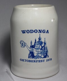
Memorabilia - Wodonga Oktoberfest Stein, c1979
... from Prussia and Bavaria to escape religious persecution. They all became actively involved in the community and made outstanding and lasting contributions to the development of the town. In the years 1868-69 more settlers arrived from South Australia and other parts of Victoria. Among the names were Heckendorf, Mueller, Zeinert and Schubert. These families were instrumental in lobbying for the establishment of the St. John's Lutheran Church in Wodonga, the foundation stone being laid in 1874. By the 1890s to the early 1900s many other Germany names...from Prussia and Bavaria to escape religious persecution. They all became actively involved in the community and made outstanding and lasting contributions to the development of the town. In the years 1868-69 more settlers arrived from South Australia and other parts of Victoria. Among the names were Heckendorf, Mueller, Zeinert and Schubert. These families were instrumental in lobbying for the establishment of the St. John's Lutheran Church in Wodonga, the foundation stone being laid in 1874. By the 1890s to the early 1900s many other Germany names ...Several German families arrived in Wodonga, usually via South Australia, in the late 1850 and 1860s. Some of the earliest settlers to arrive were the Haeusler, Schlink, Trudewind, Pfeiffer and Klinge families. Many of them had left from Prussia and Bavaria to escape religious persecution. They all became actively involved in the community and made outstanding and lasting contributions to the development of the town. In the years 1868-69 more settlers arrived from South Australia and other parts of Victoria. Among the names were Heckendorf, Mueller, Zeinert and Schubert. These families were instrumental in lobbying for the establishment of the St. John's Lutheran Church in Wodonga, the foundation stone being laid in 1874. By the 1890s to the early 1900s many other Germany names were added to the local community including Muller, Lange, Pumpa, Greschke, Lobbe, Posselt, Kreuger, Schuster, Pertzel, Star, Draper, Mueller, Semmler, Thiele, Terlich, Wegener, Schreiber and Draper. Germans continued to arrive in the area until 1914. In the great post-war migration that started through Bonegilla in December 1947, Germans were among the tens of thousands who arrived. Most of the migrants who settled in Wodonga at this time were born in Germany. According to the 2016 Census, Wodonga still has a larger percentage of people with German ancestry than most other rural communities in Victoria. The German Austrian Australian Club, Wodonga was originally formed in 1960 by immigrants to Australia, to provide a meeting place for refugees and immigrants from Europe. Oktoberfest has become a world-wide occasion for all people to share in the celebration of Bavarian traditions. The Wodonga Hospital approached the Club and asked for their involvement in holding an Oktoberfest to raise funds for the Hospital. These Fests took 11 months to organize and ended up raising over $27,000.00 for the Hospital. A large number of families of German origin have arrived in the Wodonga area from as early as the 1850s. They have made valuable and lasting contributions to the area in a range of fields including agriculture, local government, businesses, retail and medical services. Their contributions are recognised in several street names in Wodonga. A white china beer stein bearing the blue logo of the Wodonga 1979 Oktoberfest. Logo includes an image of a woman in German national costume.Above the image "WODONGA" Underneath the image "OKTOBERFEST 1979"wodonga, oktoberfest, german immigrants -
 Wodonga & District Historical Society Inc
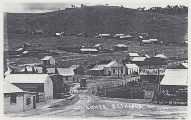
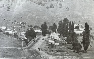
Photograph - Bethanga Township, Thomas Bonsema, c1910
... from New South Wales and other areas of Victoria. In 1875 gold was discovered there resulting in the establishment of the township named Upper Bethanga north-west of the present town of Bethanga. Four years later copper was discovered, and an adjoining settlement of miners arose, ultimately expanding to become Lower Bethanga and the present town. Our Collection includes several photographs signed BONSEMA WODONGA or sometimes simply TBW. Thomas Peter John Bonsema was born in Wodonga in 1876 to Peter John Bonsema and Mary Ann nee Nash. His name...from New South Wales and other areas of Victoria. In 1875 gold was discovered there resulting in the establishment of the township named Upper Bethanga north-west of the present town of Bethanga. Four years later copper was discovered, and an adjoining settlement of miners arose, ultimately expanding to become Lower Bethanga and the present town. Our Collection includes several photographs signed BONSEMA WODONGA or sometimes simply TBW. Thomas Peter John Bonsema was born in Wodonga in 1876 to Peter John Bonsema and Mary Ann nee Nash. His name ...The first Europeans to arrive in the area of the current township of Bethanga were explorers Hume and Hovell in 1824. In 1836 the Bethanga pastoral run was taken up by pastoralists from New South Wales and other areas of Victoria. In 1875 gold was discovered there resulting in the establishment of the township named Upper Bethanga north-west of the present town of Bethanga. Four years later copper was discovered, and an adjoining settlement of miners arose, ultimately expanding to become Lower Bethanga and the present town. Our Collection includes several photographs signed BONSEMA WODONGA or sometimes simply TBW. Thomas Peter John Bonsema was born in Wodonga in 1876 to Peter John Bonsema and Mary Ann nee Nash. His name first appears on the Electoral Roll for Wodonga in 1909 and on the Electoral Roll in 1912 he is listed as a photographer. His photographs capture many scenes and events around Wodonga and surrounding areas. Thomas Bonsema married Minna Louisa Jones in 1912. By 1914 he had moved to Chiltern, Victoria where he established Bonsema’s Photographic Studio. From this time onward many of his works bore the signature “BONSEMA CHILTERN”. As well as continuing to photograph landscapes and important buildings, Mr Bonsema was often the official photographer at school and community celebrations. He also sold many framed photographs and postcards from his premises at 68 -70 Conness Street, Chiltern. By 1943 Thomas John Bonsema had relocated to New South Wales and died in Beecroft, NSW on 14th July 1944. Some of his photographs are held in the Victorian State Library and Mitchell Library Sydney Collections.These images are significant because they are the work of a recognised photographer Thomas Bonsema who was born in Wodonga in 1876. They show the township of Bethanga near Wodonga.Three black and white images of the township of Bethanga. Photo 1 - Bethanga Photo 2 - Upper Bethanga Photo 3 - Lower Bethanga showing Harris Bros. General Storebonsema photography, thomas peter john bonsema -
 Wodonga & District Historical Society Inc
Photograph - Redelin Street, Bethanga Victoria, Thomas Bonsema, c1910
... from New South Wales and other areas of Victoria. In 1875 gold was discovered there resulting in the establishment of the township named Upper Bethanga north-west of the present town of Bethanga. Four years later copper was discovered, and an adjoining settlement of miners arose, ultimately expanding to become Lower Bethanga and the present town. Our Collection includes several photographs signed BONSEMA WODONGA or sometimes simply TBW. Thomas Peter John Bonsema was born in Wodonga in 1876 to Peter John Bonsema and Mary Ann nee Nash. His name...from New South Wales and other areas of Victoria. In 1875 gold was discovered there resulting in the establishment of the township named Upper Bethanga north-west of the present town of Bethanga. Four years later copper was discovered, and an adjoining settlement of miners arose, ultimately expanding to become Lower Bethanga and the present town. Our Collection includes several photographs signed BONSEMA WODONGA or sometimes simply TBW. Thomas Peter John Bonsema was born in Wodonga in 1876 to Peter John Bonsema and Mary Ann nee Nash. His name ...The first Europeans to arrive in the area of the current township of Bethanga were explorers Hume and Hovell in 1824. In 1836 the Bethanga pastoral run was taken up by pastoralists from New South Wales and other areas of Victoria. In 1875 gold was discovered there resulting in the establishment of the township named Upper Bethanga north-west of the present town of Bethanga. Four years later copper was discovered, and an adjoining settlement of miners arose, ultimately expanding to become Lower Bethanga and the present town. Our Collection includes several photographs signed BONSEMA WODONGA or sometimes simply TBW. Thomas Peter John Bonsema was born in Wodonga in 1876 to Peter John Bonsema and Mary Ann nee Nash. His name first appears on the Electoral Roll for Wodonga in 1909 and on the Electoral Roll in 1912 he is listed as a photographer. His photographs capture many scenes and events around Wodonga and surrounding areas. Thomas Bonsema married Minna Louisa Jones in 1912. By 1914 he had moved to Chiltern, Victoria where he established Bonsema’s Photographic Studio. From this time onward many of his works bore the signature “BONSEMA CHILTERN”. As well as continuing to photograph landscapes and important buildings, Mr Bonsema was often the official photographer at school and community celebrations. He also sold many framed photographs and postcards from his premises at 68 -70 Conness Street, Chiltern. By 1943 Thomas John Bonsema had relocated to New South Wales and died in Beecroft, NSW on 14th July 1944. Some of his photographs are held in the Victorian State Library and Mitchell Library Sydney Collections.These images are significant because they are the work of a recognised photographer Thomas Bonsema who was born in Wodonga in 1876. They show the township of Bethanga near Wodonga.An image taken from a postcard created by Thomas Bonsema. The scene is looking west towards the Gift Shaft which was mined in 1908.bonsema photography, thomas peter john bonsema -
 Ballarat Heritage Services
Photograph - Photograph - Colour, Clare Gervasoni, Tarilta, 2017, 16/07/2017
... named in 1864. Gold was discovered at Tarilta in 1853. The Tarilta School was opened in 1860 in a Wesleyan chapel, and closed i n1925. In 1864 a township was surveyed and named Tarilta, the word being derived from an Aboriginal expression thought to mean kangaroo. In 1865 Bailliere’s Victorian gazetteer described Tarilta as being an alluvial and quartz gold-mining town with three quartz-crushing mills, three horse-puddling machines and two hotels. The elevated nature of the land around Tarilta made it accessible only by horse and dray, or on horseback. tarilta central victoria ...Tarilta is a rural locality and former gold-mining town 12 km south of Castlemaine, 4 km north-west of Guildford and 3 km north-east of Vaughan. The last gold mining activity took place around the 1880s. It was originally Kangaroo Flat, being located where the Kangaroo Creek enters the Loddon River. It was surveyed and named in 1864. Gold was discovered at Tarilta in 1853. The Tarilta School was opened in 1860 in a Wesleyan chapel, and closed i n1925. In 1864 a township was surveyed and named Tarilta, the word being derived from an Aboriginal expression thought to mean kangaroo. In 1865 Bailliere’s Victorian gazetteer described Tarilta as being an alluvial and quartz gold-mining town with three quartz-crushing mills, three horse-puddling machines and two hotels. The elevated nature of the land around Tarilta made it accessible only by horse and dray, or on horseback. Colour photograph of Tarilta in Central Victoria. tarilta, central victoria, landcape -
 Hymettus Cottage & Garden Ballarat
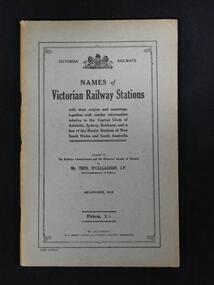
Work on paper - Booklet, Names of Victorian Railway Stations
... Hymettus Cottage & Garden Ballarat 8 Cardigan St Lake Wendouree goldfields A listing of many stations and towns that do not exist as such in the twenty-first century with an explanation of the origins and meanings of their names and a brief history. A record of many place names lost to twenty-first century students of history or railway history. Victorian Railways Stations History Victoria This 100 page booklet from ...This 100 page booklet from 1918 lists many stations and towns that do not exist as such in the twenty-first century with an explanation of the origins and meanings of the names and brief history of many. The first fifteen pages present a brief history of Victoria.non-fictionThis 100 page booklet from 1918 lists many stations and towns that do not exist as such in the twenty-first century with an explanation of the origins and meanings of the names and brief history of many. The first fifteen pages present a brief history of Victoria.victorian railways, stations, history, victoria -
 Buninyong Visitor Information Centre
Document (item) - Information Folder, Sands and McDougall, Extracts from Sands and McDougall Directory of Victoria, 1939
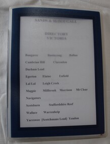
... names and occupations in towns around the Shire of Buninyong. Towns include Buninyong, Bungaree, Ballan, Cambrian Hill Clarendon, Durham Hill, Egerton, Elaine, Enfield, Lal Lal, Leigh Creek, Magpie, Millbrook, Morrisons, Mount Clear, Navigators, Scotsburn, Staffordshire Reef, Wallace, Warrenheip, Yarrowee (Scotchman's Lead), Yendon. Directories Sands & McDougall Buninyong Occupations Individuals' names handwritten on the pages. Blue plastic folder with clear front cover, containing slip pages with photocopies of pages from the 1938 and 1959 Sands and McDougall directories for Victoria ...Entries of resident's names and occupations in towns around the Shire of Buninyong. Towns include Buninyong, Bungaree, Ballan, Cambrian Hill Clarendon, Durham Hill, Egerton, Elaine, Enfield, Lal Lal, Leigh Creek, Magpie, Millbrook, Morrisons, Mount Clear, Navigators, Scotsburn, Staffordshire Reef, Wallace, Warrenheip, Yarrowee (Scotchman's Lead), Yendon.Individuals' names handwritten on the pages.directories, sands & mcdougall, buninyong, occupations