Showing 2 items matching "township of steiglitz"
-
 Federation University Historical Collection
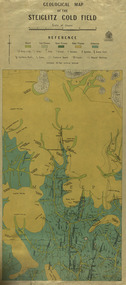
Map, Geological Map of The Stieglitz Gold Field, 1940
... ...township of steiglitz...Published 1940." steiglitz geology geological map north albion moreep mining mine caribald reef durdidwarrah gilbraltar hill mount pleasant gully township of steiglitz W.H. Ferguson Garibaldi Reef Yankee Gully Kinglock Mine Engine Shaft herbert werner frederick de nully Albion Gully Virago Reef Mulrooney's Reef Rectangular geological map edged in masking tape showing Steiglitz, Victoria. ...At the bottom of the 2nd page, there is text that reads "Geologically and topographically surveyed in 1909 by W.H. Ferguson, Assistant Field Geologist. Published 1940."Rectangular geological map edged in masking tape showing Steiglitz, Victoria. Scale 48 chains to 4 inches.steiglitz, geology, geological map, north albion, moreep, mining, mine, caribald reef, durdidwarrah, gilbraltar hill, mount pleasant gully, township of steiglitz, w.h. ferguson, garibaldi reef, yankee gully, kinglock mine engine shaft, herbert werner frederick de nully, albion gully, virago reef, mulrooney's reef -
 Ballan Shire Historical Society
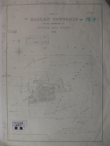
Map - Map. Ballan Township, Plan of Ballan Township in the Counties of Bourke and Grant
... Ballan Shire Historical Society 45-47 Steiglitz St Ballan goldfields The map is an early one of the township of Ballan showing street names and land owners. ...The map is an early one of the township of Ballan showing street names and land owners.The map is significant in that it lists the owners of the house blocks within the township.A map showing the township and surrounding area of Ballan in 1856. Town streets are named as are the owners of the subdivided blocks of land. The map is a lithocopy and there is a scale in chains."D D Fraser" is written across the top of the map and "1856" is written in the near top right corner. There are other additions to the map but they are very difficult to decipher accurately or completely.ballan, ballan township map, ballan1856