Showing 2691 items matching "townships"
-
 Eltham District Historical Society Inc
Booklet - Folder, Shire of Nillumbik, The Townships of Nillumbik, 1996
... The Townships of Nillumbik...townships...Copy of Council brochure "The Townships of Nillumbik" with correspondence from H.G. noting inaccurate information and providing correction. ...This was an early Nillumbik Shire publication endorsed by the Commissioner Kevin Abbott. townships nillumbik 5 pages The Townships of Nillumbik Booklet Folder Shire of Nillumbik Harry Gilham ...Copy of Council brochure "The Townships of Nillumbik" with correspondence from H.G. noting inaccurate information and providing correction. This was an early Nillumbik Shire publication endorsed by the Commissioner Kevin Abbott.5 pagestownships, nillumbik -
 Marysville & District Historical Society
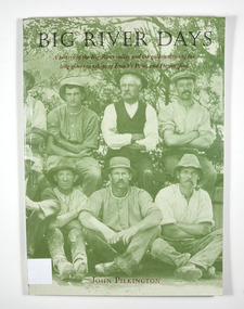
Book, Big River Days-A history of the Big River valley and the golden times of the long gone townships of Enoch's Point and Darlingford, 1996
... Big River Days-A history of the Big River valley and the golden times of the long gone townships of Enoch's Point and Darlingford...A history of the Big River valley and the townships of Enoch's Point and Darlingford, Victoria...Big River Days-A history of the Big River valley and the golden times of the long gone townships of Enoch's Point and Darlingford Book Book John Keith Pilkington Sandra Nobes RossCo Print ...A history of the Big River valley and the townships of Enoch's Point and Darlingford, VictoriaPaperback. Cover has a photograph of a group of men sitting and crouching for a group photograph. There are trees in the background.for Doug - / With best wishes,/ John Pilkington / January 2000 To the memory of my parents,/ Ralph and Florence Pilkington Stamp of the Marysville & District Historical Society Inc / P.O. Box 22 / Marysville 3779enoch point, darlingford, big river, victoria, australia, history, john keith pilkington -
 Tatura Irrigation & Wartime Camps Museum
Archival File, Rodney Shire Townships c 1886
... Rodney Shire Townships c 1886...Tatura Irrigation & Wartime Camps Museum 49 Hogan Street Tatura the-murray Grey archival file containing plastic sleeves with photos of Tatura in the early days. Rodney Shire Townships c 1886 Archival File ...Grey archival file containing plastic sleeves with photos of Tatura in the early days. -
 Marysville & District Historical Society
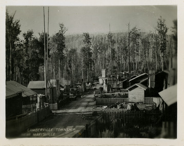
Photograph (item) - Black and white photograph, Unknown
... An early black and white photograph of the township of Cambarville near Marysville in Victoria. ...An early black and white photograph of the township of Cambarville near Marysville in Victoria....CAMBERVILLE TOWNSHIP,/ NEAR MARYSVILLE....An early black and white photograph of the township of Cambarville near Marysville in Victoria. ...An early black and white photograph of the township of Cambarville near Marysville in Victoria. Cambarville is notable for its giant mountain ash (Eucalyptus regnans) trees within the Cumberland Memorial Scenic Reserve, and relics from former sawmills and gold mining. The Big Culvert is located nearby on the Marysville-Woods Point Road, which was historically part of the Yarra Track. Cambarville was established as a timber mill town in the 1940s. Timber mill owners A Cameron and FJ Barton named Cambarville. They established the mill to salvage timber from trees destroyed in the 1939 bushfires. Cambarville was impacted by the 2009 Black Saturday bushfires and any remaining structures were destroyed.An early black and white photograph of the township of Cambarville near Marysville in Victoria.CAMBERVILLE TOWNSHIP,/ NEAR MARYSVILLE.cambarville, marysville, victoria, australia, cameron and barton sawmill, photograph -
 Buninyong & District Historical Society
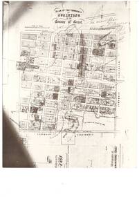
Photograph - Black and white photograph of Plan of the Township of Buninyong, Plan of the Township of Buninyong in the County of Grant March 18 1856
... Plan of the Township of Buninyong in the County of Grant March 18 1856...A photograph of the Plan of the Township of Buninyong from the Surveyor Generals Office Melbourne March 1856...A black and white photograph showing the Plan of the Township of Buninyong..."Plan of the Township of Buninyong County of Grant", Surveyor Generals Office Melbourne 18th March 1856, various handwritten notations...A photograph of the Plan of the Township of Buninyong from the Surveyor Generals Office Melbourne March 1856 The map is one of the earliest of Buninyong and shows some notations indicating some allocations of land that were revoked and possibly the location of tannery dam Buninyong Township Maps "Plan of the Township of Buninyong County of Grant", Surveyor Generals Office Melbourne 18th March 1856, various handwritten notations A black and white photograph showing the Plan of the Township of Buninyong Plan of the Township of Buninyong in the County of Grant March 18 1856 Photograph Black and white photograph of Plan of the Township of Buninyong ...A photograph of the Plan of the Township of Buninyong from the Surveyor Generals Office Melbourne March 1856The map is one of the earliest of Buninyong and shows some notations indicating some allocations of land that were revoked and possibly the location of tannery damA black and white photograph showing the Plan of the Township of Buninyong"Plan of the Township of Buninyong County of Grant", Surveyor Generals Office Melbourne 18th March 1856, various handwritten notationsbuninyong township, maps -
 Emerald Museum & Nobelius Heritage Park
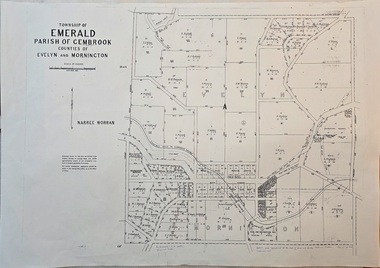
Map - Image of surveyor's map of the Township of Emerald, Surveyors map, Emerald Township 1955, c1955
... Surveyors map, Emerald Township 1955...Emerald township map c1955...Image of surveyor's map - Township of Emerald 1955...Township of Emerald/parish of Gembrook/Counties of Evelyn & Mornington/By Authority W.M.Huston, Government Printer/Drawn and reproduced at the Dept. of Lands and Survey, Melbourne, Victoria, September 1955...Emerald Museum & Nobelius Heritage Park 5 Crichton Rd Emerald yarra-valley-and-the-dandenong-ranges Emerald township map c1955 Township of Emerald/parish of Gembrook/Counties of Evelyn & Mornington/By Authority W.M.Huston, Government Printer/Drawn and reproduced at the Dept. of Lands and Survey, Melbourne, Victoria, September 1955 Image of surveyor's map - Township of Emerald 1955 Surveyors map, Emerald Township 1955 Map Image of surveyor's map of the Township of Emerald ...Emerald township map c1955Image of surveyor's map - Township of Emerald 1955Township of Emerald/parish of Gembrook/Counties of Evelyn & Mornington/By Authority W.M.Huston, Government Printer/Drawn and reproduced at the Dept. of Lands and Survey, Melbourne, Victoria, September 1955 -
 Marysville & District Historical Society
Photograph (item) - Black and white photograph, Original photograph-April 1945
... A copy of a black and white photograph of Cambarville township near Marysville. Cambarville was established as a timber mill town in the 1940s. ...A copy of a black and white photograph of Cambarville township near Marysville....Township of Cambarville established in 1940s by timber mill owners A. ...A copy of a black and white photograph of Cambarville township near Marysville. Cambarville was established as a timber mill town in the 1940s. ...A copy of a black and white photograph of Cambarville township near Marysville. Cambarville was established as a timber mill town in the 1940s. Timber mill owners A. Cameron and F.J. Barton named Cambarville. They established the mill to salvage timber from trees destroyed in the 1939 bushfires. Cambarville was impacted by the 2009 Black Saturday bushfires and any remaining structures were destroyed. The original photograph was taken in April 1945.A copy of a black and white photograph of Cambarville township near Marysville.Township of Cambarville established in 1940s by timber mill owners A. Cameron and F.J. Barton. April 1945marysville, victoria, 1939 bushfires, 2009 black saturday bushfires, cambarville, a. cameron, f.j. barton, photograph, australia -
Clunes Museum
Map - CLUNES MAP SHOWING STREETS AND LOT NUMBERS
... MAPS, PARISH OF CLUNES, CLUNES TOWNSHIP...CLUNES TOWNSHIP AND STREETS...Clunes Museum 36 Fraser Street enter building through Collins Place Clunes goldfields PURCHASED FROM DONOR LOCAL HISTORY DOCUMENT MAPS CLUNES TOWNSHIP CLUNES TOWNSHIP AND STREETS MAPS, PARISH OF CLUNES, CLUNES TOWNSHIP Map CLUNES MAP SHOWING STREETS AND LOT NUMBERS ...PURCHASED FROM DONORMAPS, PARISH OF CLUNES, CLUNES TOWNSHIPCLUNES TOWNSHIP AND STREETSlocal history, document, maps, clunes township -
 Clunes Museum
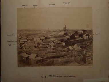
Photograph, 1865
... VIEW IN TOWNSHIP CLUNES, SOUTH EAST. PERIOD 1865. TAKEN FROM HILLSIDE BELOW CAMP PARADE, VICINITY MR. ...PHOTOGRAPH OF TOWNSHIP OF CLUNES, SOUTH EAST .1 SEPIA PHOTOGRAPH MOUNTED ON CARDBOARD. .2 BLACK AND WHITE PRINT .3 SEPIA PHOTO PRINT .4 BLACK AND WHITE PHOTO PRINT .5 BLACK AND WHITE PHOTO PRINT HOUSES SURROUNDED BY PICKET FENCES, POPPET LEGS AND CHIMNEY STACK....VIEW IN TOWNSHIP CLUNES. SOUTH EAST....SWANTON'S HOUSE local history photography photographs clunes township VIEW IN TOWNSHIP CLUNES. SOUTH EAST. ...VIEW IN TOWNSHIP CLUNES, SOUTH EAST. PERIOD 1865. TAKEN FROM HILLSIDE BELOW CAMP PARADE, VICINITY MR. SWANTON'S HOUSE PHOTOGRAPH OF TOWNSHIP OF CLUNES, SOUTH EAST .1 SEPIA PHOTOGRAPH MOUNTED ON CARDBOARD. .2 BLACK AND WHITE PRINT .3 SEPIA PHOTO PRINT .4 BLACK AND WHITE PHOTO PRINT .5 BLACK AND WHITE PHOTO PRINT HOUSES SURROUNDED BY PICKET FENCES, POPPET LEGS AND CHIMNEY STACK.VIEW IN TOWNSHIP CLUNES. SOUTH EAST.local history, photography, photographs, clunes township -
Clunes Museum
Map
... MAP OF CLUNES WATER SUPPLY, TOWNSHIP OF CLUNES, SHOWING SYSTEM OF DISTRIBUTION....TOWNSHIP OF CLUNES...Clunes Museum 36 Fraser Street enter building through Collins Place Clunes goldfields MAP DATED JULY 21ST,1873 local history document maps clunes water TOWNSHIP OF CLUNES MAP OF CLUNES WATER SUPPLY, TOWNSHIP OF CLUNES, SHOWING SYSTEM OF DISTRIBUTION. ...MAP DATED JULY 21ST,1873MAP OF CLUNES WATER SUPPLY, TOWNSHIP OF CLUNES, SHOWING SYSTEM OF DISTRIBUTION.TOWNSHIP OF CLUNESlocal history, document, maps, clunes water -
Lakes Entrance Historical Society
Map - Bullumwaal c1900, 1985
... ...Townships...Based on the first survey of the township map drawn on from memory by Syd Hibbins...Township map shows landowners, roads, Boggy Creek, mines....Lakes Entrance Historical Society 4 Marine Parade Lakes Entrance gippsland Based on the first survey of the township map drawn on from memory by Syd Hibbins Roads and Streets Mines and Mining Townships Waterways landowners Township map shows landowners, roads, Boggy Creek, mines. ...Based on the first survey of the township map drawn on from memory by Syd HibbinsTownship map shows landowners, roads, Boggy Creek, mines.roads and streets, mines and mining, townships, waterways, landowners -
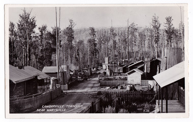 Marysville & District Historical Society
Postcard (item) - Black and white postcard, Valentine Publishing Co. Pty. Ltd, CAMBARVILLE TOWNSHIP, NEAR MARYSVILLE, 1923-1963
... CAMBARVILLE TOWNSHIP, NEAR MARYSVILLE....An early black and white postcard of the township of Cambarville near Marysville in Victoria. ...An early black and white postcard of the township of Cambarville near Marysville in Victoria. ...CAMBARVILLE TOWNSHIP, NEAR MARYSVILLE V.35. VALENTINE'S/ POST CARD A GENUINE PHOTOGRAPH...An early black and white postcard of the township of Cambarville near Marysville in Victoria. ...An early black and white postcard of the township of Cambarville near Marysville in Victoria. Cambarville was established as a timber mill town in the 1940s. Timber mill owners A. Cameron and F.J. Barton named Cambarville. They established the mill to salvage timber from trees destroyed in the 1939 bushfires. Cambarville was impacted by the 2009 Black Saturday bushfires and any remaining structures were destroyed. This postcard was produced by Valentine's Publishing Co as a souvenir of Marysville.An early black and white postcard of the township of Camberville near Marysville in Victoria. CAMBARVILLE TOWNSHIP, NEAR MARYSVILLE V.35. VALENTINE'S/ POST CARD A GENUINE PHOTOGRAPHmarysville, victoria, souvenir, 1939 bushfires, 2009 black saturday bushfires, postcard, valentine's publishing co, a. cameron, f.j. barton -
 Kiewa Valley Historical Society
Photo - Bogong Township, March 1944
... Black and white photograph of Bogong Township taken March 1944...Handwritten on the back of photo - Township March '44...The lake is one of the many water storage reservoirs used to supply the power stations their main power to run the huge turbines generating the final product, electricity Bogong Village SECV Handwritten on the back of photo - Township March '44 Black and white photograph of Bogong Township taken March 1944 Photo - Bogong Township ...In 1940 Field Headquarters for the Kiewa Scheme were established at Bogong with office, workshop facilities and accommodation for workmen, staff and some families constructed. (There had been a 'tent camp' on this site in 1939 but was destroyed by bushfires) Construction of accommodation continued until 1947. A total of 40 houses plus a hostel for single staff, post office, police station, medical centre and primary school all with water and sewerage and electricity supply. The staff hostel was known as Kiewa House and is now occupied by the Education Department. Lake Guy was named after Mr. L.T. Guy who was the Resident Engineer in charge of construction work and associated activities on the Kiewa area. He held this position from 1939 to November 1946 when he was transferred to Head Office. The Bogong Township was developed firstly as an accommodation centre (base camp) for construction workers employed under the Kiewa Hydroelectric Scheme. Due to the influx of European workers into the Township the beautification of the immediate surrounds (gardens etc.) had a distinct European flavour. This environment has been very beneficial for tourism in later years. At the completion of the scheme, in the 1960's, the village was opened to public/tourism use. Strict environmental control has not allowed for any extensive redevelopment in tourist accommodation and basically restricted it to the accommodation initially built for the construction workers. Activities such a bike riding, snow skiing, restricted horse riding and bush walking on the Alpine plains and mountains are now a viable part of the Kiewa Valley Tourist Industry. The lake is one of the many water storage reservoirs used to supply the power stations their main power to run the huge turbines generating the final product, electricityBlack and white photograph of Bogong Township taken March 1944Handwritten on the back of photo - Township March '44bogong village, secv -
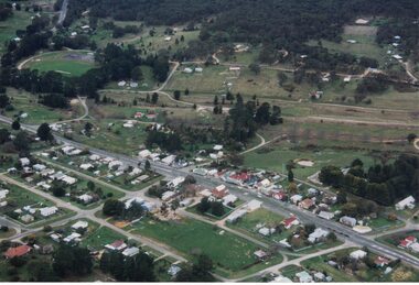 Linton and District Historical Society Inc
Photograph, Photographer: Alan Giles, Aerial View of Linton, 1991, 1.9.1991
... Colour photograph, aerial view of Linton township looking north...."Linton township, Vic-1st September 1991"....Shows oval, left top corner, Sussex St (Glenelg Highway) running from bottom RH corner. Linton township "Linton township, Vic-1st September 1991". ...Photograph taken by Alan Giles whilst on a joy flight over Linton. Shows oval, left top corner, Sussex St (Glenelg Highway) running from bottom RH corner.Colour photograph, aerial view of Linton township looking north."Linton township, Vic-1st September 1991".linton township -
 Sunbury Family History and Heritage Society Inc.
Photograph, Rosa McCall, Old Broadmeadows Township, 1949
... Old Broadmeadows Township......Townships...The former Old Broadmeadows township in the photograph was taken in 1949. ...A print of a non-digital black and white photograph of a small country township with a shop on the RHS and a two storey building in the middle distance. ...The former Old Broadmeadows township in the photograph was taken in 1949. ...The former Old Broadmeadows township in the photograph was taken in 1949. The hotel is the two storey building in the middle distance and the former general store is partly hidden by trees on the RHS. The image is looking to the north in Fawkner Street, across the Moonee Ponds Creek. The township is now part of Westmeadows.Old Broadmeadows Township was an important stopping-off point for travellers on their way to Sydney on the Old Sydney Road, (now Mickleham Road) up until 1869 when Sydney Road was finally opened. A print of a non-digital black and white photograph of a small country township with a shop on the RHS and a two storey building in the middle distance. Pine trees are growing on either side of the roadway.old broadmeadows township, townships, moonee ponds creek, westmeadows -
 Halls Gap & Grampians Historical Society
Map - Photocopy
... Photocopy of map of Heatherlie Township...Township of Heatherlie; Parish of Boroka; County of Borung; scale measurement; R.O. ...Halls Gap & Grampians Historical Society Centennial Hall 117-119 Grampians Road Halls Gap grampians MAPS Heatherlie Township Township of Heatherlie; Parish of Boroka; County of Borung; scale measurement; R.O. ...Photocopy of map of Heatherlie TownshipTownship of Heatherlie; Parish of Boroka; County of Borung; scale measurement; R.O. Robson Authorised Surveyormaps, heatherlie township -
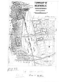
 Halls Gap & Grampians Historical Society
Map - Coloured
... Map showing layout for township of Heatherlie...Township of Heatherlie; Parish of Boroka; County of Borung; scale measurement; R.O. ...Halls Gap & Grampians Historical Society Centennial Hall 117-119 Grampians Road Halls Gap grampians MAPS Heatherlie Township Township of Heatherlie; Parish of Boroka; County of Borung; scale measurement; R.O. ...Map showing layout for township of HeatherlieTownship of Heatherlie; Parish of Boroka; County of Borung; scale measurement; R.O. Robson Authorised surveyormaps, heatherlie township -
 Lakes Entrance Historical Society
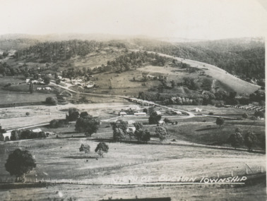
Postcard - Buchan Victoria, 1940 c
... Township...Black and white small postcard of township looking toward the hills beyond Buchan Victoria. ...View of Buchan Township...Lakes Entrance Historical Society 4 Marine Parade Lakes Entrance gippsland Township Transport View of Buchan Township Black and white small postcard of township looking toward the hills beyond Buchan Victoria. ...Black and white small postcard of township looking toward the hills beyond Buchan Victoria. Also two other postcards of Buchan Valley donated by Teena Daley and David PriceView of Buchan Townshiptownship, transport -
 Sunshine and District Historical Society Incorporated
Map - Township of Braybrook Map 11th May 1855, 11th May 1855
... Very early cloth map of the Township of Braybrook Map 11th May 1855 showing allotments in Braybrook & Braybrook North...Township of Braybrook Map 11th May 1855...Braybrook Map Township of Braybrook Map 11th May 1855 Very early cloth map of the Township of Braybrook Map 11th May 1855 showing allotments in Braybrook & Braybrook North Map Township of Braybrook Map 11th May 1855 ...Township of Braybrook Map 11th May 1855braybrook, map -
 Orbost & District Historical Society
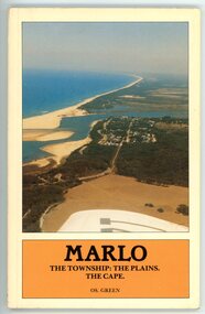
Booklet - MARLO THE TOWNSHIP: THE PLAINS, THE CAPE, Os. Green, 1984
... MARLO THE TOWNSHIP: THE PLAINS, THE CAPE ...Cream booklet with an aerial photo of the Marlo township and area, Snowy River and sea. Black writing in an orange coloured box....MARLO THE TOWNSHIP: THE PLAINS, THE CAPE. OS. GREEN...Black writing in an orange coloured box. MARLO THE TOWNSHIP: THE PLAINS, THE CAPE Booklet MARLO THE TOWNSHIP: THE PLAINS, THE CAPE Os. ...History booklet of the Marlo district written by OS. Green. Contains photos, maps, diagrams. Dated from 1875 to 1983This booklet is significant because it describes the history, in detail, the area around Marlo.Cream booklet with an aerial photo of the Marlo township and area, Snowy River and sea. Black writing in an orange coloured box.MARLO THE TOWNSHIP: THE PLAINS, THE CAPE. OS. GREENmarlo, marlo and district, snowy river, os. green -
Lakes Entrance Historical Society
Map - Gippsland West Metung
... ...Townships...Shows King Lake, Townships Paynesville and Metung...Appears to be copied from a book entitled Sydney to Melbourne Waterways Townships Shows King Lake, Townships Paynesville and Metung Map Gippsland West Metung ...Appears to be copied from a book entitled Sydney to MelbourneShows King Lake, Townships Paynesville and Metungwaterways, townships -
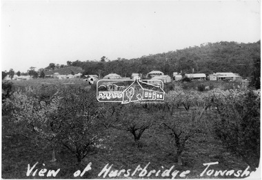 Eltham District Historical Society Inc
Photograph, View of Hurstbridge township
... View of Hurstbridge township...View across an orchard of flowering fruit trees towards the small township of Hurstbridge. Around 1920s....View of Hurstbridge township...It is significant in being the first community sourced collection representing the places and people of the Shire's first one hundred years. sepp shire of eltham pioneers photograph collection hurstbridge orchards View of Hurstbridge township Digital image View of Hurstbridge township Photograph Photograph ...View across an orchard of flowering fruit trees towards the small township of Hurstbridge. Around 1920s.This photo forms part of a collection of photographs gathered by the Shire of Eltham for their centenary project book, "Pioneers and Painters: 100 years of the Shire of Eltham" by Alan Marshall (1971). The collection of over 500 images is held in partnership between Eltham District Historical Society and Yarra Plenty Regional Library (Eltham Library) and is now formally known as 'The Shire of Eltham Pioneers Photograph Collection.' It is significant in being the first community sourced collection representing the places and people of the Shire's first one hundred years.Digital imageView of Hurstbridge townshipsepp, shire of eltham pioneers photograph collection, hurstbridge, orchards -
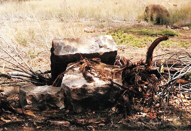 Sunshine and District Historical Society Incorporated
Photograph - Remains of the first Deer Park Township, Des Johnson
... Remains of the first Deer Park Township...Photographs of Square cut blue stone unearthed are the remains of the first Deer Park Township south of Ballarat Road Melways Map 25 H8...Deer Park Photographs of Square cut blue stone unearthed are the remains of the first Deer Park Township south of Ballarat Road Melways Map 25 H8 Remains of the first Deer Park Township Photograph Remains of the first Deer Park Township De Johnson ...Photographs of Square cut blue stone unearthed are the remains of the first Deer Park Township south of Ballarat Road Melways Map 25 H8deer park -
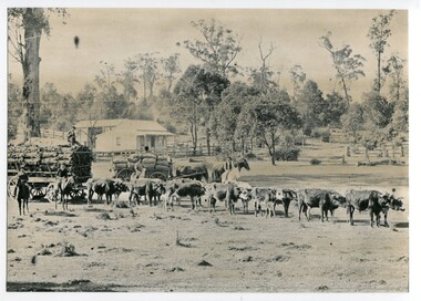 Orbost & District Historical Society
black and white photograph, 1889
... This photograph shows a large bullock team at the foot (eastern side?) of the Orbost township....on back - " At the foot of the township - 1889"...Orbost & District Historical Society Ruskin Street Orbost gippsland This photograph shows a large bullock team at the foot (eastern side?) of the Orbost township. This is a pictorial record of transport used in the late 19th century in Orbost. orbost transport-bullock-teams horse-drawn-transport on back - " At the foot of the township - 1889" A large black / white photograph of a bullock team pulling a laden cart. ...This photograph shows a large bullock team at the foot (eastern side?) of the Orbost township.This is a pictorial record of transport used in the late 19th century in Orbost.A large black / white photograph of a bullock team pulling a laden cart. A man is sitting on top of the freight. In the background is a horse - drawn cart loaded with sacks (maize?) with a man on a horse to the side and another standing on the shafts. In the foreground are two men on horses. There is a small house and barn in the background.on back - " At the foot of the township - 1889"orbost transport-bullock-teams horse-drawn-transport -
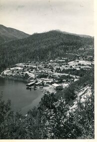
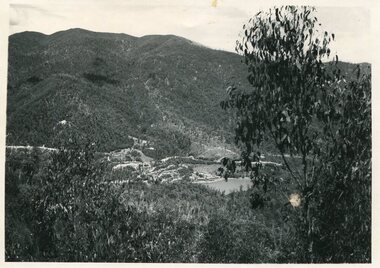
Tatura Irrigation & Wartime Camps Museum
Photograph, Eildon Township, 1957
... Eildon Township...Aerial photograph - looking down on township in middle foreground - overflow dam to the right, middle distance - dam wall with reservoir beyond - mountain tops forming horizon...On frame below photo: "Eildon Township."...Aerial photograph - looking down on township in middle foreground - overflow dam to the right, middle distance - dam wall with reservoir beyond - mountain tops forming horizon Eildon Township Photograph ...Taken by photographer for State Rivers and Water Supply Commission.Medium sized black and white photo. Aerial photograph - looking down on township in middle foreground - overflow dam to the right, middle distance - dam wall with reservoir beyond - mountain tops forming horizonOn frame below photo: "Eildon Township."victoria state rivers and water supply commission, eildon -
Lakes Entrance Historical Society
Map - Princes Highway from Bairnsdale to Lake Tyers, Township of Lakes Entrance
... ...Townships...Shows Princes Highway from Bairnsdale to Lake Tyers, Township of Lakes Entrance...Appears to be copied from a book entitled Sydney to Melbourne Roads and Streets Townships Shows Princes Highway from Bairnsdale to Lake Tyers, Township of Lakes Entrance Map Princes Highway from Bairnsdale to Lake Tyers, Township of Lakes Entrance ...Appears to be copied from a book entitled Sydney to MelbourneShows Princes Highway from Bairnsdale to Lake Tyers, Township of Lakes Entranceroads and streets, townships -
Clunes Museum
Photograph - LITHOGRAPH PRINT
... LITHOGRAPH OF A SCETCH OF PORT PHILIP MINING COMPANY AND THE TOWNSHIP OF CLUNES WITH FRASER STREET IN THE FRONT ORIGINAL PHOTOGRAPH TAKEN FROM THE HILL BEHIND THE OLD LIBRARY IN TEMPLETON STREET ...TOWNSHIP OF CLUNES 1869 HANDSIGNED BY GEOFFREY BLAINEY - 17/3/2001...Clunes Museum 36 Fraser Street enter building through Collins Place Clunes goldfields THIS PHOTOGRAPH WOULD HAVE BEEN TAKEN PRIOR TO THE FIRESWHICH DESTROYED THE ORIGINAL SHOPS IN FRASER STREET CLUNES 1869 PORT PHILIPMINE GEOFFREY BLAINEY LITHOGRAPH OF MINE TOWNSHIP OF CLUNES 1869 HANDSIGNED BY GEOFFREY BLAINEY - 17/3/2001 LITHOGRAPH OF A SCETCH OF PORT PHILIP MINING COMPANY AND THE TOWNSHIP OF CLUNES WITH FRASER STREET IN THE FRONT ORIGINAL PHOTOGRAPH TAKEN FROM THE HILL BEHIND THE OLD LIBRARY IN TEMPLETON STREET Photograph LITHOGRAPH PRINT ...THIS PHOTOGRAPH WOULD HAVE BEEN TAKEN PRIOR TO THE FIRESWHICH DESTROYED THE ORIGINAL SHOPS IN FRASER STREETLITHOGRAPH OF A SCETCH OF PORT PHILIP MINING COMPANY AND THE TOWNSHIP OF CLUNES WITH FRASER STREET IN THE FRONT ORIGINAL PHOTOGRAPH TAKEN FROM THE HILL BEHIND THE OLD LIBRARY IN TEMPLETON STREET TOWNSHIP OF CLUNES 1869 HANDSIGNED BY GEOFFREY BLAINEY - 17/3/2001clunes 1869 port philipmine, geoffrey blainey, lithograph of mine -
 Kiewa Valley Historical Society
Photo - Bogong Township, September 1953
... Black and white photograph of Bogong Township taken from Little Arthur fire track. ...Faded handwritten inscription on back - Bogong Township taken from Little Arthur fire track. ...September 1953 Photo - Bogong Township ...In 1940 Field Headquarters for the Kiewa Scheme were established at Bogong with office, workshop facilities and accommodation for workmen, staff and some families constructed. (There had been a 'tent camp' on this site in 1939 but was destroyed by bushfires) Construction of accommodation continued until 1947. A total of 40 houses plus a hostel for single staff, post office, police station, medical centre and primary school all with water and sewerage and electricity supply. The staff hostel was known as Kiewa House and is now occupied by the Education Department. Lake Guy was named after Mr. L.T. Guy who was the Resident Engineer in charge of construction work and associated activities on the Kiewa area. He held this position from 1939 to November 1946 when he was transferred to Head Office. The Bogong Township was developed firstly as an accommodation centre (base camp) for construction workers employed under the Kiewa Hydroelectric Scheme. Due to the influx of European workers into the Township the beautification of the immediate surrounds (gardens etc.) had a distinct European flavour. This environment has been very beneficial for tourism in later years. At the completion of the scheme, in the 1960's, the village was opened to public/tourism use. Strict environmental control has not allowed for any extensive redevelopment in tourist accommodation and basically restricted it to the accommodation initially built for the construction workers. Activities such a bike riding, snow skiing, restricted horse riding and bush walking on the Alpine plains and mountains are now a viable part of the Kiewa Valley Tourist Industry. The lake is one of the many water storage reservoirs used to supply the power stations their main power to run the huge turbines generating the final product, electricityBlack and white photograph of Bogong Township taken from Little Arthur fire track. September 1953Faded handwritten inscription on back - Bogong Township taken from Little Arthur fire track. Sept 1953bogong village, secv -
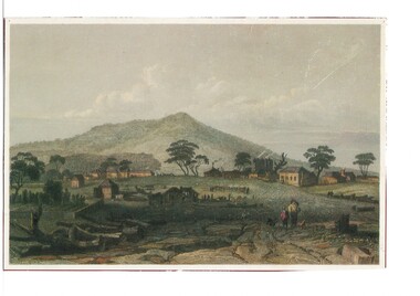 Buninyong & District Historical Society
Artwork, other - Colour reproduction of lithograph "Township of Buninyong" c1852, "Township of Buninyong" c1852
... "Township of Buninyong" c1852...Colour reproduction of lithograph "Township of Buninyong" c1852 from the cover of "Three Times Blest"...Henry Winkles Township of Buninyong c 1852 Lithograph, originally published in Montgomery Martin's "Australia" Reproduced "Three Times Blest"...Buninyong & District Historical Society Old Court House, Buninyong Town Hall 313 Learmonth Street Buninyong goldfields Early image of Buninyong c1852 showing evidence of land clearing, cultivation, residential and farm buildings and Mount Buninyong with tree cover Buninyong was one of the earliest settlements Victoria and became a very important place in the history of the goldrush Early settlement Henry Winkles Mount Buninyong Buninyong Henry Winkles Township of Buninyong c 1852 Lithograph, originally published in Montgomery Martin's "Australia" Reproduced "Three Times Blest" Colour reproduction of lithograph "Township of Buninyong" c1852 from the cover of "Three Times Blest" "Township of Buninyong" c1852 Artwork, other Colour reproduction of lithograph "Township of Buninyong" c1852 ...Early image of Buninyong c1852 showing evidence of land clearing, cultivation, residential and farm buildings and Mount Buninyong with tree coverBuninyong was one of the earliest settlements Victoria and became a very important place in the history of the goldrushColour reproduction of lithograph "Township of Buninyong" c1852 from the cover of "Three Times Blest"Henry Winkles Township of Buninyong c 1852 Lithograph, originally published in Montgomery Martin's "Australia" Reproduced "Three Times Blest"early settlement, henry winkles, mount buninyong, buninyong