Showing 127702 items matching "tracks/roads"
-
 Stawell Historical Society Inc
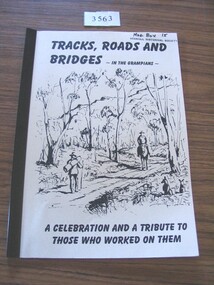
Book, Ida Stanton, Tracks, Roads & Bridges, In the Grampians, 2002
... Tracks, Roads & Bridges, In the Grampians ...A History of the Roads, Tracks and Bridges in the Grampians...TRacks, Roads and Bridges - In the Grampians. ...Stawell Historical Society Inc 46 Longfield St Stawell grampians A History of the Roads, Tracks and Bridges in the Grampians stawell TRacks, Roads and Bridges - In the Grampians. ...A History of the Roads, Tracks and Bridges in the GrampiansCrean paper cover with a line drawing of "Entering the Gap" Circa 1870 by Laurie Evans. Plastic BindingTRacks, Roads and Bridges - In the Grampians. A Celebration and a Tribute to those who worked on them.stawell -
 Melbourne Tram Museum
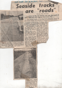
Newspaper, Herald Sun, "Seaside tracks are "roads"", 1955
... "Seaside tracks are "roads""...The article and photo report on the poor condition of roads in particular Hayden's Road and the former, short lived Victorian Railways Beaumaris - Black Rock tram line. ...Newspaper clipping titled - "Seaside tracks are "roads"" - Melbourne Herald 12/11/1955...Trams tramways VR trams track maintenance Tram tracks Beaumaris "Melb "Herald" Sat 12 Nov 1955" Newspaper clipping titled - "Seaside tracks are "roads"" - Melbourne Herald 12/11/1955 "Seaside tracks are "roads"" Newspaper Herald Sun ...The article and photo report on the poor condition of roads in particular Hayden's Road and the former, short lived Victorian Railways Beaumaris - Black Rock tram line. Has two photos showing the road condition. The second photo shows sleepers from the former tram line and a badly worn road surface that had been placed on top. The item by a staff reporter likens the road to wartime battle fields. The tram line rails were lifted or removed during 1939 - see page 35 of The Brighton Electric Line.Yields information about the road condition in the Beaumaris area in 1955.Newspaper clipping titled - "Seaside tracks are "roads"" - Melbourne Herald 12/11/1955"Melb "Herald" Sat 12 Nov 1955"trams, tramways, vr trams, track maintenance, tram tracks, beaumaris -
 Mont De Lancey
Booklet, Department of Main Roads, Toll Roads and Bridges, 1981
... Toll Roads and Bridges......Roads...Early toll roads and bridge use in Australia from early settlement days to 1981....A small slim rectangular paperback brochure with a lithograph of the "New Toll Gate" on Parramatta Road, published in J.G. Austin's Sydney Views. ...Department of Main Roads...There are many photographs inside. Toll Roads and Bridges Booklet Department of Main Roads National Association of Australian State Road Authorities ...A brief history of tolls used throughout history, dating back around 1950 B.C. Early English and USA use is mentioned. Road and bridge tolls in Australia were collected for construction and maintenance of particular roads and bridges similar to their use in England. The clear photographs show the development in the this country up to 1981 when the brochure was published.A small slim rectangular paperback brochure with a lithograph of the "New Toll Gate" on Parramatta Road, published in J.G. Austin's Sydney Views. Green and white edging surrounds the picture with the title Toll Roads and Bridges printed in black lettering at the top right of the cover. On the back is a photograph of Toll cabins at the northern end of the Sydney Harbour Bridge showing automatic and manual toll booths with the symbol for NAASRA and National Association of Australian State Road Authorities printed in black and white at the bottom. Pp. 20. There are many photographs inside.non-fictionA brief history of tolls used throughout history, dating back around 1950 B.C. Early English and USA use is mentioned. Road and bridge tolls in Australia were collected for construction and maintenance of particular roads and bridges similar to their use in England. The clear photographs show the development in the this country up to 1981 when the brochure was published.road tolls, roads, bridges, history of tolls -
 Victorian Railway History Library
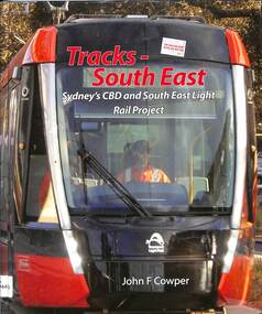
Book, Cowper, John F, Tracks - South East Sydney's CBD and South East Light Rail Project, 2022
... Tracks - South East Sydney's CBD and South East Light Rail Project......Tracks Publishing Pty Ltd...Tracks Publishing Pty Ltd ...'The first and only comprehensive publication to cover the planning and construction of the Sydney South East Light Rail project. The author, John Cowper, spent many days out in the field talking to the workers, management and others to gather as much information as possible. In this publication you'll find the history leading up to the commencement, the planning, construction and commissioning of the project. As well, there is a list of the participating companies and consortia that made the completion of the project possible. The book also includes hundreds of photographs, maps and diagrams covering all aspects of the project.' --back blurb. The first and only comprehensive publication to cover the planning and construction of the Sydney South East Light Rail project. The author, John Cowper, spent many days out in the field talking to the workers, management and others to gather as much information as possible. In this publication you'll find the history leading up to the commencement, the planning, construction and commissioning of the project. As well, there is a list of the participating companies and consortia that made the completion of the project possible. The book also includes hundreds of photographs, maps and diagrams covering all aspects of the project. -- Back cover.index, ill, maps, p.263.non-fiction'The first and only comprehensive publication to cover the planning and construction of the Sydney South East Light Rail project. The author, John Cowper, spent many days out in the field talking to the workers, management and others to gather as much information as possible. In this publication you'll find the history leading up to the commencement, the planning, construction and commissioning of the project. As well, there is a list of the participating companies and consortia that made the completion of the project possible. The book also includes hundreds of photographs, maps and diagrams covering all aspects of the project.' --back blurb. The first and only comprehensive publication to cover the planning and construction of the Sydney South East Light Rail project. The author, John Cowper, spent many days out in the field talking to the workers, management and others to gather as much information as possible. In this publication you'll find the history leading up to the commencement, the planning, construction and commissioning of the project. As well, there is a list of the participating companies and consortia that made the completion of the project possible. The book also includes hundreds of photographs, maps and diagrams covering all aspects of the project. -- Back cover. street-railroads -- design and construction, electric trams - sydney -
 Marysville & District Historical Society
Document (item) - Report, Clement Wilks, Track to the River Jordan Gold Fields, 1864-1865
... Track to the River Jordan Gold Fields...A report by Mr Road Engineer Wilks on the construction of the Yarra Track in Victoria....A report by Mr Road Engineer Wilks on the construction of the Yarra Track in Victoria.......Department of Roads & Bridges...A report by Mr Road Engineer Wilks on the construction of the Yarra Track in Victoria. ...A report by Mr Road Engineer Wilks on the construction of the Yarra Track in Victoria.A report by Mr Road Engineer Wilks on the construction of the Yarra Track in Victoria. The Yarra Track is the former name of the gold fields road from Healesville to the Woods Point and Jordan Goldfields, in Victoria, Australia. By Authority: JOHN FERRES, Government Printer, Melbourneclement wilks, yarra track, marysville, victoria, wood's point, healesville, jordan gold fields -
 Emerald Museum & Nobelius Heritage Park
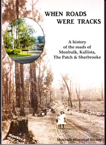
Book - History Book, Jill A'Vard et al, When Roads Were Tracks: A History of the Roads of Monbulk, Kallista, The Patch & Sherbrooke, 2019
... When Roads Were Tracks: A History of the Roads of Monbulk, Kallista, The Patch & Sherbrooke...It is a history of the roads of Monbulk, Kallista, The Patch and Sherbrooke and of the people and communities who lived there and focuses mainly on the period between 1890s and 1930s....Mainly black and white photography. When Roads Were Tracks: A History of the Roads of Monbulk, Kallista, The Patch & Sherbrooke Book History Book Jill A'Vard Armin Richter Monbulk Historical Society ...This is a historical book published by the Monbulk Historical Society with text by Armin Richter and Jill A'Vard. 2019. It is a history of the roads of Monbulk, Kallista, The Patch and Sherbrooke and of the people and communities who lived there and focuses mainly on the period between 1890s and 1930s.This book is a historical reference book pertaining to neighboring towns whose history overlaps that of Emerald.Soft cover book with 248 pages. Mainly black and white photography. jill a'vard, armin richter, monbulk historical society, 2019, monbulk, the patch, kallista, sherbrooke -
 Melbourne Tram Museum
Manual, Yarra Trams, "Glen Huntly Depot Renewal", "Kew Depot - Pit Deepening Roads 1 to 4", "Camberwell Depot Yard Tracks Renewal", 2007 to 2011
... "Glen Huntly Depot Renewal", "Kew Depot - Pit Deepening Roads 1 to 4", "Camberwell Depot Yard Tracks Renewal"...Has a table of contents. .2 - 7 A4 pages - stapled - "Operations Plan - "Kew Depot - Pit Deepening Roads 1 to 4" = Monday 23 June 2008 to Friday 18 July 2008" - has a table of contents, covers maintenance, tram requirements, out stabling, security, sanding and hours of operation. .3 - 19 A4 pages - stapled - "Camberwell Depot Yard Tracks Renewal" - Saturday 3 December 2011 to Monday 12 December 2011 - has a table of contents, service changes, car parking, stabling, maintenance, operations, sanding, cleaning, rosters and test trams and notice to employees. .4 - 3 A4 foolscap sheets - Co-ordinating plan for Kew Depot / Barkers Road entrance and High Street and Cotham Road - dated 25/11/2005 - list works, location, overhead, cabling, track and other works and isolation requirements. ..."Glen Huntly Depot Renewal", "Kew Depot - Pit Deepening Roads 1 to 4", "Camberwell Depot Yard Tracks Renewal" Manual Yarra Trams Hugh Waldron ...Set of three Reports or Operations Plan or Manual for work at Kew and Glen Huntly Depots. .1 - 12 A4 pages - stapled - "Kew Officers Information Manual - Glen Huntly Depot renewal" - Friday 11 May 2007 to Monday 21st May 2007". Has a photo of the depot on the front sheet. Covers service changes, arrangements for changes to services running from Kew Depot, car parking, tram requirements. Has a table of contents. .2 - 7 A4 pages - stapled - "Operations Plan - "Kew Depot - Pit Deepening Roads 1 to 4" = Monday 23 June 2008 to Friday 18 July 2008" - has a table of contents, covers maintenance, tram requirements, out stabling, security, sanding and hours of operation. .3 - 19 A4 pages - stapled - "Camberwell Depot Yard Tracks Renewal" - Saturday 3 December 2011 to Monday 12 December 2011 - has a table of contents, service changes, car parking, stabling, maintenance, operations, sanding, cleaning, rosters and test trams and notice to employees. .4 - 3 A4 foolscap sheets - Co-ordinating plan for Kew Depot / Barkers Road entrance and High Street and Cotham Road - dated 25/11/2005 - list works, location, overhead, cabling, track and other works and isolation requirements. On the rear has a list of the trams for the depot, Collins St, Simpson St and Camberwell. .5 - Notes on the Kew Depot relay by Hugh Waldron received in an email dated 9/3/2018 - from Kew Depot History..1 - Has "H. Waldron" in top left hand corner in blue ink. .2 - ditto "Hugh" in red ink.trams, tramways, yarra trams, kew depot, glenhuntly tram depot, trackwork, depot fan, tram services -
 Greensborough Historical Society
Newsletter, Vic Roads, Vic Roads , Greensborough Bypass Upgrade - Duplication of Plenty River Bridge, August 2005
... Vic Roads , Greensborough Bypass Upgrade - Duplication of Plenty River Bridge...Vic Roads Newsletter regarding the Greensborough Bypass Upgrade and duplication of the Plenty River Bridge....Vic Roads...Greensborough Historical Society 34A Glenauburn Road Lower Plenty Lower Plenty melbourne Vic Roads Newsletter regarding the Greensborough Bypass Upgrade and duplication of the Plenty River Bridge. greensborough bypass vicroads plenty ri plenty river bridge 2 page Newsletter with print and black & white photos Vic Roads , Greensborough Bypass Upgrade - Duplication of Plenty River Bridge Newsletter Newsletter Vic Roads ...Vic Roads Newsletter regarding the Greensborough Bypass Upgrade and duplication of the Plenty River Bridge.2 page Newsletter with print and black & white photosgreensborough bypass, vicroads, plenty ri, plenty river bridge -
Alexandra Timber Tramway & Museum
Mr Sapsford, rubicon channel and tram tracks
... rubicon channel and tram tracks...rubicon photo of channel and tram tracks, put in to feed hydro system .note tree harvest and elevated channel to the right taken by mr sapsford of alexandra...rubicon channel and tram tracks...Alexandra Timber Tramway & Museum 17 Station Street Alexandra high-country Photograph of local event .Building of Rubicon power house ( station ) Detail of construction evedent in photo Un replaceable .record of local events rubicon channel and tram tracks rubicon photo of channel and tram tracks, put in to feed hydro system .note tree harvest and elevated channel to the right taken by mr sapsford of alexandra rubicon channel and tram tracks Mr Sapsford ...Photograph of local event .Building of Rubicon power house ( station ) Detail of construction evedent in photoUn replaceable .record of local eventsrubicon photo of channel and tram tracks, put in to feed hydro system .note tree harvest and elevated channel to the right taken by mr sapsford of alexandrarubicon channel and tram tracks -
 Surrey Hills Historical Society Collection
Photograph, Stand-pipe at the corner of Warrigal and Riversdale Roads, Surrey Hills, c1916, c1916
... Stand-pipe at the corner of Warrigal and Riversdale Roads, Surrey Hills, c1916...The original print had a text which was included in our copy print as follows: "EVEN IN 1916, WATER SUPPLIES FOR MANY SURREY HILLS FARMERS AND MARKET GARDENS STILL / CAME FROM THE STAND-PIPE AT THE WARRIGAL ROAD TRAM TERMINUS. PREVIOUSLY WATER WAS / PURCHASED FROM THE VILLAGE TANK AT THE CORNER OF WINDSOR CRESCENT AND UNION ROAD. / THE PRICE WAS 1/- FOR 400 GALLONS."...In the background is a building that may be a shop with wagons outside and further down the road is a tram....Corner of Warrigal and Riversdale Roads, Surrey Hills, Victoria...In the background is a building that may be a shop with wagons outside and further down the road is a tram. Stand-pipe at the corner of Warrigal and Riversdale Roads, Surrey Hills, c1916 Photograph Photograph ...This was part of an exhibition mounted by the Surrey Hills State Savings Bank in 1976. The original print had a text which was included in our copy print as follows: "EVEN IN 1916, WATER SUPPLIES FOR MANY SURREY HILLS FARMERS AND MARKET GARDENS STILL / CAME FROM THE STAND-PIPE AT THE WARRIGAL ROAD TRAM TERMINUS. PREVIOUSLY WATER WAS / PURCHASED FROM THE VILLAGE TANK AT THE CORNER OF WINDSOR CRESCENT AND UNION ROAD. / THE PRICE WAS 1/- FOR 400 GALLONS."Black and white photo of a horse and water cart in position at the stand-pipe. A man holds the horse's reins and 2 young boys are perched on the cart. In the background is a building that may be a shop with wagons outside and further down the road is a tram.horse-drawn vehicles, water supply, warrigal road, riversdale road, transport, surrey hills, standpipe -
 Eltham District Historical Society Inc
Book, Roads Corporation, Vic Roads 2000: results of intial community consultation, outer Melbourne rural fringe, August 1989
... Vic Roads 2000: results of intial community consultation, outer Melbourne rural fringe...Roads...Roads Corporation...Vic Roads 2000: results of intial community consultation, outer Melbourne rural fringe Book Roads Corporation ...This report presents a summary of the issues and needs communicated by community and road user groups, local government, industry and government department representatives, at two of a series of VICROADS Regional Workshops convened by the Roads Corporation, as the Vic Roads 2000 Victoria's Rural Arterial Strategy is developed. Includes three parts: Outer Metropolitan Regional Workshop Report, Outer Dandenong Regional Workshop Report and background paper - Outer Melbourne rural fringe regional economy and road travel demand.100p.non-fictionThis report presents a summary of the issues and needs communicated by community and road user groups, local government, industry and government department representatives, at two of a series of VICROADS Regional Workshops convened by the Roads Corporation, as the Vic Roads 2000 Victoria's Rural Arterial Strategy is developed. Includes three parts: Outer Metropolitan Regional Workshop Report, Outer Dandenong Regional Workshop Report and background paper - Outer Melbourne rural fringe regional economy and road travel demand.roads, vicroads -
Ringwood and District Historical Society
Plans - Freeway, Country Roads Board, Victoria, Eastern Freeway Ringwood Section - Planning Report on Suggested Concepts Investigation (Country Roads Board) 1974, 1974
... Eastern Freeway Ringwood Section - Planning Report on Suggested Concepts Investigation (Country Roads Board) 1974...Country Roads Board, Victoria...Eastern Freeway Ringwood Section - Planning Report on Suggested Concepts Investigation (Country Roads Board) 1974 Plans - Freeway Country Roads Board, Victoria ...Report on suggested concepts investigation for freeway.Report on suggested concepts investigation for freeway. Buff coloured covers with brown printing. Bound with brown Spirex. pp. 39. -
 Marysville & District Historical Society
Map (Item) - Bush tracks map, John Siseman et al, MARYSVILLE BUSH TRACKS, 1987
... MARYSVILLE BUSH TRACKS...A fold out map of the bush tracks in and around Marysville with information regarding each track. ...A fold out map of the bush tracks in and around Marysville with information regarding each track....A fold out map of the bush tracks in and around Marysville with information regarding each track. marysville victoria australia map bush tracks pindari publications algona publications john siseman gleen van der knijff lady talbot forest drive beauty spot walk michaeldene track steavenson falls tree fern gully walk trestle track phantom falls marysville town walk marysville lookouts round walk keppel falls the beeches round walk cumberland scenic reserve cambarville lake mountain lake mountain walking track A fold out map of the bush tracks in and around Marysville with information regarding each track. ...A fold out map of the bush tracks in and around Marysville with information regarding each track. This map was published by Pindari Publications and distributed by Algona Publications. The track notes were compiled by John Siseman in 1987. The map was drawn by Glenn van der Knijff.A fold out map of the bush tracks in and around Marysville with information regarding each track.marysville, victoria, australia, map, bush tracks, pindari publications, algona publications, john siseman, gleen van der knijff, lady talbot forest drive, beauty spot walk, michaeldene track, steavenson falls, tree fern gully walk, trestle track, phantom falls, marysville town walk, marysville lookouts round walk, keppel falls, the beeches round walk, cumberland scenic reserve, cambarville, lake mountain, lake mountain walking track -
Federation University Historical Collection
Map, Map of Vitilevu showing vehicular roads, native tracks, villages, provinces, 1935
... Map of Vitilevu showing vehicular roads, native tracks, villages, provinces...map vitilevu singatoka nandi Printed map on paper backed onto linen with small inset maps of Nandi and Singatoka Map of Vitilevu showing vehicular roads, native tracks, villages, provinces Map Map ...Printed map on paper backed onto linen with small inset maps of Nandi and Singatoka map, vitilevu, singatoka, nandi -
 Ballarat Tramway Museum
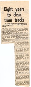
Newspaper, The Courier Ballarat, "Eight years to clear tram tracks", 22/09/1971
... "Eight years to clear tram tracks"... Titled "Eight years to clear tram tracks", about the time planned to remove tram tracks in Ballarat by the CRB on their roads. ...Newspaper cutting from The Courier, about 22/9/1971, about the removal of track in Ballarat and Bendigo. ...Ballarat Tramway Museum South Gardens Reserve Wendouree Parade Ballarat Ballarat goldfields Titled "Eight years to clear tram tracks", about the time planned to remove tram tracks in Ballarat by the CRB on their roads. ...Titled "Eight years to clear tram tracks", about the time planned to remove tram tracks in Ballarat by the CRB on their roads. Notes agreement with the SEC, mentions the Minister for Fuel and Power Mr. Balfour, cost $1.25million, quotes Mr. Oppy of the CRB. Notes that work on the removal of tracks in Sturt St had commenced this week. The second cutting includes a photo of a Mr G Hettich saw cutting the road surface - note the use of the term "instruments" in the caption.Yields information about the starting of track removal in Sturt St Ballarat and later on in other parts of the system, following closure of the SEC operated system.Newspaper cutting from The Courier, about 22/9/1971, about the removal of track in Ballarat and Bendigo. Has the newspaper source on the top edge in ink.crb, sturt st, closure, dismantling, track removal -
 Marysville & District Historical Society
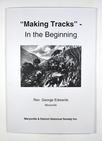
Book, Making Tracks - In the Beginning, 2013
... Making Tracks - In the Beginning...A history of the Yarra Track taken from the notes of the Reverend George Edwards...Photograph on front cover: On the Wood's Point Track early days. Photograph on back cover: Wood's Point Track....Photograph on front cover: On the Wood's Point Track early days. Photograph on back cover: Wood's Point Track. ...A history of the Yarra Track taken from the notes of the Reverend George EdwardsPaperback. Photograph on front cover: On the Wood's Point Track early days. Photograph on back cover: Wood's Point Track.Stamp of the Marysville & District Historical Society Inc / P.O. Box 22 / Marysville 3779 Stamp saying-Limited Edition / No. 029 / of 200 copiesyarra track, wood's point -
 Marysville & District Historical Society
Book, Making Tracks - In the Beginning, 2013
... Making Tracks - In the Beginning...A history of the Yarra Track taken from the notes of the Reverend George Edwards...Photograph on front cover: On the Wood's Point Track early days. Photograph on back cover: Wood's Point Track....Photograph on front cover: On the Wood's Point Track early days. Photograph on back cover: Wood's Point Track. ...A history of the Yarra Track taken from the notes of the Reverend George EdwardsPaperback. Photograph on front cover: On the Wood's Point Track early days. Photograph on back cover: Wood's Point Track.Stamp of the Marysville & District Historical Society Inc / P.O. Box 22 / Marysville 3779 Stamp saying-Limited Edition / No. 072 / of 200 copiesyarra track, wood's point -
 Marysville & District Historical Society
Book, Making Tracks - In the Beginning, 2013
... Making Tracks - In the Beginning...A history of the Yarra Track taken from the notes of the Reverend George Edwards...Photograph on front cover: On the Wood's Point Track early days. Photograph on back cover: Wood's Point Track....Photograph on front cover: On the Wood's Point Track early days. Photograph on back cover: Wood's Point Track. ...A history of the Yarra Track taken from the notes of the Reverend George EdwardsPaperback. Photograph on front cover: On the Wood's Point Track early days. Photograph on back cover: Wood's Point Track.Stamp of the Marysville & District Historical Society Inc / P.O. Box 22 / Marysville 3779 Stamp saying-Limited Edition / No. 073 / of 200 copiesyarra track, wood's point -
 Whitehorse Historical Society Inc.
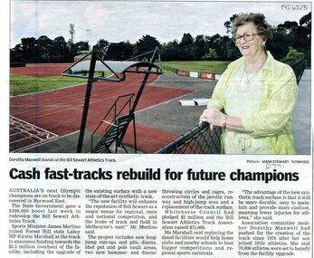
Article, Cash fast-tracks rebuild for future champions, 2010
... Cash fast-tracks rebuild for future champions...A further $2.3 million overhaul for the track will make a state-of-the-art facility....The Victorian State Government recently gave $300,000 for the upgrade of the Bill Sewart Athletic Track. A further $2.3 million overhaul for the track will make a state-of-the-art facility....Whitehorse Historical Society Inc. 2-10 Deep Creek Road Mitcham melbourne A further $2.3 million overhaul for the track will make a state-of-the-art facility. ...The Victorian State Government recently gave $300,000 for the upgrade of the Bill Sewart Athletic Track.The Victorian State Government recently gave $300,000 for the upgrade of the Bill Sewart Athletic Track. A further $2.3 million overhaul for the track will make a state-of-the-art facility.The Victorian State Government recently gave $300,000 for the upgrade of the Bill Sewart Athletic Track.maxwell, dorothy, bill sewart athletic track, marshall, kirstie, merlino, james -
 Surrey Hills Historical Society Collection
Photograph, Lloyd brothers’ horses near corner of Elgar & Whitehorse Roads, c1930
... Lloyd brothers’ horses near corner of Elgar & Whitehorse Roads, c1930...Lloyd Brothers butchers were located on the NW corner Whitehorse Road and Elgar Roads; previously the premises of Edward Tacey, butcher, established in 1888. ...Corner of Elgar & Whitehorse Roads, Surrey Hills, Victoria, Australia...Surrey Hills Historical Society Collection 190A Canterbury Road Canterbury melbourne Lloyd Brothers butchers were located on the NW corner Whitehorse Road and Elgar Roads; previously the premises of Edward Tacey, butcher, established in 1888. ...Lloyd Brothers butchers were located on the NW corner Whitehorse Road and Elgar Roads; previously the premises of Edward Tacey, butcher, established in 1888. There was an abattoir adjoining the premises. In 1901 the Box Hill Reporter contained a protest regarding the proposed extension of the abattoir. In 1907 it was claimed that the development of land in Mont Albert was hindered by the smells and operations of the abattoir. Lloyds also had a shop in Union Road Surrey Hills from 1920-1951, opposite the end of Windsor Crescent.A black and white photograph of a lady squatting in a paddock with two horses.lloyd brothers, butchers, tafe college, elgar road, whitehorse road, mont albert, box hill -
 Whitehorse Historical Society Inc.
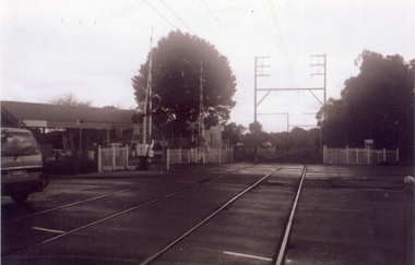
Photograph, Railway tracks looking west, 1/06/2009
... Railway tracks looking west....One of a collection of photographs taken of the Nunawading Railway Station prior to the lowering of the railway line and building of the new railway station on the western side of Springvale Road so that the Springvale Road Rail Crossing can be eliminated....Black & white photograph of he precinct surrounding the Nunawading Station and the Springvale Road Railway crossing. This photograph is the railway crossing and tracks looking west to Blackburn. ...Black & white photograph of he precinct surrounding the Nunawading Station and the Springvale Road Railway crossing. This photograph is the railway crossing and tracks looking west to Blackburn. ...One of a collection of photographs taken of the Nunawading Railway Station prior to the lowering of the railway line and building of the new railway station on the western side of Springvale Road so that the Springvale Road Rail Crossing can be eliminated.Black & white photograph of he precinct surrounding the Nunawading Station and the Springvale Road Railway crossing. This photograph is the railway crossing and tracks looking west to Blackburn. See NP 3545 to NP3567 for the complete set of photographsnunawading railway station, springvale road nunawading, redevelopment of railway line/springvale road. -
 Ballarat Tramway Museum
Drawing - Ballarat Tramways, State Electricity Commission of Victoria - Electricity Supply Department, Showing Double and Single Tracks with Loop Types and Locations, 22/08/1949
... Showing Double and Single Tracks with Loop Types and Locations....Produced by the SEC to document the Ballarat Tramway Routes showing Double and Single Tracks with Loop Types and Locations....SEC document; "Showing Double and Single Tracks with Loop Types and Locations.". Drawn 22/08/1949. ...Produced by the SEC to document the Ballarat Tramway Routes showing Double and Single Tracks with Loop Types and Locations. Drawing showing the individual tram tracks of the Ballarat system as constructed in 1949. ...Produced by the SEC to document the Ballarat Tramway Routes showing Double and Single Tracks with Loop Types and Locations.Drawing showing the individual tram tracks of the Ballarat system as constructed in 1949. SEC document; "Showing Double and Single Tracks with Loop Types and Locations.". Drawn 22/08/1949. Original paper drawing on tracing paper. Original drawing on tracing paper.provincial tramways, state electricity commission of victoria, map, ballarat, ballarat tramways, tram tracks -
 Australian National Surfing Museum
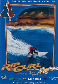
Programme, 2000 Rip Curl Pro / Sunsmart Classic at Bells Beach official contest guide, 01/03/2000
... The cover includes the official event title plus sponsors logos, Rip Curl, Sunsmart, Coca-Cola, Tracks surfing magazine, Surfing Victoria, Surf Coast Tourism, Association of Surfing Professionals and Offshore Music....Tracks Magazine...Australian National Surfing Museum 77 Beach Road Surf City Plaza Surfcoast Highway Torquay great-ocean-road This magazine is representative of event guides prepared for the Rip Curl Pro at Bells Beach each year. ...This magazine is representative of event guides prepared for the Rip Curl Pro at Bells Beach each year. This particular event guide features unique artwork by Indigenous artist/surfer Glenn Romanis including an indigenous representation of the world famous Bells Beach 'bell' on the top left hand corner.The 2000 Rip Curl; Pro event guide featured unique artwork by Indigenous artist Glenn Romanis. During this period the event was one of the first major sporting events in Australia to embrace Aboriginal culture.Full colour 32 page magazine with information about the 2000 Rip Curl Pro / Sunsmart Classic at Bells Beach. The cover features artwork by Indigenous artists Glenn Romanis. The artwork features an indigenous theme relating to Bells Beach.The cover includes the official event title plus sponsors logos, Rip Curl, Sunsmart, Coca-Cola, Tracks surfing magazine, Surfing Victoria, Surf Coast Tourism, Association of Surfing Professionals and Offshore Music.cheyne horan, bells beach, layne beachley, kelly slater, rip curl pro, sunsmart classic, glenn romanis, offshore music festival, terry richardson, nicky wood, mark occhilupo, tom curren, shane dorian, surfers appreciating the natural environment -
 Ballarat Tramway Museum
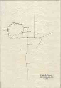
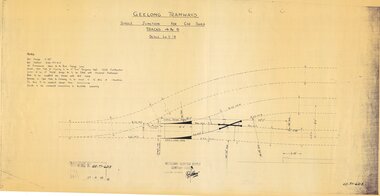
Drawing - GE-T1-6213, Melbourne Electric Supply Co. (MESCo), Single junction for Car Shed tracks 4 & 5, 27/09/2023
... Single junction for Car Shed tracks 4 & 5....Produced by the Geelong Tramways (Geelong Branch of Melbourne Electricity Supply Company Limited) to document the trackwork for Car Shed tracks 4 & 5....Geelong Tramways drawing no GE-T1-6213, "Single junction for Car Shed tracks 4 & 5.". Drawn 27/09/1923. Beige paper copy of original dyeline print. ...Produced by the Geelong Tramways (Geelong Branch of Melbourne Electricity Supply Company Limited) to document the trackwork for Car Shed tracks 4 & 5. Yields information regarding the construction details for the trackwork for a single junction for Car Shed tracks 4 & 5. ...Produced by the Geelong Tramways (Geelong Branch of Melbourne Electricity Supply Company Limited) to document the trackwork for Car Shed tracks 4 & 5.Yields information regarding the construction details for the trackwork for a single junction for Car Shed tracks 4 & 5.Geelong Tramways drawing no GE-T1-6213, "Single junction for Car Shed tracks 4 & 5.". Drawn 27/09/1923. Beige paper copy of original dyeline print. Copy of original. provincial tramways, geelong tramway, melbourne electric supply co. ltd. -
 Melbourne Tram Museum
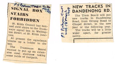
Newspaper, Prahran Times, "Signal box Stairs Forbidden', "New tracks in Dandenong Road", Mar. 1959
... "Signal box Stairs Forbidden', "New tracks in Dandenong Road"...Set of two newspaper clippings from the Prahran Times; .1 - "Signal box Stairs Forbidden', 24/3/1959 - St Kilda Council refusing to give permission for stairs to replace the ladder at St Kilda Junction. .2 - "New tracks in Dandenong Road" - 18/3/1959 about the reconstruction of track between Orrong Road and Chapel St...."Signal box Stairs Forbidden', "New tracks in Dandenong Road" Newspaper Prahran Times ...Set of two newspaper clippings from the Prahran Times; .1 - "Signal box Stairs Forbidden', 24/3/1959 - St Kilda Council refusing to give permission for stairs to replace the ladder at St Kilda Junction. .2 - "New tracks in Dandenong Road" - 18/3/1959 about the reconstruction of track between Orrong Road and Chapel St.On the right hand side of the cutting, gives the newspaper and date and "Also 518 to Seattle" in ink.trams, tramways, mmtb, trackwork, st kilda junction, signals, dandenong road -
 City of Kingston
Photograph - Digital image, Black and white, Roads - Junction of Nepean Highway and South Road, c. 1950
... Roads - Junction of Nepean Highway and South Road...Shops in centre demolished for road widening in 1980's...Black and white image of Nepean Highway and South Road junction point of view from Kingston Town Hall...Printed in black text a round white sticker: 234 Handwritten in red ink 80% Yellow post it note written in blue ink: CHAP 7 234 / - Nepean Hwy + South Road...City of Kingston Parkdale Library 96 Parkers Road, Parkdale Parkdale Junction of Nepean Highway and South Road, Moorabbin - Moorabbin Hotel on right. ...Junction of Nepean Highway and South Road, Moorabbin - Moorabbin Hotel on right. Shops in centre demolished for road widening in 1980'sBlack and white image of Nepean Highway and South Road junction point of view from Kingston Town HallPrinted in black text a round white sticker: 234 Handwritten in red ink 80% Yellow post it note written in blue ink: CHAP 7 234 / - Nepean Hwy + South Roadnepean highway, south road, moorabbin, moorabbin hotel -
 Ballarat Tramway Museum
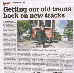
Newspaper, The Courier Ballarat, "Getting our old tram tracks back on new tracks", 13/09/2018 12:00:00 AM
... "Getting our old tram tracks back on new tracks"...Newspaper clipping from The Courier, 13/9/2018, titled "Getting our old tram tracks back on new tracks", about the deteriorating tram track in Wendouree Parade and the Museum seeking "Pick My Project" funding. ..."Getting our old tram tracks back on new tracks" Newspaper The Courier Ballarat ...Newspaper clipping from The Courier, 13/9/2018, titled "Getting our old tram tracks back on new tracks", about the deteriorating tram track in Wendouree Parade and the Museum seeking "Pick My Project" funding. Quotes Neville Britton, Operations Manager. Article written by Rochelle Kirkham, Photo Kate Healy. Gives details of the funding link. Has a photo of Neville pointing to a rail with tram 28 in the background. See Reg Item 7122 re the project outcome and 7123 for the award itself.btm, track repairs, wendouree parade, pick my project -
 Orbost & District Historical Society
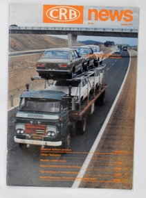
magazine, CRB News, August 1975
... It was succeeded by the Road Construction authority on 1 July 1983 and later merged with the Road Traffic Authority on July 1 1989 to form the Roads Corporation. ...A 19 pp magazine, titled CRB ( Country Roads Board) News. It is dated August 1976. ...Country Roads Board...It was succeeded by the Road Construction authority on 1 July 1983 and later merged with the Road Traffic Authority on July 1 1989 to form the Roads Corporation. ...The Country Roads Board was the government authority for the construction and maintenance of main roads in Victoria between 1913 and 1983. It was succeeded by the Road Construction authority on 1 July 1983 and later merged with the Road Traffic Authority on July 1 1989 to form the Roads Corporation. James Cameron, an Orbost farming pioneer and Member of the Legislative Assembly, fathered the Country Roads Board.This item is a useful research source on the Princes Highway, Gippsland.A 19 pp magazine, titled CRB ( Country Roads Board) News. It is dated August 1976. On the front cover is a coloured photograph of a truck carrying cars. In the background is a road bridge. It contains an article on the Princes Highway, Gippsland.magazine journal-crb-news princes-highway -
 Orbost & District Historical Society
magazine, CRB News, August 1976
... At this time the use of the motor car accentuated the demands for better roads. As a result of these needs the Country Roads Act 1912 was proclaimed in 1913 providing for the establishment of the Country Roads Board as a central road authority with responsibility for those roads within the State considered to be main roads. the C.R.B. was responsible for the construction of roads and bridges including the Snowy River road bridges in Orbost. ...On the front cover the title is in orange print with No. 33 August 1976 above a coloured photo of a truck carrying two tiers of new vehicles along a main sealed road. It contains information and photos of the construction of the Snowy River road bridges....Country Roads Board...At this time the use of the motor car accentuated the demands for better roads. As a result of these needs the Country Roads Act 1912 was proclaimed in 1913 providing for the establishment of the Country Roads Board as a central road authority with responsibility for those roads within the State considered to be main roads. the C.R.B. was responsible for the construction of roads and bridges including the Snowy River road bridges in Orbost. ...By 1910 it had become apparent that there was a need for a central roads authority to take over responsibility from the Board of Lands and Works for the care and management of the main roads of the state of Victoria. Because there was no consistent and systematic policy for road maintenance Victorian roads were in a deplorable condition. At this time the use of the motor car accentuated the demands for better roads. As a result of these needs the Country Roads Act 1912 was proclaimed in 1913 providing for the establishment of the Country Roads Board as a central road authority with responsibility for those roads within the State considered to be main roads. the C.R.B. was responsible for the construction of roads and bridges including the Snowy River road bridges in Orbost. This was a major project involving not only a new bridge over the Snowy River (including Lochiel Lagoon), but other bridges over Ashby’s Gulch and Watt’s Gulch. These new bridges were opened in November 1976 with the unveiling of a plaque on the eastern end of the $2.4M Snowy River Bridge. (ref. May Leatch) This is a useful reference tool on the history of the construction of the Snowy River road bridges.A journal, titled "CRB News" . On the front cover the title is in orange print with No. 33 August 1976 above a coloured photo of a truck carrying two tiers of new vehicles along a main sealed road. It contains information and photos of the construction of the Snowy River road bridges.on front cover - handwritten in black - "M. I. Gilbert"crb-news country-roads-board snowy-river-road-bridges -
 Wodonga & District Historical Society Inc
Map - Australia Shewing the Tracks of the Late Explorers
... Australia Shewing the Tracks of the Late Explorers...Part coloured with tracks of 15 explorers including Eyre, Stuart, Leichhardt and Burke and Wills with notes and some details of latitude and longitude. ...Map of Australia shewing the tracks of late explorers into the interior and across the continent together with their discoveries map/ projected, compiled and drawn by O.W.O. ...Australia Shewing the Tracks of the Late Explorers Map Australia Shewing the Tracks of the Late Explorers ...Charles George Eastland Platts arrived in South Australia on 22 March 1839, and soon after established his business in Adelaide. He became Adelaide’s first bookseller. It was known as Platts’ Library but was also a bookshop and stationer. His business was also used as a postal receiving house. Platts died on 14 November 1871. Boyle Travers Finniss (18 August 1807 – 24 December 1893) had an early career in the British Military before selling off his commission in 1835. He was appointed assistant surveyor to Colonel William Light in South Australia. He then had several roles in public service. Finniss was the first premier and Chief Secretary South Australia, serving from 24 October 1856 to 20 August 1857. In 1864 he was appointed as the Government Resident of the Northern Territory. He was filling this role at the time when the map was produced and is acknowledged on the map.This is a very early map documenting the exploration and opening up of Australia.Map of Australia and part of Indonesia. Part coloured with tracks of 15 explorers including Eyre, Stuart, Leichhardt and Burke and Wills with notes and some details of latitude and longitude. Relief relating to the major mountain ranges is indicated. At the bottom of the map is a key to the explorers and a list of the counties in the different states. Top left side of map has small sketch of the Platts (publisher) building at the corner of King William Street.Map of Australia shewing the tracks of late explorers into the interior and across the continent together with their discoveries map/ projected, compiled and drawn by O.W.O. Bennett Most Respectfully Dedicated to LIEUT. COL. BOYLE TRAVERS FINISS Government Resident of the Northern Territory of SOUTH AUSTRALIAexplorers -- australia -- maps, rare maps australia