Showing 1166 items matching "trailes"
-
 Sunshine and District Historical Society Incorporated
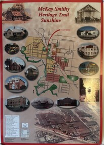
Poster - Smithy Heritage Trail Sunshine Launch Poster, 2002
... This poster was used at the launch of the S&DHS Smithy Heritage Trail brochure...A poster of the Smithy Heritage Trail Launch...Smithy Heritage Trail Sunshine...This poster was used at the launch of the S&DHS Smithy Heritage Trail brochure Smithy Blacksmith Barclay Reserve Albion Smithy Heritage Trail Sunshine A poster of the Smithy Heritage Trail Launch Poster Smithy Heritage Trail Sunshine Launch Poster ...This poster was used at the launch of the S&DHS Smithy Heritage Trail brochureSmithy Heritage Trail Sunshinesmithy, blacksmith, barclay reserve, albion -
 Wangaratta RSL Sub Branch
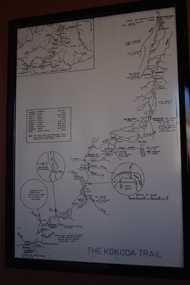
Map - Framed Map, Kokoda Trail
... Kokoda Trail...Map of the Kokoda Trail terrain to scale with approximate travel times depending on fitness and conditions....The Kokoda Trail...Wangaratta RSL Sub Branch 2-4 Templeton Street Wangaratta high-country Map of the Kokoda Trail terrain to scale with approximate travel times depending on fitness and conditions. kokoda new guinea ww2 The Kokoda Trail Black frame containing map of terrain in black on white paper Kokoda Trail Map Framed Map ...Map of the Kokoda Trail terrain to scale with approximate travel times depending on fitness and conditions.Black frame containing map of terrain in black on white paperThe Kokoda Trailkokoda, new guinea, ww2 -
 Lara RSL Sub Branch
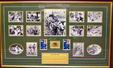
Framed collection of the Kokoda Trail, The Kodoka Trail, Circa 2018
... The Kodoka Trail....The Kokoda Track (or Trail) is a single-file thoroughfare that runs 96 kilometres (60ml) overland) - 60 kilometres (37ml) in a straight line - through the Owen Stanley Range in Papua New Guinea (PNG).The trail was First used by Europeans in the 1890s by miners struggling northwards to the Yodda Kokoda goldfields. ...The Kododa Trail....The Kodoka Trail. Framed collection of the Kokoda Trail. ...The Kokoda Track (or Trail) is a single-file thoroughfare that runs 96 kilometres (60ml) overland) - 60 kilometres (37ml) in a straight line - through the Owen Stanley Range in Papua New Guinea (PNG).The trail was First used by Europeans in the 1890s by miners struggling northwards to the Yodda Kokoda goldfields. During the Pacific War of World War 2 a series of battles were fought from July 1942 to January 1943 between Japanese and Australian forces.One of the bloodiest campaigns of World War 2,which has forever sealed the relation ship between Australia and Papua New Guinea began 61 years ago. This Photographic Memorial is dedicated to those Australian and Papua New Guinea forces who fought against the Japanese with courage and fortitude on the Kokoda Trail.Rectangular shaped glass covered picture frame showing a collection of photos,two flags and a Rising sun badge. The Kododa Trail.kokoda track, world war 2, papua new guinea, australian forces, lara r.s.l. -
 Sunshine and District Historical Society Incorporated
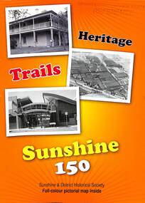
Pamphlet - Heritage Trails Sunshine 150 Brochure, Sunshine & District Historical Society, 2010
... This brochure is based on an earlier brochure, the McKay Smithy Heritage Trail, Sunshine, 2002, and is produced by the Sunshine & District Historical Society and Briimbank City Council - Celbrating Sunshine 150 years...Heritage Trails Sunshine 150...This brochure is based on an earlier brochure, the McKay Smithy Heritage Trail, Sunshine, 2002, and is produced by the Sunshine & District Historical Society and Briimbank City Council - Celbrating Sunshine 150 years Sunshine Tour Heritage Trails Sunshine 150 Fold out brochure with map and text about various points of interest within the Sunshine Districy Pamphlet Heritage Trails Sunshine 150 Brochure Sunshine & District Historical Society ...This brochure is based on an earlier brochure, the McKay Smithy Heritage Trail, Sunshine, 2002, and is produced by the Sunshine & District Historical Society and Briimbank City Council - Celbrating Sunshine 150 yearsHeritage Trails Sunshine 150sunshine, tour -
 Marysville & District Historical Society
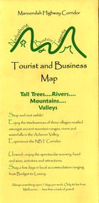
Map (Item) - Tourist and business map, Narbethong Community and Tourism Group, Narbethong Buxton Taggerty Tourist and Business Map, 04-2008
... It was produced to promote the natural attractions, adventure activities and food trail from the Black Spur, through Narbethong, Buxton and Taggerty....It was produced to promote the natural attractions, adventure activities and food trail from the Black Spur, through Narbethong, Buxton and Taggerty....This publication has been produced by the Narbethong Community and Tourism/ Group (NCTG) to promote the natural attractions, adventure activities and food/ trail from the Black Spur, through Narbethong, Buxton and Taggerty./ the information provided in this publication has been supplied by the individual/ members. ...It was produced to promote the natural attractions, adventure activities and food trail from the Black Spur, through Narbethong, Buxton and Taggerty. ...A tourist and business map of Narbethong, Buxton and Taggerty. This map was produced by the Narbethong Community and Tourism Group in April 2008. It was produced to promote the natural attractions, adventure activities and food trail from the Black Spur, through Narbethong, Buxton and Taggerty.A tourist and business map of Narbethong, Buxton and Taggerty.This publication has been produced by the Narbethong Community and Tourism/ Group (NCTG) to promote the natural attractions, adventure activities and food/ trail from the Black Spur, through Narbethong, Buxton and Taggerty./ the information provided in this publication has been supplied by the individual/ members. NCTG takes no responsibility for its accuracy./ April 2008narbethong, buxton, taggerty, victoria, australia, tourist and business map, narbethong community and tourism group, acheron valley, yarra track, wood's point, black spur, mystic mountains, the meeting of the waters, cathedral range, danico design counted cross stitch, things of sand & stone, buxton zoo nursery & oddz & enz, willowbank at taggerty, safe trek 4wd services, pnl 4wdriving, buxton trout and salmon farm, mystic mountains ski hire & outdoors, narbethong ski hire, highwood health centre, cathedral view natural therapies, narby cabinets, plants by shelian, gb timber, executive signs, rb automotive repairs, buxton car care, marysville towing & equipment hire, martyn slade building design, cathedral peak framing, black spur roadhouse & ski hire, tudor lodge roadhouse & ski hire, buxton roadhouse & persian bazzar, buxton post office general store & niche bar, igloo roadhouse, taggerty store, narby eggs, marapana agistment park, mantirri blueberry farm, carmyle farm, hazelwood hazelnuts, south cathedral lavender farm, cathedral cherries, black spur motel & caravan park, woodlands rainforest retreat, chestnut glade, black spur inn, wombat cottage, abbey lake luxury b & b spa cottages, blue views holiday cottages, camp narbethong, marapana farm stay b & b, mantirri blueberry farm b & b, little dene garden cottages, silverstream b & b cottages, nareen cabins, moondai farm b & b, south cathedral farm luxury b & b cottages, yarrolyn caravan park, sarsens rest, lomah retreat, pinjarra gardens, kingbilli country estate, henry viii manor house, buxton hotel, butters cafe of buxton, wagtail wines, little river wines, lanterns at willowbank, wirrawilla rainforest walk, wilhemina falls, the cascades -
 Marysville & District Historical Society
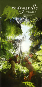
Map (Item) - Walking map, Department of Sustainability and Environment, marysville TRAILS, 07-2011
... A map showing all the walking trails in and around Marysville and the district. ...A map showing all the walking trails in and around Marysville and the district....A map showing all the walking trails in and around Marysville and the district. marysville victoria australia marysville trails department of sustainability and environment parks victoria steavenson falls trail beauty spot trail gilberts gully trail tree fern gully trail michaeldene trail wilks creek trail keppel lookout trail lady talbot drive taggerty cascades the beeches keppel falls phantom falls cathedral range state park cambarville lake mountain trails cumberland falls mystic mountains tourism ISBN 978-1-74287-122-6 (print) A map showing all the walking trails in and around Marysville and the district. marysville TRAILS Map Walking map Department of Sustainability and Environment ...A map showing all the walking trails in and around Marysville and the district. This map was produced by the Department of Sustainability and Environment in July 2011.A map showing all the walking trails in and around Marysville and the district.ISBN 978-1-74287-122-6 (print)marysville, victoria, australia, marysville trails, department of sustainability and environment, parks victoria, steavenson falls trail, beauty spot trail, gilberts gully trail, tree fern gully trail, michaeldene trail, wilks creek trail, keppel lookout trail, lady talbot drive, taggerty cascades, the beeches, keppel falls, phantom falls, cathedral range state park, cambarville, lake mountain trails, cumberland falls, mystic mountains tourism -
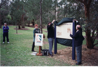
 Sunshine and District Historical Society Incorporated
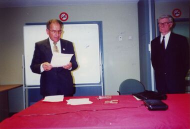
Photograph - Smithy Heritage Trail Brochure And Map Launch Photographs, Anne Best, 13th June 2002
... McKay Smithy Heritage Trail Brochure and Map in the conference room Sunshine Library, Hampshire Road, Sunshine. ...702.01 - Smithy Heritage Trail Brochure And Map Launch - Cr. Sam David And Ray Carlton.jpg 702.02 - Smithy Heritage Trail Brochure And Map Launch - MP Nicola Roxon.jpg 702.03 - Smithy Heritage Trail Brochure And Map Launch - MP Nicola Roxon.jpg 702.04 - Smithy Heritage Trail Brochure And Map Launch - Olwen Ford.jpg 702.05 - Smithy Heritage Trail Brochure And Map Launch - Ray Carlton And Olwen Ford.jpg 702.06 - Smithy Heritage Trail Brochure And Map Launch - MP Nicola Roxon.jpg 702.07 - Smithy Heritage Trail Brochure And Map Launch - Olwen Ford And Unknown.jpg 702.08 - Smithy Heritage Trail Brochure And Map Launch - Cr. ...Sunshine Heritage 702.01 - Smithy Heritage Trail Brochure And Map Launch - Cr. Sam David And Ray Carlton.jpg 702.02 - Smithy Heritage Trail Brochure And Map Launch - MP Nicola Roxon.jpg 702.03 - Smithy Heritage Trail Brochure And Map Launch - MP Nicola Roxon.jpg 702.04 - Smithy Heritage Trail Brochure And Map Launch - Olwen Ford.jpg 702.05 - Smithy Heritage Trail Brochure And Map Launch - Ray Carlton And Olwen Ford.jpg 702.06 - Smithy Heritage Trail Brochure And Map Launch - MP Nicola Roxon.jpg 702.07 - Smithy Heritage Trail Brochure And Map Launch - Olwen Ford And Unknown.jpg 702.08 - Smithy Heritage Trail Brochure And Map Launch - Cr. ...This collection of colour photographs documents the 2002 launch of the H. V. McKay Smithy Heritage Trail Brochure and Map in the conference room Sunshine Library, Hampshire Road, Sunshine. The photographs feature MP Nicola Roxon, Cr. Sam David and members of the Sunshine and District Historical Society.702.01 - Smithy Heritage Trail Brochure And Map Launch - Cr. Sam David And Ray Carlton.jpg 702.02 - Smithy Heritage Trail Brochure And Map Launch - MP Nicola Roxon.jpg 702.03 - Smithy Heritage Trail Brochure And Map Launch - MP Nicola Roxon.jpg 702.04 - Smithy Heritage Trail Brochure And Map Launch - Olwen Ford.jpg 702.05 - Smithy Heritage Trail Brochure And Map Launch - Ray Carlton And Olwen Ford.jpg 702.06 - Smithy Heritage Trail Brochure And Map Launch - MP Nicola Roxon.jpg 702.07 - Smithy Heritage Trail Brochure And Map Launch - Olwen Ford And Unknown.jpg 702.08 - Smithy Heritage Trail Brochure And Map Launch - Cr. Sam David, Olwen Ford, MP Nicola Roxon, Ray Carlton And Unknown.jpg 702.09 - Smithy Heritage Trail Brochure And Map Launch - Cr. Sam David, Olwen Ford, MP Nicola Roxon, Ray Carlton And Unknown.jpg 702.10 - Smithy Heritage Trail Brochure And Map Launch - MP Nicola Roxon And Tom Rigg.jpg 702.11 - Smithy Heritage Trail Brochure And Map Launch - Tom Rigg And Cr. Sam David.jpg 702.12 - Smithy Heritage Trail Brochure And Map Launch - Olwen Ford.jpg 702.13 - Smithy Heritage Trail Brochure And Map Launch - Ray Carlton And Olwen Ford.jpg 702.14 - Smithy Heritage Trail Brochure And Map Launch - MP Nicola Roxon.jpg 702.15 - Smithy Heritage Trail Brochure And Map Launch - Ray Carlton.jpg 702.16 - Smithy Heritage Trail Brochure And Map Launch - Unknowns.jpg 702.17 - Smithy Heritage Trail Brochure And Map Launch - Crowd.jpg 702.18 - Smithy Heritage Trail Brochure And Map Launch - Crowd.jpg 702.19 - Smithy Heritage Trail Brochure And Map Launch - Crowd.jpg 702.20 - Smithy Heritage Trail Brochure And Map Launch - Unknown And Olwen Ford.jpg 702.21 - Smithy Heritage Trail Brochure And Map Launch - Frank Ford, Unknown And Unknown.jpg 702.22 - Smithy Heritage Trail Brochure And Map Launch - Cr. Sam David, Olwen Ford, MP Nicola Roxon, Ray Carlton And Unknown.jpgsunshine, heritage -
 Vision Australia
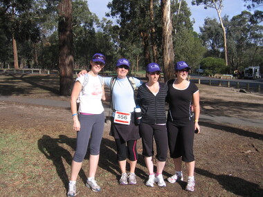
Photograph - Image, 2009 Vision Australia Oxfam Trail Walker team, 2009
... 2009 Vision Australia Oxfam Trail Walker team..., Kate Randall, are ready to tackle the 2009 Oxfam Trail Walker challenge....Coloured photograph of four women ready to head out on Trail Walker..., Kate Randall, are ready to tackle the 2009 Oxfam Trail Walker challenge. Vision Australia Oxfam Kate Gniel Kate Randall Coloured photograph of four women ready to head out on Trail Walker 2009 Vision Australia Oxfam Trail Walker team Photograph Image ...Vision Australia staff members: Kate Gniel, ?, ?, Kate Randall, are ready to tackle the 2009 Oxfam Trail Walker challenge.Coloured photograph of four women ready to head out on Trail Walkervision australia, oxfam, kate gniel, kate randall -
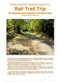 Orbost & District Historical Society
Booklet - Rail Trail Trip, John Phillips, The Newmerella Blasting Accident Site, Tuesday 15th October, 2024, 2025
... The cover page has a large coloured photograph of a trail through bushland. The writing on the cover is in orange print. ...Orbost & District Historical Society Inc RAIL TRAIL TRIP To Newmerella Blasting Accident Site Tuesday 15th October, 2024...The Newmerella Blasting Accident Site, Tuesday 15th October, 2024 Booklet Rail Trail Trip John Phillips ...This booklet records the trip made by members of the Orbost and District Historical Society (including Heather Terrell, Roy Hofen and Eddie Slatter) on 15 October 2024 to view sites associated with the 1914 blasting accident site at Newmerella. Others attending were Noreen Thomson, May Leatch, Gaye Pearson, Lois Crisp, Heather Terrel, John Philips and Geoff Stevenson. This blasting accident which killed three workers occurred during construction of the Bairnsdale - Orbost railway line. It involved two men, a father and son from the same family (John and Peter Carroll) and another worker John Sullivan, all of whom died. It was the worst accident to occur during construction of this railway. This booklet is significant because it records details of the site where the deaths of three men working on the railway construction at Newmerella occurred, located about two miles west of Orbost. John and Peter Carroll and John Sullivan 13th of March 1914 died in this accident. 11 page plastic covered booklet. The cover page has a large coloured photograph of a trail through bushland. The writing on the cover is in orange print. Orbost & District Historical Society Inc RAIL TRAIL TRIP To Newmerella Blasting Accident Site Tuesday 15th October, 2024railway blasting accident 1914, railway construction deaths, carroll, sullivan -
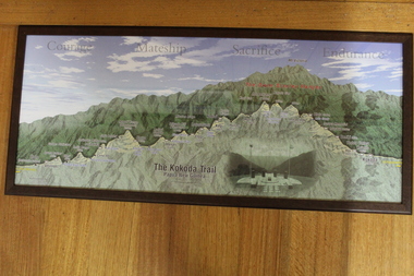 Lara RSL Sub Branch
Photograph The Kokoda Trail - "Courage, Mateship, Sacrifice, Endurance", Kokoda Trail - "Courage, Mateship, Sacrifice, Endurance"
... Kokoda Trail - "Courage, Mateship, Sacrifice, Endurance"...Tourist map of the Kokoda Trail, Owen Stanly Ranges - IIolo to Kokoda, Papua to New Guinea...Picture Kokoda Trail - Papua New Guinea - Owen Stanley Ranges showing a cut through to emphasize the variation in height in the Ranges, with left to right of the villages and townships that represent the trail. ...Lara RSL Sub Branch McClelland Ave Lara Tourist map of the Kokoda Trail, Owen Stanly Ranges - IIolo to Kokoda, Papua to New Guinea Graphical map of the Kokoda Trail kokoda trail owen stanley ranges None Picture Kokoda Trail - Papua New Guinea - Owen Stanley Ranges showing a cut through to emphasize the variation in height in the Ranges, with left to right of the villages and townships that represent the trail. ...Tourist map of the Kokoda Trail, Owen Stanly Ranges - IIolo to Kokoda, Papua to New GuineaGraphical map of the Kokoda TrailPicture Kokoda Trail - Papua New Guinea - Owen Stanley Ranges showing a cut through to emphasize the variation in height in the Ranges, with left to right of the villages and townships that represent the trail. Also contains an inset picture of the Memorial at Isurava Village.Nonekokoda trail, owen stanley ranges -
 Marysville & District Historical Society
Ephemera (Item) - Information brochure, Artworkz Tourism, MARYSVILLE-MICHAELDENE NATURE TRAIL WALK, 04-01-2020
... MARYSVILLE-MICHAELDENE NATURE TRAIL WALK...An information brochure on the Michaeldene Nature Trail Walk in Marysville. This brochure was produced by Artworkz Tourism in January 2020....An information brochure on the Michaeldene Nature Trail Walk in Marysville. This brochure was produced by Artworkz Tourism in January 2020....MARYSVILLE-MICHAELDENE NATURE TRAIL WALK Ephemera Information brochure Artworkz Tourism ...An information brochure on the Michaeldene Nature Trail Walk in Marysville. This brochure was produced by Artworkz Tourism in January 2020.An information brochure on the Michaeldene Nature Trail Walk in Marysville.Disclaimer: The authors have taken care to ensure this/ publication is correct, though please be aware that/ errors and omissions do occur.marysville, victoria, australia, information brochure, artworkz tourism, michaeldene nature trail walk, michaeldene walking track -
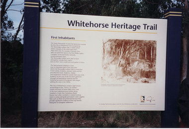
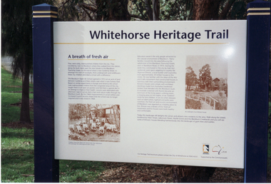
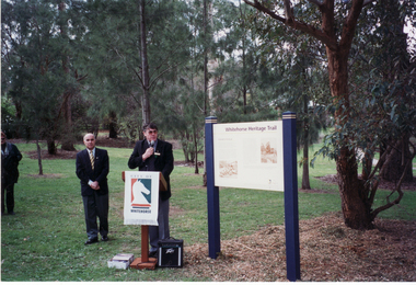
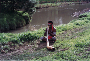 Whitehorse Historical Society Inc.
Photograph, Opening of Whitehorse Heritage Trail, 2/07/2001 12:00:00 AM
... Opening of Whitehorse Heritage Trail...Heritage Trail funded by grant to the City of Whitehorse from Commonwealth of Australia to celebrate 100 years of Federation....Coloured photograph of an aborigine playing Didgeridoo at opening of Whitehorse Heritage Trail at Gardiners Creek Reserve, Burwood....Opening of Whitehorse Heritage Trail Photograph Photograph ...Heritage Trail funded by grant to the City of Whitehorse from Commonwealth of Australia to celebrate 100 years of Federation.Coloured photograph of an aborigine playing Didgeridoo at opening of Whitehorse Heritage Trail at Gardiners Creek Reserve, Burwood.whitehorse heritage trail, city of whitehorse, gardiners creek reserve, didgeridoo -
 Whitehorse Historical Society Inc.
Photograph, Opening of Whitehorse Heritage Trail, 2/07/2001 12:00:00 AM
... Opening of Whitehorse Heritage Trail...Heritage Trail funded by grant to the City of Whitehorse from Commonwealth of Australia to celebrate 100 years of Federation....Bill Bowie, Mayor of City of Whitehorse, Speaking at opening of Whitehorse Heritage Trail....Bill Bowie, Mayor of City of Whitehorse, Speaking at opening of Whitehorse Heritage Trail. Opening of Whitehorse Heritage Trail Photograph Photograph ...Heritage Trail funded by grant to the City of Whitehorse from Commonwealth of Australia to celebrate 100 years of Federation.Coloured photograph of Cr. Bill Bowie, Mayor of City of Whitehorse, Speaking at opening of Whitehorse Heritage Trail.whitehorse heritage trail, city of whitehorse -
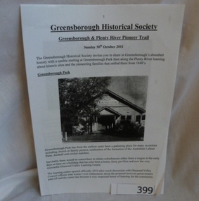 Greensborough Historical Society
Folder, Greensborough and Plenty River Pioneer Trail, 30/10/2011
... Greensborough and Plenty River Pioneer Trail...Trail notes from the Greensborough Historical Society Heritage Weekend Walk, Sunday 30th October 2011. ...20-page plastic binder, spiral bound, clear cover. Contains trail notes. 6 pages, illus....Folder commenced 2012. 20-page plastic binder, spiral bound, clear cover. Contains trail notes. 6 pages, illus. Greensborough and Plenty River Pioneer Trail Folder Greensborough Historical Society ...Trail notes from the Greensborough Historical Society Heritage Weekend Walk, Sunday 30th October 2011. Contains illustrations and information on historical sites within easy walk of Greensborough central.20-page plastic binder, spiral bound, clear cover. Contains trail notes. 6 pages, illus.Collected by Greensborough Historical Society. Folder commenced 2012.greensborough historical society, plenty river pioneer trail, noel withers, greensborough -
Marysville & District Historical Society
Ephemera (Item) - Information brochure, Artworkz Tourism, MARYSVILLE-BEAUTY SPOT NATURE TRAIL WALK, 04-01-2020
... MARYSVILLE-BEAUTY SPOT NATURE TRAIL WALK...An information brochure on the Beauty Spot Nature Trail Walk in Marysville. This brochure was produced by Artworkz Tourism in January 2020....An information brochure on the Beauty Spot Nature Trail Walk in Marysville. This brochure was produced by Artworkz Tourism in January 2020....MARYSVILLE-BEAUTY SPOT NATURE TRAIL WALK Ephemera Information brochure Artworkz Tourism ...An information brochure on the Beauty Spot Nature Trail Walk in Marysville. This brochure was produced by Artworkz Tourism in January 2020.An information brochure on the Beauty Spot Nature Trail Walk in Marysville.Disclaimer: The authors have taken care to ensure this/ publication is correct, though please be aware that/ errors and omissions do occur.marysville, victoria, australia, information brochure, artworkz tourism, beauty spot nature trail walk -
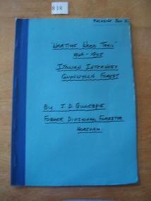 Stawell Historical Society Inc
Book, J D Gillespie, War Time Wood Trail 1942 - 1945. Italian Internees Glynwylln Forest, 1989
... War Time Wood Trail 1942 - 1945. Italian Internees Glynwylln Forest...Book written for the Historical Society on the occasion of a trip following the wartime wood trail to Glywylln Forest..."Wartime Wood Trail" 1942-1945 Italian Internees Glynwylln Forest By J.D. ...Stawell Historical Society Inc 46 Longfield St Stawell grampians Book written for the Historical Society on the occasion of a trip following the wartime wood trail to Glywylln Forest stawell ww2 "Wartime Wood Trail" 1942-1945 Italian Internees Glynwylln Forest By J.D. ...Book written for the Historical Society on the occasion of a trip following the wartime wood trail to Glywylln ForestBlue card cover with blue tape over staple on the spine. Handwritten title with Authors name"Wartime Wood Trail" 1942-1945 Italian Internees Glynwylln Forest By J.D. Gillespie Former Divisional Forester Horshamstawell ww2 -
 Whitehorse Historical Society Inc.
Photograph, Opening of Whitehorse Heritage Trail, 2/07/2001 12:00:00 AM
... Opening of Whitehorse Heritage Trail...Heritage Trail funded by grant to the City of Whitehorse from Commonwealth of Australia to celebrate 100 years of Federation....Coloured photograph of Display Panel commemorating the first inhabitants at opening of Whitehorse Heritage Trail at Gardiners Creek Reserve, Burwood....Opening of Whitehorse Heritage Trail Photograph Photograph ...Heritage Trail funded by grant to the City of Whitehorse from Commonwealth of Australia to celebrate 100 years of Federation.Coloured photograph of Display Panel commemorating the first inhabitants at opening of Whitehorse Heritage Trail at Gardiners Creek Reserve, Burwood.whitehorse heritage trail, city of whitehorse -
Marysville & District Historical Society
Ephemera (Item) - Information brochure, Artworkz Tourism, MARYSVILLE-TREE FERN GULLY NATURE TRAIL WALK, 04-01-2020
... MARYSVILLE-TREE FERN GULLY NATURE TRAIL WALK...An information brochure on the Tree Fern Gully Nature Trail Walk in Marysville. This brochure was produced by Artworkz Tourism in January 2020....An information brochure on the Tree Fern Gully Nature Trail Walk in Marysville. This brochure was produced by Artworkz Tourism in January 2020....MARYSVILLE-TREE FERN GULLY NATURE TRAIL WALK Ephemera Information brochure Artworkz Tourism ...An information brochure on the Tree Fern Gully Nature Trail Walk in Marysville. This brochure was produced by Artworkz Tourism in January 2020.An information brochure on the Tree Fern Gully Nature Trail Walk in Marysville.Disclaimer: The authors have taken care to ensure this/ publication is correct, though please be aware that/ errors and omissions do occur.marysville, victoria, australia, information brochure, artworkz tourism, tree fern gully nature trail walk, tree fern gully walk -
 Whitehorse Historical Society Inc.
Photograph, Opening of Whitehorse Heritage Trail, 2/07/2001 12:00:00 AM
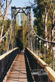
... Opening of Whitehorse Heritage Trail...Heritage Trail funded by grant to the City of Whitehorse from Commonwealth of Australia to celebrate 100 years of Federation....Part of the Whitehorse Heritage Trail....Part of the Whitehorse Heritage Trail. Opening of Whitehorse Heritage Trail Photograph Photograph ...Heritage Trail funded by grant to the City of Whitehorse from Commonwealth of Australia to celebrate 100 years of Federation.Coloured photograph of Display Board at Furness Park, Main Road Blackburn depicting the Open Air School. Part of the Whitehorse Heritage Trail.whitehorse heritage trail, open air school no 3580 blackburn, city of whitehorse -
 Eltham District Historical Society Inc
Photograph, Pedestrian suspension bridge over the Yarra River at Lower Plenty
... The bridge is now part of the Yarra Trails system....Colour photograph of footbridge over Yarra River, part of the Ruffey Trail just off the Main Yarra Trail near the former seminary (now Odyssey House) Lower Plenty...The bridge is now part of the Yarra Trails system. bridges yarra river lower plenty seminary blessed sacrament fathers odyssey house bonds road Colour photograph of footbridge over Yarra River, part of the Ruffey Trail just off the Main Yarra Trail near the former seminary (now Odyssey House) Lower Plenty Pedestrian suspension bridge over the Yarra River at Lower Plenty Photograph ...Odyssey House drug rehabilitation centre in Bonds Road, Lower Plenty is a distinctive landmark, especially when viewed from across the Yarra at Templestowe. It was built in the 1950’s as a seminary for the Blessed Sacrament Fathers. Because of the poor and circuitous road access, a suspension footbridge was built across the river. As well as providing easy access for the priests residents of Templestowe could attend services at the seminary. The bridge is now part of the Yarra Trails system.Colour photograph of footbridge over Yarra River, part of the Ruffey Trail just off the Main Yarra Trail near the former seminary (now Odyssey House) Lower Plentybridges, yarra river, lower plenty, seminary, blessed sacrament fathers, odyssey house, bonds road -
 City of Ballarat
Artwork, other - Public Artwork, Joe Pratt et al, Hidden Waterway, 2016
... Those images were then translated into carvings by sculptor Joe Pratt across 20 boulders creating a trail throughout the park. ...20 bluestone boulders with carvings across the surface creating a trail throughout the park ...Those images were then translated into carvings by sculptor Joe Pratt across 20 boulders creating a trail throughout the park. The artwork is of aesthetic and social significance to the people of Ballarat forest keegel joe pratt Ballarat east Pennyweight park 20 bluestone boulders with carvings across the surface creating a trail throughout the park Hidden Waterway Artwork, other Public Artwork Joe Pratt Forest Keegel ...To create 'Hidden waterway' (2016) Artist Forest Keegel held workshops with the people of Ballarat East who drew images in the park of threatened local fauna and waterbugs that once inhabited this land. Those images were then translated into carvings by sculptor Joe Pratt across 20 boulders creating a trail throughout the park. The artwork is of aesthetic and social significance to the people of Ballarat20 bluestone boulders with carvings across the surface creating a trail throughout the park forest keegel, joe pratt, ballarat east, pennyweight park -
Lakes Entrance Historical Society
Photograph - East Gippsland Aboriginal Cultural Trail, Lakes Post Newspaper, 1/12/2000 12:00:00 AM
... planning for the East Gippsland Aboriginal Cultural Trail showing Campbell Gome Richard Pearce and Jason Wilson...Black and white photograph taken during planning for the East Gippsland Aboriginal Cultural Trail showing Campbell Gome Richard Pearce and Jason Wilson...Lakes Entrance Historical Society 4 Marine Parade Lakes Entrance gippsland planning for the East Gippsland Aboriginal Cultural Trail showing Campbell Gome Richard Pearce and Jason Wilson Aboriginals People Aboriginal history Black and white photograph taken during planning for the East Gippsland Aboriginal Cultural Trail showing Campbell Gome Richard Pearce and Jason Wilson Photograph East Gippsland Aboriginal Cultural Trail Lakes Post Newspaper ...planning for the East Gippsland Aboriginal Cultural Trail showing Campbell Gome Richard Pearce and Jason WilsonBlack and white photograph taken during planning for the East Gippsland Aboriginal Cultural Trail showing Campbell Gome Richard Pearce and Jason Wilsonaboriginals, people, aboriginal history -
 Whitehorse Historical Society Inc.
Photograph, Opening of Whitehorse Heritage Trail, 2/07/2001 12:00:00 AM
... Opening of Whitehorse Heritage Trail...Heritage Trail funded by grant to the City of Whitehorse from Commonwealth of Australia to celebrate 100 years of Federation....Bill Bowie, Mayor, City of Whitehorse, speaking at opening of Whitehorse Heritage Trail Furness Reserve, Main Road Blackburn....Opening of Whitehorse Heritage Trail Photograph Photograph ...Heritage Trail funded by grant to the City of Whitehorse from Commonwealth of Australia to celebrate 100 years of Federation.Coloured photograph of Cr. Bill Bowie, Mayor, City of Whitehorse, speaking at opening of Whitehorse Heritage Trail Furness Reserve, Main Road Blackburn.whitehorse heritage trail, city of whitehorse, bowie, bill, baressi, phillip -
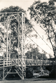 Eltham District Historical Society Inc
Photograph, Pedestrian suspension bridge over the Yarra River at Lower Plenty
... The bridge is now part of the Yarra Trails system....Two black and white photographs of footbridge over Yarra River, part of the Ruffey Trail just off the Main Yarra Trail near the former seminary (now Odyssey House) Lower Plenty...The bridge is now part of the Yarra Trails system. bridges yarra river odyssey house bonds road lower plenty seminary blessed sacrament fathers Two black and white photographs of footbridge over Yarra River, part of the Ruffey Trail just off the Main Yarra Trail near the former seminary (now Odyssey House) Lower Plenty Pedestrian suspension bridge over the Yarra River at Lower Plenty Photograph ...Odyssey House drug rehabilitation centre in Bonds Road, Lower Plenty is a distinctive landmark, especially when viewed from across the Yarra at Templestowe. It was built in the 1950’s as a seminary for the Blessed Sacrament Fathers. Because of the poor and circuitous road access, a suspension footbridge was built across the river. As well as providing easy access for the priests residents of Templestowe could attend services at the seminary. The bridge is now part of the Yarra Trails system.Two black and white photographs of footbridge over Yarra River, part of the Ruffey Trail just off the Main Yarra Trail near the former seminary (now Odyssey House) Lower Plentybridges, yarra river, odyssey house, bonds road, lower plenty, seminary, blessed sacrament fathers -
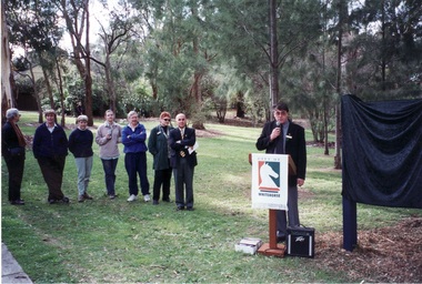
 Whitehorse Historical Society Inc.
Photograph, Opening of Whitehorse Heritage Trail, 2/07/2001 12:00:00 AM
... Opening of Whitehorse Heritage Trail...Heritage Trail funded by grant to the City of Whitehorse from Commonwealth of Australia to celebrate 100 years of Federation....Coloured photograph of opening of Whitehorse Heritage Trail at Furness Park Main Street Blackburn by the Mayor, Cr. ...Opening of Whitehorse Heritage Trail Photograph Photograph ...Heritage Trail funded by grant to the City of Whitehorse from Commonwealth of Australia to celebrate 100 years of Federation.Coloured photograph of opening of Whitehorse Heritage Trail at Furness Park Main Street Blackburn by the Mayor, Cr. Bill Bowie and Phillip Baressi, MHR and Lois Binnie, Heritage & Leisure Officer, City of Whitehorse.bowie, bill, baressi, phillip, binnie, lois, whitehorse heritage trail, city of whitehorse -
Whitehorse Historical Society Inc.
Article, Six reasons to visit Mitcham, 2015
... Including Heritage Family Day at Schwerkolt Cottage and Museum Complex, Elate Kitchen, Yarran Dheran, Boom Gate Cafe and the Eastlink Trail....An article about six venues to visit in Mitcham including Heritage Family Day at Schwerkolt Cottage and Museum Complex, Elate Kitchen, Yarran Dheran, Boom Gate Cafe and the Eastlink Trail....Whitehorse Historical Society Inc. 2-10 Deep Creek Road Mitcham melbourne Including Heritage Family Day at Schwerkolt Cottage and Museum Complex, Elate Kitchen, Yarran Dheran, Boom Gate Cafe and the Eastlink Trail. Heritage Family Day 2015 Schwerkolt Cottage and Museum Complex Elate Kitchen Yarran Dheran Boom Gate Cafe Eastlink Trail An article about six venues to visit in Mitcham. ...An article about six venues to visit in Mitcham.An article about six venues to visit in Mitcham including Heritage Family Day at Schwerkolt Cottage and Museum Complex, Elate Kitchen, Yarran Dheran, Boom Gate Cafe and the Eastlink Trail.An article about six venues to visit in Mitcham. heritage family day 2015, schwerkolt cottage and museum complex, elate kitchen, yarran dheran, boom gate cafe, eastlink trail -
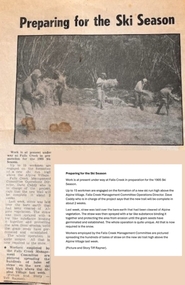 Falls Creek Historical Society
Article - Newspaper article "Last Hoot" development - Summer of 1984/85
... The Last Hoot is a one km blue ski run (piste) trail which can be used in both directions. ...This newspaper article reports on the work carried out to prepare for a new ski trail the "Last Hoot" at Falls Creek over the summer of 1984/85....The Last Hoot is a one km blue ski run (piste) trail which can be used in both directions. ...Over the summer of 1984/85 extensive regeneration work was carried out to establish the “Last Hoot”. It was a big job and took all summer to complete the work which included throwing rocks of the run, digging in cross drains and spreading the area with hay. All work was done manually. Though difficult physical work, those who dedicated their time and labour to the task have interesting memories of that time, including arriving to load up hay bales only to find the cattle from the high plains had walked across the dam wall to come and enjoy a fabulous feast! The Hoot Ski Trail has two sections. Fast Hoot is a 341 metre blue downhill run located near Falls Creek. The Last Hoot is a one km blue ski run (piste) trail which can be used in both directions. It finishes at Slalom Plaza in Falls Creek Village. Snowlands Lodge is near the bottom of the trail in Slalom Street. One of its most popular features is “The Last Hoot” Restaurant.This article is significant because it documents the work carried out to establish a popular ski trail at Falls Creek, VictoriaThis newspaper article reports on the work carried out to prepare for a new ski trail the "Last Hoot" at Falls Creek over the summer of 1984/85.In image L to R Debbie Howie, Larraine Boulton, Nina Frueauf, Rob McEwan, Eric Napierthe last hoot, deb howie -
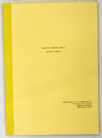 Orbost & District Historical Society
document, BALDWIN SPENCER TRAIL Project Brief 1988, February 1988
... BALDWIN SPENCER TRAIL Project Brief 1988...The Baldwin Spencer Trail closely follows the route of scientist and explorer William Baldwin Spencer. ...A document of 10 pp with a cream cover, titled, Baldwin Spencer Trail Project Brief Feb 1988. It contains maps...Baldwin-Spencer A document of 10 pp with a cream cover, titled, Baldwin Spencer Trail Project Brief Feb 1988. It contains maps BALDWIN SPENCER TRAIL Project Brief 1988 document Department of Conservation, Forests and Lands ...This document was produced by the Department of Conservation, Forests & Land Management, Orbost, to commemorate the visit by Baldwin-Spencer in 1989 as part of the Bicentennial Walking Tracks Project. The Baldwin Spencer Trail closely follows the route of scientist and explorer William Baldwin Spencer. Sir Walter Baldwin Spencer KCMG (23 June 1860 – 14 July 1929) was an English-Australian biologist and anthropologist. this booklet is a useful reference tool.A document of 10 pp with a cream cover, titled, Baldwin Spencer Trail Project Brief Feb 1988. It contains mapsbaldwin-spencer -
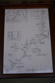 Wangaratta RSL Sub Branch
Map - Framed Map
... The Kokoda Trail...Wangaratta RSL Sub Branch 2-4 Templeton Street Wangaratta high-country kokoda trail papua new guinea world war 2 The Kokoda Trail Brown timber frame containing black and white map. ...Brown timber frame containing black and white map. Has two squares top left side and lower half contains three circles. The Kokoda Trailkokoda trail, papua new guinea, world war 2