
Showing 15 items matching "trajectories "
-
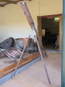 Parks Victoria - Port Campbell Rocket Shed
Rocket launcher
... It has a pendulum and dial to measure the height trajectory. Very long wooden box with hinged lid painted a green-grey colour with four brass hinges and two rusted metal hooks....It has a pendulum and dial to measure the height trajectory. Very long wooden box with hinged lid painted a green-grey colour with four brass hinges and two rusted metal hooks. ...Rocket equipment which has been used in various lifeboat and rocket stations on the Victorian Coast. It is unclear if this is the original rocket equipment from Port Campbell. This equipment, if not original has been used in rescue operations and is identical to the equipment that has been in use at Port Campbell from C.1890 onwards.Metal, brass and timber tripod structure with a channel or trough to support the rocket. It has a pendulum and dial to measure the height trajectory. Very long wooden box with hinged lid painted a green-grey colour with four brass hinges and two rusted metal hooks. -
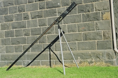 Port Fairy Historic Lifeboat Station
Equipment - Rocket Machine, c.1870
... The rocket machine allowed the rocket to be launched into a calculated trajectory, and with estimated deflection to allow for wind. ...The rocket machine allowed the rocket to be launched into a calculated trajectory, and with estimated deflection to allow for wind. ...The Boxer rocket carried a light line from shore to the wreck. The rocket machine allowed the rocket to be launched into a calculated trajectory, and with estimated deflection to allow for wind. The rockets were widely used to carry the first (connecting) line to the wreck. The rocket machine was fundamental for the successful commencement of a breeches buoy rescue. The machine could project the line beyond the effective rescue distance, and allowed the initial and vital physical connection between wreck and the shore. Boxer rocket launcher, a triangular frame to carry the rocket to preferred firing position and angle, with pendulum arrow, black exterior and grey legs (2 of) -
 Port Fairy Historic Lifeboat Station
Equipment - Rocket Machine
... The rocket machine allowed the rocket to be launched into a calculated trajectory, and with estimated deflection to allow for wind. ...The rocket machine allowed the rocket to be launched into a calculated trajectory, and with estimated deflection to allow for wind. ...The Boxer rocket carried a light line from shore to the wreck. The rocket machine allowed the rocket to be launched into a calculated trajectory, and with estimated deflection to allow for wind. The rockets were widely used to carry the first (connecting) line to the wreck.The rocket machine was fundamental for the successful commencement of a breeches buoy rescue. The machine could project the line beyond the effective rescue distance, and allowed the initial and vital physical connection between wreck and the shore.Boxer rocket launcher, a triangular frame to carry the rocket to preferred firing position and angle, with pendulum arrow, black exterior and grey legs (2 of) -
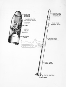 Eltham District Historical Society Inc
Photograph - Black and White Print, NASA, Four stage solid fuel Scout vehicle and cross section, 1960
... First solid fuel rocket used by N.A.S.A. to launch a satellite on orbital trajectory. Front cap comes off and satellite built of tghin mylar plastic film and aluminium foil emerges and inflates. ...First solid fuel rocket used by N.A.S.A. to launch a satellite on orbital trajectory. Front cap comes off and satellite built of tghin mylar plastic film and aluminium foil emerges and inflates. ...On reverse: Four stage solid fuel Scout vehicle and cross section of payload instrumentation. First solid fuel rocket used by N.A.S.A. to launch a satellite on orbital trajectory. Front cap comes off and satellite built of tghin mylar plastic film and aluminium foil emerges and inflates. Radio beacon built in for tracking.alan gardiner collection, space industry, 1960, nasa, rocket, scout solid fuel rocket -
 Warrnambool and District Historical Society Inc.
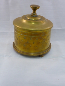
Artefact, Container (Howitzer Shell), 1917
... The 4.5 Howitzers were British artillery units made with a short barrel and used to fire missiles over a high trajectory. It is probable that the container was made by an Australian soldier while on active service overseas during World War One. ...The 4.5 Howitzers were British artillery units made with a short barrel and used to fire missiles over a high trajectory. It is probable that the container was made by an Australian soldier while on active service overseas during World War One. ...This container is a piece of trench art. It has been made in 1917 in World War One. The container is made from a 4.5 inches Howitzer shell. The 4.5 Howitzers were British artillery units made with a short barrel and used to fire missiles over a high trajectory. It is probable that the container was made by an Australian soldier while on active service overseas during World War One. This container has no known local provenance but it is a very interesting and attractive piece of World War One trench art. This is a heavy brass container made from a Howitzer shell. The container is round with four-leaf clover –type patterns on the side and three round knobs welded on to the bottom to give it a base. There are many markings on the base of the shell and these may all be the original markings. The lid is made of lighter brass and has an octagonal-shaped knob on top. ‘4.5 Howr 11’ ‘B.A. 3 3 17’ ‘1917’ M.A.C.’ etc world war one, warrnambool -
 Wangaratta RSL Sub Branch
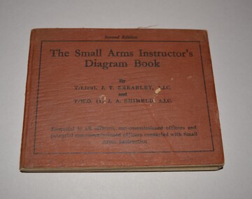
Book, Halstead Press Pty Limited, The Small Arms Instructor's Diagram Book, 1942
... The Small Arms Instructor's Diagram Book (1942) is a military training aid containing visual illustrations, mechanism plates, and trajectory diagrams used by Commonwealth forces during World War II. ...The Small Arms Instructor's Diagram Book (1942) is a military training aid containing visual illustrations, mechanism plates, and trajectory diagrams used by Commonwealth forces during World War II. ...The Small Arms Instructor's Diagram Book (1942) is a military training aid containing visual illustrations, mechanism plates, and trajectory diagrams used by Commonwealth forces during World War II. Booklet belonged to Robert Francis ISKOV VX15237 born at Glenrowan served with the 59th Battalion CMF before joining the 2/14th Battalion at Caulfield in September 1940. He disembarked for the Middle East in November, 1940 and fought in the Syrian campaign in 1941. In 1942 the 2/14th Battalion returned to Australia and sent to Papua where he fought at the Battle of Isurava before the battalion was sent to Gona. On 1943 Bob returned to Australia to undertake officer training and in 1945 with the 2/23rd Battalion sailed to Morotai and served with the battalion on Tarakan. He returned to Australia in November, 1945 and discharged a month later.A monograph publication by T/Lieut. J. T Brearley and T/W.O (1) J.A.ShimeldBrown cloth covered hard cover book containing 92 pages mainly of diagrams.Second Editionww2, new guinea, 1942, instructor's diagram book, small arms, second edition -
 Dutch Australian Heritage Centre Victoria
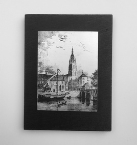
Etching
... It is unclear what the canal's trajectory was beyond the current city of Delft; the Delfshavense Schie canal, which connects Delft to the Nieuwe Maas river was not dug until 1389. ...It is unclear what the canal's trajectory was beyond the current city of Delft; the Delfshavense Schie canal, which connects Delft to the Nieuwe Maas river was not dug until 1389. ...The Vliet is a canal in the western Netherlands, in the province of South Holland. It starts at the Oude Rijn at Leiden and joins the Delfshavense Schie canal at Delft. Places along its banks include Voorschoten, Leidschendam, Voorburg, The Hague and Rijswijk. The canal was dug in 47 AD under command of Roman general Corbulo, who wished to connect the river Rhine, of which the current Oude Rijn stream in Roman times was the main branch, to the Meuse estuary. It is unclear what the canal's trajectory was beyond the current city of Delft; the Delfshavense Schie canal, which connects Delft to the Nieuwe Maas river was not dug until 1389. In the Middle Ages the Vliet was an important trade link that attracted all kinds of trade, as it flowed through the heart of the County of Holland. Windmills have been constructed alongside the Vliet, including the completely renovated mill 'De salamander' in Leidschendam. The Vliet area was particularly attractive among richer families, who built their mansions along its banks.An historic small town scene etched (or possibly printed) on thin metal and subsequently fastened to a plywood backing. The delicately presented scene is said to show the intersection of Old Church Street and the Vliet Canal bridge in Voorburg, as well as a section of wharf. On the canal are one large and two much smaller vessels. A very tall crane-like construction arises from the wharf to the roof of waterside buildings. The people are soberly dressed in possibly 17th or 18th century costumes.On the reverse has been written: "Oude Kerkstraat Brug over de Vliet Voorburg". (Old Church Street; Bridge over the Vliet canal; Voorburg). However, research proves that the church is actually the Old Church in Delft, a short distance further down the Vliet Canal. -
 Flagstaff Hill Maritime Museum and Village
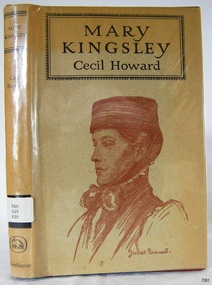
Book - Biography, Cecil Howard, Mary Kingsley, 1957
... It later merged into larger publishing houses when Hutchinson became part of Century Hutchinson, then Random House, and today sits within the Penguin Random House group UK, a fairly typical trajectory for a mid-sized independent British publisher of that era....It later merged into larger publishing houses when Hutchinson became part of Century Hutchinson, then Random House, and today sits within the Penguin Random House group UK, a fairly typical trajectory for a mid-sized independent British publisher of that era. ...Mary Kingsley is a popular biography of Mary Henrietta Kingsley (1862–1900), the English explorer, travel writer, and self-taught ethnographer known for her solo travels through West Africa (Sierra Leone, Angola, Gabon, Cameroon) in 1893–95. She collected zoological specimens for the British Museum, wrote sympathetically about African religions, law, and customs that challenged many contemporary European prejudices of the time, and published two influential books of her own: Travels in West Africa (1897) and West African Studies (1899). She died of typhoid while nursing Boer prisoners during the Second Boer War in 1900. Howard's book retells her life and travels for a general readership, and descriptions call it a lively account drawn from "the raciest and most exciting passages" of her own travel writing, tracing her journeys along the Ogowe River and through West African swamps.Hard cover book. Author: Cecil Howard Publisher: Hutchinson & Co Date: 1957 Further Information: Hardcover bound with dust cover intact with portrait frontispiece lettering in black. The spine has a Library label with an inscription.non-fictionMary Kingsley is a popular biography of Mary Henrietta Kingsley (1862–1900), the English explorer, travel writer, and self-taught ethnographer known for her solo travels through West Africa (Sierra Leone, Angola, Gabon, Cameroon) in 1893–95. She collected zoological specimens for the British Museum, wrote sympathetically about African religions, law, and customs that challenged many contemporary European prejudices of the time, and published two influential books of her own: Travels in West Africa (1897) and West African Studies (1899). She died of typhoid while nursing Boer prisoners during the Second Boer War in 1900. Howard's book retells her life and travels for a general readership, and descriptions call it a lively account drawn from "the raciest and most exciting passages" of her own travel writing, tracing her journeys along the Ogowe River and through West African swamps.shipwrecked-coast, flagstaff-hill, flagstaff-hill-maritime-museum, warrnambool, maritime-museum, shipwreck-coast, flagstaff-hill-maritime-village, shipwrecked-artefact, book, pattison collection, warrnambool library, warrnambool mechanics’ institute, ralph eric pattison, corangamite regional library service, warrnambool city librarian, mechanics’ institute library, victorian library board, warrnambool books and records, warrnambool children’s library, mary kingsley, cecil howard -
 Nillumbik Shire Council
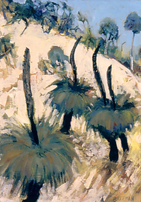
Painting: Piers BATEMAN (b.1947, Perth - d.2015, NSW), Piers Bateman, Blackboys, 1989
... His international career continued on an upwards trajectory between the Australian outback and European seas, providing a unique contrast throughout the course of his career. ...His international career continued on an upwards trajectory between the Australian outback and European seas, providing a unique contrast throughout the course of his career. ...Piers Bateman was a local artist, held in very high esteem by his peers and community. He was born in Perth in 1947, moving to Eltham in 1955 as a young child with his family. In 1966 Bateman moved to London for eighteen months to develop his craft. In 1969 he settled in St Andrews, where he built a studio. The St Andrews locale is said to have been a strong influence on his work. Bateman’s talent was such that he was promoted and mentored by such ilk as Charles Blackman, Clifton Pugh and Arthur Boyd, among others. Bateman’s work is an intimate dialogue with the environment, renowned for his paintings of the outback, wilderness frontiers and the sea. He spent a year in the mid-seventies sailing the Greek Islands and the French canals to Amsterdam. In 1980 Bateman and Marcus Skipper embarked on a trans-Australian venture to the red centre and across northern Australia from Cairns to Broome. In the mid-eighties Bateman returned to the Mediterranean, before returning to the Australian outback in the late-eighties. His international career continued on an upwards trajectory between the Australian outback and European seas, providing a unique contrast throughout the course of his career. Bateman's work questions our relationship with the natural world, and in particular, reconciling our colonial heritage with our indigenous past. This line of questioning and his genuine response to place is the key to Piers Bateman’s work, for which he is lauded and celebrated. On September 4th 2015, Piers Bateman died in a boating accident on the NSW coast line. Piers Bateman was an instinctive painter whose inspiration came from nature. He reworked and scraped off the paint, moving it around until forms and colours of the landscape took shape. Although Bateman lived in Spain and Italy, his time in Europe made him aware of the contrast between the two continents and the bright clear light that defined the Australian landscape. At the time of this work, Bateman was living in St. Andrews, but travelled regularly to New South Wales and South Australia on painting trips. The ‘Grass Tree’ Xanthorrhoea johnsonii (commonly known as ‘blackboy’) is indigenous to these areas. It is a uniquely Australian, slow growing plant with twenty-eight species growing within Australia. Old examples of this tree are survivors of many wild fires, which can cause their blackened trunk, of one to two metres, branch into two or more heads. These heads consist of thick, rough corky bark, surrounded by long, wiry leaves and flowers that produce seed capsules with hard black seeds. The tree’s ability to be one of the first to flower after a wild fire ensures a food source for many insects and birds.Oil on canvas painting. Detail of three grass trees resting on the side of a mountain/hill. Green and gold palette throughout depicting the colours and light of the Australian landscape. Hand written, low right in capitals: 'BATEMAN'bateman, grass trees, xanthorrhoea johnsonii, landscape -
 Flagstaff Hill Maritime Museum and Village
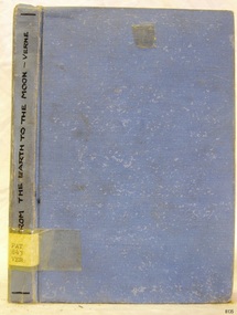
Book - A Science Fiction Story, Jules Verne, From The Earth to The Moon, Early 20th Century
... The novel focuses on the technical and organisational preparations for the voyage, with Verne's detailed calculations about the cannon, powder, trajectory, and physics of spaceflight. The French original publication was in 1865, the first English translation was issued in 1874 by Scribner, Armstrong & Company of New York USA. ...From the Earth to the Moon (1865) tells the story of the Baltimore Gun Club, a post American Civil War society of weapons enthusiasts who propose an audacious plan. This was to build a massive cannon called the Columbiad in Florida then to launch three people to the Moon in a projectile. The main characters in the story are Impey Barbicane, gun club leader, Captain Nicholl and Michel Ardan an adventurer. The novel focuses on the technical and organisational preparations for the voyage, with Verne's detailed calculations about the cannon, powder, trajectory, and physics of spaceflight. The French original publication was in 1865, the first English translation was issued in 1874 by Scribner, Armstrong & Company of New York USA. This was actually the second book by Jules Verne preceded only by “Five Weeks in a Balloon” published in 1869 that started the “Voyages Extraordinaires” series.Hard cover book, From The Earth to The Moon. Author: Jules Verne Publisher: Unknown Date: Early 20th Century. Light blue hardcover with the title on the spine having lettering to spine in black hand written text pen. fictionFrom the Earth to the Moon (1865) tells the story of the Baltimore Gun Club, a post American Civil War society of weapons enthusiasts who propose an audacious plan. This was to build a massive cannon called the Columbiad in Florida then to launch three people to the Moon in a projectile. The main characters in the story are Impey Barbicane, gun club leader, Captain Nicholl and Michel Ardan an adventurer. The novel focuses on the technical and organisational preparations for the voyage, with Verne's detailed calculations about the cannon, powder, trajectory, and physics of spaceflight. The French original publication was in 1865, the first English translation was issued in 1874 by Scribner, Armstrong & Company of New York USA. This was actually the second book by Jules Verne preceded only by “Five Weeks in a Balloon” published in 1869 that started the “Voyages Extraordinaires” series. warrnambool, shipwrecked-coast, flagstaff-hill, flagstaff-hill-maritime-museum, maritime-museum, flagstaff-hill-maritime-village, shipwrecked-artefact, book, warrnambool mechanics’ institute, pattison collection, warrnambool library, corangamite regional library service, warrnambool city librarian, mechanics’ institute library, victorian library board, warrnambool books and records, warrnambool children’s library, ralph eric pattison, jules verne, voyages extraordinaire series, l’école des robinson's -
 Monbulk RSL Sub Branch
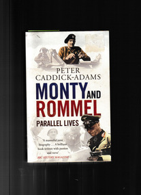
Book, Arrow, Monty and Rommel : parallel lives, 2012
... Born four years apart, the two men followed a remarkably similar trajectory. Military historian Peter Caddick-Adams explores their lives, beginning with their provincial upbringing and the brutal trench fighting of World War I--where both nearly died. ...Two men came to personify generalship in the Second World War: Bernard Montgomery for the British and Erwin Rommel for the Germans. In the span of a few years, they fought a series of extraordinary duels across several theaters of war. Ever since, historians have assessed their leadership, personalities, and skill. Born four years apart, the two men followed a remarkably similar trajectory. Military historian Peter Caddick-Adams explores their lives, beginning with their provincial upbringing and the brutal trench fighting of World War I--where both nearly died. Obsessed with fitness and training, the future field marshals emerged with glowing records. They taught in staff colleges, wrote infantry textbooks, and fought each other as divisional commanders in 1940 before taking charge of their respective armies as the war raged on. This first comparative biography of these two soldiers explores how each was "made" by their war leaders, Churchill and Hitler, and how their strategies permeate down to today's armies.Index, ill, maps, p.614.non-fictionTwo men came to personify generalship in the Second World War: Bernard Montgomery for the British and Erwin Rommel for the Germans. In the span of a few years, they fought a series of extraordinary duels across several theaters of war. Ever since, historians have assessed their leadership, personalities, and skill. Born four years apart, the two men followed a remarkably similar trajectory. Military historian Peter Caddick-Adams explores their lives, beginning with their provincial upbringing and the brutal trench fighting of World War I--where both nearly died. Obsessed with fitness and training, the future field marshals emerged with glowing records. They taught in staff colleges, wrote infantry textbooks, and fought each other as divisional commanders in 1940 before taking charge of their respective armies as the war raged on. This first comparative biography of these two soldiers explores how each was "made" by their war leaders, Churchill and Hitler, and how their strategies permeate down to today's armies.generals - germany - biography, generals - great britain - biography -
 Broadmeadows Historical Society & Museum
Photograph - Aerial Photograph
... The photograph is an important archival asset for researchers, planners, and local historians, offering a detailed snapshot of a pivotal moment in Craigieburn’s development trajectory. Aerial Photograph Craigieburn Colour aerial photograph of Craigieburn Photograph Aerial Photograph ...Craigieburn is a rapidly growing suburb located approximately 25 km north of Melbourne’s CBD. Historically, it was a rural area with agricultural roots, but since the late 20th century, it has undergone significant urban development. The transformation accelerated in the 1990s and 2000s, with large-scale residential subdivisions, infrastructure projects, and commercial developments reshaping the landscape. Key historical milestones include: Early Settlement: Originally inhabited by the Wurundjeri people of the Kulin Nation. European Settlement: Began in the mid-1800s, primarily for farming and grazing. Urban Expansion: Post-1970s, Craigieburn saw increasing suburban development, especially after the extension of rail and road infrastructure. Recent Growth: From the 2000s onward, Craigieburn became one of Melbourne’s fastest-growing suburbs, with new estates, schools, and shopping centres.This large colour aerial photograph of Craigieburn holds significant value as a visual record of the suburb’s transformation from a semi-rural landscape to a dynamic urban centre in Melbourne’s northern growth corridor. Captured during a period of rapid development, the image documents the spatial evolution of Craigieburn, including residential expansion, infrastructure projects, and the integration of green spaces and commercial zones. The photograph is historically significant as it reflects the broader patterns of post-2000 suburban growth in Victoria, driven by population pressures, housing demand, and strategic planning initiatives. It provides insight into land use changes, transport connectivity (notably the Hume Highway and Craigieburn railway line), and the emergence of community hubs such as Craigieburn Central. From a cultural heritage perspective, the image contributes to understanding the lived environment of diverse communities who have settled in Craigieburn, including its role in accommodating Melbourne’s multicultural population. It also serves as a reference point for future urban planning, environmental monitoring, and historical comparison. The photograph is an important archival asset for researchers, planners, and local historians, offering a detailed snapshot of a pivotal moment in Craigieburn’s development trajectory.Colour aerial photograph of Craigieburnaerial photograph, craigieburn -
Moorabbin Air Museum
Manual - US space programs, Press Kit Apollo 11 Lunar Landing Mission
... US space programs Mission trajectory & maneuvers Recovery operations Go/no go decision points Quarantine Lunar description Astronaut menus Technical & layman overview of Apollo 11 project for press, circa 1969 Title on inside page Press Kit Apollo 11 Lunar Landing Mission Manual US space programs ...Technical & layman overview of Apollo 11 project for press, circa 1969Title on inside page non-fictionTechnical & layman overview of Apollo 11 project for press, circa 1969mission trajectory & maneuvers, recovery operations, go/no go decision points, quarantine, lunar description, astronaut menus -
Moorabbin Air Museum
Book - Guidance systems
... Guidance systems Ballistic trajectory Hyperbolic guidance Translation Proportional navigation Stellar inertial guidance Programmed text covering fundamentals of guidance systems, circa 1967 Book Guidance systems ...Programmed text covering fundamentals of guidance systems, circa 1967non-fictionProgrammed text covering fundamentals of guidance systems, circa 1967ballistic trajectory, hyperbolic guidance, translation, proportional navigation, stellar inertial guidance -
Moorabbin Air Museum
Book - Aircraft design, Aerospace Vehicle Design Volume II Spacecraft Design
... Aircraft design Missions & projects Trajectories & orbits Error analyses & guidance Disorbit & atmospheric entry Rocket flight performance Staging & sizing Structures & structural reliability Component weight estimates Launch vehicle layout Manufacuring/testing/launching & tracking Overview of designing of vehicles to operate outside of the earth's atmosphere, circa 1964 Aerospace Vehicle Design Volume II Spacecraft Design Book Aircraft design ...Overview of designing of vehicles to operate outside of the earth's atmosphere, circa 1964non-fictionOverview of designing of vehicles to operate outside of the earth's atmosphere, circa 1964missions & projects, trajectories & orbits, error analyses & guidance, disorbit & atmospheric entry, rocket flight performance, staging & sizing, structures & structural reliability, component weight estimates, launch vehicle layout, manufacuring/testing/launching & tracking
