Showing 144 items matching "tree changers"
-
 Marysville & District Historical Society
THE TRIANGLE NEWS-VOL 39 NO 17-MAY 11 2012
... murrindindi shire tempts tree changers...Marysville & District Historical Society 39 Darwin Street Marysville yarra-valley-and-the-dandenong-ranges marysville victoria australia murrindindi shire council murrindindi shire tempts tree changers regional victoria living expo regional development victoria applauding fire heros prime minister julia gillard national emergency service medals 2009 bushfires advertisements church notices biggest morning tea miss fusspots rev andrew schreuder memorial service st john's church alexandra THE TRIANGLE NEWS-VOL 39 NO 17-MAY 11 2012 ...marysville, victoria, australia, murrindindi shire council, murrindindi shire tempts tree changers, regional victoria living expo, regional development victoria, applauding fire heros, prime minister julia gillard, national emergency service medals, 2009 bushfires, advertisements, church notices, biggest morning tea, miss fusspots, rev andrew schreuder memorial service, st john's church alexandra -
Marysville & District Historical Society
THE TRIANGLE NEWS-VOL 41 NO 7-FEBRUARY 28 2014
... murrindindi shire tempts tree changers...marysville victoria australia mayor joins with collingwood leadership team collingwood football club triangle news what's on when in march marysville p.s. parents club agm marysville sub branch rsl agm the committee of management of the gallipoli park precinct marysville community market creative triangle marysville golf report world day of prayer church notices triangle community dinner el kanah breakfast for all men new beginnings-guest speakers and dinner mayor's chair advertise your regional tourism event for free councillor comment yea pool closed saturday 1 march advertisements daytime netball nar-be-thong history book narbethong progress assocn veterans football national live theatre-warhorse marysville cultural community marysville real estate temporary road closure darwin st fire prevention irrigation systems fallons bus service alexandra marysville route service buxton hotel chinese night every wednesday in march labour day office closures community upgrade regeneration burns in central highlands and west gippsland need for feed lions club of pakenham marysville preschool long day care and kindergarten intrepid triangle bushwalkers irish band saoirse murrindindi shire tempts tree changers the michael rodger act to d-feet mnd get rid of green waste on clean up australia day free disposal of green waste murrindindi bushfire community meeting maurice blackburn lawyers buxton progress assocn rock 'n roll night at buxton hall the upper room restaurant new asian menu marysville beer & platter garden regional victorian living expo expressions of interest marysville region really long lunch THE TRIANGLE NEWS-VOL 41 NO 7-FEBRUARY 28 2014 ...marysville, victoria, australia, mayor joins with collingwood leadership team, collingwood football club, triangle news, what's on when in march, marysville p.s. parents club agm, marysville sub branch rsl agm, the committee of management of the gallipoli park precinct, marysville community market, creative triangle, marysville golf report, world day of prayer, church notices, triangle community dinner, el kanah, breakfast for all men, new beginnings-guest speakers and dinner, mayor's chair, advertise your regional tourism event for free, councillor comment, yea pool closed saturday 1 march, advertisements, daytime netball, nar-be-thong history book, narbethong progress assocn, veterans football, national live theatre-warhorse, marysville cultural community, marysville real estate, temporary road closure darwin st, fire prevention irrigation systems, fallons bus service alexandra marysville route service, buxton hotel chinese night every wednesday in march, labour day office closures, community upgrade regeneration burns in central highlands and west gippsland, need for feed, lions club of pakenham, marysville preschool long day care and kindergarten, intrepid triangle bushwalkers, irish band saoirse, murrindindi shire tempts tree changers, the michael rodger act to d-feet mnd, get rid of green waste on clean up australia day, free disposal of green waste, murrindindi bushfire community meeting, maurice blackburn lawyers, buxton progress assocn, rock 'n roll night at buxton hall, the upper room restaurant new asian menu, marysville beer & platter garden, regional victorian living expo, expressions of interest, marysville region really long lunch -
 Clunes Museum
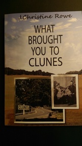
Book, CHRISTINE ROWE, What Brought you to Clunes, Nov 2015
... ...tree changers...Clunes Museum 36 Fraser Street enter building through Collins Place Clunes goldfields words in winter clunes storytelling tree changers SHORT STORIES ABOUT WHAT BROUGHT PEOPLE TO SETTLE IN CLUNES Collection of stories and photographs of people living in Clunes in 2015. ...SHORT STORIES ABOUT WHAT BROUGHT PEOPLE TO SETTLE IN CLUNESCollection of stories and photographs of people living in Clunes in 2015. Published by J. Christine Rowenon-fictionSHORT STORIES ABOUT WHAT BROUGHT PEOPLE TO SETTLE IN CLUNESwords in winter, clunes storytelling, tree changers -
Port Melbourne Historical & Preservation Society
Plan, Bay Street, C. 1990
... The Street plan shows suggestions for tree planting, verandah changes, proposed open space & building use....The Street plan shows suggestions for tree planting, verandah changes, proposed open space & building use. ...A proposed plan for the development of Bay Street, Port Melbourne. The Street plan shows suggestions for tree planting, verandah changes, proposed open space & building use.bay street, built environment - commercial -
Port Melbourne Historical & Preservation Society
Plan, Bay Street Site Analysis, C. 1990
... The Street plan shows suggestions for tree planting, verandah changes, proposed open space & building use....The Street plan shows suggestions for tree planting, verandah changes, proposed open space & building use. ...A site analysis plan for the development of Bay Street, Port Melbourne. The Street plan shows suggestions for tree planting, verandah changes, proposed open space & building use.bay street, built environment - commercial -
 Phillip Island and District Historical Society Inc.
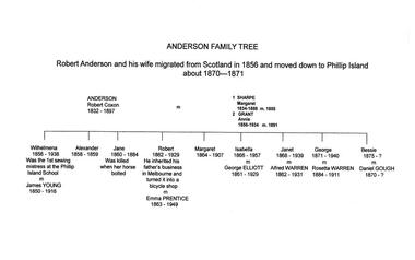
Family Tree, Anderson Family & Homestead, 1980
... The above Family Tree has been changed to Annie Grant....The above Family Tree has been changed to Annie Grant. local history documents family history family descendants from robert anderson phillip island hand printed in ink on white paper mrs emma anderson jacobs anderson family tree The Anderson' Family Tree Anderson Family & Homestead Family Tree ...Robert Anderson and wife migrated to Australia in 1856 and moved to Phillip Island about 1870 - 71. His descendants are tabulated with some brief history of them. On one Family Tree it has that Robert Coxon Anderson married Margaret Sharpe in 1855 then Bessy Flemming after Margaret died. In another Family Tree the 2nd wife is noted as Annie Grant marrying Robert in 1891. The above Family Tree has been changed to Annie Grant.The Anderson' Family Treelocal history, documents, family history, family descendants from robert anderson, phillip island, hand printed in ink on white paper, mrs emma anderson jacobs, anderson family tree -
 Bendigo Historical Society Inc.
Newspaper - JENNY FOLEY COLLECTION: ASYLUM
... The building was set on 11 acres and complemented with fruit, ornamental trees and flowers. It changed its name in 1963 to the Bendigo Home and Hospital for the Aged. ...The building was set on 11 acres and complemented with fruit, ornamental trees and flowers. It changed its name in 1963 to the Bendigo Home and Hospital for the Aged. ...Bendigo Advertiser ''The way we were'' from 2000. Asylum: Bendigo Benevolent Asylum circa 1880s. The Ionic style building in Barnard Street was opened in March 1860. The building was set on 11 acres and complemented with fruit, ornamental trees and flowers. It changed its name in 1963 to the Bendigo Home and Hospital for the Aged. The clip is in a folder.newspaper, bendigo advertiser, the way we were -
 Eltham District Historical Society Inc
Folder, Connor, Jim
... Newspaper article: Tree change a positive move, Why I love My Suburb, Diamond Valley Leader, July 24, 2019, p4 - interview with Jim Connor 9. ...Newspaper article: Tree change a positive move, Why I love My Suburb, Diamond Valley Leader, July 24, 2019, p4 - interview with Jim Connor 9. ...Eltham resident for more than 42 years, consultant in access and aged care issues, former Eltham Shire Councillor (1994), former member of Nillumbik Planning Special Committee (1996), community advocate, bike rider and President of Eltham District Historical Society from 2010 to present (2023) 1. How to Vote pamphlet: Lets make Eltham an even better place, Jim Connor for Eltham Council Central Riding - stood as an independent candidate against Nick McGowan 2. Newspaper article: Eltham's plans draw support; publication unknown (1994) - continuation of article about proposed realignment of Council boundaries and includes photo showing Cr Connor 3. Business Card: Jim Connor and associates, Consultant in Access and Aged Care Issues 4. Report: Meeting the challenge - we're well on the way! Nillumbik Budget 2005-2006 report card (8 page A4 report) featuring a photo of Nillumbik councillors and community members reviewing aerial photo of Eltham (includes Mayor Cr Greg Johnson, Cr Michael Young, Jim Connor, Russell Yeoman and two others) 5. Newspaper clipping, Local Knowledge, Diamond Valley Leader, November 2, 2011, p2 - interview with Jim Connor about living in the Diamond Valley 6. Consideration of an Honorary Life Membership for Jim Connor, Eltham District Historical Society 7. A Celebration of Community Historians at the RHSV's AGM, RHSV News, June 2019, p4 - presentation of RHSV Merit Award by RHSV President Richard Broome to Jim Connor 8. Newspaper article: Tree change a positive move, Why I love My Suburb, Diamond Valley Leader, July 24, 2019, p4 - interview with Jim Connor 9. Photo: B&W A4 print of Jim Connor with his e-bikeFolder of information on Jim Connoreltham district historical society, eltham shire council, jim connor, nillumbik shire council, royal historical society of victoria, council elections -
 Warrnambool and District Historical Society Inc.
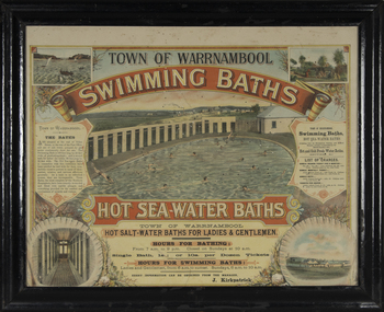
Photograph - Framed photograph of Warrnambool Salt Water Baths, c. 1920
... The change rooms are on the right side of the photograph and there is a fence with trees behind. ...The change rooms are on the right side of the photograph and there is a fence with trees behind. ...This is a framed photograph of the men's pool at the Warrnambool Salt Water Baths. These Baths were originally built at the end of Gilles Street on the line of the present railway line in 1876 but were rebuilt in 1889 further north in Gilles Street when the railway line was opened. The water was pumped from the sea, initially by a windmill and later by a gas pump. The men's pool was 100 feet by 50 feet and the women's pool was 60 feet by 30 feet with bathing strictly segregated in the 19th century. A building nearby housed marble cubicles with hot spa baths with the water heated on the site and a caretaker's cottage completed the complex. Men's nude bathing was a feature of the early 20th century. Originally built by a local public company the Baths were taken over by the Warrnambool Council. These baths were superseded by the opening in 1961 of an Olympic Pool In Warrnambool. The site and the remaining buildings of the old sea water baths are now heritage-listed and today form part of the headquarters of the Warrnambool and District Historical Society.This photograph is of historical significance as a depiction of the Warrnambool Salt water Baths in the early 20th century. These Baths were the basis for promoting Warrnambool as a health and spa resort town in the late 19th and early 20th centuries.This is a framed black and white photograph of the men's pool at the Warrnambool Salt Water Baths. It depicts men and boys swimming in the circular pool and one male on the diving board. All these men are naked. There are other clothed males and clothed attendants wearing hats and waistcoats. The change rooms are on the right side of the photograph and there is a fence with trees behind. The photograph is mounted on cardboard with a gilt edge and is held in a wooden ridged frame behind glass. warrnambool sea water baths, sea baths, warrnambool pool, gilles street -
 Warrnambool and District Historical Society Inc.
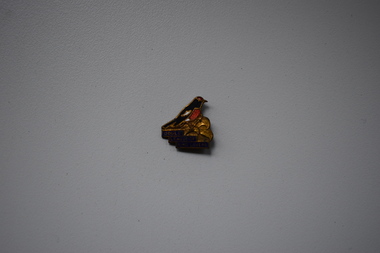
Badges, Swann & Hudson, Gould League of Bird Lovers, 1950s
... changed to Gould League and in 2006 it became Gould Group Ltd. This badge has no known local provenance but many school children in Warrnambool in the 20th century and even today have belonged to the Gould League of Bird Lovers and the badge is retained as a memento of what was once an important organization for school children in Victoria. Gould League of Bird Lovers History of Warrnambool John Gould ornithologist Gould League of Bird Lovers Swann & Hudson Frankston This is an irregular-shaped metal badge with the image of a red-capped robin, bronze-coloured tree ...This is a badge of the Gould League of Bird Lovers. This organization was formed in 1909 in Victoria and was initially sponsored by the Education Department of Victoria. It was named after the English ornithologist, John Gould and his wife Elizabeth. The initial aim was to encourage school children to protect native birds and their eggs. Today the aim of the group has been widened to include education for environmental sustainability. In 1967 the name was changed to Gould League and in 2006 it became Gould Group Ltd. This badge has no known local provenance but many school children in Warrnambool in the 20th century and even today have belonged to the Gould League of Bird Lovers and the badge is retained as a memento of what was once an important organization for school children in Victoria. This is an irregular-shaped metal badge with the image of a red-capped robin, bronze-coloured tree branch and gold printing on a blue base. The back has a metal clip.Gould League of Bird Lovers Swann & Hudson Frankston gould league of bird lovers, history of warrnambool, john gould, ornithologist -
 Kiewa Valley Historical Society
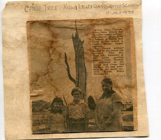
Newspaper clipping 11/7/72 Canoe tree in Kiewa & Photo-Tawonga Homestead
... tree trunk, located at Kiewa, would have been used at the beginning of European settlement in the Kiewa Valley or just before contact was made. 2. Pictorial record of the graves of early pioneers C Ibbotson, Mrs Elizabeth Eyre and John Eyre who died between 1858 – 1904, all located at Tawonga Homestead 1. The above schools are in the Kiewa Valley. The date and number of combined schools give insight into the change ...1. Kiewa Valley Consolidated School was established in 1953 combining Dederang North, Kergunyah, Gundowring, Kiewa, Gundowring Upper, Red Bluff, Charleroi and Gundowing North schools on a 10 acre site with 11 rooms at Kiewa. The bark was cut from the canoe tree, by aboriginal craftsmen, to produce a canoe for fishing in the rivers running through the Kiewa Valley either before or just after the 1800's. The tree trunk, located at Kiewa, would have been used at the beginning of European settlement in the Kiewa Valley or just before contact was made. 2. Pictorial record of the graves of early pioneers C Ibbotson, Mrs Elizabeth Eyre and John Eyre who died between 1858 – 1904, all located at Tawonga Homestead 1. The above schools are in the Kiewa Valley. The date and number of combined schools give insight into the change in population and families in the Kiewa Valley before and after 1953. The tree was found along the Kiewa River and indicates that Aborigines lived by the river and used tree bark to craft canoes to cross rivers and to fish in the deeper sections of the river. 2. Pictorial record of the early history of Kiewa Valley pioneers whose descendants have lived and worked in the Kiewa Valley for many years 1. Newspaper article of local school children visiting a canoe tree in Kiewa July 11, 1972. mounted on buff card 2. Black and white photo of pioneer graves at old Tawonga Homestead. Mounted on buff card 1. Handwritten in black ink above newspaper clipping ‘Canoe Tree Kiewa Valley Consolidated School. 11 July, 1972’ Handwritten in pencil at bottom of article ’10 Nov. ‘72’ 2. Handwritten in black ink above photo ‘Tawonga Homestead graves’ Handwritten below photo ‘T Ibbotson D. 1858, Elizabeth Eyre D. 1879, John Eyre D 1879, John Eyre D. 1904 tawonga homestead, canoe tree at kiewa, tawonga graves -
 Kiewa Valley Historical Society
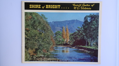
Brochure - Shire of Bright, Shire of Bright Tourist Centre of N.E. Victoria, Pre 1966
... It is interesting to see how tourism has changed (or not) in the area. tourism; mt beauty; the kiewa valley; bright shire 14 pages on glossy paper including colored and black and white photos. The front cover has the title at the top with yellow print on black background. Below the title is a large colored photo of a river, autumn trees ...Bright and the surrounding towns were developing a large tourism industry which the Shire of Bright continues to promote, encouraging tourists to visit throughout the year. This high quality brochure has magnificent photos with a map showing the area and the distance (in miles) from the centre - the township of Bright.This brochure is promoting the Shire of Bright encouraging tourism in the area. This is important for the Shire as tourism is the main industry for the Shire. It is interesting to see how tourism has changed (or not) in the area.14 pages on glossy paper including colored and black and white photos. The front cover has the title at the top with yellow print on black background. Below the title is a large colored photo of a river, autumn trees and mountain. The back cover is a large colored photo of a man amongst the snow gums in the snow. The towns covered are Bright, Wandiligong, Eurobin, Mt Buffalo, McKay Creek Power Station, The Kiewa Hydro Electric Scheme, Mt Beauty, Kiewa, Bogong including tourist destinations in these areas and their surrounds.tourism; mt beauty; the kiewa valley; bright shire -
 Kiewa Valley Historical Society
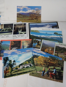
Photos, Postcards - Kiewa Valley
... trees make a show of colour during Autumn. The postcards are of historical value showing photos taken at an earlier time.The postcards can be compared to the attractions of the time as they do not include cycling (mountain bikes and road bikes), snow boarding, gliding and paragliding. Advertising for tourism has also changed ...Mt Beauty township, at the head of the Kiewa Valley, is situated at the foot of Mt Bogong. The town was established by the State Electricity Commission of Victoria during the construction of the Kiewa Hydro Electric Scheme on the High Plains.Mt Beauty is a popular tourist resort. The main highway from Mt Beauty to the Bogong High Plains is most picturesque throughout the year. During the winter months, Falls Creek provides access to Falls Creek Ski Village for snow sports. Tawonga, 6.5 km north of Mt Beauty, is famed for its trout fishing and camping on the Kiewa River. Deciduous trees make a show of colour during Autumn. The postcards are of historical value showing photos taken at an earlier time.The postcards can be compared to the attractions of the time as they do not include cycling (mountain bikes and road bikes), snow boarding, gliding and paragliding. Advertising for tourism has also changed as attractions are now available on-line. 1. 9 Coloured Photos of Bogong (5) and Visitors Information Centre display (4) 2. Two fold out coloured sets of postcards "Mt Beauty and the Kiewa Scheme", "Mt. Beauty Victoria" 3. x10 Coloured postcards Mt Beauty, Kiewa Valley, Bogong 4. x6 Coloured postcards High Country and Bogong Villagepostcards kiewa valley -
 Orbost & District Historical Society
program, Orbost Timber Ball Committee, 1996
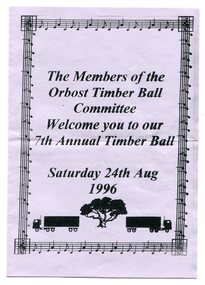
... changed. This item is reminiscent of a previous social activity. dancing recreation Orbost-timber-industry A pale mauve coloured paper folded in half as a program. Print is black. Front page is framed with a graphical musical frame. Underneath print are images of two timber trucks on either side of a tree ...This is a program for the 7th Annual Timber Ball held in August 1996. It was sponsored by the Timber Industry.Orbost has historically been based on the timber industry, but that industry has declined considerably over the last 20 years. The number of locals involved in the timber industry has declined and these balls are no longer held. Community balls and dances are becoming rarer as more home entertainment is available and musical tastes have changed. This item is reminiscent of a previous social activity.A pale mauve coloured paper folded in half as a program. Print is black. Front page is framed with a graphical musical frame. Underneath print are images of two timber trucks on either side of a tree. The wording is : "Members of the Orbost Timber Ball Committee welcome you to our 7th Annual Ball Saturday 24 August 1996.' Inside are the names of committee members and sponsors. dancing recreation orbost-timber-industry -
 Orbost & District Historical Society
Functional object - Bell, hand-held, Early 20th century, c.1900s
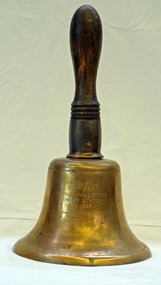
... change classes during the day as well as when students are dismissed from school. In most schools today it will be a tone, siren, electronic bell sound, a series of chimes, or music played over an intercom but often still called "the school bell". This item reflects the history of Cabbage Tree ...The settlement of Cabbage Tree Creek is located on the Princes Highway, 27 km east of Orbost in East Gippsland. The creek, which flows through undulating forest, takes its name from the patches of Cabbage Fan palms growing along its course. A school commenced classes in 1913, but enrolment was small and at times the school operated part time with several other small schools in the area. The school building served as a hall for the district. About 1946 two sawmills commenced operations at Cabbage Tree Creek, and the Forests Commission ranger was stationed in the area. The increased population allowed the school to have more teachers and make improvements. In 1953, a new prefabricated building was erected on a new site. However, by the 1970s employment in the timber industry was unstable and the population decreased. By 1974 the school again had only one teacher and eventually closed in 1993 to amalgamate with the Orbost primary School in Ruskin Street, Orbost. (Ref. VictorianPlaces)The school bell is a signal that tells a school's students when it is time to go to class in the morning and when it is time to change classes during the day as well as when students are dismissed from school. In most schools today it will be a tone, siren, electronic bell sound, a series of chimes, or music played over an intercom but often still called "the school bell". This item reflects the history of Cabbage Tree Creek as well as the technological changes in the school system.Brass bell with incised double lines on bottom edge and top near handle, featuring descriptive notation on front face. Bell has long wooden handle shaped and incised with four lines at base before brass housing with singular screw holding handle in place. Object is showing signs of wear, with blackened handle and patches of green oxidisation.SCHOOL BELL / SS No 3812 / CABBAGE TREE CREEK / PRIMARY SCHOOL / 1913-1993 / FORMALLY INCORPORATED / INTO / ORBOST / PRIMARY SCHOOL / 1994cabbage tree, east gippsland, cabbage tree creek, cabbage tree creek primary school, orbost primary school, school bells -
 Conservation Volunteers
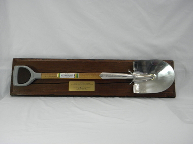
Memorabilia: Cyclone Sylvaspade, Australian Bicentenary 1988, Cyclone Sylvaspade - Senator Graham Richardson planted a tree using this spade at Sovereign Hill Outdoor Museum to mark ATCV's work at the Australian Bicentennial, 1988 (exact)
... This object is historically significant because it is a memento of a significant national event, the 200th anniversary of European settlement and the start of a process of environmental change which has had negative consequences and which demands a commitment to conserving the uniques Australian national environment. It recognised the achievement of ATCV in tree ...The spade is a memento of the planting of a tree by the responseible Commonealth Minister to recognise the contribution of ATCV and ATCV volunteers to repair of the Australian environment. At the time ATCV had been operating in Ballarat for six years. ATCV volunteers had planted 192,000 trees from April 1987- March 1988. Senator Richardson was then Minister for the Arts and the Environment in the Hawke ALP Government and on 17 November 1988 he planted a tree using this spade at Sovereign Hill Outdoor Museum (at which ATCV volunteers had planted trees which are (by 2010) fully grown and a significant feature of the site). Peter Hiscock was director of Sovereign Hill as well as President of ATCV and among the most significant leaders of ATCV (now CVA). The spade also symbolises the recovery of ATCV (then a small and struggling community group) from near closure owing to the effects of the 1987 recession. The Cyclone Sylvaspade concept was component project of the Australian Bicentennial celebrations aimed at recognising organisations which had contributed positively to conservation of Australia's environment. The concept was originated and driven by Dr Wilf Crane of the CSIRO Division of Forestry and a highly regarded forester and environmentalist and champion of the cause of rejuvenating Australia's degraded landscape with trees. At the naming of a road after him in Canberra he was described as a: "enthusiast, a man of conviction, action, humility and simplicity". Wilf conceived the project, developed the tree planting spade with Boral Cyclone and the Institute of Foresters of Australia and launched it with the then Governor-General Sir Ninian Stephens at the new Parliament House. Cyclone has been a brand name for a manufacturer of good quality hand tools for over a century. It is likely manufacturing was still done in Australia at the time of manufacture of the Sylvaspade. Much of it has now moved offshore, particuarly to China and Taiwan.This object is historically significant because it is a memento of a significant national event, the 200th anniversary of European settlement and the start of a process of environmental change which has had negative consequences and which demands a commitment to conserving the uniques Australian national environment. It recognised the achievement of ATCV in tree planting over six years. The Cyclone Sylvaspade is a practical memento and having the responsible Commonwealth Minister plant a tree with it was highly symbolic of ATCV's practical commitment to repair of our environment all over Australia. It was also used by the Victorian Premier, Hon John Brumby, to plant a tree at the reopening of the Boral Asphalt plant, Ballarat, in April 2010. The spade is No. 12 of a limited edition. This item is a functional tree planting spade called a "Cyclone Sylvaspade", mounted on a block of wood with a plaque. The handle of the spade is made of grey plastic, the haft is light, stained wood, and the blade is manufactured to resemble silver and has engravings. It was donated by the Boral company and presented to ATCV by the Minister of Arts and the Environment, Senator Graham Richardson after he had planted a tree to mark the occasion at Sovereign Hill Outdoor Museum, BallaratOn the stem of the spade here is a label showing the logo of the Boral company which reads "SYLVASPADE Tree Planting Spade - Made in Australia." On the blade is engraved "Cyclone - NUMBER 0012 - SYLVASPADE - 1788-1988" together with the logo of the Australian Bicentennial Authority. The spade is mounted on a sturdy polished wooden board on which there is a brass-coloured plate bearing the words: "PRESENTED BY SENATOR THE HON GRAHAM RICHARDSON TO AUSTRALIAN TRUST FOR CONSERVATION VOLUNTEERS IN RECOGNITION OF THEIR CONTRIBUTION TO THE ENVIRONMENT 17TH NOVEMBER 1988 DONATED BY BORAL LIMITED"of, trust, ballarat, memento, australian, australia, environment, conservation, atcv, for, volunteers, cyclone, sylvaspade, senator graham richardson, 1788 1988 australian, bicentennial, boral, spade, sovereign hill, 17th november 1988, 1988, minister for arts and environment, tree planting, institute, foresters, dr, wilf, crane -
Federation University Historical Collection
Book - Book - Scrapbook, Ballarat School of MInes: Scrapbook of Newspaper Cuttings, Book 24, April 1985 to October 1985
... The papers concerned are The Courier, Ballarat, The Australian, The Age over the period of 8 April 1985 to 10 October 1985. teaching positions advertised pre-employment courses courses available industrial electrical engineers society trevor henderson wins award geoffrey blainey launches history of the school of mines wendouree tech high wins football six-day tree seminar at old ballarat east gardens ian duggan wins welding award smb facing big changes challenges writing workshops give pleasure ania walwicz - writer artist smb's famous head - r w richards antarctic hero dies - 92 jim bell head of engineering lee wallis head of plumbing and sheet metal ballarat council to replace statue of malcolm fraser staff farewelled captain moonlight slept here carpentary at smb will be moved dick richard's obituary hairdressing seminar flagstaff college of tafe smb kim odgers first woman - certificate of technology in surveying apprentices compete in work skill finals peter brown - carpentry ricky hains - engineering drawing craig haintz - fitting and turning lynn wheeler - hairdressing brendan mceldrew - fitter daryl edwards - electrical wiring phillip smith - construction steelworker dr murray gillan former smb student now dean - faculty of engineering - swinburne institute of technology tom walsh top farm apprentice for 1984 andrew gibbs top sheetmetal apprentice ballarat unique educational centre steven smith top motor mechanic for 1984 ricky hains selected fo skill olympics in japan lynne wheeler wins silver medal in hairdressing lynne kirkpatrick - most outstanding apprentice of 1985 lynne kirkpatrick - certificate of woolclassing david brown motor mechanic apprentice vacc award smb level one apprentice central highlands/wimmera regional tafe awards lynne kirkpatrick wool classer leigh gillbert building trade darrenhumphris automotive trades ian duggan metal trades peter flett electrical trades e j tippett resigns from smb council courses for young job-seekers $7 million project takes shape ballarat municipal observatory being restored breaking down more barriers disabled employment support smb grant for job training in modern office skills ricky hains receives smb's centenary medallion when centres for disabled will be redundant nursing aide girls' award jenny westin bronwyn fleming sharon rook leanne adams tracey foley tammy lench maxine cloks ministry for arts visit lydiard street closed between grant and dana streets dangers that lurk at work ministry of employment and training forgotten hero is resurrected baldwin spencer barry hill blackburn report on post-compulsory schooling schools - what changes are needed gifts for ballarat gardens michael taffe presenting rose to smb heritage roses in australia courier 10/9/85 meri gracin smbfood services department chokkie vegetable learning the skills of hospitality courier gardening seminar at smb kevin heinze smb redevelopment on target eating their way to health trevor mckenzie helen schaper steven marsden farmer lynne kirkpatrick outstanding silvana faulkner equal opportunities officer women try non-traditional jobs Book with beige cover, front, spiral bound. ...Collection of newspaper articles related to Ballarat School Of Mines.They cover activities and advertisements for staff. The papers concerned are The Courier, Ballarat, The Australian, The Age over the period of 8 April 1985 to 10 October 1985.Book with beige cover, front, spiral bound. teaching positions advertised, pre-employment courses, courses available, industrial electrical engineers society, trevor henderson wins award, geoffrey blainey launches history of the school of mines, wendouree tech high wins football, six-day tree seminar at old ballarat east gardens, ian duggan wins welding award, smb facing big changes, challenges, writing workshops give pleasure, ania walwicz - writer artist, smb's famous head - r w richards, antarctic hero dies - 92, jim bell head of engineering, lee wallis head of plumbing and sheet metal, ballarat council to replace statue of malcolm fraser, staff farewelled, captain moonlight slept here, carpentary at smb will be moved, dick richard's obituary, hairdressing seminar, flagstaff college of tafe, smb, kim odgers first woman - certificate of technology in surveying, apprentices compete in work skill finals, peter brown - carpentry, ricky hains - engineering drawing, craig haintz - fitting and turning, lynn wheeler - hairdressing, brendan mceldrew - fitter, daryl edwards - electrical wiring, phillip smith - construction steelworker, dr murray gillan, former smb student now dean - faculty of engineering - swinburne institute of technology, tom walsh top farm apprentice for 1984, andrew gibbs top sheetmetal apprentice, ballarat unique educational centre, steven smith top motor mechanic for 1984, ricky hains selected fo skill olympics in japan, lynne wheeler wins silver medal in hairdressing, lynne kirkpatrick - most outstanding apprentice of 1985, lynne kirkpatrick - certificate of woolclassing, david brown motor mechanic apprentice, vacc award smb level one apprentice, central highlands/wimmera regional tafe awards, lynne kirkpatrick, wool classer, leigh gillbert building trade, darrenhumphris automotive trades, ian duggan metal trades, peter flett electrical trades, e j tippett resigns from smb council, courses for young job-seekers, $7 million project takes shape, ballarat municipal observatory being restored, breaking down more barriers, disabled employment support, smb grant for job training in modern office skills, ricky hains receives smb's centenary medallion, when centres for disabled will be redundant, nursing aide girls' award, jenny westin, bronwyn fleming, sharon rook, leanne adams, tracey foley, tammy lench, maxine cloks, ministry for arts visit, lydiard street closed between grant and dana streets, dangers that lurk at work, ministry of employment and training, forgotten hero is resurrected, baldwin spencer, barry hill, blackburn report on post-compulsory schooling, schools - what changes are needed, gifts for ballarat gardens, michael taffe presenting rose to smb, heritage roses in australia, courier 10/9/85, meri gracin smbfood services department, chokkie vegetable, learning the skills of hospitality, courier gardening seminar at smb, kevin heinze, smb redevelopment on target, eating their way to health, trevor mckenzie, helen schaper, steven marsden, farmer lynne kirkpatrick outstanding, silvana faulkner equal opportunities officer, women try non-traditional jobs -
 Eltham District Historical Society Inc
Photograph - Digital Photograph, Alan King, Panton Hill Hotel, 27 March 2008
... changed considerably. While most people searched for gold, the more enterprising ones established farms to feed the diggers. Farmers grew wheat, barley and oats, and sent animal skins to the Eltham tannery, to make furs in Melbourne. As gold became scarce from around 1880, miners took up farming on 19 to 20 acre (8ha) allotments. The first settlers in Cherry Tree...changed considerably. While most people searched for gold, the more enterprising ones established farms to feed the diggers. Farmers grew wheat, barley and oats, and sent animal skins to the Eltham tannery, to make furs in Melbourne. As gold became scarce from around 1880, miners took up farming on 19 to 20 acre (8ha) allotments. The first settlers in Cherry Tree ...Today’s Panton Hill Hotel was built around 1920. Published: Nillumbik Now and Then / Marguerite Marshall 2008; photographs Alan King with Marguerite Marshall.; p61 Panton Hill was originally known as Kingstown, and consisted of only one hotel when the Orams Reef was discovered in 1859. Kingstown was a quartz mining centre and many old mine shafts remain in the area. Orams Reef was one of the first reefs with a rich find of gold in the area. The Hotel Francais, which had been operating in 1861, was well situated on the way to Queenstown (later St Andrews). So was Herr Hirt’s Hotel and store at Smiths Gully. The Kingstown hotel, known as the Frenchman’s and in 1864 as the Hotel de France, was run by a Monsieur Emile Hude and his wife Jeanne, and known for its good food. They hosted social events, business conventions and debates, attracting patrons from as far as Melbourne. The hotel’s name was changed to Panton Hill Hotel in 1905. In 1883 Charles Caudwell built another hotel nearby, possibly in Long Gully Road,3 which it is thought, was burnt down early last century. Today’s Panton Hill Hotel, built around 1920, is the only one of the cluster of buildings in the main road, not to date from around the turn of last century. It was severely damaged by fire in 2003, then underwent extensive alterations. It is the township’s only hotel and is an example of a modest hotel building exterior, constructed early last century. In its early days the hotel also housed the first post office, newsagency and store. Orams Reef yielded a total of £100,000, and fossikers also found alluvial gold in the creeks and gullies, but there is no record of the total value of their finds. Gold greatly increased the Panton Hill population, which peaked between 1865 and 1885. On holidays large sports meetings were held with wood chopping contests and foot races and the day would end with a ball. Miners came from various countries to seek their fortune, including many from China. The Chinese became unpopular however, and gradually left the district, although some stayed and grew and sold vegetables.5 Panton Hill was named after Joseph Panton, who in 1862 was appointed Police Magistrate for the Woods Point, Heidelberg and Yarra districts. Panton was an outstanding man, who in 1852, was Commissioner of Crown Lands and Assistant Commissioner of Goldfields at Bendigo. In 1874 he was promoted to Chief Magistrate for the Melbourne Police. Panton was also an artist, becoming president of the Victorian Arts Society in 1888, and in 1913, president of the Royal Geographical Society. Despite Panton Hill’s prosperity, it still lacked many services as poor roads made access to Melbourne difficult. A horse-drawn mail coach travelled to Melbourne until 1890, when the railway came to Heidelberg. The nearest doctor was at Yarra Glen or Heidelberg, and the Indian hawker Singh’s annual visit was very welcome. A miner’s shack opposite the school was used as a post office. Today’s general store and post office in the main road dates from early last century, and has changed considerably. While most people searched for gold, the more enterprising ones established farms to feed the diggers. Farmers grew wheat, barley and oats, and sent animal skins to the Eltham tannery, to make furs in Melbourne. As gold became scarce from around 1880, miners took up farming on 19 to 20 acre (8ha) allotments. The first settlers in Cherry Tree Road included Purcell, Smith, Owens, Hughes and Shillinglaw. By 1900 all the land had been taken up around Panton Hill and Hurstbridge. The orchards in Panton Hill and the wider district, particularly of apple and pear, were very successful, and made Panton Hill a cohesive and successful community. About 1914 the Moores built the first cool-store and refrigeration plant at their orchard in Cherry Tree Road. Many settlers planted vineyards and made high quality wine, but in 1922 the blight destroyed them.This collection of almost 130 photos about places and people within the Shire of Nillumbik, an urban and rural municipality in Melbourne's north, contributes to an understanding of the history of the Shire. Published in 2008 immediately prior to the Black Saturday bushfires of February 7, 2009, it documents sites that were impacted, and in some cases destroyed by the fires. It includes photographs taken especially for the publication, creating a unique time capsule representing the Shire in the early 21st century. It remains the most recent comprehenesive publication devoted to the Shire's history connecting local residents to the past. nillumbik now and then (marshall-king) collection, panton hill hotel -
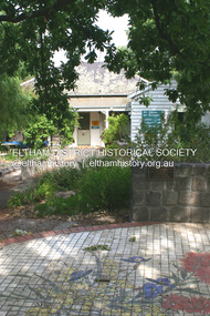 Eltham District Historical Society Inc
Photograph - Digital Photograph, Alan King, Eltham Living and Learning Centre, 26 January 2008
... changes. Claire, a journalist and community campaigner, modified and built pens for goats and poultry, a stable, a garage and planted fruit trees and a vegetable garden. ...changes. Claire, a journalist and community campaigner, modified and built pens for goats and poultry, a stable, a garage and planted fruit trees and a vegetable garden. ...In 1857, tanner John Pearson purchased three and a half acres of land in Little Eltham, at the western end of Pitt Street, with a 70-foot frontage to Maria Street (Main Road) and stretching down to the Diamond Creek for £100. He contracted Benjamin Oliver Wallis to build house for him. Wallis, a mason by trade who originated from the Cornish village of Newlyn, migrated to Melbourne in 1853 and was shortly engaged by Richard Warren to build the Eltham Hotel, which opened in 1854. When Warren fell into financial difficulty in 1858, Wallis purchased the hotel. That same year, Pearson constructed a tannery below the house with access to the water in the Diamond Creek. When Pearson became bankrupt in 1867, Wallis similarly acquired the house from Pearson’s creditors in 1868 and lived there until his death in 1896. For some of this time the house was in the name of Wallis’s son Richard but following his death in 1888, ownership reverted to his father. It was purchased by retired teacher Richard Gilsenen in 1899. Gilsenen was made acting head teacher at the Eltham State School in 1906 following the sudden death of head teacher John Brown. In the 1950s the house was bought by retired engineer Dr Alfred Fitzpatrick and his wife Claire who made various modifications to house goats and poultry as well as structural modifications to the house. In the early 1970s, Eltham Shire Councillors Frank Maas and Don Maling proposed an extended communities’ activities program be set up and the Commonwealth Grants Commission was approached for financial assistance. In 1974 a $50,000 Commonwealth Grant was received by the Shire Council to acquire the Fitzpatrick property as part of the planning to establish an extended communities’ activities program. The Fitzpatricks moved next door and Claire taught at the new Living and Learning Centre, which began in 1975, one of the first community education centres in Victoria. Covered under Heritage Overlay, Nillumbik Planning Scheme. Published: Nillumbik Now and Then / Marguerite Marshall 2008; photographs Alan King with Marguerite Marshall.; p59 It’s a centre for sharing knowledge and friendship and it stands on the former hub of Eltham’s original township near Pitt Street. The Eltham Living and Learning Centre, with around 2000 participants a year, began in 1975 as one of the first Community Education Centres in Victoria. Classes ranging from macramé to wine making to environmental living have enriched the lives of thousands of people through the generosity of tutors sharing their skills free of charge. The centre’s heart is the brick cottage, built in 1858 by tanner John Pearson. He bought the three and a half acre (1.4ha) allotment fronting Maria Street (now Main Road) and stretching down to the Diamond Creek. The allotment formed part of a 316 acre (127.8ha) subdivision, owned by Josiah Holloway, called Little Eltham, north of the original Eltham Reserve.1 The allotment then passed through the hands of several speculators before it was sold to Pearson for £100 in 1857. Mr Pearson’s children attended the Eltham Primary School from 1864 to 1867. But creditors took possession of the property when his tannery folded in 1867. It was then sold to publican Benjamin Wallis, who owned the Eltham Hotel at the corner of Pitt Street and Main Road. In 1899 the property was bought by Richard Gilsenan, who became acting head teacher of the Eltham Primary State School in 1906. In the 1950s, retired engineer Dr Alfred Fitzpatrick and his wife Claire bought the property, and made structural changes. Claire, a journalist and community campaigner, modified and built pens for goats and poultry, a stable, a garage and planted fruit trees and a vegetable garden. In the early 1970s a young woman called Carina Hack approached Gwen Wesson at the Diamond Valley Learning Centre (Victoria’s first Community Education Centre) about starting a community centre. Following Wesson’s suggestion, Hack spoke to Shire President Alistair Knox ‘one bleak rainy afternoon, sipping hot drinks and discussing life’.2 Eltham Shire Councillors Frank Maas and Don Maling proposed a community activities program and the council received a $50,000 Commonwealth Government Grant for this venture.3 The Fitzpatricks sold their property to the council and moved next door and Claire taught at the new centre, which Hack named. Eltham obviously wanted such a centre as Hack recalls. ‘During the next two months we had about 50 volunteers working day, night and weekends, scrubbing down, plastering and painting walls, replacing floors, repairing fences, recycling furniture, sewing curtains and cushions, donating furniture, toys, equipment, clean-ing and gardening…’4 The first enrolment day saw a queue stretching up the driveway nearly to the gate and the first sessions attracted 270 people a week. Soon the outbuildings were converted into pottery studios and a large workshop. From 1979 the Eltham Art and Craft Market was held in the centre’s grounds and the Friends of the Centre ran it from 1980. A former program coordinator, Margaret Johnson, remembers enrolment day in the late 1970s and 1980s, when hundreds of people would queue – and some even camped overnight! Overnighters were greeted in the morning with fresh tea and toast. Another tradition was The Enrolment Day Cake with Recipe, given to volunteers. ‘One happy Enrolment Day fell on February 14 and let’s just say that St Valentine found some willing participants, paying $2 for a kiss.’5 Meanwhile the participants’ children could play at the Council Eltham Lower Park house in Hohnes Road, later in Susan Street. But the centre has had difficulties too. In 1990 a fire destroyed the stable and the police suspected arson. However the pavilion was built in its place.This collection of almost 130 photos about places and people within the Shire of Nillumbik, an urban and rural municipality in Melbourne's north, contributes to an understanding of the history of the Shire. Published in 2008 immediately prior to the Black Saturday bushfires of February 7, 2009, it documents sites that were impacted, and in some cases destroyed by the fires. It includes photographs taken especially for the publication, creating a unique time capsule representing the Shire in the early 21st century. It remains the most recent comprehenesive publication devoted to the Shire's history connecting local residents to the past. nillumbik now and then (marshall-king) collection, benjamin oliver wallis, claire fitzpatrick, don maling, dr alfred fitzpatrick, eltham living and learning centre, frank maas, john pearson, richard gilsenen, tannery -
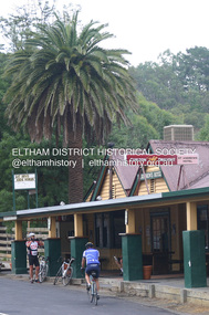 Eltham District Historical Society Inc
Photograph - Digital Photograph, Alan King, St Andrews Hotel, 2 February 2008
... tree is aesthetically and historically significant as a local landmark and for its contribution to the streetscape and landscape value. Covered under Heritage Overlay, Nillumbik Planning Scheme. Published: Nillumbik Now and Then / Marguerite Marshall 2008; photographs Alan King with Marguerite Marshall.; p71 Built around 1860, St Andrews Hotel has changed little since it first welcomed thirsty gold diggers from the Caledonia Goldfields. ...tree is aesthetically and historically significant as a local landmark and for its contribution to the streetscape and landscape value. Covered under Heritage Overlay, Nillumbik Planning Scheme. Published: Nillumbik Now and Then / Marguerite Marshall 2008; photographs Alan King with Marguerite Marshall.; p71 Built around 1860, St Andrews Hotel has changed little since it first welcomed thirsty gold diggers from the Caledonia Goldfields. ...The c1860 St Andrews Hotel, with the c1930 additions, and the Canary Island Palm, and the surrounding site to the title boundaries are historically, socially and aesthetically significant to the Shire of Nillumbik. The St Andrews Hotel is historically significant because it may have given its name 'St Andrews' to the town (another suggestion is that the name came from St Andrews church) and for its connection to Ewen Hugh Cameron (1831-1915) the prosperous local farmer, member of the Eltham Roads Board/Shire Council and local MP. It is also significant as the oldest hotel building in the former Shire of Eltham, as one of the few surviving buildings connected with the Caledonian goldfields era and as one of a handful of early structures to have survived the 1960s bushfires; the additions and alterations to the hotel reflect its long life. The hotel is socially significant because it has served as an important meeting place for more than 160 years. The Canary Island Palm is historically significant as a rare example of exotic tree planting in this rural area. The tree is aesthetically and historically significant as a local landmark and for its contribution to the streetscape and landscape value. Covered under Heritage Overlay, Nillumbik Planning Scheme. Published: Nillumbik Now and Then / Marguerite Marshall 2008; photographs Alan King with Marguerite Marshall.; p71 Built around 1860, St Andrews Hotel has changed little since it first welcomed thirsty gold diggers from the Caledonia Goldfields. The timber building, with gabled roof, beamed ceilings and a massive fireplace, is Nillumbik Shire’s oldest hotel and has always been an important community centre, particularly in its early days. Fortunately, the hotel and the near-by Canary Island Palm Tree, which is quite rare in this area, survived the 1960s bushfires, along with a few other early buildings. St Andrews (formerly Queenstown) was founded on gold, as were Panton Hill (formerly Kingstown), Research and Diamond Creek, from the mid-1850s to the 1860s. But by the early 20th century common use changed the name Queenstown to St Andrews, possibly after this hotel or after the church or the mining district.1 The Caledonia Diggings were probably named by Scottish settlers after the Roman name for Scotland, despite this land bearing little similarity to their homeland.2 Queenstown, which was proclaimed as a township in 1861, was the gold-mining centre on the Upper Diamond and in the 1850s had up to 600 European inhabitants and a small camp of Chinese on the flats along the creek. Queenstown was the administrative centre of the Upper Diamond with three hotels, a brewery and a slaughterhouse.3 It is unclear which hotel was the district’s first, as distinct from the earliest unlicensed grog shops, some of which operated in tents. John Corke Knell was one of eight unlicensed storekeepers supplying drink to miners at Caledonia in 1857, named by Sgt. McNamara of the Caledonia Police Station.4 In February 1859, Knell apparently bought most of the present hotel’s site at the first township land sales. As he was a local storekeeper, he might have first established a store there.5 Knell and his wife Eliza were early licensees of the St Andrews Hotel. The hotel had eight bedrooms – including three for public use – and the dining-room seated 30 people. It is thought they named the hotel St Andrews after Eliza’s hometown of St Andrews in Scotland. St Andrews Hotel was an important local centre in several ways. In the same building the Knells also operated a post office and general store. In 1867 Mrs Knell was appointed Deputy Registrar of Births and Deaths for Queenstown. The hotel was also used to hold inquests into people’s deaths when the police residence became too small.6 The hotel also became a fashionable destination at Christmas for parties from Melbourne. In 1868, possibly following her husband’s death, Mrs Knell applied for a temporary licence, which was then transferred to Robert Smith after their marriage in 1869. But then, possibly after Robert’s death, Mrs Smith operated the hotel until 1892. This contradicts a report in The Evelyn Observer 1882 that JC Knells of the St Andrews Hotel was granted a publican’s licence in the Queenstown Police Court. At that time he was supposed to have been dead for around 14 years! Although Mrs Smith was a respected citizen, known for her geniality and as an ideal hostess, she had a minor brush with the law when she was fined ten shillings for not lighting a lamp outside her licensed premises.7 From 1892 several publicans owned the hotel including W Atkins, from 1895. In 1909 the licensee was apparently Mrs Smith’s son, Walter Knell, who held the licence until at least the 1920s. Not surprisingly, this old hotel has attracted romantic stories. Mrs Smith is said to be seen roaming the pub in her nightdress – even though she was buried in the Queenstown Cemetery in 1911.8 A musical The Hero of Queenstown, set in the hotel, was written and produced by local actor Reg Evans in the 1970s.This collection of almost 130 photos about places and people within the Shire of Nillumbik, an urban and rural municipality in Melbourne's north, contributes to an understanding of the history of the Shire. Published in 2008 immediately prior to the Black Saturday bushfires of February 7, 2009, it documents sites that were impacted, and in some cases destroyed by the fires. It includes photographs taken especially for the publication, creating a unique time capsule representing the Shire in the early 21st century. It remains the most recent comprehenesive publication devoted to the Shire's history connecting local residents to the past. nillumbik now and then (marshall-king) collection, st andrews hotel -
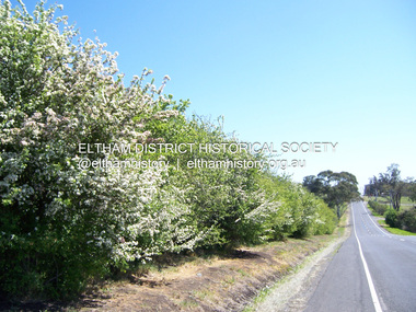 Eltham District Historical Society Inc
Photograph - Digital Photograph, Marguerite Marshall, Hawthorn hedges, Eltham-Yarra Glen Road, Kangaroo Ground, 3 October 2006
... trees’ to hunt kangaroos. The hawthorn hedges in Kangaroo Ground were neglected for around 60 years from about the middle of the 20th century. Bushfires had created gaps and the hedgerows were not trimmed. Then in late 2005, local historian Mick Woiwod, formed a group to lobby the Nillumbik Shire to restore the hedges, which could last for many centuries. Some hedges in parts of Britain date back to AD 800.5 Although the original Scottish farmers have gone, the hedges are a reminder of when they flourished in the district, which has changed...trees’ to hunt kangaroos. The hawthorn hedges in Kangaroo Ground were neglected for around 60 years from about the middle of the 20th century. Bushfires had created gaps and the hedgerows were not trimmed. Then in late 2005, local historian Mick Woiwod, formed a group to lobby the Nillumbik Shire to restore the hedges, which could last for many centuries. Some hedges in parts of Britain date back to AD 800.5 Although the original Scottish farmers have gone, the hedges are a reminder of when they flourished in the district, which has changed ...Hawthorn hedges are important reminders of Kangaroo Ground's Scottish heritage. They are Registered on the Victorian Heritage Register. They are "historically significant because the planting of hawthorn hedges reflects the adoption of Eurorpean farming techniques by the Kangaroo Ground population in the period following settlement and because the grid pattern of paddocks that the Hawthorn hedges define is very different to today's farm landscapes." Covered under Heritage Overlay, Nillumbik Planning Scheme. Published: Nillumbik Now and Then / Marguerite Marshall 2008; photographs Alan King with Marguerite Marshall.; p21 Hawthorn hedges bordering Kangaroo Ground’s gently rolling farmlands are important reminders of its Scottish heritage and are rare so close to Melbourne.1 As early as the 1840s newly arrived farmers from Scotland planted hawthorn hedges around their properties, to protect crops from the numerous kangaroos and wallabies. Many of these hedges survive today. These farmers had the good fortune to settle some of the most fertile land available for cropping in the Colony of Victoria. At that time the black volcanic soil could sustain an amazing two crops a year. By the mid 1850s, 500 acres (202ha) of wheat were growing in Kangaroo Ground. But the crops were threatened by kangaroos, which were so plentiful, that Surveyor-General, Robert Hoddle, named the district Kangaroo Ground in 1838. As post-and-rail fences proved inadequate barriers for the bounding kangaroos, the Scots planted hawthorn hedgerows as they had done in Scotland. Some also used the hedges to net birds, presumably for the table. Interestingly the farmers in the bordering townships of Panton Hill and Christmas Hills, did not plant hawthorn hedges around their properties. Perhaps it was because by the time they settled in the 1860s and 1870s most of the wildlife had been gunned down by residents.2 The canny Scots planted the hedges on public land outside their own farms, as the hedgerows could spread to about five yards (five m) in width. With this impenetrable barrier Kangaroo Ground’s industrious farmers flourished to gain the economic power that saw the Shire of Eltham governed from Kangaroo Ground for 79 years (1858-1937). The Scots jealously guarded their land, so hard to get in Scotland. That is why they refused to release any of it ‘for local roads to follow easier grades as was the case in surrounding districts where roads generally followed ridgelines or streams’.3 Instead the roads were built in accordance with the magnetic bearings of their first survey in 1847 whether that suited the steep topography or not. This could force traffic to diverge when wet through Greensborough and Diamond Creek. Until 1921, the Eltham-Yarra Glen Road beside Wellers Restaurant, ‘dipped down into the upper reaches of Stony Creek’.4 Later some corners were compulsorily cut for the increasing motor traffic. As late as the 1960s, corners were cut to form sweeping curves above and alongside the Kangaroo Ground Cemetery and opposite the Emergency Operations Centre. In the latter case, the farmers – understanding their hedgerows as important heritage – insisted upon their reinstatement to conform to the altered road alignment. Kangaroo Ground’s ancient manna gums also point to the district’s history and to that of the hedgerows. The Aboriginal people had transformed the original forests into grasslands with the fires they lit to attract kangaroos, (which the Scots were to exclude by planting hedgerows). But the Wurundjeri hunters left the gums (Eucalyptus vimminalis cygnetensis), on the grasslands as ‘stalking trees’ to hunt kangaroos. The hawthorn hedges in Kangaroo Ground were neglected for around 60 years from about the middle of the 20th century. Bushfires had created gaps and the hedgerows were not trimmed. Then in late 2005, local historian Mick Woiwod, formed a group to lobby the Nillumbik Shire to restore the hedges, which could last for many centuries. Some hedges in parts of Britain date back to AD 800.5 Although the original Scottish farmers have gone, the hedges are a reminder of when they flourished in the district, which has changed little in 150 years.This collection of almost 130 photos about places and people within the Shire of Nillumbik, an urban and rural municipality in Melbourne's north, contributes to an understanding of the history of the Shire. Published in 2008 immediately prior to the Black Saturday bushfires of February 7, 2009, it documents sites that were impacted, and in some cases destroyed by the fires. It includes photographs taken especially for the publication, creating a unique time capsule representing the Shire in the early 21st century. It remains the most recent comprehenesive publication devoted to the Shire's history connecting local residents to the past. nillumbik now and then (marshall-king) collection, eltham-yarra glen road, hawthorn hedgerow, kangaroo ground -
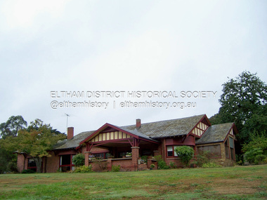 Eltham District Historical Society Inc
Photograph - Digital Photograph, Marguerite Marshall, 'Worlingworth', 10-26 Banoon Road, Eltham, 30 January 2006
... It is also one of the few substantial residences built in the Eltham Shire from the late 19th century to the early 20th century, which signalled a major change in the area towards the residential municipality it is today.3 The original section, built in the mid 1860s, of rose pink hand-made bricks and stone quarried on the property, was incorporated in the new red-brick house built in 1922. An immense oak tree...It is also one of the few substantial residences built in the Eltham Shire from the late 19th century to the early 20th century, which signalled a major change in the area towards the residential municipality it is today.3 The original section, built in the mid 1860s, of rose pink hand-made bricks and stone quarried on the property, was incorporated in the new red-brick house built in 1922. An immense oak tree ...'Worlingworth', Eltham, home of noted anthropologist the late Professor Donald Thomson and his wife Dorita Thomson. Covered under Heritage Overlay, Nillumbik Planning Scheme. Published: Nillumbik Now and Then / Marguerite Marshall 2008; photographs Alan King with Marguerite Marshall.; p127 Dubbed as ‘Australia’s Lawrence of Arabia’ anthropologist Donald Thomson lived much of his life in Eltham, at Banoon Road. On his retirement as Professor of Anthropology in 1968, The University of Melbourne professorial board compared Thomson to Lawrence of Arabia because of his work for Aborigines and his controversial personality. Although Thomson is now recognised for his huge contribution, during his lifetime he suffered opposition and his life has been described as ‘tragic’.1 Thomson failed to gain the recognition as a scientist that he felt he deserved and he failed to alter government policy towards Aboriginal people. But towards the end of his life in 1970, anthropologists were moving towards the type of research he had done and the movement to grant land rights to Aborigines was strengthening. Thomson is best known for his anthropological fieldwork in Cape York, Arnhem Land and Central Australia, but he is also known for his scholarly contributions to ornithology and ecology. Thomson documented every aspect of the daily and ritual life of the Aboriginal world of Cape York and Arnhem Land in the 1930s and 1940s. The huge collection in Museum Victoria includes 11,000 photographs, 7500 items of material culture, 1000 botanical and zoological specimens and 4500 pages of field-notes.2 The film Ten Canoes used Thomson’s photographs as a source. Thomson bought the Eltham property known as Worlingworth in 1934. The single-storey 60-square house standing by the Yarra River was built in 1922-23. It is one of the last in Eltham to survive with its farm setting intact. It is also one of the few substantial residences built in the Eltham Shire from the late 19th century to the early 20th century, which signalled a major change in the area towards the residential municipality it is today.3 The original section, built in the mid 1860s, of rose pink hand-made bricks and stone quarried on the property, was incorporated in the new red-brick house built in 1922. An immense oak tree by the house grew from an acorn brought by Patrick Armstrong who first bought the land in March 14, 1862. Armstrong named Worlingworth after his forbears’ village in Suffolk, England. Worlingworth saw grand days when Commander Alan A Barlee (R.N.) bought it in 1922 after winning the Calcutta Sweep. The property then included a nine-hole golf course, a tennis court, a bowling green, a boathouse and a boat-ramp.4 For most of his career Thomson, who was born in 1901, was attached to The University of Melbourne. In 1935 he represented the Commonwealth Government at Caledon Bay in east Arnhem Land to investigate and mediate for four Aborigines accused of killing five Japanese and three Europeans. In 1938 Thomson was awarded a PhD in Anthropology at Cambridge University, and during his career, he received several medals from British Societies, who perhaps appreciated his work better than their Australian counterparts. From World War Two, Thomson suffered a string of hardships, beginning with severe wounding in Dutch New Guinea (for his military service in New Guinea he was awarded an OBE) and he was invalided from service in 1944. That year he was diagnosed with diabetes. A fire in 1946 destroyed what Thomson regarded as perhaps the best record he had made of Aboriginal life – the 20,000 feet, (6096m) of film he had shot in Arnhem Land. In 1954 he and wife, Gladys, divorced. The next year he married his technical assistant, Dorita McColl. Several times during his career Thomson had major disagreements. For instance Professor P Elkin constantly opposed his work. He also opposed Thomson when he campaigned vigorously in 1947 against the establishment of a rocket range at Woomera, South Australia, because of the threat it posed Aborigines. Thomson resigned in frustration from the Victorian Aborigines Welfare Board in 1967, after serving for ten years, because he found that his advice was disregarded. His ashes were scattered over Caledon Bay from the air.This collection of almost 130 photos about places and people within the Shire of Nillumbik, an urban and rural municipality in Melbourne's north, contributes to an understanding of the history of the Shire. Published in 2008 immediately prior to the Black Saturday bushfires of February 7, 2009, it documents sites that were impacted, and in some cases destroyed by the fires. It includes photographs taken especially for the publication, creating a unique time capsule representing the Shire in the early 21st century. It remains the most recent comprehenesive publication devoted to the Shire's history connecting local residents to the past. nillumbik now and then (marshall-king) collection, banoon road, donald thomson, dorita thomson, eltham, worlingworth -
 Glen Eira Historical Society
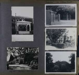
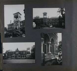
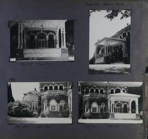
Album - Album page, Ripponlea, 192 Hotham Street, Circa 1972
... changed the interior and exterior during the ownerships of Benjamin Nathan and later his daughter Mrs Louisa Jones in the 1930s and are in their own right of significance. Sir Thomas Bent owned the property from 1903 until 1911 but never lived there. He subdivided much of the land. The original garden dates from about 1868, and it seems that William Guilfoyle of the Botanic Gardens was involved. It was redesigned in a more natural style in the 1880s by Sargood and his head gardener, Adam Anderson. The lake, waterfalls, fernery, hill and grotto are balanced by mighty deciduous trees ...This photograph is part of the Caulfield Historical Album 1972. This album was created in approximately 1972 as part of a project by the Caulfield Historical Society to assist in identifying buildings worthy of preservation. The album is related to a Survey the Caulfield Historical Society developed in collaboration with the National Trust of Australia (Victoria) and Caulfield City Council to identify historic buildings within the City of Caulfield that warranted the protection of a National Trust Classification. Principal photographer thought to be Trevor Hart, member of Caulfield Historical Society. Most photographs were taken between 1966-1972 with a small number of photographs being older and from unknown sources. All photographs are black and white except where stated, with 386 photographs over 198 pages.From Victorian Heritage Database citation for Rippon Lea H0614 https://vhd.heritagecouncil.vic.gov.au/places/427(as at 23/10/2020) Rippon Lea was commenced in 1868 by Frederick Sargood, a most successful politician and merchant. He was born in England in 1834 and arrived in Melbourne in 1850. He soon joined his father's wholesale soft goods firm, spending some time as its manager on the goldfields. Sargood entered the Legislative Council in 1874. He was Victoria's first Minister for Defence in 1883. Sir Frederick Sargood was created CMG. In 1885 and KCMG in 1890 as a reward for his contribution to public life. He died suddenly in 1903. Rippon Lea was designed by the leading firm of architects, Reed and Barnes. Joseph Reed had travelled in Europe in 1863, including northern Italy. When he returned he introduced the use of polychromy. While not the first examples, Rippon Lea and the Independent Church in Collins Street were the best and set a fashion which became a distinctly Melbourne style, particularly used for houses and churches. Its popularity was possible because of the new availability of different coloured bricks. Reed's fine Lombardic Romanesque details soon became debased by others. As Sargood's family grew and his fortunes prospered, Rippon Lea was extended to include 33 rooms - a complete mansion. The cast iron porte cochere and the northern conservatory were added in 1897. The architects were Taylor and Fitts. The ballroom was added in 1882 and remodelled in 1889. Many alterations have changed the interior and exterior during the ownerships of Benjamin Nathan and later his daughter Mrs Louisa Jones in the 1930s and are in their own right of significance. Sir Thomas Bent owned the property from 1903 until 1911 but never lived there. He subdivided much of the land. The original garden dates from about 1868, and it seems that William Guilfoyle of the Botanic Gardens was involved. It was redesigned in a more natural style in the 1880s by Sargood and his head gardener, Adam Anderson. The lake, waterfalls, fernery, hill and grotto are balanced by mighty deciduous trees and conifers. These are interspersed with, but never dominated by Australian species such as eucalyptus and other exotics. The sinuous drive with its carefully prepared approach to the house is notable. The original vegetable gardens, orchard and outer paddocks no longer survive. The shade house is important as the largest known in Australia and possibly the world. Its curved plan and form of construction are particularly notable. It was built about 1884.Page 90 of Photograph Album with five photographs (one landscape and 4 portrait) of Ripponlea - two different views of the front entrance to the mansion, one of the front gates and two different views of the main residence.Handwritten: "Ripponlea" 192 Hotham Street [top right] / North [under top left photo] / Neg 255 Dec 1972 MAIN DRIVE [under bottom left photo] / Neg 238 8 OCT 1966 [under middle right photo] / 88 [bottom right]trevor hart, elsternwick, mansion, hotham street, frederick sargood, reed and barnes, cast iron porte cochere, conservatory, 1860's, 1890's, ballroom, 1880's, benjamin nathan, louisa jones, thomas bent, sir thomas bent, william guilfoyle, adam anderson, lake, grotto, shade house, portico, ripponlea, victorian, sir frederick sargood, architects, polychrome bricks, lombardic romanesque architectural style, rippon lea, taylor and fitts, land subdivisions, gardens, drives, vegetable gardens, orchards -
 Glen Eira Historical Society
Album - Album page, Ripponlea, 192 Hotham Street, Circa 1972
... changed the interior and exterior during the ownerships of Benjamin Nathan and later his daughter Mrs Louisa Jones in the 1930s and are in their own right of significance. Sir Thomas Bent owned the property from 1903 until 1911 but never lived there. He subdivided much of the land. The original garden dates from about 1868, and it seems that William Guilfoyle of the Botanic Gardens was involved. It was redesigned in a more natural style in the 1880s by Sargood and his head gardener, Adam Anderson. The lake, waterfalls, fernery, hill and grotto are balanced by mighty deciduous trees ...This photograph is part of the Caulfield Historical Album 1972. This album was created in approximately 1972 as part of a project by the Caulfield Historical Society to assist in identifying buildings worthy of preservation. The album is related to a Survey the Caulfield Historical Society developed in collaboration with the National Trust of Australia (Victoria) and Caulfield City Council to identify historic buildings within the City of Caulfield that warranted the protection of a National Trust Classification. Principal photographer thought to be Trevor Hart, member of Caulfield Historical Society. Most photographs were taken between 1966-1972 with a small number of photographs being older and from unknown sources. All photographs are black and white except where stated, with 386 photographs over 198 pages.From Victorian Heritage Database citation for Rippon Lea H0614 https://vhd.heritagecouncil.vic.gov.au/places/427(as at 23/10/2020) Rippon Lea was commenced in 1868 by Frederick Sargood, a most successful politician and merchant. He was born in England in 1834 and arrived in Melbourne in 1850. He soon joined his father's wholesale soft goods firm, spending some time as its manager on the goldfields. Sargood entered the Legislative Council in 1874. He was Victoria?s first Minister for Defence in 1883. Sir Frederick Sargood was created CMG. In 1885 and KCMG in 1890 as a reward for his contribution to public life. He died suddenly in 1903. Rippon Lea was designed by the leading firm of architects, Reed and Barnes. Joseph Reed had travelled in Europe in 1863, including northern Italy. When he returned he introduced the use of polychromy. While not the first examples, Rippon Lea and the Independent Church in Collins Street were the best and set a fashion which became a distinctly Melbourne style, particularly used for houses and churches. Its popularity was possible because of the new availability of different coloured bricks. Reed's fine Lombardic Romanesque details soon became debased by others. As Sargood's family grew and his fortunes prospered, Rippon Lea was extended to include 33 rooms - a complete mansion. The cast iron porte cochere and the northern conservatory were added in 1897. The architects were Taylor and Fitts. The ballroom was added in 1882 and remodelled in 1889. Many alterations have changed the interior and exterior during the ownerships of Benjamin Nathan and later his daughter Mrs Louisa Jones in the 1930s and are in their own right of significance. Sir Thomas Bent owned the property from 1903 until 1911 but never lived there. He subdivided much of the land. The original garden dates from about 1868, and it seems that William Guilfoyle of the Botanic Gardens was involved. It was redesigned in a more natural style in the 1880s by Sargood and his head gardener, Adam Anderson. The lake, waterfalls, fernery, hill and grotto are balanced by mighty deciduous trees and conifers. These are interspersed with, but never dominated by Australian species such as eucalyptus and other exotics. The sinuous drive with its carefully prepared approach to the house is notable. The original vegetable gardens, orchard and outer paddocks no longer survive. The shade house is important as the largest known in Australia and possibly the world. Its curved plan and form of construction are particularly notable. It was built about 1884.Page 91 of Photograph Album with four photographs (two portrait and two landscape) of various external views of Ripponlea.Handwritten: SOUTH [under top left photo] / SOUTH [under top right photo] / WEST [under bottom left photo] / 91 [bottom left]trevor hart, elsternwick, mansion, hotham street, frederick sargood, reed and barnes, cast iron porte cochere, conservatory, 1860's, 1890's, ballroom, 1880's, benjamin nathan, louisa jones, thomas bent, sir thomas bent, william guilfoyle, adam anderson, lake, grotto, shade house, portico, ripponlea, victorian, sir frederick sargood, architects, taylor and fitts, rippon lea, polychrome bricks, lombardic romanesque style -
 Glen Eira Historical Society
Album - Album page, Ripponlea, Hotham Street, Circa 1972
... changed the interior and exterior during the ownerships of Benjamin Nathan and later his daughter Mrs Louisa Jones in the 1930s and are in their own right of significance. Sir Thomas Bent owned the property from 1903 until 1911 but never lived there. He subdivided much of the land. The original garden dates from about 1868, and it seems that William Guilfoyle of the Botanic Gardens was involved. It was redesigned in a more natural style in the 1880s by Sargood and his head gardener, Adam Anderson. The lake, waterfalls, fernery, hill and grotto are balanced by mighty deciduous trees ...This photograph is part of the Caulfield Historical Album 1972. This album was created in approximately 1972 as part of a project by the Caulfield Historical Society to assist in identifying buildings worthy of preservation. The album is related to a Survey the Caulfield Historical Society developed in collaboration with the National Trust of Australia (Victoria) and Caulfield City Council to identify historic buildings within the City of Caulfield that warranted the protection of a National Trust Classification. Principal photographer thought to be Trevor Hart, member of Caulfield Historical Society. Most photographs were taken between 1966-1972 with a small number of photographs being older and from unknown sources. All photographs are black and white except where stated, with 386 photographs over 198 pages.From Victorian Heritage Database citation for Rippon Lea H0614 https://vhd.heritagecouncil.vic.gov.au/places/427(as at 23/10/2020) Rippon Lea was commenced in 1868 by Frederick Sargood, a most successful politician and merchant. He was born in England in 1834 and arrived in Melbourne in 1850. He soon joined his father's wholesale soft goods firm, spending some time as its manager on the goldfields. Sargood entered the Legislative Council in 1874. He was Victoria?s first Minister for Defence in 1883. Sir Frederick Sargood was created CMG. In 1885 and KCMG in 1890 as a reward for his contribution to public life. He died suddenly in 1903. Rippon Lea was designed by the leading firm of architects, Reed and Barnes. Joseph Reed had travelled in Europe in 1863, including northern Italy. When he returned he introduced the use of polychromy. While not the first examples, Rippon Lea and the Independent Church in Collins Street were the best and set a fashion which became a distinctly Melbourne style, particularly used for houses and churches. Its popularity was possible because of the new availability of different coloured bricks. Reed's fine Lombardic Romanesque details soon became debased by others. As Sargood's family grew and his fortunes prospered, Rippon Lea was extended to include 33 rooms - a complete mansion. The cast iron porte cochere and the northern conservatory were added in 1897. The architects were Taylor and Fitts. The ballroom was added in 1882 and remodelled in 1889. Many alterations have changed the interior and exterior during the ownerships of Benjamin Nathan and later his daughter Mrs Louisa Jones in the 1930s and are in their own right of significance. Sir Thomas Bent owned the property from 1903 until 1911 but never lived there. He subdivided much of the land. The original garden dates from about 1868, and it seems that William Guilfoyle of the Botanic Gardens was involved. It was redesigned in a more natural style in the 1880s by Sargood and his head gardener, Adam Anderson. The lake, waterfalls, fernery, hill and grotto are balanced by mighty deciduous trees and conifers. These are interspersed with, but never dominated by Australian species such as eucalyptus and other exotics. The sinuous drive with its carefully prepared approach to the house is notable. The original vegetable gardens, orchard and outer paddocks no longer survive. The shade house is important as the largest known in Australia and possibly the world. Its curved plan and form of construction are particularly notable. It was built about 1884.Page 92 of Photograph Album with four photographs (three landscape and one portrait) of Ripponlea - views of entrance and left front of mansion.Handwritten: "Ripponlea" Hotham Street [top right] / Neg 245 Dec 1972 [under top left photo] / Neg 246 Dec 1972 [under bottom left photo] / Neg 247 Dec 1972 [under bottom right photo] / 92 [bottom right]trevor hart, elsternwick, mansion, hotham street, frederick sargood, reed and barnes, lombardic, romanesque, cast iron porte cochere, conservatory, 1860's, 1890's, ballroom, 1880's, benjamin nathan, louisa jones, thomas bent, sir thomas bent, william guilfoyle, adam anderson, lake, grotto, shade house, portico, ripponlea, victorian, sir frederick sargood, architects, polychrome bricks, lombardic romanesque style, rippon lea, entrances -
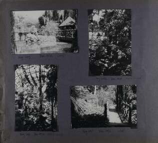 Glen Eira Historical Society
Album - Album page, Ripponlea, Hotham Street, Circa 1972
... changed the interior and exterior during the ownerships of Benjamin Nathan and later his daughter Mrs Louisa Jones in the 1930s and are in their own right of significance. Sir Thomas Bent owned the property from 1903 until 1911 but never lived there. He subdivided much of the land. The original garden dates from about 1868, and it seems that William Guilfoyle of the Botanic Gardens was involved. It was redesigned in a more natural style in the 1880s by Sargood and his head gardener, Adam Anderson. The lake, waterfalls, fernery, hill and grotto are balanced by mighty deciduous trees ...This photograph is part of the Caulfield Historical Album 1972. This album was created in approximately 1972 as part of a project by the Caulfield Historical Society to assist in identifying buildings worthy of preservation. The album is related to a Survey the Caulfield Historical Society developed in collaboration with the National Trust of Australia (Victoria) and Caulfield City Council to identify historic buildings within the City of Caulfield that warranted the protection of a National Trust Classification. Principal photographer thought to be Trevor Hart, member of Caulfield Historical Society. Most photographs were taken between 1966-1972 with a small number of photographs being older and from unknown sources. All photographs are black and white except where stated, with 386 photographs over 198 pages.From Victorian Heritage Database citation for Rippon Lea H0614 https://vhd.heritagecouncil.vic.gov.au/places/427(as at 23/10/2020) Rippon Lea was commenced in 1868 by Frederick Sargood, a most successful politician and merchant. He was born in England in 1834 and arrived in Melbourne in 1850. He soon joined his father's wholesale soft goods firm, spending some time as its manager on the goldfields. Sargood entered the Legislative Council in 1874. He was Victoria?s first Minister for Defence in 1883. Sir Frederick Sargood was created CMG. In 1885 and KCMG in 1890 as a reward for his contribution to public life. He died suddenly in 1903. Rippon Lea was designed by the leading firm of architects, Reed and Barnes. Joseph Reed had travelled in Europe in 1863, including northern Italy. When he returned he introduced the use of polychromy. While not the first examples, Rippon Lea and the Independent Church in Collins Street were the best and set a fashion which became a distinctly Melbourne style, particularly used for houses and churches. Its popularity was possible because of the new availability of different coloured bricks. Reed's fine Lombardic Romanesque details soon became debased by others. As Sargood's family grew and his fortunes prospered, Rippon Lea was extended to include 33 rooms - a complete mansion. The cast iron porte cochere and the northern conservatory were added in 1897. The architects were Taylor and Fitts. The ballroom was added in 1882 and remodelled in 1889. Many alterations have changed the interior and exterior during the ownerships of Benjamin Nathan and later his daughter Mrs Louisa Jones in the 1930s and are in their own right of significance. Sir Thomas Bent owned the property from 1903 until 1911 but never lived there. He subdivided much of the land. The original garden dates from about 1868, and it seems that William Guilfoyle of the Botanic Gardens was involved. It was redesigned in a more natural style in the 1880s by Sargood and his head gardener, Adam Anderson. The lake, waterfalls, fernery, hill and grotto are balanced by mighty deciduous trees and conifers. These are interspersed with, but never dominated by Australian species such as eucalyptus and other exotics. The sinuous drive with its carefully prepared approach to the house is notable. The original vegetable gardens, orchard and outer paddocks no longer survive. The shade house is important as the largest known in Australia and possibly the world. Its curved plan and form of construction are particularly notable. It was built about 1884.Page 93 of Photograph Album with four photographs (two landscape and two portrait) of Ripponlea - lake and gardens.Handwritten: Neg 239 Dec 1973 LAKE [under top left photo] / Neg 242 Dec 1973 FERN HOUSE [under top right photo] / Neg 243 Dec 1972 FERN HOUSE [under bottom left photo] / Neg 241 Dec 1972 LAKE [under bottom right photo] / 93 [bottom left]trevor hart, elsternwick, mansion, hotham street, frederick sargood, sargood, reed and barnes, 1860's, 1890's, 1880's, benjamin nathan, nathan, louisa jones, thomas bent, sir thomas bent, william guilfoyle, adam anderson, lake, grotto, shade house, portico, ripponlea, victorian, sir frederick sargood, architects, taylor and fitts, rippon lea, gardens, ferns, bridges, walking trails -
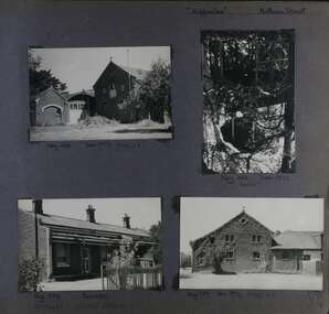 Glen Eira Historical Society
Album - Album page, "Ripponlea", Hotham Street, Circa 1972
... changed the interior and exterior during the ownerships of Benjamin Nathan and later his daughter Mrs Louisa Jones in the 1930s and are in their own right of significance. Sir Thomas Bent owned the property from 1903 until 1911 but never lived there. He subdivided much of the land. The original garden dates from about 1868, and it seems that William Guilfoyle of the Botanic Gardens was involved. It was redesigned in a more natural style in the 1880s by Sargood and his head gardener, Adam Anderson. The lake, waterfalls, fernery, hill and grotto are balanced by mighty deciduous trees ...This photograph is part of the Caulfield Historical Album 1972. This album was created in approximately 1972 as part of a project by the Caulfield Historical Society to assist in identifying buildings worthy of preservation. The album is related to a Survey the Caulfield Historical Society developed in collaboration with the National Trust of Australia (Victoria) and Caulfield City Council to identify historic buildings within the City of Caulfield that warranted the protection of a National Trust Classification. Principal photographer thought to be Trevor Hart, member of Caulfield Historical Society. Most photographs were taken between 1966-1972 with a small number of photographs being older and from unknown sources. All photographs are black and white except where stated, with 386 photographs over 198 pages.From Victorian Heritage Database citation for Rippon Lea H0614 https://vhd.heritagecouncil.vic.gov.au/places/427(as at 23/10/2020) Rippon Lea was commenced in 1868 by Frederick Sargood, a most successful politician and merchant. He was born in England in 1834 and arrived in Melbourne in 1850. He soon joined his father's wholesale soft goods firm, spending some time as its manager on the goldfields. Sargood entered the Legislative Council in 1874. He was Victoria?s first Minister for Defence in 1883. Sir Frederick Sargood was created CMG. In 1885 and KCMG in 1890 as a reward for his contribution to public life. He died suddenly in 1903. Rippon Lea was designed by the leading firm of architects, Reed and Barnes. Joseph Reed had travelled in Europe in 1863, including northern Italy. When he returned he introduced the use of polychromy. While not the first examples, Rippon Lea and the Independent Church in Collins Street were the best and set a fashion which became a distinctly Melbourne style, particularly used for houses and churches. Its popularity was possible because of the new availability of different coloured bricks. Reed's fine Lombardic Romanesque details soon became debased by others. As Sargood's family grew and his fortunes prospered, Rippon Lea was extended to include 33 rooms - a complete mansion. The cast iron porte cochere and the northern conservatory were added in 1897. The architects were Taylor and Fitts. The ballroom was added in 1882 and remodelled in 1889. Many alterations have changed the interior and exterior during the ownerships of Benjamin Nathan and later his daughter Mrs Louisa Jones in the 1930s and are in their own right of significance. Sir Thomas Bent owned the property from 1903 until 1911 but never lived there. He subdivided much of the land. The original garden dates from about 1868, and it seems that William Guilfoyle of the Botanic Gardens was involved. It was redesigned in a more natural style in the 1880s by Sargood and his head gardener, Adam Anderson. The lake, waterfalls, fernery, hill and grotto are balanced by mighty deciduous trees and conifers. These are interspersed with, but never dominated by Australian species such as eucalyptus and other exotics. The sinuous drive with its carefully prepared approach to the house is notable. The original vegetable gardens, orchard and outer paddocks no longer survive. The shade house is important as the largest known in Australia and possibly the world. Its curved plan and form of construction are particularly notable. It was built about 1884.Page 94 of Photograph Album with four photographs (three landscape and one portrait) of Ripponlea - stables, lookout and neighbouring cottages.Handwritten: "Ripponlea" Hotham Street [top right] / Neg 256 Dec 1972 STABLES [under top left photo] / Neg 248 Dec 1972 LOOKOUT [under top right photo] / Neg 254 Dec 1972 / COTTAGES WILLOW STREET [under bottom left photo] / Neg 259 Dec 1972 STABLES [under bottom right photo] / 94 [bottom right]trevor hart, elsternwick, mansion, hotham street, frederick sargood, reed and barnes, 1860's, 1890's, 1880's, benjamin nathan, nathan, louisa jones, thomas bent, sir thomas bent, william guilfoyle, guilfoyle, adam anderson, ripponlea, victorian, sir frederick sargood, architects, bricks, polychrome bricks, taylor and fitts, stables, lookouts, cottages, outbuildings, rippon lea -
 The Beechworth Burke Museum
Animal specimen - Brown Falcon, Trustees of the Australian Museum, 1860-1880
... trees or telephone poles which the bird can perch on. When frequenting towns located in the Australian Outback, these birds are reportedly quite tame and can be approached by humans. They may stay in the same location throughout the year or chose to move around locally in response to any changes in weather conditions. ...trees or telephone poles which the bird can perch on. When frequenting towns located in the Australian Outback, these birds are reportedly quite tame and can be approached by humans. They may stay in the same location throughout the year or chose to move around locally in response to any changes in weather conditions. ...The Brown Falcon is a small to medium bird of prey which can be found all throughout Australia. These birds are raptors and typically feed on mammals, birds, snakes, insects and rabbits. The Brown Falcon are located in all but the densest forests. They typically prefer to reside in locations of open grassland and agricultural areas which have scattered trees or telephone poles which the bird can perch on. When frequenting towns located in the Australian Outback, these birds are reportedly quite tame and can be approached by humans. They may stay in the same location throughout the year or chose to move around locally in response to any changes in weather conditions. This specimen is part of a collection of almost 200 animal specimens that were originally acquired as skins from various institutions across Australia, including the Australian Museum in Sydney and the National Museum of Victoria (known as Museums Victoria since 1983), as well as individuals such as amateur anthropologist Reynell Eveleigh Johns between 1860-1880. These skins were then mounted by members of the Burke Museum Committee and put-on display in the formal space of the Museum’s original exhibition hall where they continue to be on display. This display of taxidermy mounts initially served to instruct visitors to the Burke Museum of the natural world around them, today it serves as an insight into the collecting habits of the 19th centuryThis specimen is part of a significant and rare taxidermy mount collection in the Burke Museum. This collection is scientifically and culturally important for reminding us of how science continues to shape our understanding of the modern world. They demonstrate a capacity to hold evidence of how Australia’s fauna history existed in the past and are potentially important for future environmental research. This collection continues to be on display in the Museum and has become a key part to interpreting the collecting habits of the 19th century.The Brown Falcon specimen has plumage which is mostly brown and intermixed with white. This provides the appearance of having spotted colouring on the birds back. The head is also mostly brown with white under the beak area and a characteristic brown streak under the eye area. The eye is made from dark coloured glass.3 / Brown Hawk / See Catalogue, page 2 / taxidermy mount, taxidermy, animalia, burke museum, beechworth, australian museum, skin, reynell eveleigh johns, bird, brown falcon, falconidae -
 The Beechworth Burke Museum
Photograph, 2000
... The image is also useful for prompting discussion about how Beechworth has changed over time, with the photograph taken 78 years after the school closed down. beechworth burke museum school education trees nature state school woolshed gold mining teachers over time Owens and Murray advertiser public meetings public dance c. o'donoghue spring creek state governor Sir Reginald Talbot miners honour roll world war 1 Woolshed State. / School site / 2000 / - remnant trees / / co A colour rectangular photograph printed on glossy photographic paper. ...Woolshed is a small area about five kilometres north west of Beechworth, and almost about 225km north east of Melbourne. When gold was discovered at the nearby Spring Creek in February 1852, Woolshed was one of three settlements set up to house miners and their families. At its peak in 1857, Woolshed was also populated by 29 storekeepers and 14 hotels, as well as the Woolshed State School, which stood near where this photograph was taken. The school often played host to public meetings, as well as a public dance in 1897. The school was subject to some controversy in 1874 when one parent complained about the head of the school in the local newspaper, the Owens and Murray Advertiser, and at least three letters to the editor were exchanged between the two. According to the parent, C. O'Donoghue was not providing enough amusement for the children and was disrespectful to parents and staff. When the State Governor, Sir Reginald Talbot, visited Beechworth in 1906, the school organised a celebratory welcome. The Woolshed State School was ultimately closed in 1922 as miners had exhausted the Spring Creek gold supply and were moving elsewhere. This photograph, taken in about 2000, shows the trees that grew on or near the site of the original school. The Woolshed State School Honour Roll, with a list of the men from the school who served in the First World War, also still exists. It is stored in the Beechworth RSL as of 2015.This photograph is significant for its connection to an important site in Beechworth's gold mining history. Woolshed served a significant community of miners, with a population of at least 138 according to the 1911 census, with families that needed the school site to ensure their children's education. The image is also useful for prompting discussion about how Beechworth has changed over time, with the photograph taken 78 years after the school closed down.A colour rectangular photograph printed on glossy photographic paper.Woolshed State. / School site / 2000 / - remnant trees / / cobeechworth, burke museum, school, education, trees, nature, state school, woolshed, gold mining, teachers, over time, owens and murray advertiser, public meetings, public dance, c. o'donoghue, spring creek, state governor, sir reginald talbot, miners, honour roll, world war 1 -
 The Beechworth Burke Museum
Photograph, c. 1900
... trees. The group is participating in a nature study. Nature study was a new subject introduced into the school curriculum throughout the English-speaking world in the 1890s and 1900s that taught students about the natural environment. It was hoped that a concern about the natural environment would be fostered into the school children, who were seen as future citizens of the world, and that they would implement changes to preserve the natural environment when they reached adulthood. entertainment album beechworth burke museum nature study Reverse: 6953 (in pencil)/ ©/ DONALD HAYES/ BEECHWORTH (stamped in orange ink) Black and white rectangular reproduced photograph printed on matte photographic paper Photograph Photograph ...Taken in c. 1900, depicted is a group of adults and children dressed in formal attire standing and sitting on a granite outcrop that overlooks a valley surrounded by a cluster of eucalyptus trees. The group is participating in a nature study.Nature study was a new subject introduced into the school curriculum throughout the English-speaking world in the 1890s and 1900s that taught students about the natural environment. It was hoped that a concern about the natural environment would be fostered into the school children, who were seen as future citizens of the world, and that they would implement changes to preserve the natural environment when they reached adulthood.Black and white rectangular reproduced photograph printed on matte photographic paperReverse: 6953 (in pencil)/ ©/ DONALD HAYES/ BEECHWORTH (stamped in orange ink)entertainment album, beechworth, burke museum, nature study