Showing 109 items matching "underground mine map"
-
 Rutherglen Historical Society
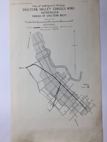
Map, 1908
... ...Underground Mine Map...Mining map of one of the first mines in Rutherglen area ( Chiltern West) Gold Rutherglen Mining Chiltern Underground Mine Map Geological Survey Reef Drives Geographical Survey of Victoria, Memoir, No6. ...This is a map produced as part of a book entitled.. It is also stamped on the back in blue ink with an oval ring and the words North of England Institute. Newcastle. Mining & Meterolgical Faculty. Purchased on 23rd July 2017 by the Society after research by member Simon Killeen. Mining map of one of the first mines in Rutherglen area ( Chiltern West)Cream paper, black printing, rectangle with a drawingGeographical Survey of Victoria, Memoir, No6. Plate XX Plan of Underground Workings CHILTERN VALLEY CONSOLS MINE, RUTHERGLEN, PARISH OF CHILTERN WESTgold, rutherglen, mining, chiltern, underground mine map, geological survey, reef drives -
 Federation University Historical Collection
Book, Mining Engineers Handbook Volume 1 & 2, 1941
... Maroon hardcovered books. .1) Volume 1 - Chapters include Mineralogy, Geology and Mineral Deposits, Earth Excavation, Explosives, Rock Excavation, Tunneling, Shaft Sinking in Rock, Shaft sinking in Unstable and Waterbearing Ground, Boring, Underground Transport, Mine Ventilation. .2) Volume 2 - Chapers include Compressed Air Practice, Electric Power for mine Service, Surveying,Underground Surveying, Mine Geologic Maps and models, Cost of mining, Mining Laws, Ore sampling, Assaying, Aerial Tramways and Cableways, Gold Amalgamation and Cyanidation, etc....Robert Peele was Professor Emeritus of mining Engineering at the School of Mines, Columbia University. charles bacon mining engineering mining engineering university of nevada mackay school of mines explosives timbering Inside front cover "Charles Bacon" Maroon hardcovered books. .1) Volume 1 - Chapters include Mineralogy, Geology and Mineral Deposits, Earth Excavation, Explosives, Rock Excavation, Tunneling, Shaft Sinking in Rock, Shaft sinking in Unstable and Waterbearing Ground, Boring, Underground Transport, Mine Ventilation. .2) Volume 2 - Chapers include Compressed Air Practice, Electric Power for mine Service, Surveying,Underground Surveying, Mine Geologic Maps and models, Cost of mining, Mining Laws, Ore sampling, Assaying, Aerial Tramways and Cableways, Gold Amalgamation and Cyanidation, etc. ...The book was used by Charles Bacon who studied at the University of Nevada in the late 1930s/early 1940s. Bacon worked at Bunker Hill Mines and Kellogg Idaho, before arriving in Australian in 1951. He worked for CN Myers, a company involved with paper converting. CN Myers was a family business (on Charles Bacon's maternal line). Robert Peele was Professor Emeritus of mining Engineering at the School of Mines, Columbia University.Maroon hardcovered books. .1) Volume 1 - Chapters include Mineralogy, Geology and Mineral Deposits, Earth Excavation, Explosives, Rock Excavation, Tunneling, Shaft Sinking in Rock, Shaft sinking in Unstable and Waterbearing Ground, Boring, Underground Transport, Mine Ventilation. .2) Volume 2 - Chapers include Compressed Air Practice, Electric Power for mine Service, Surveying,Underground Surveying, Mine Geologic Maps and models, Cost of mining, Mining Laws, Ore sampling, Assaying, Aerial Tramways and Cableways, Gold Amalgamation and Cyanidation, etc.Inside front cover "Charles Bacon"charles bacon, mining engineering, mining, engineering, university of nevada, mackay school of mines, explosives, timbering -
 Kiewa Valley Historical Society
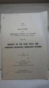
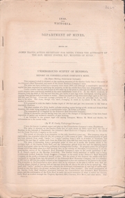
Document - Four Geological reports on the North-east Goldfields, Geological Survey of Victoria 1958 Bulletin
... mines and tunnels. A resurvey of goldfields was necessary to re-assess economic possibilities using modern techniques and structural interpretation. It included an examination of a considerable surface area with maps and underground workings. ...mines and tunnels. A resurvey of goldfields was necessary to re-assess economic possibilities using modern techniques and structural interpretation. It included an examination of a considerable surface area with maps and underground workings. ...Geological Surveys of N.E. Goldfields Victoria included mines and tunnels. A resurvey of goldfields was necessary to re-assess economic possibilities using modern techniques and structural interpretation. It included an examination of a considerable surface area with maps and underground workings. Results were correlated and integrated and published by the Mines Department.The mines are in the Bogong Alpine Area.Foolscap printed Victorian Bulletins. Each stapled in the top left corner and each with varying number of pages. Covering 1941-1958 a) Glen Wills and Sunnyside b) Sunnyside Tunnel c) Red Robin d) Maud and Yellow Girl Government Printer, Mines Department, Melbourne, Victoriageology in the north-east, gold fields, goldmines, glen wills -
 Bendigo Historical Society Inc.
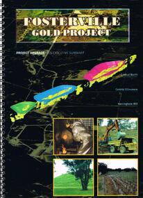
Document - FOSTERVILLE GOLD MINE COLLECTION: FOSTERVILLE GOLD PROJECT UPGRADE EXECUTIVE SUMMARUY
... Map of ore body on cover - Central North, Central Ellesmere, Harringtons Hill. Contents include: open pits, heap leaching, waste dumps, estimated project life, changes from previously approved project, estimated project life, main project components, expanded open pits and underground mines, processing sulphide ore, tailings storages, waste rock dumps. ...Mine Black cover book, wire binding, 13 pages of text and maps. On front: Fosterville Gold Project' Map of ore body on cover - Central North, Central Ellesmere, Harringtons Hill. Contents include: open pits, heap leaching, waste dumps, estimated project life, changes from previously approved project, estimated project life, main project components, expanded open pits and underground mines, processing sulphide ore, tailings storages, waste rock dumps. ...Black cover book, wire binding, 13 pages of text and maps. On front: Fosterville Gold Project' Map of ore body on cover - Central North, Central Ellesmere, Harringtons Hill. Contents include: open pits, heap leaching, waste dumps, estimated project life, changes from previously approved project, estimated project life, main project components, expanded open pits and underground mines, processing sulphide ore, tailings storages, waste rock dumps. Principles of rehabilitation, site preparation, rehabilitation activities during operation and decommissioning activities. Environmental issues, and summary of proposed new operating conditions.bendigo, mining, fosterville gold mine -
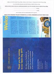 Bendigo Historical Society Inc.
Document - FOSTERVILLE GOLD MINE COLLECTION: OPEN DAY 2019
... Open Day activities include: bus tours, technical services display, geology, exploration, processing, community and environment display, minerals council of Australia, Swick drilling, Central Deborah Gold Mine, Face painting, Goldfields Re-vegetation, Delecca's hire equipment, MacMahon underground mining services, Sandvik, and ISH24 safety specialists. Map...Open Day activities include: bus tours, technical services display, geology, exploration, processing, community and environment display, minerals council of Australia, Swick drilling, Central Deborah Gold Mine, Face painting, Goldfields Re-vegetation, Delecca's hire equipment, MacMahon underground mining services, Sandvik, and ISH24 safety specialists. Map ...Two page document for Kirkland Lake Gold Open day 2019. Open Day activities include: bus tours, technical services display, geology, exploration, processing, community and environment display, minerals council of Australia, Swick drilling, Central Deborah Gold Mine, Face painting, Goldfields Re-vegetation, Delecca's hire equipment, MacMahon underground mining services, Sandvik, and ISH24 safety specialists. Map of 'Fosterville Gold Mine Site Map' with activities highlighted. Fosterville is Victoria's larges gold producer and in 2918 a records 356,230 ounces at an average grade of 24.9 g per tonne. The mine has over 600 full time employees in 2019. Entry for '9 levels of darkness' tour at Central Deborah Mine attached.bendigo, mining, fosterville gold mine -
 Bendigo Historical Society Inc.
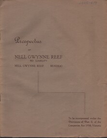
Document - MCCOLL, RANKIN AND STANISTREET COLLECTION: NELL GWYNNE REEF N/L - PROSPECTUS, 1938
... History House 11 Mackenzie Street Bendigo goldfields ORGANIZATION Business nell gwynne reef mine McColl Rankin & Stanistreet Nell Gwynne Reef N/L gold mining prospectus McColl, Rankin & Stanistreet Document. Slim, stapled Greybrown book. Nell Gwynne Reef N/L Prospectus. Contains underground maps ...Document. Slim, stapled Greybrown book. Nell Gwynne Reef N/L Prospectus. Contains underground maps.McColl, Rankin & Stanistreetorganization, business, nell gwynne reef mine, mccoll, rankin & stanistreet, nell gwynne reef n/l, gold mining, prospectus -
 Bendigo Historical Society Inc.
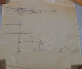
Plan - Mine Map
... History House 11 Mackenzie Street Bendigo goldfields Bendigo Margaret Roberts gold Map Mine Margaret Roberts Collection Transverse section of un-named mine showing underground workings and geological features. ...Transverse section of un-named mine showing underground workings and geological features. Forms part of the Margaret Roberts Collection of mining records.bendigo, margaret roberts, gold, map, mine, margaret roberts collection -
 Bendigo Historical Society Inc.
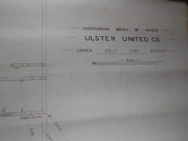
Plan - Ulster United Co
... Draftsman's drawing Underground Survey of Mines Ulster United Co. Garden Gully Line Bendigo Map. ...History House 11 Mackenzie Street Bendigo goldfields Bendigo Margaret Roberts gold Map Mine Ulster United Co Margaret Roberts Collection Draftsman's drawing Underground Survey of Mines Ulster United Co. ...Draftsman's drawing Underground Survey of Mines Ulster United Co. Garden Gully Line Bendigo Map. Forms part of the Margaret Roberts Collection of mining records.bendigo, margaret roberts, gold, map, mine, ulster united co, margaret roberts collection -
 Bendigo Historical Society Inc.
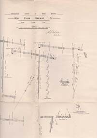
Document - UNDERGROUND SURVEY OF BENDIGO MINES
... Underground survey of Bendigo, report on Constellation Company's Mine on northern extension of the Garden Gully line of reef. Report on the New Chum Railway Reserve Company and the Shenandoah Company, the New Chum Railway Co being immediately south and the Shenandoah Co immediately north of the railway line. Two maps...History House 11 Mackenzie Street Bendigo goldfields BENDIGO Mining garden gully line of reef mines Jems Stirling, geologist and W.H Cundy Underground Surveyor, Department of Mines Two page document, 'Underground survey of Bendigo, report on Constellation Company's Mine on northern extension of the Garden Gully line of reef. Report on the New Chum Railway Reserve Company and the Shenandoah Company, the New Chum Railway Co being immediately south and the Shenandoah Co immediately north of the railway line. Two maps ...Two page document, 'Underground survey of Bendigo, report on Constellation Company's Mine on northern extension of the Garden Gully line of reef. Report on the New Chum Railway Reserve Company and the Shenandoah Company, the New Chum Railway Co being immediately south and the Shenandoah Co immediately north of the railway line. Two maps Constellation Co. Mine shaft and New Chum Railway and Shenandoah auriferous reef below 2700 feet.Jems Stirling, geologist and W.H Cundy Underground Surveyor, Department of Minesbendigo, mining, garden gully line of reef mines -
 Bendigo Historical Society Inc.
Document - MARKS COLLECTION: NEW CHUM LINE OF REEF MAP
... Underground survey of mines Sandhurst, New Chum Line of Reef', plan shows longitudinal and cross section views of the workings on the reef. Shaft No. 76 marked. Datum line on top indicates 750' above sea level, on bottom of plan, bottom of shaft 2022.24 below sill. Drawn by Arthur Everett, Mining Department, Melbourne, 1884. Document MARKS COLLECTION: NEW CHUM LINE OF REEF MAP ...Plan (copy) of New Chum Line of Reef. Plan has been copied in two sections. On top of plan 'Underground survey of mines Sandhurst, New Chum Line of Reef', plan shows longitudinal and cross section views of the workings on the reef. Shaft No. 76 marked. Datum line on top indicates 750' above sea level, on bottom of plan, bottom of shaft 2022.24 below sill. Drawn by Arthur Everett, Mining Department, Melbourne, 1884.bendigo, mining, new chum line of reef -
 Bendigo Historical Society Inc.
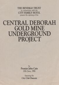
Book - JOAN O'SHEA COLLECTION: CENTRAL DEBORAH UNDERGOUND PROJECT, 20th June, 1986
... The Bendigo Trust in conjunction with the City Family Hotel present the opening of the Central Deborah Gold Mine Underground Project, by Premier John Cain, 20th June, 1986 featuring the City Club Dancers. Includes a brief chronological history of the mine and photographs courtesy of Phillip Beer on recto side. The verso side contains a map...The Bendigo Trust in conjunction with the City Family Hotel present the opening of the Central Deborah Gold Mine Underground Project, by Premier John Cain, 20th June, 1986 featuring the City Club Dancers. Includes a brief chronological history of the mine and photographs courtesy of Phillip Beer on recto side. The verso side contains a map ...Joan O'Shea Collection. Central Deborah Gold Mine Bendigo Violet Street (off High Street) Bendigo Pamphlet. Buff and Sepia double-sided A4. The Bendigo Trust in conjunction with the City Family Hotel present the opening of the Central Deborah Gold Mine Underground Project, by Premier John Cain, 20th June, 1986 featuring the City Club Dancers. Includes a brief chronological history of the mine and photographs courtesy of Phillip Beer on recto side. The verso side contains a map of the site of the Central Deborah Gold Mine and also various photographs with further detail of areas of interest including: poppet legs and shaft, the change rooms, caretakers or rag pickers room where clothing was searched, the drying room, the first aid room, carbide light room, underground tours, carpenters shed, ore bins and loading bays, stamper battery, wilfley table, berdan plans, laboratory, display room, boiler, stoke hold, winding engine, boiler feed pump, electric driven compressor, steam driven compressor and the blacksmith's shop.Central Deborah Gold Mine Bendigobendigo, gold mining, central deborah gold mine -
 Bendigo Historical Society Inc.
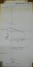
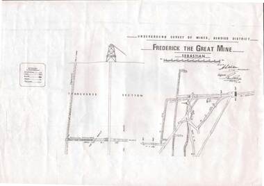
Map - STRUGNELL COLLECTION: UNDERGROUND SURVEY OF MINES, BENDIGO DISTRICT, 7-1-99
... Map, Underground Survey of Mines Bendigo District.Frederick the Great Mine, Sebastian. ...History House 11 Mackenzie Street Bendigo goldfields MAP Bendigo frederick the great mine A.S.Whitelaw Map, Underground Survey of Mines Bendigo District.Frederick the Great Mine, Sebastian. ...Map, Underground Survey of Mines Bendigo District.Frederick the Great Mine, Sebastian. A collection of nine (9) maps of the mine, Signed H.S.Whitelaw Field Geologist 4.1.99 with some notes relating to same, including a: * Typed overview of the operation of the mine in 1912. * Clipping from Victoria its Mines and Minerals detailing the operation of the mine from its beginning in 1863 where it was first worked for alluvial. Charlton & Co., and Mr. Glass mentioned in article.A.S.Whitelawmap, bendigo, frederick the great mine -
 Bendigo Historical Society Inc.
Map - STRUGNELL COLLECTION: UNDERGROUND SURVEY OF MINES, BENDIGO, 28-3-01
... Map, Underground Survey of Mines, Bendigo, Shamrock Co., New Chum Line. ...H.S.Whitelaw Map, Underground Survey of Mines, Bendigo, Shamrock Co., New Chum Line. ...Map, Underground Survey of Mines, Bendigo, Shamrock Co., New Chum Line. Surveyed under the Supervision of H.Herman. Signed H.S.Whitelaw 28.3.01H.S.Whitelawmap, bendigo, shamrock co. -
 Bendigo Historical Society Inc.
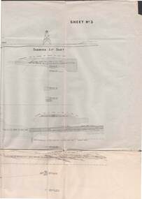
Map - STRUGNELL COLLECTION: UNDERGROUND SURVEY OF MINES BENDIGO
... Map, Underground Survey of Mines, Bendigo, New Chum Railway Reef, Shenandoah Co's Shaft, Shamrock Co's Shaft.Young Chum Reef, Thorpe's Reef, Shenandoah Reef, Consolidated Reef, Sheet 3.Survey under the Supervision of H.Herman. ...Drawing shows mine shafts to over 3100 feet deep Map STRUGNELL COLLECTION: UNDERGROUND SURVEY OF MINES BENDIGO ...Map, Underground Survey of Mines, Bendigo, New Chum Railway Reef, Shenandoah Co's Shaft, Shamrock Co's Shaft.Young Chum Reef, Thorpe's Reef, Shenandoah Reef, Consolidated Reef, Sheet 3.Survey under the Supervision of H.Herman. Drawing shows mine shafts to over 3100 feet deepmap, bendigo, shamrock & shenandoah co's -
 Bendigo Historical Society Inc.
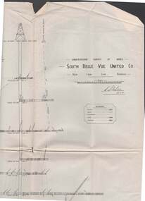
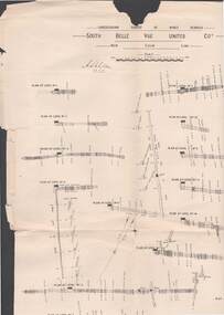
Map - STRUGNELL COLLECTION: UNDERGROUND SURVEY OF MINES, BENDIGO, 29-3-01
... Map, Underground Survey of Mines, Bendigo, South Belle Vue United Co.,New Chum Line.Transverse Section. ...H.S.Whitelaw Map, Underground Survey of Mines, Bendigo, South Belle Vue United Co.,New Chum Line.Transverse Section. ...Map, Underground Survey of Mines, Bendigo, South Belle Vue United Co.,New Chum Line.Transverse Section. Signed H.S.Whitelaw29.3.01 Drawing appears to show samples of connecting horizontal shafts with their respective mineral contentsH.S.Whitelawmap, bendigo, south belle vue united co.. -
 Bendigo Historical Society Inc.
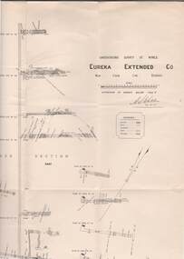
Map - STRUGNELL COLLECTION: UNDERGROUND SURVEY OF MINES, BENDIGO, 29-4-01
... Map, Underground Survey of Mines, Bendigo.Eureka Extended Co., New Chum Line. ...A>S>Whitelaw Map, Underground Survey of Mines, Bendigo.Eureka Extended Co., New Chum Line. ...Map, Underground Survey of Mines, Bendigo.Eureka Extended Co., New Chum Line. Signed H.A.Whitelaw 29.4.01 Drawing shows mine shaft from 1871 feet to over 3030 feet deep and appears to show samples of connecting horizontal shafts with their respective mineral contents.A>S>Whitelawmap, bendigo, eureka extended co. -
 Bendigo Historical Society Inc.
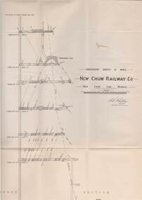
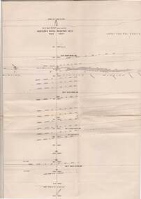
Map - STRUGNELL COLLECTION: UNDERGROUND SURVEY OF MINES, BENDIGO, 25-5-01
... Map, Underground Survey of Mines, Bendigo, New Chum Railway Co, New Chum Line....A.S.Whitelaw Map, Underground Survey of Mines, Bendigo, New Chum Railway Co, New Chum Line. ...Map, Underground Survey of Mines, Bendigo, New Chum Railway Co, New Chum Line.A.S.Whitelawmap, bendigo, new chum railway co. -
 Bendigo Historical Society Inc.
Map - STRUGNELL COLLECTION: UNDERGROUND SURVEY OF MINES, BENDIGO, 29-3-01
... Map, Underground Survey of Mines, New Chum Railway Co., New Chum Line, Transverse Section....A.S.Whitelaw Map, Underground Survey of Mines, New Chum Railway Co., New Chum Line, Transverse Section. ...Map, Underground Survey of Mines, New Chum Railway Co., New Chum Line, Transverse Section.A.S.Whitelawmap, bendigo, new chum railway co. -
 Bendigo Historical Society Inc.
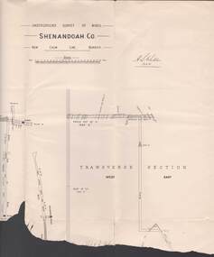
Map - STRUGNELL COLLECTION: UNDERGROUND SURVEY OF MINES, BENDIGO, 20-3-01
... Map, Underground Survey of Mines, Bendigo.Shenandoah Co., New Chum Line,...H.S.Whitelaw Map, Underground Survey of Mines, Bendigo.Shenandoah Co., New Chum Line, Map STRUGNELL COLLECTION: UNDERGROUND SURVEY OF MINES, BENDIGO. ...Map, Underground Survey of Mines, Bendigo.Shenandoah Co., New Chum Line,H.S.Whitelawmap, bendigo, shenandoah co. -
 Bendigo Historical Society Inc.
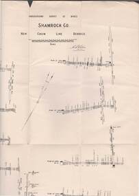
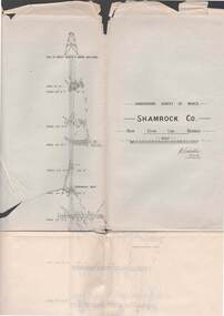
Map - STRUGNELL COLLECTION: UNDERGROUND SURVEY OF MINES BENDIGO, 27-3-01
... Map, Underground Survey of Mines, Shamrock Co., New Chum Line, Bendigo. ...H.S.Whitelaw. Map, Underground Survey of Mines, Shamrock Co., New Chum Line, Bendigo. ...Map, Underground Survey of Mines, Shamrock Co., New Chum Line, Bendigo. Transverse Section, Garibaldi Reef, Young Chum Reef, Thorpe's Reef, Mundic Reef, Shenandoah Reef, New Chum Railway Reef, Surveyed under the Supervision of H.Herman.H.S.Whitelaw.map, bendigo, shamrock co. -
 Bendigo Historical Society Inc.
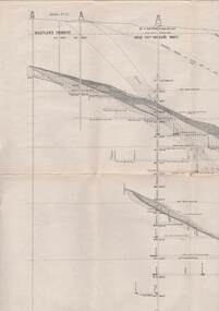
Map - STRUGNELL COLLECTION: UNDERGROUND SURVEY OF MINES BENDIGO, 25/05/01
... Map, Underground Survey of Mines, Bendigo, South Belle Vue United Coy, New Chum Line, Surveyed under the Supervision of H.Herman,B.C.E.,F.G.S.,Acting Government Geologist....Map STRUGNELL COLLECTION: UNDERGROUND SURVEY OF MINES BENDIGO ...Map, Underground Survey of Mines, Bendigo, South Belle Vue United Coy, New Chum Line, Surveyed under the Supervision of H.Herman,B.C.E.,F.G.S.,Acting Government Geologist.A.S.Whitelawmap, bendigo, belle vue united coy -
 Bendigo Historical Society Inc.
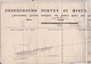
Map - STRUGNELL COLLECTION: NEW CHUM LINE OF REEF, 5/4/01
... Map, Along portion of the New Chum Line, Underground Survey of Mines, Bendigo, Longitudinal Section through the Saddle Reefs and Centre Country. ...History House 11 Mackenzie Street Bendigo goldfields MAP Bendigo new chum line H.S.Whitelow Map, Along portion of the New Chum Line, Underground Survey of Mines, Bendigo, Longitudinal Section through the Saddle Reefs and Centre Country. ...Map, Along portion of the New Chum Line, Underground Survey of Mines, Bendigo, Longitudinal Section through the Saddle Reefs and Centre Country. Eureka Extended Co's shaft, New Chum Railway Co's shaft. Surveyed under the supervision of H.Herman, B.C.E., F.G.S., Acting Government Geologist.H.S.Whitelowmap, bendigo, new chum line -
 Bendigo Historical Society Inc.
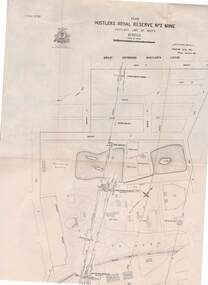
Map - STRUGNELL COLLECTION: HUSTLER'S Royal Reserve Shaft No. 2 Bendigo, September 1913
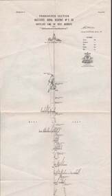
... Map, Hustler's Line of Reef, Hustler's Royal Reserves No. 2 Co, Longitudinal Section.Plate No.V111 (8). Bulletin No 33 Signed H.A.Whitelaw Underground survey Office Bendigo September 1913 Drawing shows mine shaft to over 1746 feet deep and appears to show samples of connecting horizontal shafts...History House 11 Mackenzie Street Bendigo goldfields MAP Bendigo hustler's royal reserve no. 2 mine* Underground Survey Office, Bendigo. ...Map, Hustler's Line of Reef, Hustler's Royal Reserves No. 2 Co, Longitudinal Section.Plate No.V111 (8). Bulletin No 33 Signed H.A.Whitelaw Underground survey Office Bendigo September 1913 Drawing shows mine shaft to over 1746 feet deep and appears to show samples of connecting horizontal shaftsUnderground Survey Office, Bendigo.map, bendigo, hustler's royal reserve no. 2 mine* -
 Bendigo Historical Society Inc.
Map - STRUGNELL COLLECTION: HUSTLER'S LINE OF REEFS, BENDIGO, September 1913
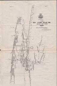
... Map, Hustler's Line of Reefs, Great Extended Hustler's Mine, Bendigo, Transverse Section. Plate No. X11 (12). Bulletin No 33 Signed H.A.Whitelaw Underground survey Office Bendigo September 1913 Drawing shows mine shaft to over 3454 feet deep and appears to show samples of connecting horizontal shafts with their respective mineral contents...History House 11 Mackenzie Street Bendigo goldfields MAP Bendigo great extended hustler's mine Underground Survey Office, Bendigo. ...Map, Hustler's Line of Reefs, Great Extended Hustler's Mine, Bendigo, Transverse Section. Plate No. X11 (12). Bulletin No 33 Signed H.A.Whitelaw Underground survey Office Bendigo September 1913 Drawing shows mine shaft to over 3454 feet deep and appears to show samples of connecting horizontal shafts with their respective mineral contentsUnderground Survey Office, Bendigo.map, bendigo, great extended hustler's mine -
 Bendigo Historical Society Inc.
Map - STRUGNELL COLLECTION: HUSTLER'S LINE OF REEFS, BENDIGO, September 1913
... Map, Hustler's Line of Reefs, Great Extended Hustler's Mine, Longitudinal Section Plate No X111 (13). Bulletin No 33 Signed H.A.Whitelaw Underground survey Office Bendigo September 1913 Drawing shows mine shaft to over 3454 feet deep and appears to show samples of connecting horizontal shafts...History House 11 Mackenzie Street Bendigo goldfields MAP Bendigo great extended hustler's mine Underground Survey Office, Bendigo. ...Map, Hustler's Line of Reefs, Great Extended Hustler's Mine, Longitudinal Section Plate No X111 (13). Bulletin No 33 Signed H.A.Whitelaw Underground survey Office Bendigo September 1913 Drawing shows mine shaft to over 3454 feet deep and appears to show samples of connecting horizontal shaftsUnderground Survey Office, Bendigo.map, bendigo, great extended hustler's mine -
 Bendigo Historical Society Inc.
Map - STRUGNELL COLLECTION: HUSTLER'S LINE OF REEFS, BENDIGO, September 1913
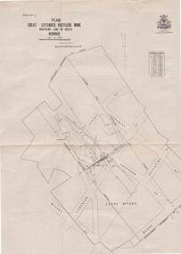
... Map, Hustler's Line of Reefs, Great Extended Hustler's Mine Plan, Plate No. X1 (11). Bulletin No 33 Signed H.A.Whitelaw Underground survey Office Bendigo September 1913....History House 11 Mackenzie Street Bendigo goldfields MAP Bendigo great extended hustler's mine Underground Survey Office, Bendigo. ...Map, Hustler's Line of Reefs, Great Extended Hustler's Mine Plan, Plate No. X1 (11). Bulletin No 33 Signed H.A.Whitelaw Underground survey Office Bendigo September 1913.Underground Survey Office, Bendigo.map, bendigo, great extended hustler's mine -
 Bendigo Historical Society Inc.
Map - STRUGNELL COLLECTION: HUSTLER'S LINE OF REEFS, BENDIGO, September 1913
... Map, Hustler's Line of Reefs, Great Extended Hustler's Mine Plan,Plate No X (10).Bulletin No 33 Signed H.A.Whitelaw Underground survey Office Bendigo September 1913 Drawing has a table showing depths of levels...History House 11 Mackenzie Street Bendigo goldfields MAP Bendigo great extended hustler's mine Underground Survey Office, Bendigo. ...Map, Hustler's Line of Reefs, Great Extended Hustler's Mine Plan,Plate No X (10).Bulletin No 33 Signed H.A.Whitelaw Underground survey Office Bendigo September 1913 Drawing has a table showing depths of levelsUnderground Survey Office, Bendigo.map, bendigo, great extended hustler's mine -
 Bendigo Historical Society Inc.
Map - STRUGNELL COLLECTION: HUSTLER'S LINE OF REEF, BENDIGO, September 1913
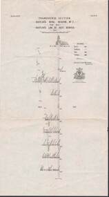
... Map, Hustler's Line of Reef, Hustler's Royal Reserve No. 2 Co, Bendigo,Transverse Section, Plate No.V11 (7). Bulletin No 33 Signed H.A.Whitelaw Underground survey Office Bendigo September 1913 Drawing shows mine shaft to over 1640 feet deep and appears to show samples of connecting horizontal shafts with their respective mineral contents...History House 11 Mackenzie Street Bendigo goldfields MAP Bendigo hustler's royal reserve no. 2 mine* Underground Survey Office, Bendigo. ...Map, Hustler's Line of Reef, Hustler's Royal Reserve No. 2 Co, Bendigo,Transverse Section, Plate No.V11 (7). Bulletin No 33 Signed H.A.Whitelaw Underground survey Office Bendigo September 1913 Drawing shows mine shaft to over 1640 feet deep and appears to show samples of connecting horizontal shafts with their respective mineral contentsUnderground Survey Office, Bendigo.map, bendigo, hustler's royal reserve no. 2 mine* -
 Bendigo Historical Society Inc.
Map - STRUGNELL COLLECTION: HUSTLER'S LINE OF REEFS, BENDIGO, September 1913
... Map, Hustler's Line of Reef, Hustler's Royal Reserve No. 2, Park Shaft, Bendigo, Plate No. 1X (9). Bulletin No 33 Signed H.A.Whitelaw Underground survey Office Bendigo September 1913 Drawing shows mine shaft to over 1099 feet deep and appears to show samples of connecting horizontal shafts with their respective mineral contents...History House 11 Mackenzie Street Bendigo goldfields MAP Bendigo hustler's royal reserve no. 2 mine* Underground Survey Office, Bendigo. ...Map, Hustler's Line of Reef, Hustler's Royal Reserve No. 2, Park Shaft, Bendigo, Plate No. 1X (9). Bulletin No 33 Signed H.A.Whitelaw Underground survey Office Bendigo September 1913 Drawing shows mine shaft to over 1099 feet deep and appears to show samples of connecting horizontal shafts with their respective mineral contentsUnderground Survey Office, Bendigo.map, bendigo, hustler's royal reserve no. 2 mine* -
 Bendigo Historical Society Inc.
Map - STRUGNELL COLLECTION: HUSTLER'S LINE OF REEFS, BENDIGO, September 1913
... Map, Hustler's Line of Reefs, Hustler's Royal Reserve No. 2 Mine, Bendigo.Plate No. V (5).. Great Extended Hustler's Lease, Imperial Hustler's, Hustler's Royal Reserve No. 2 Park & Main Shafts, Fortuna Hustler's Lease.Bulletin No 33 Signed H.A.Whitelaw Underground survey Office Bendigo September 1913...History House 11 Mackenzie Street Bendigo goldfields MAP Bendigo hustler's royal reserve no. 2 mine* Underground Survey Office, Bendigo. ...Map, Hustler's Line of Reefs, Hustler's Royal Reserve No. 2 Mine, Bendigo.Plate No. V (5).. Great Extended Hustler's Lease, Imperial Hustler's, Hustler's Royal Reserve No. 2 Park & Main Shafts, Fortuna Hustler's Lease.Bulletin No 33 Signed H.A.Whitelaw Underground survey Office Bendigo September 1913Underground Survey Office, Bendigo.map, bendigo, hustler's royal reserve no. 2 mine*