Showing 61 items matching "underground workings."
-
 Clunes Museum
Plan - PLANS, NEW NORTH CLUNES MINE - UNDERGROUND WORKINGS
... NEW NORTH CLUNES MINE - UNDERGROUND WORKINGS...UNDERGROUND WORKINGS....1 HEADER PAGE: "UNDERGROUND WORKINGS - NEW NORTH CLUNES MINE" .2 PLAN .3 PLAN TRANSVERSE SECTIONS .4 PLAN LONGITUDINALSECTIONS...Clunes Museum 36 Fraser Street enter building through Collins Place Clunes goldfields UNDERGROUND WORKINGS NEW NORTH CLUNES MINE .2 "656" PRINTED ON PLAN (FRONT)" .3 PRINTED ON PLAN R-272/.S/1B .4 R-272/S/1A .1 HEADER PAGE: "UNDERGROUND WORKINGS - NEW NORTH CLUNES MINE" .2 PLAN .3 PLAN TRANSVERSE SECTIONS .4 PLAN LONGITUDINALSECTIONS NEW NORTH CLUNES MINE - UNDERGROUND WORKINGS Plan PLANS ....1 HEADER PAGE: "UNDERGROUND WORKINGS - NEW NORTH CLUNES MINE" .2 PLAN .3 PLAN TRANSVERSE SECTIONS .4 PLAN LONGITUDINALSECTIONS.2 "656" PRINTED ON PLAN (FRONT)" .3 PRINTED ON PLAN R-272/.S/1B .4 R-272/S/1Aunderground workings, new north clunes mine -
Stawell Historical Society Inc
Map, Plan of the Principal Underground Workings at Stawell, 1894
... Plan of the Principal Underground Workings at Stawell...Plan of the Principal Underground Workings at Stawell...Stawell Historical Society Inc 46 Longfield St Stawell grampians stawell mining Plan of the Principal Underground Workings at Stawell Plan of the Principal Underground Workings at Stawell Map ...Plan of the Principal Underground Workings at Stawellstawell, mining -
 Bendigo Historical Society Inc.
Slide - ALBERT RICHARDSON COLLECTION: CENTRAL DEBORAH GOLD MINE, UNDERGROUND WORKINGS
... ALBERT RICHARDSON COLLECTION: CENTRAL DEBORAH GOLD MINE, UNDERGROUND WORKINGS......underground workings....History House 11 Mackenzie Street Bendigo goldfields MINE Gold underground workings. Bendigo Mines-Jack Hattam Collection. ...Slide. . Level at 1045 feet at New Moon Gold Mine, Eaglehawk. Crushing material 70 feet in width. Two men drilling while five look on. Image sourced from 'Healthy Golden Bendigo'No. 43 printed on bottom of slidemine, gold, underground workings., bendigo mines-jack hattam collection. -
 Bendigo Historical Society Inc.
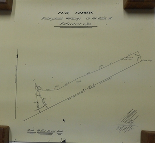
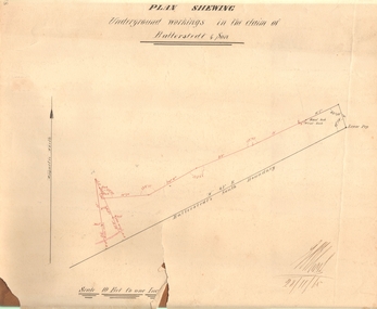
Document - MARKS COLLECTION: UNDERGROUND WORKINGS BALLERSTED & SON
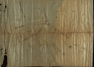
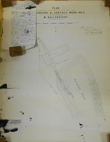
... MARKS COLLECTION: UNDERGROUND WORKINGS BALLERSTED & SON...Plan on white paper (copy) of underground workings. On top of plan 'Plan Showing Underground Workings in the claim of Ballerstedt & Son' On bottom date written 29/11/65. ...Document MARKS COLLECTION: UNDERGROUND WORKINGS BALLERSTED & SON ...Plan on white paper (copy) of underground workings. On top of plan 'Plan Showing Underground Workings in the claim of Ballerstedt & Son' On bottom date written 29/11/65. Plan shows lease peg, southern boundary of claim.bendigo, mining, ballerstedt & co -
 Federation University Historical Collection
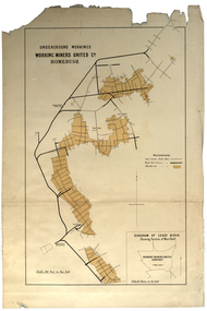
Plan, Underground Workings, Working Miners United Co. Homebush
... Underground Workings, Working Miners United Co. Homebush...underground workings...underground workings plan working miners united co homebush various measurements and locations Printed map on paper Underground Workings, Working Miners United Co. ...Printed map on paper various measurements and locationsunderground workings, plan, working miners united co, homebush -
 Bendigo Historical Society Inc.
Plan - MARKS COLLECTION: PLAN OF UNDERGROUND WORKINGS CINDERELLA COMPANY, JOHNSON'S REEF
... MARKS COLLECTION: PLAN OF UNDERGROUND WORKINGS CINDERELLA COMPANY, JOHNSON'S REEF...Plan on heavy parchment paper: on top of plan 'Plan of the underground workings Cinderella Company, Johnson's Reef' Lh side of plan 'Kent Company's Ground' on bottom: Tipper and Company. ...Plan MARKS COLLECTION: PLAN OF UNDERGROUND WORKINGS CINDERELLA COMPANY, JOHNSON'S REEF ...Plan on heavy parchment paper: on top of plan 'Plan of the underground workings Cinderella Company, Johnson's Reef' Lh side of plan 'Kent Company's Ground' on bottom: Tipper and Company. Written on bottom surveyed 13/7/64.bendigo, mining, cinderella company -
 Coal Creek Community Park & Museum
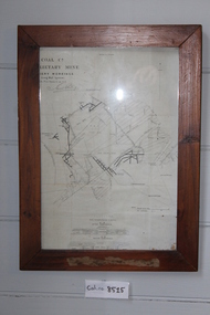
Farmed Mine Map, Map Of Underground Workings of Coal Creek Mine, 1896
... Map Of Underground Workings of Coal Creek Mine...Frame has a paper label rotted and faded almost beyond legibility. Map Of Underground Workings of Coal Creek Mine Farmed Mine Map ...8515.1 - Map of underground tunnels at a coal creek mine. Frame has a paper label rotted and faded almost beyond legibility. -
Stawell Historical Society Inc
Map, Gold Mines of Australia, Gold Mines of Australia underground workings. Newington Rd Darlington Rd Area 1950, 1950
... Gold Mines of Australia underground workings. Newington Rd Darlington Rd Area 1950...Stawell Historical Society Inc 46 Longfield St Stawell grampians mining gold map Gold Mines of Australia Stawell Investment 2003 Plans Showing Surveys & Drilling Stawell Investment Gold Mines of Australia underground workings. Newington Rd Darlington Rd Area 1950 Map Gold Mines of Australia ...Plans Showing Surveys & Drilling Stawell InvestmentGold Mines of Australia Stawell Investment 2003 mining, gold, map -
Stawell Historical Society Inc
Map, Crocodile Gold Corp, Photographic Aerial View of Big Hill showing underground workings and surface workings and proposed Big Hill Open Pit proposal, December 2014
... Photographic Aerial View of Big Hill showing underground workings and surface workings and proposed Big Hill Open Pit proposal....Photographic Aerial View of Big Hill showing underground workings and surface workings and proposed Big Hill Open Pit proposal. ...Crocodile Gold Corp SGM photo Map showing Magdala Decline& Wonga Decline December 2014 Produced for Public Consultation over Big Hill Open Pit Proposal. Aerial Views Stawellmining, gold, map -
Stawell Historical Society Inc
Map, H C Bates Surveyor, Plan of Underground Workings. 1888, 25/8/1888
... Plan of Underground Workings. 1888...Stawell Historical Society Inc 46 Longfield St Stawell grampians gold mining Scale 80ft to an inch H C Bates Mining Surveyor 25/8/88 Magdala Co Now Moonlight Co Stawell Plan of Underground Workings. 1888 Map H C Bates Surveyor ...goldMagdala Co Now Moonlight Co StawellScale 80ft to an inch H C Bates Mining Surveyor 25/8/88mining -
Stawell Historical Society Inc
Archive - CD/DVD, Gold Mining Relics of the Past - Surface and underground. Plan view of underground mine. Photographs of various mine sites. Underground workings of various mines, 2003
... Photographs of various mine sites. Underground workings of various mines....Photographs of various mine sites. Underground workings of various mines. Archive CD/DVD ...stawell, mines, relics, stokes, timbers -
 Federation University Historical Collection
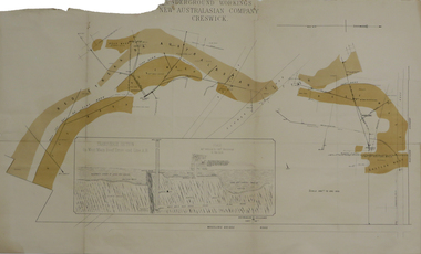
Plan, Underground Workings New Australasian Company Creswick, not dated
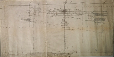
... Underground Workings New Australasian Company Creswick...It als shows the locations of the Red streak or Australasian Gutter, Reef wash, Eastern Wash, Australasian and Eaglehawk Shaft and prospecting drives. Underground Workings New Australasian Company Creswick Plan Plan ...A plan of the underground working of the New Australasian Mine at Creswick, showing Wheeler's Bridge Road, a transverse section on the West Main Reef Drive and Line AB. It als shows the locations of the Red streak or Australasian Gutter, Reef wash, Eastern Wash, Australasian and Eaglehawk Shaft and prospecting drives.mining, plans, cgt, creswick, new australasian company, wheeler's bridge, red streak gutter, australasian gutter, reef wash, eastern wash, australiasian shaft, eaglehawk shaft -
 Federation University Historical Collection
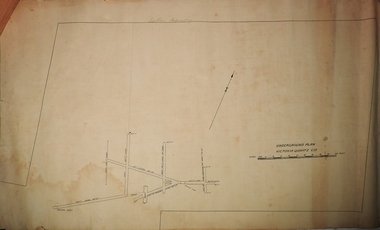
Plan, Unidentified mine - underground workings
... Unidentified mine - underground workings ...Unidentified mine - underground workings Plan Plan ...Plan showing underground drives. Ink on linen with green and brown shading. Red line.cgt, mining, plan, prospecting -
 Bendigo Historical Society Inc.
Document - MARKS COLLECTION: PLAN RELATING TO UNDERGROUND AND SURFACE WORKINGS VICTORIA HILL
... MARKS COLLECTION: PLAN RELATING TO UNDERGROUND AND SURFACE WORKINGS VICTORIA HILL...Plan on paper: on top of plan 'plan showing the position of the underground & surface workings in the claim of Mr. Ballerstedt Victoria Hill' Signed by Thomas Forbes, Mining Surveyor, 22nd. ...I may state that I have inspected the underground workings generally in the mine, and the timbering is of the most substantial character Document MARKS COLLECTION: PLAN RELATING TO UNDERGROUND AND SURFACE WORKINGS VICTORIA HILL ...Plan on paper: on top of plan 'plan showing the position of the underground & surface workings in the claim of Mr. Ballerstedt Victoria Hill' Signed by Thomas Forbes, Mining Surveyor, 22nd. April 1868' Attached to plan is a letter report accompanying plans on the underground workings in (illegible) Ballerstedt & Sons, Victoria Hill (ink blot covering writing RH side) Text of letter begins : the underground level southwards from the shaft is 4ft 6' x 6 ft wide as shown on the plan; and is at a depth of (illegible) from the surface; along the (illegible) of which the timbering both upright and cap-pieces; are now in as good condition as when the work was being proceed with; with the exception of the uprights and one cap-piece which are slightly crushed from the general settlement of the mullock. The timbering of the drives is still standing in the same position though upwards of 12 months has elapsed after the slip in the open cutting had taken place, showing very clearly in my mind that the slip could not be attributable to the insufficient timbering of the underground workings; but rather to the action of the weather in this particular part of the cutting. The probably quantity of mullock that was detached or slipped from the west side of the cutting; would be (from careful enquiry and observation ) about 1500 loads at least; enough to crush the whole of the timber in the levels, if it had not been of the most substantial character and I think yours to prove that the fall was not caused by any defective timbering but from the cause already stated. I may state that I have inspected the underground workings generally in the mine, and the timbering is of the most substantial characterbendigo, mining, victoria hill -
 Stawell Historical Society Inc
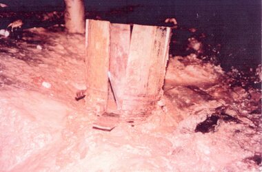
Photograph, Blasting Powder Keg found underground when mine workings re-opened 1982-1983
... Blasting Powder Keg found underground when mine workings re-opened 1982-1983...Blasting Powder Keg found underground when mine workings re-opened 1982-1983...Blasting Powder Keg found underground when mine workings re-opened 1982-1983 Photograph ...Blasting Powder Keg found underground when mine workings re-opened 1982-1983Coloured photo of timber pieces upright in a cleared area.stawell -
Stawell Historical Society Inc
Map, Underground Mine Workings Stawell, 1894
... Underground Mine Workings Stawell...Stawell Historical Society Inc 46 Longfield St Stawell grampians Stawell Mining Plans Plan and Elevations of mine workings 12 September 1894. J H Bate Mining Surveyor. Framed under Glass Underground Mine Workings Stawell Map ...Plan and Elevations of mine workings 12 September 1894. J H Bate Mining Surveyor. Framed under Glassstawell, mining, plans -
Stawell Historical Society Inc
Map, Sloanes & Scotchmans Company showing underground drives, c1900
... Underground Workings Mapc1900...Stawell Historical Society Inc 46 Longfield St Stawell grampians mining gold map Sloanes & Scotchmans Coy Underground Workings Mapc1900 Sloanes & Scotchmans Company showing underground drives Map ...Underground Workings Mapc1900Sloanes & Scotchmans Coy mining, gold, map -
Stawell Historical Society Inc
Map, Stawell Gold Mines Pty Ltd, Plan of Magdala Mine. May 1994, May 1994
... AO Printed Map In Colour. Showing Underground Workings and Portal...Scale 1 : 2500 AO Printed Map In Colour. Showing Underground Workings and Portal Plan of Magdala Mine. ...Moonlight Junction, Big Newington Co. Pleasants Creek and Newington, Prince Patrick, North Cross Extended, Prince Alfred, Robson and Party, North Magdala, Galatea and Pioneer Co., Duke Magdal, Moonlight, Moonlight Extended, Sliding Shaft, Extended Cross, Crown Cross United, Great Northern, Sloanes and Scotchmans, Marinees, North Waterloo, Scothmans United, Waterloo, Scotchmans Iron Duke and Bulcher, Perthen Shire, Prince of Wales, Roberts, Shafts of Rose of Denmark, Emerald Isle Shafts, O'Donnels, Darlington,, Albion, Federal, Ulster, Goldenpoint and Wexford.AO Printed Map In Colour. Showing Underground Workings and PortalScale 1 : 2500 -
 Bendigo Historical Society Inc.
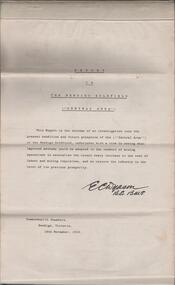
Document - REPORT ON THE BENDIGO GOLDFIELD, EDWARD DYASON
... ... underground workings...History House 11 Mackenzie Street Bendigo goldfields BENDIGO Gold mining report on goldfield Bendigo goldfield goldmining mining companies reef lines underground workings E.C. Dyason Grey cover document, 21 typed pages with map of goldfield appended. ...Grey cover document, 21 typed pages with map of goldfield appended. On front page 'Report on the Bendigo Goldfield Central Area. This report is the outcome of an investigation into the present condition and future prospects of the Central Area of the Bendigo goldfield, undertaken with a view to seeing what improved methods could be adopted in the conduct of mining operations to neutralise the recent heavy increase in the cost of labour and mining requisites, and so restore the industry to the level of its previous prosperity' Signed by E.C. Dyason, B.Sc. B.M.E., Commonwealth Chambers, Bendigo, Victoria, 15th November, 1918.bendigo, gold mining, report on goldfield, bendigo goldfield, goldmining, mining companies, reef lines, underground workings, e.c. dyason -
Clunes Museum
Map - MAPS/DOCUMENTS
... DOCUMENTATION AND MAPS DESCRIBING THE WORKINGS OF THE PORT PHILLIP MINE, SHOWING 54 FEET DEEP OF THE UNDERGROUND WORKINGS....Clunes Museum 36 Fraser Street enter building through Collins Place Clunes goldfields INFORMATION local history mining PORT PHILLIP MINE DOCUMENTATION AND MAPS DESCRIBING THE WORKINGS OF THE PORT PHILLIP MINE, SHOWING 54 FEET DEEP OF THE UNDERGROUND WORKINGS. Map MAPS/DOCUMENTS ...INFORMATIONDOCUMENTATION AND MAPS DESCRIBING THE WORKINGS OF THE PORT PHILLIP MINE, SHOWING 54 FEET DEEP OF THE UNDERGROUND WORKINGS.local history, mining, port phillip mine -
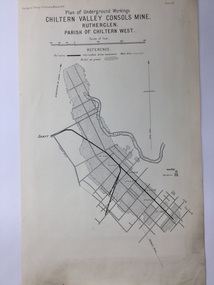 Rutherglen Historical Society
Map, 1908
... Plate XX Plan of Underground Workings CHILTERN VALLEY CONSOLS MINE, RUTHERGLEN, PARISH OF CHILTERN WEST...Plate XX Plan of Underground Workings CHILTERN VALLEY CONSOLS MINE, RUTHERGLEN, PARISH OF CHILTERN WEST Cream paper, black printing, rectangle with a drawing Map ...This is a map produced as part of a book entitled.. It is also stamped on the back in blue ink with an oval ring and the words North of England Institute. Newcastle. Mining & Meterolgical Faculty. Purchased on 23rd July 2017 by the Society after research by member Simon Killeen. Mining map of one of the first mines in Rutherglen area ( Chiltern West)Cream paper, black printing, rectangle with a drawingGeographical Survey of Victoria, Memoir, No6. Plate XX Plan of Underground Workings CHILTERN VALLEY CONSOLS MINE, RUTHERGLEN, PARISH OF CHILTERN WESTgold, rutherglen, mining, chiltern, underground mine map, geological survey, reef drives -
 Bendigo Historical Society Inc.
Plan - Mine Map
... Transverse section of un-named mine showing underground workings and geological features. Forms part of the Margaret Roberts Collection of mining records....History House 11 Mackenzie Street Bendigo goldfields Bendigo Margaret Roberts gold Map Mine Margaret Roberts Collection Transverse section of un-named mine showing underground workings and geological features. Forms part of the Margaret Roberts Collection of mining records. ...Transverse section of un-named mine showing underground workings and geological features. Forms part of the Margaret Roberts Collection of mining records.bendigo, margaret roberts, gold, map, mine, margaret roberts collection -
Bendigo Historical Society Inc.
Map - RAYWOOD GOLD FIELD MAP, 1902
... It shows underground workings from The Perseverance Party and moreshed and Party and underground workings on the Old Pioneer Reef. ...It shows underground workings from The Perseverance Party and moreshed and Party and underground workings on the Old Pioneer Reef. ...Map. Raywood Gold Field Map. Linen backed map of Raywood and Neilborough Township and surrounds showing the location of varying underground workings. Surveyed by H S Whitelaw 1/6/02. It shows underground workings from The Perseverance Party and moreshed and Party and underground workings on the Old Pioneer Reef. Mentions the Parish of Yallook, Parish of Neilborough, Yarraberb, Mushroom Flat, Murray Valley Plain, Eaglehawk and Kerang Railway, Green Hill, Doughboy, Redmond's Gully, Pickpocket Lead, Raywood Lead, Inglewood Lead, Shaw's Road, Nuggety Shaft, Barkly Shaft, Maori Bendmap, gold field map, raywood gold field map, neilborough, h s whitelaw, geological survey of victoria bulletin no 12 plate 11 -
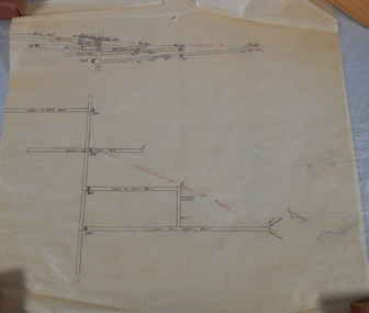
 Bendigo Historical Society Inc.
Document - MARKS COLLECTION: PLAN OF UNDERGROUND WORKING IN BALLERSTEDT & SON MINE, 28th November, 1965
... Plan shows underground workings in red, with distances and angles. ...Plan shows underground workings in red, with distances and angles. ...Buff coloured document, heavy parchment, printed in black. On top of plan 'plan showing underground workings in the claim of Ballerstedt & Son.' Plan shows underground workings in red, with distances and angles. On bottom of drawing 'Ballerstedt's South Boundary'. Signed on bottom in black ink (indecipherable signature) and dated 28.11.65. Document attached is related to the donor Phillipa Marks' family and contains the recollections of her great grandfather in regard to Bendigo's Jewish community and synagogues.bendigo, mining, ballerstedt & son mine -
 Bendigo Historical Society Inc.
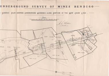
Map - STRUGNELL COLLECTION: NEW CHUM LINE, 25/5/01
... Map, Surface Plan Showing underground workings along portion of the New Chum Line.South Belle Vue United, Eureka Extended, New Chum Railway, Shenandoah Co. ...History House 11 Mackenzie Street Bendigo goldfields MAP Bendigo new chum line A.S.Whitelaw Map, Surface Plan Showing underground workings along portion of the New Chum Line.South Belle Vue United, Eureka Extended, New Chum Railway, Shenandoah Co. ...Map, Surface Plan Showing underground workings along portion of the New Chum Line.South Belle Vue United, Eureka Extended, New Chum Railway, Shenandoah Co. Shamrock Co..A.S.Whitelawmap, bendigo, new chum line -
 Bendigo Historical Society Inc.
Plan - North Argus Mine
... Plan of North Argus Mine underground workings, drawn on light waxed paper. 'W.H. ...Bendigo Margaret Roberts gold North Argus Mine Eaglehawk Plan of North Argus Mine underground workings, drawn on light waxed paper. 'W.H. ...The North Argus Gold Mine was located near the intersection of Cook Street and Moon Street, Eaglehawk. Plan of North Argus Mine underground workings, drawn on light waxed paper. 'W.H. Cundy, Mining Surveyor, December 23rd, 1901', hand written on plan. Forms part of the Margaret Roberts Collection bendigo, margaret roberts, gold, north argus mine, eaglehawk -
 Bendigo Historical Society Inc.
Plan - Central Blue Gold Mine, Unknown
... Longitudinal plan of Central Blue and Little 180 gold mines underground workings. Hand drawn in pencil, with shadings. ...Korong Road. gold mining gold Bendigo central blue Longitudinal plan of Central Blue and Little 180 gold mines underground workings. Hand drawn in pencil, with shadings. ...Lansell's Little 180 gold mine was located on the corner of Alley Street and Mt. Korong Road. Longitudinal plan of Central Blue and Little 180 gold mines underground workings. Hand drawn in pencil, with shadings. Shafts marked: Central Blue and Sheepshead shaft. Plan forms part of the Margaret Roberts Collection.gold mining, gold, bendigo, central blue -
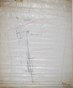
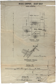 Federation University Historical Collection
Plan, Midas Company, Sulky Gully near Creswick
... Locality and Underground Workings plan for the Midas Company, Sulky Gully near Creswick. ...dowling forest no 1. midas consols madam midas midas company king midas sulky gully creswick midas extended cgt Locality and Underground Workings plan for the Midas Company, Sulky Gully near Creswick. ...Locality and Underground Workings plan for the Midas Company, Sulky Gully near Creswick. Companies shown on the Locality Plan include Dowling Forest No 1., Midas Consols, Madam Midas, Midas Company, King Midas and Midas Extended.dowling forest no 1., midas consols, madam midas, midas company, king midas, sulky gully, creswick, midas extended, cgt -
 Bendigo Historical Society Inc.
Plan - Victoria Quartz Gold Mine, Unknown
... Printed in black text on light tan paper: 'Underground workings, Victoria Quartz Co''. Written on accompanying label: "Victoria Reef, underground plan'. ...The mine closed in 1913, having produced over 48,000 ounces of gold and paid dividends of £99,600. gold mining gold Bendigo Victoria Quartz Gold Mine Victoria Reef Printed in black text on light tan paper: 'Underground workings, Victoria Quartz Co''. Written on accompanying label: "Victoria Reef, underground plan'. ...Victoria Quartz Gold Mine was situated on Victoria Hill, Bendigo. Victoria Hill is situated on the Marong Road, opposite the Gold Mines Hotel. Victoria Hill was one of the richest areas on the Bendigo Goldfield. It had many successful mines, including Lansell's '180' and the Victoria Quartz, once the deepest gold mine in the world. At the turn of the century, this was the site of one of the premier mines on the Bendigo goldfield. In 1908, it boasted the world's deepest shaft - 4,478 feet (1,365 metres). The shaft reached a depth of 4,613 feet (1,406 metres) in 1910. In 1857 eight small claims in this area had been merged to form the Victoria Reef Quartz Mining Co. Another merger in 1877 led to the formation of the Victoria Quartz Co. For the next three decades, the mine produced consistent profits. In 1910, water burst into the claim, flooding the shaft and halting operations. The company baled water for six months then handed the mine over to the tributers who worked the upper levels for the share of the profits. The mine closed in 1913, having produced over 48,000 ounces of gold and paid dividends of £99,600.Printed in black text on light tan paper: 'Underground workings, Victoria Quartz Co''. Written on accompanying label: "Victoria Reef, underground plan'. Plan shows shaft, drives and geological features. Plan forms part of the Margaret Roberts Collection.gold mining, gold, bendigo, victoria quartz gold mine, victoria reef -
 Bendigo Historical Society Inc.
Plan - Victory and Mt. Gahn Co
... Plan shows longitudinal section and, secondly, plan of underground workings on the horizontal plane. Written on top of plan: 'Victory and Mt. ...Plan shows longitudinal section and, secondly, plan of underground workings on the horizontal plane. Written on top of plan: 'Victory and Mt. ...Victory and Mt. Gahn Co. was located near Pambula, New South Wales. Victory and Mt. Gahn Co. mine workings. Plan shows longitudinal section and, secondly, plan of underground workings on the horizontal plane. Written on top of plan: 'Victory and Mt. Gahn Co. 40 ft to and inch' Plan forms part of the Margaret Roberts Collection of mining records. margaret roberts, gold, gold mine, victory and mt.gahn