Showing 24 items matching "village pond"
-
 Eltham District Historical Society Inc
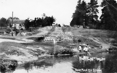
Negative - Photograph, Village Pond, near Main Road, Eltham, c.1908
... Village Pond, near Main Road, Eltham......Village Pond...Village Pond, near Main Road, Eltham, c.1908 Reproduced on p57 of 'Pioneers & Painters'. ...Eltham District Historical Society Inc 728 Main Rd Eltham melbourne Village Pond, near Main Road, Eltham, c.1908 Reproduced on p57 of 'Pioneers & Painters'. ...Village Pond, near Main Road, Eltham, c.1908 Reproduced on p57 of 'Pioneers & Painters'. Looking up Dalton Street from across Maria Street (Main Road), near Whitecloud (Jarrold’s cottage) and the Bootmaker’s cottage, to the left (out of view) of the photographer. The residence of the Head Teacher, Eltham State School No. 209, can be seen on the right, the Grant house on the left (site of present day Eltham Clinic). The willow trees south of Jarrold’s Cottage today mark the site of the old pond, which the Eltham Shire Council evidently filled in to stop mosquitos breeding. The pond and its locality was described in an article about Eltham published in The Australasian, May 2, 1903 - “There is the village pond (so essentially English), reflecting in its clear water a quaint cottage, dwarfed by a huge gum tree, an old smithy, and a hostelry, built quite fifty years ago, the flooring-boards of which the landlord informed me with pride were of Singapore cedar, and quite fit for another fifty years' wear. Then there are the village school, the shoemaker's, the drapery store, and the butcher's shop, all seemingly as they were when first they were erected many years ago.”This photo forms part of a collection of photographs gathered by the Shire of Eltham for their centenary project book,"Pioneers and Painters: 100 years of the Shire of Eltham" by Alan Marshall (1971). The collection of over 500 images is held in partnership between Eltham District Historical Society and Yarra Plenty Regional Library (Eltham Library) and is now formally known as the 'The Shire of Eltham Pioneers Photograph Collection.' It is significant in being the first community sourced collection representing the places and people of the Shire's first one hundred years.Digital image 4 x 5 inch B&W Neg Print 16.5 x 25 cm (2) and 9 x 12.5 cm Postcard 9 x 14 cmOn one print "57 and 11 3/8' x 10' deep"shire of eltham pioneers photograph collection, dalton street, duck pond, eltham, grant house, main road, maria street, village pond -
 Eltham District Historical Society Inc
Photograph, Peter Pidgeon, Site of the former Village Pond, Main Road, Eltham, 2 Aug. 2022
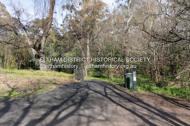
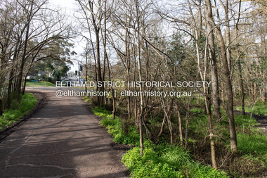
... Site of the former Village Pond, Main Road, Eltham......Village Pond...Comparative photo taken 2022 with one taken from same location over 100 tears earlier by noted local photographer John Henry Clark Eltham Dalton Street Main Road diamond creek trail Village Pond Wingrove Park Trail Born Digital Site of the former Village Pond, Main Road, Eltham Photograph Photograph Peter Pidgeon ...View looking looking southwest from the Diamd Creek Trail opposite Dalton Street on Main Road where the former pond was situated. The pond was drained by Council in 1932 due to concerns of mosquitoes, etc against the wishes of long standing residents such as Thekla Jarrold (39 years) and John Clark (22 years).Comparative photo taken 2022 with one taken from same location over 100 tears earlier by noted local photographer John Henry ClarkBorn Digitaleltham, dalton street, main road, diamond creek trail, village pond, wingrove park trail -
 Eltham District Historical Society Inc
Photograph, Peter Pidgeon, Site of the former Village Pond, Main Road, Eltham, 2 Aug. 2022
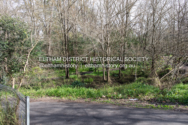
... Site of the former Village Pond, Main Road, Eltham......Village Pond...Eltham Dalton Street Main Road diamond creek trail Village Pond Wingrove Park Trail Born Digital Site of the former Village Pond, Main Road, Eltham Photograph Photograph Peter Pidgeon ...View looking looking southwest from the Diamd Creek Trail opposite Dalton Street on Main Road where the former pond was situated. The pond was drained by Council in 1932 due to concerns of mosquitoes, etc against the wishes of long standing residents such as Thekla Jarrold (39 years) and John Clark (22 years).Born Digitaleltham, dalton street, main road, diamond creek trail, village pond, wingrove park trail -
 Eltham District Historical Society Inc
Photograph, Peter Pidgeon, Site of the former Village Pond, Main Road, Eltham, 2 Aug. 2022
... Site of the former Village Pond, Main Road, Eltham......Village Pond...Eltham Dalton Street Main Road diamond creek trail Village Pond Wingrove Park Trail Born Digital Site of the former Village Pond, Main Road, Eltham Photograph Photograph Peter Pidgeon ...View looking looking southwest from the Diamond Creek Trail opposite Dalton Street on Main Road where the former pond was situated. The pond was drained by Council in 1932 due to concerns of mosquitoes, etc against the wishes of long standing residents such as Thekla Jarrold (39 years) and John Clark (22 years).Born Digitaleltham, dalton street, main road, diamond creek trail, village pond, wingrove park trail -
 Eltham District Historical Society Inc
Photograph, Peter Pidgeon, Site of the former Village Pond, Main Road, Eltham, 2 Aug. 2022
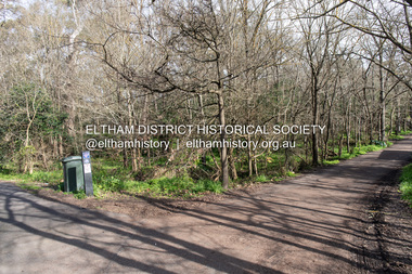
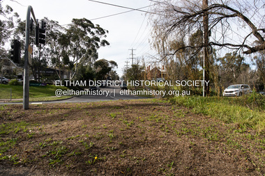
... Site of the former Village Pond, Main Road, Eltham......Village Pond...Eltham Dalton Street Main Road diamond creek trail Village Pond Wingrove Park Trail Born Digital Site of the former Village Pond, Main Road, Eltham Photograph Photograph Peter Pidgeon ...View looking looking east along the Wingrove Park Trail opposite Dalton Street on Main Road where the former pond was situated. The pond was drained by Council in 1932 due to concerns of mosquitoes, etc against the wishes of long standing residents such as Thekla Jarrold (39 years) and John Clark (22 years).Born Digitaleltham, dalton street, main road, diamond creek trail, village pond, wingrove park trail -
 Eltham District Historical Society Inc
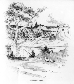
Photograph, The Australasian, Village Pond, Eltham, 2 May 1903
... Village Pond, Eltham......Village Pond...It is significant in being the first community sourced collection representing the places and people of the Shire's first one hundred years. sepp shire of eltham pioneers photograph collection eltham Dalton Street Jarrold Cottage Main Road Maria Street Village Pond White Cloud Cottage Digital image Print Slide 35mm Village Pond, Eltham Photograph Photograph The Australasian ...This photo forms part of a collection of photographs gathered by the Shire of Eltham for their centenary project book,"Pioneers and Painters: 100 years of the Shire of Eltham" by Alan Marshall (1971). The collection of over 500 images is held in partnership between Eltham District Historical Society and Yarra Plenty Regional Library (Eltham Library) and is now formally known as the 'The Shire of Eltham Pioneers Photograph Collection.' It is significant in being the first community sourced collection representing the places and people of the Shire's first one hundred years.Digital image Print Slide 35mmsepp, shire of eltham pioneers photograph collection, eltham, dalton street, jarrold cottage, main road, maria street, village pond, white cloud cottage -
 Eltham District Historical Society Inc
Photograph, Peter Pidgeon, Site of the former Village Pond, Main Road, Eltham, 2 Aug. 2022
... Site of the former Village Pond, Main Road, Eltham...Eltham Dalton Street Main Road Eltham Clinic Eltham Primary School Headmaster's Residence State School No. 209 Born Digital Site of the former Village Pond, Main Road, Eltham Photograph Photograph Peter Pidgeon ...View looking up Dalton Street from near Main Road where the former pond was situated. The pond was drained by Council in 1932 due to concerns of mosquitoes, etc against the wishes of long standing residents such as Thekla Jarrold (39 years) and John Clark (22 years). On the right is the Eltham Primary Schoool No. 209 with the former Headmaster's residence and to the left is Eltham Clinic once the site of the Grant home.Born Digitaleltham, dalton street, main road, eltham clinic, eltham primary school, headmaster's residence, state school no. 209 -
 Eltham District Historical Society Inc
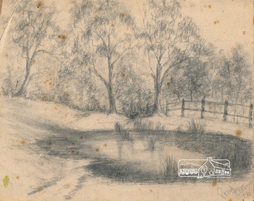
Greeting Card, Pond, Eltham; sketch by E.G
... ...village pond...The sketch is of the village pond at the bottom the hill on Maria Street (Main Road) oppiste Dalton Street. ...Eltham District Historical Society Inc 728 Main Rd Eltham melbourne The sketch is of the village pond at the bottom the hill on Maria Street (Main Road) oppiste Dalton Street. ...The sketch is of the village pond at the bottom the hill on Maria Street (Main Road) oppiste Dalton Street. The artist's initials are E.G. It is possible that these are for Edward Gadd, the village blacksmith whose blacksmith shop was next to the Courthouse just up the hill from the pond. Pages from a scrapbook belonging to Heather Jenkins (nee Cone) who lived as a child in the Police Residence at 728 Main Road, Eltham in the 1920s.Heather Jenkins was the daughter of Constable John Thomas Cone, Badge #3935 served at Eltham Police Station 1 May 1911 to 9 July 1922.Glued on a brown paper scrapbook page (torn from scrapbook) with 8 black and white/sepia photos of varying sizes, 1 newspaper clipping and one greeting card with printed sketch and handwritten captions in ink. On back of page is 1 black and white photo and a large newspaper clipping.eltham, village pond, edward gadd, artwork, heather jenkins (nee cone), sketches -
 Eltham District Historical Society Inc
Photograph, The Australasian, Eltham - A series of four scenes of the local district, 2 May 1903
... ...village pond...Sketches illustrating the article: VILLAGE POND. DRAPERY STORE, ELTHAM. ON DIAMOND CREEK. ...Sketches illustrating the article: VILLAGE POND. DRAPERY STORE, ELTHAM. ON DIAMOND CREEK. ...Australasian (Melbourne, Vic. : 1864 - 1946), Saturday 2 May 1903, page 25 ________________________________________ ELTHAM A POPULAR HOLIDAY SPOT. By L.J.J. The village of Eltham, with its 377 in habitants, is prettily situated on Diamond Creek, a tributary of the Yarra, 16 miles from Melbourne. Yet, in spite of it being so easily accessible from town, few people are aware of the beauties of this early settlement. Prior to June last year one had to journey by coach from Heidelberg to Eltham, but now the railway conveys passengers through from Melbourne to Eltham, first-class return, for 1/9. The opening of this extension to Eltham was the last ceremony performed by Lord Hopetoun, on June 5, 1902, prior to his departure from Australia. Sauntering through the township one autumn morning recently I was constantly reminded of scenes characteristic of Surrey or Sussex villages. There is the village pond (so essentially English), reflecting in its clear water a quaint cottage, dwarfed by a huge gum tree, an old smithy, and a hostelry, built quite fifty years ago, the flooring-boards of which the landlord informed me with pride were of Singapore cedar, and quite fit for another fifty years' wear. Then there are the village school, the shoemaker's, the drapery store, and the butcher's shop, all seemingly as they were when first they were erected many years ago. Poplars grow to a great height at Eltham, and just now they are to be seen in rich autumnal tints. The already leafless fruit trees on the slopes of the creek denote the near approach of winter. Orchardists were taking advantage of the recent rains, and were busy ploughing and harrowing between the trees, while the magpies and other birds were picking up worms and grubs on the newly-turned soil. The busy time for Eltham is the holiday season, and then the inhabitants are put to their wits' ends to provide for the rush of picnic parties, cyclists, and other excursionists. Outside almost every cottage is a notice stating that "summer drinks and hot water" are obtainable. Sketches illustrating the article: VILLAGE POND. DRAPERY STORE, ELTHAM. ON DIAMOND CREEK. HOSTELRY, ELTHAM. AN ORCHADIST'S HOMESTEAD. ON THE HEIDELBERG-ROAD IN AND AROUND ELTHAM.This photo forms part of a collection of photographs gathered by the Shire of Eltham for their centenary project book,"Pioneers and Painters: 100 years of the Shire of Eltham" by Alan Marshall (1971). The collection of over 500 images is held in partnership between Eltham District Historical Society and Yarra Plenty Regional Library (Eltham Library) and is now formally known as the 'The Shire of Eltham Pioneers Photograph Collection.' It is significant in being the first community sourced collection representing the places and people of the Shire's first one hundred years.Digital image Print B&W 20 x 25 cmsepp, shire of eltham pioneers photograph collection, drapery store, hostelery, orchardist's homestead, village pond, eltham, dalton street, evelyn hotel, hostelry, jarrold cottage, john street, main road, maria street, white cloud cottage -
 Eltham District Historical Society Inc
Book, Diamond Creek Basin Study. Part 1, A Compendium of Factors Relevant to Stormwater Flows, 1980
... ...village pond...Eltham District Historical Society Inc 728 Main Rd Eltham melbourne Basin Studies are studies to evaluate water supply and demand and help ensure reliable water supplies by identifying strategies to address imbalances in water supply and demand. aerial photographs allendale road arthurs creek mine arthurs creek road bridge arthurs creek bald spur look-out bank protection bolton steet bridge street bridge bridge street bridges challenger street chute street construction coolaroo drive culvert deep creek diamond creek basin diamond creek region diamond creek diamond street bridge drainage works eltham lower park eltham town park eltham trestle bridge eltham west drains eltham erosion flood management floods footbridge glen katherine estate gold mining gum glade hurstbridge kangaroo ground kinglake escarpment kinglake national park latiners hat factory main road bridge main road masons falls melbourne metropolitan board of works, monash bridge mount sugarloaf nillumbik park orchards railway culvert railway line ramptons road real estate advertisement research creek st helena east drain st helena road st helena storm sewers stormwater sugarloaf-preston transfer main crossing susan street union mine village pond water flow watkins street wattletree road weidlich road wingrove park yarra river zig zag road water supply basin study Spiral Bound. 157 leaves in various foliations (some folded) : illustrated. ...Basin Studies are studies to evaluate water supply and demand and help ensure reliable water supplies by identifying strategies to address imbalances in water supply and demand.Spiral Bound. 157 leaves in various foliations (some folded) : illustrated. (some colour.), maps (some colour.)aerial photographs, allendale road, arthurs creek mine, arthurs creek road bridge, arthurs creek, bald spur look-out, bank protection, bolton steet, bridge street bridge, bridge street, bridges, challenger street, chute street, construction, coolaroo drive, culvert, deep creek, diamond creek basin, diamond creek region, diamond creek, diamond street bridge, drainage works, eltham lower park, eltham town park, eltham trestle bridge, eltham west drains, eltham, erosion, flood management, floods, footbridge, glen katherine estate, gold mining, gum glade, hurstbridge, kangaroo ground, kinglake escarpment, kinglake national park, latiners hat factory, main road bridge, main road, masons falls, melbourne metropolitan board of works, monash bridge, mount sugarloaf, nillumbik park, orchards, railway culvert, railway line, ramptons road, real estate advertisement, research creek, st helena east drain, st helena road, st helena, storm sewers, stormwater, sugarloaf-preston transfer main crossing, susan street, union mine, village pond, water flow, watkins street, wattletree road, weidlich road, wingrove park, yarra river, zig zag road, water supply, basin study -
 Bendigo Military Museum
Postcard - POSTCARD, ASH, U.K, F. Frith and Co, c. WW1
... Bob.' 6. Ash Village and Pond: Handwritten in faded black ink on back: 'Letter to Elsie from R.H. ...Bob.' 6. Ash Village and Pond: Handwritten in faded black ink on back: 'Letter to Elsie from R.H. ...Cards collected by R.H. Baron when visiting his Uncle who lived near the village of ASH, UK. c.Nov 1918. Part of the "Robert H. Baron", No. 3596 and Cooper Collections. See Catalogue No. 1981P for details of Baron's service.1. Coloured photograph of a street featuring building including a Post Office. 2. Coloured photograph of a house fronting a gravel road. 3. Sepia toned photograph of a gravel road, vegetation and trees. 4. Sepia toned photograph of a row of houses fronting a gravel road. 5. Sepia toned photograph of a row of houses. Man standing next to a horse and cart. Large pond in foreground. 6. Sepia toned photograph of a row of houses. Man standing next to a horse and cart. Large pond in foreground. 7. Sepia toned photograph of a river with boats moored on bank. Buildings on far side of river. 8. Sepia toned photograph of a row of houses fronting a road. 9. Sepia toned photograph featuring people on a wharf. Row of houses in back ground.1. Pinewood Post Office, Ash. Handwritten in faded black ink on back: 'This is the road Uncle lives in. he live just about opposite the cross (or house in middle) I made on the card, Bob'. 2. York House, Ash. Handwritten in black ink on back: 'Just near my Uncle's place in Ash, Bob.' 3. Fox Hills, Ash. Handwritten in faded black ink on back: 'Letter from R.H. Baron to his brother Freddy - no date.' 4. Ash Common, Victoria Hall, etc. Handwritten in faded black ink on back: ' Of course you will know Ash as you have wrote it bit when writing to Uncle, Bob'. 5. Ash Village & Pond: Handwritten in faded black ink on back: 'This is Ash Village - is about 1 mile from where Uncle lives. Bob.' 6. Ash Village and Pond: Handwritten in faded black ink on back: 'Letter to Elsie from R.H. Baron - no date.' 7. Ash Vale. The Wharf. Handwritten in faded black ink on back: 'Letter to Elsie from R.H. Baron - no date.' 8. Ash Vale. The Wharf. Handwritten in faded black ink on back: 'Partial letter to R.H. Baron's brother - c.Armistice Day. 9. Ash Vale. Handwritten in faded black ink on back: 'Another view of Ash, Bob.'robert h. baron, cooper collection, postcards, ash uk, ww1 -
 Eltham District Historical Society Inc
Greeting Card, Bill Caldwell, Sketch (reprint): White Cloud Cottage, Bill Caldwell n.d, c.1982
... Aside from its early temporary use as Eltham's first Police Station, Jarrold Cottage also attracted attention from one writer in 1902 because of its "Surrey or Sussex village" qualities and its " essentially English" village pond. Remnants of the original pond are still visible amongst the willows....Aside from its early temporary use as Eltham's first Police Station, Jarrold Cottage also attracted attention from one writer in 1902 because of its "Surrey or Sussex village" qualities and its " essentially English" village pond. Remnants of the original pond are still visible amongst the willows. art bill caldwell main road white cloud cottage artist Fay Bridge Collection Neville Emerson Real Estate Sketches Wiregrass Gallery Calendar Christmas card 9.5 x 19.5 cm Sketch (reprint): White Cloud Cottage, Bill Caldwell n.d. ...Greeting card from Neville Emerson and Staff with sketch commissioned by Neville Emerson Real Estate. The image was also used on the Wiregrass Gallery calendar for 1982 or 1983 Jarrold Cottage Set only metres from Eltham's busy Main Road is this striking reminder of a bygone era. Built in the 1850s, this small cottage, also known as White Cloud or Skippers Cottage, is one of the oildest buildings in Eltham. In the tiny shop at the side of the cottage locals could have their boots soled by Mr. John Henry Clark, the boot and harness maker (and former photographer of note) who boarded with the Jarrolds. "he did a first rate job!" recalls one enthusiastic local. Aside from its early temporary use as Eltham's first Police Station, Jarrold Cottage also attracted attention from one writer in 1902 because of its "Surrey or Sussex village" qualities and its " essentially English" village pond. Remnants of the original pond are still visible amongst the willows.Christmas card 9.5 x 19.5 cmart, bill caldwell, main road, white cloud cottage, artist, fay bridge collection, neville emerson real estate, sketches, wiregrass gallery calendar -
 Orbost & District Historical Society
program, 1797
... "The theatre itself was located in a barn close to the village pond. Its location is indicated on the attached 1827 map of Hampton Wick and the Swan arrowed where tickets were to be had. ...Orbost & District Historical Society Ruskin Street Orbost gippsland "The theatre itself was located in a barn close to the village pond. Its location is indicated on the attached 1827 map of Hampton Wick and the Swan arrowed where tickets were to be had. ..."The theatre itself was located in a barn close to the village pond. Its location is indicated on the attached 1827 map of Hampton Wick and the Swan arrowed where tickets were to be had. The picture of Ye Swan around 1900 is probably not too dissimilar to how it would have looked in 1797. One of the regular patrons at the theatre is believed to have been William, Duke of Clarence (later King William IV, uncle of Queen Victoria). The Duke lived in Bushy House about a mile away from the village and was a known devotee of theatrical entertainments. The theatre had disappeared by 1865. It would have been a touring company who were playing on the night of 3 October 1797." ( information from Ray Elmitt, historian of Hampton Wick ) The doors were to be opened at 6 to begin precisely at 7 o'clock,. Boxes were 3 shillings, Pit seats were 2 shillings and seats in the gallery were 1 shilling. Tickets could be bought at the printing office in Kingston or from Mr Ansel of Adam and Eve in Kingston or from Mr Pattenden of the Swan in Hampton Wick. "First Love" is a 1795 sentimental comedy play by the British playwright Richard Cumberland. It was first performed at the Drury Lane Theatre in May 1795. Frederick Mowbray becomes the protector of Sabrina Rosny after her abandoment by Lord Sensitive. The Agreeable Surprise is a 1781 comic opera to music by Samuel Arnold and a libretto by John O'Keeffe. The work in two acts was first performed at the Theatre Royal, Haymarket (London), on 3 September 1781. It was one of the most performed works of its kind in London in the last quarter of the 18th century. In England the 18th century saw the flourishing of theatre as a popular pastime. Many theatres were enlarged and new playhouses built in London and the provinces. This item was kept as a souvenir / memento and brought to Australia by an early settler.A very old program from the Richmond Company at the Theatre Hampton-Wick. It is white with black print. There are two performances - First Love and The Agreeable Surprise. There is a cast list for each. theatre hampton-wick-richmond-company -
 Eltham District Historical Society Inc
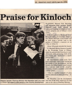
Drawing - Newspaper clipping, Praise for Kinloch, Diamond Valley News, April 8, 1998, p11, April 1998
... He said Kinloch could easily have been subdivided, with a court running up the middle of the development, but the owners, the Jelbart family, opted instead for a private road on the property, sweeping around a common pond and 'village green'. ''This is a perfect example of what can be achieved in urban planning,'' he said. ...He said Kinloch could easily have been subdivided, with a court running up the middle of the development, but the owners, the Jelbart family, opted instead for a private road on the property, sweeping around a common pond and 'village green'. ''This is a perfect example of what can be achieved in urban planning,'' he said. ...PLANNING Minister Rob Maclellan and Nillumbik Shire president Robert Marshall have both praised an innovative housing development on a historic property east of Eltham's town centre. Both were present at the launch of the Kinloch Gardens development, where 12 new double and triple storey homes will be built along a private road in the gardens of Kinloch, a mansion set on 2.4ha in Arthur St. About 100 people attended the launch. Cr Marshall likened Kinloch Gardens to the Woodridge Estate at Eltham, which he said provided housing on small allotments while protecting much of the tree canopy, and "showed how a suburb can be built". He said Kinloch could easily have been subdivided, with a court running up the middle of the development, but the owners, the Jelbart family, opted instead for a private road on the property, sweeping around a common pond and 'village green'. ''This is a perfect example of what can be achieved in urban planning,'' he said. Mr Maclellan said the development was one of the most impressive he had seen in his role as Planning Minister Picture - Historic launch: Planning Minister Rob Maclellan (left) on a visit to Eltham last week to help launch a new housing development.Digital file only; created from scan undertaken by EDHS of item on loanarthur street, eltham, graeme gunn, houses, ian jelbart, jelbart property, kinloch gardens, rob maclellan, robert marshall, woodridge estate -
 Warrnambool and District Historical Society Inc.
Booklet - Booklet Collection: City of Warrnambool Tourist Guides, Collett, Bain and Gaspar, Warrnambool
... The glossy front cover has blue printing with a coloured photo of Flagstaff Hill Maritime Village pond. The centre pages has a fold out map of the City of Warrnambool. ...The glossy front cover has blue printing with a coloured photo of Flagstaff Hill Maritime Village pond. The centre pages has a fold out map of the City of Warrnambool. ...This is a collection of sixteen tourist guides dating from the mid 1970's to 2013. These contain listings of businesses, accommodation, eateries and events in Warrnambool and district. They also include maps of Warrnambool and surrounds, advertising and photographs of various attractions. While mainly covering Warrnambool a small number of the guides cover the South West Region. These directories have mainly been published by the Warrnambool City Council and are a selection of the types of information provided to visitors at the Tourist information centre during this time period.These tourist guides give snapshots of the City of Warrnambool for the years covered and will be useful for research.[.1] An 8 page paper booklet with black printing and a black & white photo of the pond at the Botanical Gardens on the front cover. [.2] two photocopied A4 black and white pages from the book "On the Trail" K Winser 1956 (Main Roads of Australia) [.3] A trifold colour brochure with a stylised map of the coast on the yellow and blue front cover. The inside has stylised colour drawings on Warrnambool attractions. The rear cover has coloured photographs of bush, Liebig Street and Fletcher Jones gardens [.4] A trifold black and white brochure with a black line drawing of a whale on the front cover. [.5] A trifold white card with mauve printing. The front cover has a line drawing of the former Timor Street post office and a map of businesses and landmarks in Timor Street. The reverse side contains a brief history of Warrnambool. [.6] A 98 page stapled booklet with a foreword by Vanda Savill. There are 4 pages of coloured photographs. The remainder are black and white photographs. The front cover is purple with white writing in the lower third. There is an outline of the coast and five colour photographs of district attractions. The inside middle page has a map of the Western wonderland region. The content covers towns in this area. Content relating to Warrnambool is in the last six pages. [.7] Twelve loose photocopied black and white pages. The front cover has the Warrnambool Premier Town 1988-1991 logo and a photo of a Southern Right Whale and calf. The bottom right hand corner has a Standard Warrnambool logo. [.8] 44 page booklet printed with blue ink. The staples have been removed. The glossy front cover has blue printing with a coloured photo of Flagstaff Hill Maritime Village pond. The centre pages has a fold out map of the City of Warrnambool. The rear cover has photos of The Twelve Apostles and Hopkins Falls. [.9] 4 loose photocopied pages with Warrnambool Library and Corangamite Regional Library Service Warrnambool City Library black ink stamps. The front page line drawing illustrations of Warrnambool attractions [.10] A single sheet of glossy white paper folded in half to make four pages. The front page has a Warrnambool premier town logo 1979-1982 and blue printing and a visitor survey. [.11] A conference pack of light card folded to make a pocket containing three brochures, a shipwreck coast tourist directory and a Australian Heritage Parks Association conference program dated 24 to 27 May 1992. The front cover of the pack has green writing over a stylised upward arrow. There is a City of Warrnambool logo in the top right hand corner and two film strips diagonally across the cover containing photographs of Warrnambool. The rear cover has a coloured Warrnambool Premier Town logo. [.12] A 63 page stapled booklet with coloured photographs of Warrnambool. The front cover has black writing on white background. There is a coloured photograph of Flagstaff Hill in the middle of the cover and a Warrnambool City and Visit Victoria logos on the lower edge. The middle pages has a coloured of the city of Warrnambool with an inset map of Allansford. [.13] A single large sheet of white paper folded in ten to make a brochure. The front cover has black printing. The rear cover has a purple ink stamp for the City of Warrnambool Tourist Information Centre. When folded out the reverse side has a green, grey and white map of the South West Region of Victoria. [.14] A 48 page colour booklet on glossy paper. The front cover has white writing on a blue background and includes photographs of the Twelve Apostles, the Promenade walk, Flagstaff Hill and a southern right whale's tail. The rear cover has photographs of The Twelve apostles, a passenger train from Melbourne passing the Lake Pertobe playground, and a rural scene. There is white writing and a white Warrnambool City logo on a blue background. The centre pages have a stylised green and blue map of the city of Warrnambool. [.15] A 48 page colour booklet on glossy paper. The front cover has white writing over colour photographs of two people at a lookout, Flagstaff Hill, three southern right whales and a child at the Lake Pertobe playground. The lower edge has blue upper case writing on a white background. The rear cover has a colour photograph of the Twelve Apostles. The lower white border on the rear covers has a a blue and green City of Warrnambool logo and blue writing. The centre pages have a stylised green and blue map of the city of Warrnambool. [.16] A 64 page colour booklet on glossy paper. The front cover has black writing on a black background and there is a photograph of a southern right whale's tail. The lower edge has the Warrnambool City and Visit Victoria Logos. The centre pages have maps of Warrnambool and surrounds. [.1] This week in Warrnambool Vol 2 No. 5 Thurs 1st Feb. For the time of your life [.2] Warrnambool Way [.3] Warrnambool The Holiday Host on the South West Coast with compliments City of Warrnambool and Warrnambool Chamber of Commerce [.4] MMI Insurance presents Whales Giants of the Deep Whale Watcher's Logbook Warrnambool [.5] Warrnambool History began in Timor Street [.6] Western Wonderland Tourist Association [.7] A Premier Arrow Tour of Warrnambool Victoria's Premier Town Australia's Southern Right Whale Nursery [.8] Warrnambool The Heart of Victoria's Great Southwest Visitor's Handbook [.9] What to see in Warrnambool Victoria's Premier City 1979-1982 [.10] Win a Free Holiday & $200 Cash in Victoria's Premier Town [.11] Advancing Warrnambool together! [.12] Great Ocean Road Warrnambool Official Visitor Guide [.13] Tourist guide to the South West Region Victoria All it needs is you [.14] Warrnambool visitor guide 2005 the great ocean road experience attractions accommodation entertainment dining [.15] Warrnambool Visitor Guide 2006 the great ocean road experience Attractions Accommodation Entertainment Dining [.16] Official Visitors' Guide Warrnambool Victoria Australia Discover the Great Ocean Road warrnambool, warrnambool tourist guides -
 Flagstaff Hill Maritime Museum and Village
Vehicle - Furphy Water Cart, J. Furphy & Sons, c. 1942
... Flagstaff Hill Maritime Museum and Village 89 Merri Street Warrnambool great-ocean-road This horse-drawn, two-wheeled cart with a tank, is known as a Furphy Farm Water Cart that was made in Shepparton, northern Victoria, c. 1942. John Furphy (1842-1920) was born in Moonee Ponds ...This horse-drawn, two-wheeled cart with a tank, is known as a Furphy Farm Water Cart that was made in Shepparton, northern Victoria, c. 1942. John Furphy (1842-1920) was born in Moonee Ponds, in 1842 to Irish immigrant parents and subsequently raised in the Yarra Valley before the family moved to Kyneton in central Victoria, where he completed an apprenticeship with the firm Hutcheson and Walker. Murphy began operations of his own at a site on Piper Street in Kyneton in 1864. He relocated for a business opportunity and founded the first blacksmiths and wheelwrights shop in the newly surveyed town of Shepparton in 1873. Furphy invented many farming tools and machines including a patented grain-stripper, and won awards at the 1888-89 Melbourne International Exhibition. His most famous invention is the Furphy Farm Water Cart, designed in the 1880s, at a time when water for most households and farms was carted on wagons in wooden barrels. The Furphy’s water cart is a single item that combines a water metal tank and a cart. The design of the cart was simple yet effective, and became popular very quickly and established itself as a vital piece of farming equipment. The water cart has had a number of words cast into its ends over many years. References to the foundry’s location in Shepparton, as well as advertising of other products also manufactured by J. Furphy & Sons were present on the ends. However, the most significant set of words to feature on the tank, was a poem encouraging continual improvement: ‘Good Better Best, Never Let it Rest, Until your Good is Better, And your Better Best’. During The Great War (1914-1918), the water cart was used by the Australian militarily at a large AIF (Australian Imperial Force) camp in Broadmeadows (Melbourne) where thousands of men were camped for months, before being transported aboard. Furphy Water Carts provided water to the troops, and were usually placed near the camp latrines, which was one of the few places the troops could share gossip and tall tales away from the prying eyes and ears of their officers. The water cart drivers were also notorious sources of information, despite most of their news being hearsay, or totally unreliable. By the time the men of the AIF were in engaged in combat on the Gallipoli Peninsula and the Western Front, the carts used for water supply had no markings and became simply referred to as Furphys. This owed as much to the coining of the term ‘Furphy’, Australian slang for suspect information or rumour. After a number of decades as principally a soldier’s word, 'Furphy' entered the broader Australian vernacular and was used mainly by the political class until recently when the term was taken up by a Australian brewer as a beer brand. This Furphy Water Cart was purchased by Friends of Flagstaff Hill in 2014. The support of local individuals, organisations and businesses enabled its restoration and later its installation alongside the existing late-19th century water pipe stand and 1940s hand pump The Furphy Farm Water Cart is of historical significance as it represents a famous Australian time-saving and energy-saving invention of the 1880s, replacing the labour intensive activity of collecting and dispensing water from barrels and casks on the back of carts. The water cart’s connection with manufacturing companies J. Furphy & Sons and Furphy Foundry are significant for being early Australian businesses that are still in operation today. Furphy carts are of military significance for the role they played during The Great War (1914-1918) in Australian army camps, and theatres of war in Europe and the Middle East, to supply the AIF troops with fresh water. A wooden framed, two-wheeled, horse-drawn cart, fitted with a horizontally mounted, cylindrical metal tank. The tank is made of rolled, sheet steel with a riveted seam, and cast iron ends with cast iron ends. The spoked metal wheels have fitted flat iron tyres and metal hubs. A metal pipe is joined to the outlet. The tank is silver coloured, the ends, wheels and trims are crimson, and the script lettering on tank sides is black. There are inscriptions on the tank, ends, and hubs. The water tank was made in 1942 in Shepparton, Australia, by J. Furphy & Sons and has a capacity of 180 gallons (848 litres). Hub perimeter, embossed “J. FURPHY & SONS” “KEEP THE / BOLTS TIGHT” Hub centre embossed [indecipherable] Tank, each side, painted “J. FURPHY & SONS / Makers / SHEPPARTON” Tank ends, embossed – “FURPHY’S FARM WATER CART” “BORN ABOUT 1880 – STILL ‘GOING STRONG’ 1942” “j. FURPHY & SONS / MAKERS / SHEPPARTON - VIC “ “S - - - - - L MANUFACTURERS” [SPECIAL] “SPIKE ROLLERS” “SINGLE TREES” “PLOUGH WHEELS” “IRON CASTINGS” “LAND GRADERS” “STEEL DELVERS” “CAST IRON PIG” “CHAIN YOKES” “GOOD – BETTER – BEST / NEVER LET IT REST / TILL YOUR GOOD IS BETTER / AND YOUR BETTER – BEST” Image [Stork carrying a baby] above shorthand, transcribed "Produce and populate or perish" Image [Furphy Pig Feeder] beside ‘Cast Iron Pig’ Shorthand, transcribed “"Water is the gift of God but beer and whiskey are concoctions of the Devil, come and have a drink of water"warrnambool, flagstaff hill maritime museum, water cart, furphy cart, furphy tank, furphy farm water cart, furphy, john furphy, john furphy & sons, furphy foundry, kyneton, shepparton, mobile water tank, jinker, hutchinson & walker, blacksmith, farm equipment, implement maker, tool maker, horse drawn, stork and baby, good, better, best, barrel, tank, first world war, wwi, eastern front, gallipoli, j furphy & sons -
 Flagstaff Hill Maritime Museum and Village
Book, Wool Wool Cookery Book
... Recently Mrs Roger Pearce, formerly Lorraine Snell, who is married to a great grandson of Bessie Neill, thought it fitting that the book should be returned to this locality, and sent it to her mother, Mrs Mary Snell. flagstaff hill warrnambool shipwrecked-coast flagstaff-hill flagstaff-hill-maritime-museum maritime-museum shipwreck-coast flagstaff-hill-maritime-village wool wool cookery book book glenample homestead inside cover has hand writting Bessie Keill, "Merkeering" (W), 27 Browning Street, Moonee Ponds. ...The book belonged to Mrs Bessie Neil, a daughter of Mr and Mrs William McKenzie who came from Scotland, possibly in the 1860s, and were employed at Glenample station, near Port Campbell. In about 1905, the Neills moved to South Africa, and the cookery book went with them. Recently Mrs Roger Pearce, formerly Lorraine Snell, who is married to a great grandson of Bessie Neill, thought it fitting that the book should be returned to this locality, and sent it to her mother, Mrs Mary Snell. Wool Wool Cookery Book Publisher F W Cheshire Printed in Camperdown by the Camperdown Chronicle 1903 inside cover has hand writting Bessie Keill, "Merkeering" (W), 27 Browning Street, Moonee Ponds. March 16th 04 flagstaff hill, warrnambool, shipwrecked-coast, flagstaff-hill, flagstaff-hill-maritime-museum, maritime-museum, shipwreck-coast, flagstaff-hill-maritime-village, wool wool cookery book, book, glenample homestead -
 Marysville & District Historical Society
Newspaper (Item) - Newspaper article, The Age, POCKET GUIDE TO MARYSVILLE, 22-11-2008
... A newspaper article on Marysville, its local attractions, places to shop and dine, where to stay and ways of traveling to Marysville. marysville victoria australia the age black spur marysville visitor information centre steavenson falls lady talbot drive taggerty river keppel falls phantom falls beeches rainforest walk cambarville yarra ranges national park the big tree cumberland walk lake mountain steavenson river acheron river buxton bait and tackle marysville trout and salmon ponds buxton trout and salmon farm bruno's art and sculpture garden villa day spa cathedral view natural therapies marysville massage murchison street village walk uncle fred & aunty val's old style lolly shop country touch gallery manical mechanicals hidden talent craft gallery carmyle farm boutique marysville community market marysville patisserie marysville country bakery fraga's cafe restaurant terracotta room marylands country house the cumberland mantirri blueberry farm narbethong marysville farmers market the black spur inn allawah country cottages barree mud brick cottages A newspaper article on Marysville, its local attractions, places to shop and dine, where to stay and ways of traveling to Marysville. ...A newspaper article on Marysville, its local attractions, places to shop and dine, where to stay and ways of traveling to Marysville. This article was published in The Age on Saturday, November 22, 2008.A newspaper article on Marysville, its local attractions, places to shop and dine, where to stay and ways of traveling to Marysville.marysville, victoria, australia, the age, black spur, marysville visitor information centre, steavenson falls, lady talbot drive, taggerty river, keppel falls, phantom falls, beeches rainforest walk, cambarville, yarra ranges national park, the big tree, cumberland walk, lake mountain, steavenson river, acheron river, buxton bait and tackle, marysville trout and salmon ponds, buxton trout and salmon farm, bruno's art and sculpture garden, villa day spa, cathedral view natural therapies, marysville massage, murchison street, village walk, uncle fred & aunty val's old style lolly shop, country touch gallery, manical mechanicals, hidden talent craft gallery, carmyle farm boutique, marysville community market, marysville patisserie, marysville country bakery, fraga's cafe restaurant, terracotta room, marylands country house, the cumberland, mantirri blueberry farm, narbethong, marysville farmers market, the black spur inn, allawah country cottages, barree mud brick cottages -
 Ballarat Heritage Services
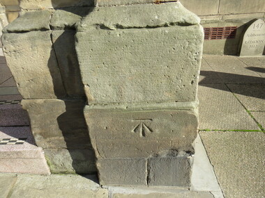
Digital Photograph, Stonemason mark, Ashbourne Town Hall, UK
... The estate village has a number of micro businesses and a beautiful duck pond. Reference: Information from the Ashbourne Tourist pamphlet...The estate village has a number of micro businesses and a beautiful duck pond. Reference: Information from the Ashbourne Tourist pamphlet mason marks Ashbourne Derbyshire market town Francis Fitzherbert Tissington Stonemason mark, Ashbourne Town Hall, UK Digital Photograph ...Ashbourne is one of Derbyshire's fines and most vibrant market towns. It combines a wealth of historic buildings and shops. The Market Place is cobbles with hidden alleys and yards that lead to the carparks behind the main street. The wide and elegant Church Street is considered to be the finest street of Georgian buildings in Derbyshire. Tissington Hall and Village are in the nearby vicinity. Built by Francis Fitzherbert in 1609 Tissington Hall has been lived in by the Fitzherbert family ever since. The estate village has a number of micro businesses and a beautiful duck pond. Reference: Information from the Ashbourne Tourist pamphletmason marks ashbourne derbyshire market town francis fitzherbert tissington -
 Ballarat Heritage Services
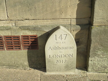
Digital Photograph, Milestone, Ashbourne, UK
... The estate village has a number of micro businesses and a beautiful duck pond. Reference: Information from the Ashbourne Tourist pamphlet...The estate village has a number of micro businesses and a beautiful duck pond. Reference: Information from the Ashbourne Tourist pamphlet Milestone, Ashbourne, UK Digital Photograph ...Ashbourne is one of Derbyshire's fines and most vibrant market towns. It combines a wealth of historic buildings and shops. The Market Place is cobbles with hidden alleys and yards that lead to the carparks behind the main street. The wide and elegant Church Street is considered to be the finest street of Georgian buildings in Derbyshire. Tissington Hall and Village are in the nearby vicinity. Built by Francis Fitzherbert in 1609 Tissington Hall has been lived in by the Fitzherbert family ever since. The estate village has a number of micro businesses and a beautiful duck pond. Reference: Information from the Ashbourne Tourist pamphlet -
 Ballarat Heritage Services
Digital photograph, Sign, Ashbourne, UK
... The estate village has a number of micro businesses and a beautiful duck pond. Reference: Information from the Ashbourne Tourist pamphlet...The estate village has a number of micro businesses and a beautiful duck pond. Reference: Information from the Ashbourne Tourist pamphlet Ashbourne Derbyshire Church St Francis Ftizherbert market town Georgian Tissington Green Man and Black's Head Royal Hotel Sign, Ashbourne, UK Digital photograph ...Ashbourne is one of Derbyshire's fines and most vibrant market towns. It combines a wealth of historic buildings and shops. The Market Place is cobbles with hidden alleys and yards that lead to the carparks behind the main street. The wide and elegant Church Street is considered to be the finest street of Georgian buildings in Derbyshire. Tissington Hall and Village are in the nearby vicinity. Built by Francis Fitzherbert in 1609 Tissington Hall has been lived in by the Fitzherbert family ever since. The estate village has a number of micro businesses and a beautiful duck pond. Reference: Information from the Ashbourne Tourist pamphletGreen Man and Black's Head Royal Hotelashbourne derbyshire church st francis ftizherbert market town georgian tissington -
 Ballarat Heritage Services
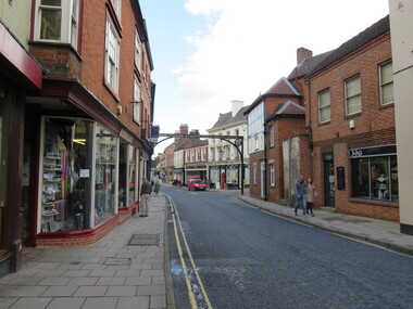
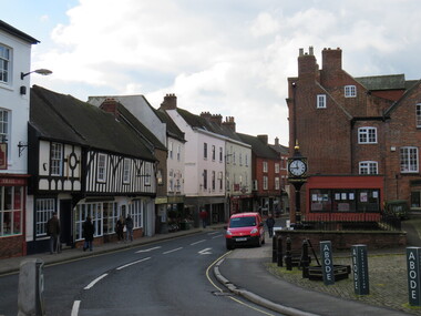
Digital Photograph, Ashbourne, UK
... The estate village has a number of micro businesses and a beautiful duck pond. Reference: Information from the Ashbourne Tourist pamphlet...The estate village has a number of micro businesses and a beautiful duck pond. Reference: Information from the Ashbourne Tourist pamphlet Ashbourne, UK Digital Photograph ...Ashbourne was the village of an historical event. At Ashbourne on 3 December 1745 Charles Edward Stuart declared his father James King of England, Wales and Scotland. Ashbourne is one of Derbyshire's fines and most vibrant market towns. It combines a wealth of historic buildings and shops. The Market Place is cobbles with hidden alleys and yards that lead to the carparks behind the main street. The wide and elegant Church Street is considered to be the finest street of Georgian buildings in Derbyshire. Tissington Hall and Village are in the nearby vicinity. Built by Francis Fitzherbert in 1609 Tissington Hall has been lived in by the Fitzherbert family ever since. The estate village has a number of micro businesses and a beautiful duck pond. Reference: Information from the Ashbourne Tourist pamphlet -
 Ballarat Heritage Services
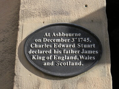
Digital Photograph, Plaque, Ashbourne, UK
... The estate village has a number of micro businesses and a beautiful duck pond. Reference: Information from the Ashbourne Tourist pamphlet...The estate village has a number of micro businesses and a beautiful duck pond. Reference: Information from the Ashbourne Tourist pamphlet king james ashbourne At Ashbourne on December 3rd 1745, Charles Edward Stuart declared his father James King of England, Wales and Scotland. ...Ashbourne is one of Derbyshire's fines and most vibrant market towns. It combines a wealth of historic buildings and shops. The Market Place is cobbles with hidden alleys and yards that lead to the carparks behind the main street. The wide and elegant Church Street is considered to be the finest street of Georgian buildings in Derbyshire. Tissington Hall and Village are in the nearby vicinity. Built by Francis Fitzherbert in 1609 Tissington Hall has been lived in by the Fitzherbert family ever since. The estate village has a number of micro businesses and a beautiful duck pond. Reference: Information from the Ashbourne Tourist pamphletAt Ashbourne on December 3rd 1745, Charles Edward Stuart declared his father James King of England, Wales and Scotland.king james, ashbourne -
 Flagstaff Hill Maritime Museum and Village
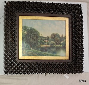
Decorative object - "Crown of Thorns" picture frame, 19th Century
... Flagstaff Hill Maritime Museum and Village Warrnambool Great Ocean Road painting oil painting framed painting Henry Pember Smith frame Crown of Thorns frame Crown of Thorns tramp art puzzle frame woodwork A print of an oil painting showing a pond or stream with a fisherman in a boat. ...This print appears to be a copy of an oil painting by the American painter "Henry Pember Smith" (1854 - 1907) who was well known for depicting ocean and countryside views around the states of Connecticut, Maine, Rhode Island and New Jersey. It has been inserted into an intricate frame made from hundreds of interlocking slender pieces of wood that are self-supporting - without using glue or nails. This skillfully executed technique is called "Crown of Thorns" - sometimes known as "tramp art" in the U.S. or "puzzle frames". The technique was used to embellish an object such as (in this case) a frame or a box or furniture. The maker and age is unknown. This frame is highly significant due to it's rarity and the skill of the unknown craftsman who constructed it.A print of an oil painting showing a pond or stream with a fisherman in a boat. Trees, shrubs and a building are in the background. Two ducks and a tree are in the foreground. It has a glass front with a gold inner frame and is on a wooden back with diagonal struts for reinforcement. The paper backing is fragile and damaged. The print has been inserted into a spiky wooden frame made in the "Crown of Thorns" style using hundreds of interlocking pieces of wood. Some of the pieces have fallen out. Wire has been attached to the back.flagstaff hill maritime museum and village, warrnambool, great ocean road, painting, oil painting, framed painting, henry pember smith, frame, crown of thorns frame, crown of thorns, tramp art, puzzle frame, woodwork