Showing 3 items matching "volcanic grasslands"
-
 Ballarat Heritage Services
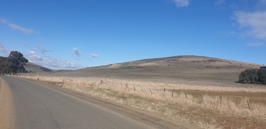
Photograph - Colour Photograph, Clare Gervasoni, Mount Greenock, 2025, 28/06/2025
... ...volcanic grasslands...Mt Greenock Mount Greenock mining mullock heap Mt Greenock Geological Reserve Union Mine volcanic grasslands Dunach Colour Photographs of Mt Greenock, near Talbot, Victoria. ...Mt Greenock is an extinct volcano with lava flows associated with a deep lead. It is a tall scoria cone with a broad shallow crater open to the northwest. In the crater are blocks and bombs of scoriaceous basalt. Long lava flows extend both north and south from the cone. It is considered a significant geological site, and part of the Major Mitchell Trail, with a 1936 ‘Centenary of Major Mitchell ‘monument on the summit. The flow to the north has been eroded by McCallum Creek which is a lateral stream. On the eastern base of the cone, the stream valley exposes a lava flow and underlying sedimentary rocks. The lava flow and the scoria cone overlie the Greenock lead (a buried valley with auriferous gravels). A line of mine tailing and abandoned mining relics associated with the former Union Mine occur on the margins of the lava flow. Mount Greenock is a 120 hectare ‘Geological Reserve’, is one of the few large scoria cones on public land and contains abundant outcrop and morphological evidence of its volcanic origin. Colour Photographs of Mt Greenock, near Talbot, Victoria. The photographs were taken in winter not long after the first post drought rains. Mt Greenock was climbed by Major Thomas Mitchell on 26 September 1936, and he gave it the current name. At that time the mount was part of Alexander McCallum's Dunach Forest Pastoral Run.mt greenock, mount greenock, mining, mullock heap, mt greenock geological reserve, union mine, volcanic grasslands, dunach -
 Ballarat Heritage Services
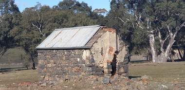
Photograph - Colour Photograph, Clare Gervasoni, Built Remains near Mount Greenock, 2025, 28/06/2025
... ...volcanic grasslands...Mt Greenock Mount Greenock mining mullock heap Mt Greenock Geological Reserve Union Mine volcanic grasslands Dunach Colour Photographs of bluestone and brick buildings at Mt Greenock, near Talbot, Victoria. ...Mt Greenock is an extinct volcano with lava flows associated with a deep lead. It is a tall scoria cone with a broad shallow crater open to the northwest. In the crater are blocks and bombs of scoriaceous basalt. Long lava flows extend both north and south from the cone. It is considered a significant geological site, and part of the Major Mitchell Trail, with a 1936 ‘Centenary of Major Mitchell ‘monument on the summit. The flow to the north has been eroded by McCallum Creek which is a lateral stream. On the eastern base of the cone, the stream valley exposes a lava flow and underlying sedimentary rocks. The lava flow and the scoria cone overlie the Greenock lead (a buried valley with auriferous gravels). A line of mine tailing and abandoned mining relics associated with the former Union Mine occur on the margins of the lava flow. Mount Greenock is a 120 hectare ‘Geological Reserve’, is one of the few large scoria cones on public land and contains abundant outcrop and morphological evidence of its volcanic origin. Colour Photographs of bluestone and brick buildings at Mt Greenock, near Talbot, Victoria. The photographs were taken in winter not long after the first post drought rains. mt greenock, mount greenock, mining, mullock heap, mt greenock geological reserve, union mine, volcanic grasslands, dunach -
 Hume City Civic Collection
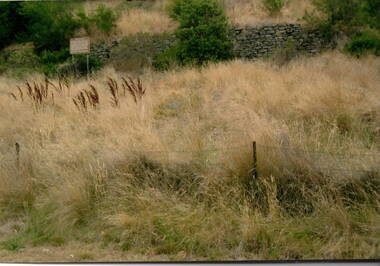
Photograph, The Terraces, 1980s
... volcanic soil and temperate climate were ideal for grape growing. Terraces Vineyards Goonawarra James Goodall Francis A coloured photograph of a stone wall with a notice to the left of the wall and long dried grassland in the front. ...The stone wall is part of the terraces that were built into the hillside at the winery at Goonawarra. They were constructed in the early days when the vineyard was established to terrace the hillside for growing vines. The winery was originally established by Joh Goodall Francis, a former member of the Victorian Legislative Assembly. He acquired a parcel of crown land and proceeded to develop it as a vineyard. The terraces were built by vignerons, who were employed to work on the property. Goonawarra Winery was one of a number of vineyards that were established in the Sunbury area in the 1800s. The volcanic soil and temperate climate were ideal for grape growing.A coloured photograph of a stone wall with a notice to the left of the wall and long dried grassland in the front. A barbed wire fence is in the foreground.terraces, vineyards, goonawarra, james goodall francis