Showing 14 items matching "watchtower"
-
 Federation University Historical Collection
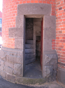
Photograph - Photograph - Colour, Ballarat Gaol Watchtower, 2007, 2007
... Ballarat Gaol Watchtower, 2007......watchtower...The Ballarat Gaol wall, watchtower, wardens residence and Governors Residence are now part of the University of Ballarat's Ballarat School of Mines (SMB) Campus...Photographs of the watchtower at the former Ballarat Gaol, including views from the top of the tower. ...Barker Library (top floor) Mount Helen goldfields The Ballarat Gaol wall, watchtower, wardens residence and Governors Residence are now part of the University of Ballarat's Ballarat School of Mines (SMB) Campus ballarat gaol ballarat school of mines watchtower gaol bluestone Photographs of the watchtower at the former Ballarat Gaol, including views from the top of the tower. ...The Ballarat Gaol wall, watchtower, wardens residence and Governors Residence are now part of the University of Ballarat's Ballarat School of Mines (SMB) CampusPhotographs of the watchtower at the former Ballarat Gaol, including views from the top of the tower. ballarat gaol, ballarat school of mines, watchtower, gaol, bluestone -
 Federation University Historical Collection
Photograph, Ballarat Gaol Watchtower, 1995
... Ballarat Gaol Watchtower......watchtower...Photograph of a man behind bars in the Ballarat watchtower entrance. ...Ballarat Gaol Watchtower Photograph ...Photograph of a man behind bars in the Ballarat watchtower entrance. ballarat school of mines, ballarat gaol, watchtower -
 Federation University Historical Collection
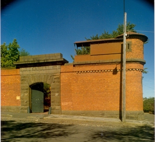
Photograph - Photograph - Colour, Former Ballarat Gaol Gate and Tower, c2000
... Next to the gate is a watchtower with guard walk on top of the brick wall. ...Colour photograph of the former Ballarat Gaol Gate and watchtower taken c2000. Structure built from red brick and locally quarried basalt. ...Next to the gate is a watchtower with guard walk on top of the brick wall. ...The gate shown in the photograph is located on the same wall as the large double main gate of the former Ballarat Gaol. Next to the gate is a watchtower with guard walk on top of the brick wall. This corner location provided the guards with a clear view into the gaol grounds and the street outside. Most of the gaol was demolished to allow for the School of Mines to expand. This watchtower remains along with the main gate, Warden's Quarters and the Governor's residence. These buildings are now used by Federation University Ballarat.Colour photograph of the former Ballarat Gaol Gate and watchtower taken c2000. Structure built from red brick and locally quarried basalt. Guards walk on top of wall from tower to gate was corrugated iron. This smaller gate was to the right of the Warden's Quarters on the same wall as the main double gates to the gaol.ballarat gaol, ballarat gaol gates, ballarat gaol watchtower, ballarat school of mines, federation university, warden's quarters, governor's residence, guard's walk, lydiard street south -
 Phillip Island and District Historical Society Inc.
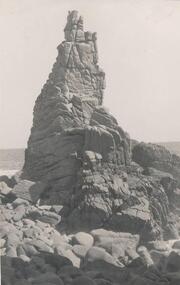
Photograph, Bryant West
... Photograph of Rock Formation, Cape Woolamai - The Watchtower....Phillip Island and District Historical Society Inc. phillip-island-and-the-bass-coast One of a collection of over 400 photographs in an album commenced in 1960 and presented to the Phillip Island & Westernport Historical Society by the Shire of Phillip Island local history photography photographs coastline cape woolamai rock formations phillip island the watch tower cliffs the watch tower cape woolamai john jenner bryant west Photograph of Rock Formation, Cape Woolamai - The Watchtower. Photograph Bryant West ...One of a collection of over 400 photographs in an album commenced in 1960 and presented to the Phillip Island & Westernport Historical Society by the Shire of Phillip IslandPhotograph of Rock Formation, Cape Woolamai - The Watchtower.local history, photography, photographs, coastline, cape woolamai, rock formations, phillip island, the watch tower cliffs, the watch tower cape woolamai, john jenner, bryant west -
 Ballarat Fire Brigade
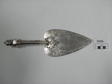
Trowel, just prior to 01/01/1864
... ...watchtower...Trowel was presented to Captain Spark by honourable secretary Mr Charles Dyte on 1/1/1864 to lay the foundation stone of the watchtower and belfrey of the Ballarat fire station. ...Ballarat Fire Brigade Corner Barkly & East Streets Ballarat East goldfields Trowel was presented to Captain Spark by honourable secretary Mr Charles Dyte on 1/1/1864 to lay the foundation stone of the watchtower and belfrey of the Ballarat fire station. ...Trowel was presented to Captain Spark by honourable secretary Mr Charles Dyte on 1/1/1864 to lay the foundation stone of the watchtower and belfrey of the Ballarat fire station. Trowel was made by Mr. Bennett of Bridge street and fashioned on the trowel used by Mr. Fraser M.L.C. when laying the foundation stone of the St. Kilda town hallhand engraved sterling silver ceremonial trowel. engraving is floral design on blade. handle is hollow, octaganol with leaf pattern and greek meander patternHallmarked on underside - emu, "WE" (letters), kangarooballarat fire brigade, captain, foundation stone, trowel, colonial silversmith, silver trowel, captain spark, honourable secretary, mr bennet, sterling silver, charles dyte, dyte, spark, 1864, watchtower and belfrey, tower, watchtower, belfrey -
 Halls Gap & Grampians Historical Society
Photograph - Sepia, c 1876
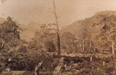
... Photo is of Delley's home with the " Watchtower�" in the background. Further information see "Bridging The Gap" p13-14,17,22,54. ...Halls Gap & Grampians Historical Society Centennial Hall 117-119 Grampians Road Halls Gap grampians Photo is of Delley's home with the " Watchtower�" in the background. Further information see "Bridging The Gap" p13-14,17,22,54. ...Photo is of Delley's home with the " Watchtower�" in the background. Further information see "Bridging The Gap" p13-14,17,22,54. Records 544 & 545 are enlarged portions of this photo.Photo shows old house to right side of photo. There are two chimneys and the lower half of the house is obscured by a stick fence and undergrowth. The mountain range can be seen faintly in the distance. A dead tree can be seen middle foreground. buildings, houses -
 Federation University Historical Collection
Plans, Ballarat Gaol, 1860, 1907, 1960
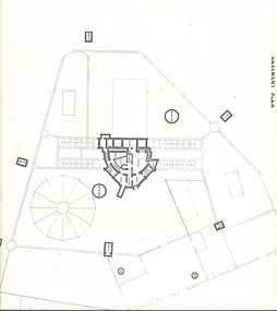
... ...watchtower...Barker Library (top floor) Mount Helen goldfields ballarat gaol ballarat school of mines watchtower gaol gates governor's residence warden's residence Copies of ground floor and first floor plans of Ballarat Gaol Ballarat Gaol Plans Department of Public Works Victoria ...Copies of ground floor and first floor plans of Ballarat Gaol ballarat gaol, ballarat school of mines, watchtower, gaol gates, governor's residence, warden's residence -
 Federation University Historical Collection
Plans, Ballarat Gaol Plans, Watchtowers, Soil Tank, Elevations of walls, Ground Plans, etc, 1860, 1907, 1960
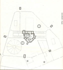
... ...watchtower...Barker Library (top floor) Mount Helen goldfields ballarat gaol ballarat school of mines watchtower gaol gates governor's residence warden's residence Seven copies of of ground floor and first floor plans of Ballarat Gaol, including aerial vier Ballarat Gaol Plans, Watchtowers, Soil Tank, Elevations of walls, Ground Plans, etc Plans Department of Public Works Victoria ...Seven copies of of ground floor and first floor plans of Ballarat Gaol, including aerial vierballarat gaol, ballarat school of mines, watchtower, gaol gates, governor's residence, warden's residence -
 Federation University Historical Collection
Plans, Ballarat Gaol Plans, 1860, 1907, 1960
... ...watchtower...Barker Library (top floor) Mount Helen goldfields ballarat gaol ballarat school of mines watchtower gaol gates governor's residence warden's residence Copies of ground floor and first floor plans of Ballarat Gaol Ballarat Gaol Plans Plans Department of Public Works Victoria ...Copies of ground floor and first floor plans of Ballarat Gaol ballarat gaol, ballarat school of mines, watchtower, gaol gates, governor's residence, warden's residence -
 Ballarat Tramway Museum
Photograph - SECV Geelong 18 in Pakington St Newtown, early 1950s early 1950s
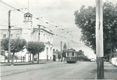
... Photo of SECV Geelong No. 18 in Pakington St, outside the City of Newtown Chilwell Town Hall and fire station, with its watchtower. The tram has the destination of Chilwell, which requires it to swing out to its left. ...Photo of SECV Geelong No. 18 in Pakington St, outside the City of Newtown Chilwell Town Hall and fire station, with its watchtower. The tram has the destination of Chilwell, which requires it to swing out to its left. ...Photo of SECV Geelong No. 18 in Pakington St, outside the City of Newtown Chilwell Town Hall and fire station, with its watchtower. The tram has the destination of Chilwell, which requires it to swing out to its left. The track design was to avoid collisions with incoming cars from Newtown. Shows the overhead at this junction and the tram stop signs in the background. The tram has been fitted with tail lights, photo early 1950s. Photographer unknown.Yields information about Geelong tram18, Pakington St and the junction between the Chilwell and Newtown tram lines.Black and white photograph with printers dates on the rear. Printed on AGFA paper.geelong, tramways, tram 18, newtown, fire station, chilwell, pakington st -
 Warrnambool and District Historical Society Inc.
Functional object - Bookmark, Thomas Stevens, Coventry and London, Mizpah, late 19th century
... The word Mizpah means Watchtower in Hebrew and a Mizpah card or bookmark was sent or given to Jewish people who were separated from their loved ones, with the message that the Lord was watching over those absent. ...The word Mizpah means Watchtower in Hebrew and a Mizpah card or bookmark was sent or given to Jewish people who were separated from their loved ones, with the message that the Lord was watching over those absent. ...This bookmark was found loose inside one of our antiquarian books and no connection to the book or its unknown original owner have been found. The word Mizpah means Watchtower in Hebrew and a Mizpah card or bookmark was sent or given to Jewish people who were separated from their loved ones, with the message that the Lord was watching over those absent. The bookmark has been made by the firm of Thomas Stevens of Coventry. This city was the English centre of ribbon weaving in the 19th century and Thomas Stevens, a local weaver, invented and developed in the 1860s the art of making woven silk items - book marks, greeting cards, art works etc. These were called Stevengraphs. Stevens opened a factory in London in 1878 and by the 1880s was producing over 900 woven silk designs. Stevengraphs are a collectors' Items today and this Mizpah bookmark is a fine example of one.This is a woven silk bookmark with multi-coloured patterns. coloured script and a sprig of fuchsia flowers, all on a yellow background. There is a red tassel at the end of the bookmark. The bookmark was affixed to a rectangular sheet of paper containing details of the maker but the bookmark is now detached. The backing sheet is partly torn.Mizpah The Lord watch between Me and thee when we are Absent one from anotherreligious book marks, stevengraphs -
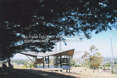 Eltham District Historical Society Inc
Photograph, Fay Bridge, Moor-rul Viewing Platform, Garden Hill, Kangaroo Ground, n.d
... It was built in the style of a Scottish watchtower reflecting the strong Scottish influence of the first European settlers of the district from the 1840s onward. ...It was built in the style of a Scottish watchtower reflecting the strong Scottish influence of the first European settlers of the district from the 1840s onward. ...OPENING OF THE VIEWING PLATFORM AT KANGAROO GROUND Nillumbik Council has advised that the viewing platform at Kangaroo Ground 27km NE of Melbourne is to be opened to the public on Wednesday, March 26th 2008 (Melway 271 , G10). The function of the platform is to provide shelter adjacent to the War Memorial Tower whilst allowing all people to enjoy the stunning panoramic views. From the platform you. can see the Dandenongs, the city of Melbourne, the You Yangs, Mount Macedon, the Kinglake Ranges and the Mt Baw-Baw Ranges where the Yarra River starts. This landscape covers all the ancestral lands of the Wurundjeri and some of the wider Kulin nation land. The platform has been given the name Moor-rut, a name which described the fertile soils of the Kangaroo Ground area in contrast to the poorer (Silurian) country of its surrounds, which the Wurundjeri knew as 'Nillumbik' or less rich country. The full 360 degree view can be seen from the adjacent Tower of Remembrance which has 53 stairs. The viewing platform however can be accessed by wheelchair. Inside the viewing platform there are eight double sided interpretive panels giving the history and information regarding this special area. The viewing platform's interpretive panels set out the Aboriginal and European history of the area and also the geology and the local flora and fauna, so that the casual visitor comes away understanding more about this significant part of Victoria. The concept of the viewing platform is part of the refurbishment project for the Kangaroo Ground War Memorial Park which has taken place since 1997 with the active approval and financial assistance of the Nillumbik Shire Council. This project has been guided by an Advisory Committee with volunteer community representatives from the local Historical Societies, the Country Fire Authority, the Returned Services League and the Wurundjeri people. Other allied groups such as the Nillumbik Reconciliation Group have been called upon for their expertise. The initial idea for the viewing platform came from Dean Stewart when he was the caretaker while living at the park. He discussed this idea with local author Mick Woiwod and Harry Gilham of Eltham District Historical Society when they were planning the refurbishment of the War Memorial Park in 1996. When the committee was formalised by the Nillumbik Council in 1997, Nicholas Pelling, representing the CFA and RSL, joined the group. Dennis Ward, local architect, then volunteered to develop the concept plan for the refurbishment of the park and later drew up the plans for the viewing platform. The Kangaroo Ground War Memorial Park and its Tower of Remembrance is located on one of the highest locations in the Yarra Valley. The Tower of Remembrance is a unique war memorial constructed from local stone standing 14 metres high. It was built in the style of a Scottish watchtower reflecting the strong Scottish influence of the first European settlers of the district from the 1840s onward. The park was opened in 1921 and the Tower of Remembrance was dedicated in 1926 recognising the local people who served in the First World War. Those who served in the Second World War were recognised by plaques dedicated in 1951 and more recently those who served in Korea, Borneo, Malaya and Vietnam by plaques unveiled in 2001. Harry Gilham, Advisory Committee Convenor - Eltham District Historical Society Newsletter N0 179 March 2008fay bridge collection, garden hill, kangaroo ground, memorial park, moor-rul viewing platform -
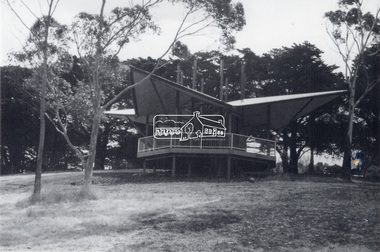 Eltham District Historical Society Inc
Photograph - Black and White Print, Moor-rul Viewing Platform, March 2007
... It was built in the style of a Scottish watchtower reflecting the strong Scottish influence of the first European settlers of the district from the 1840s onward. ...It was built in the style of a Scottish watchtower reflecting the strong Scottish influence of the first European settlers of the district from the 1840s onward. ...Early stages - no display panels installed. OPENING OF THE VIEWING PLATFORM AT KANGAROO GROUND Nillumbik Council has advised that the viewing platform at Kangaroo Ground 27km NE of Melbourne is to be opened to the public on Wednesday, March 26th 2008 (Melway 271 , G10). The function of the platform is to provide shelter adjacent to the War Memorial Tower whilst allowing all people to enjoy the stunning panoramic views. From the platform you. can see the Dandenongs, the city of Melbourne, the You Yangs, Mount Macedon, the Kinglake Ranges and the Mt Baw-Baw Ranges where the Yarra River starts. This landscape covers all the ancestral lands of the Wurundjeri and some of the wider Kulin nation land. The platform has been given the name Moor-rut, a name which described the fertile soils of the Kangaroo Ground area in contrast to the poorer (Silurian) country of its surrounds, which the Wurundjeri knew as 'Nillumbik' or less rich country. The full 360 degree view can be seen from the adjacent Tower of Remembrance which has 53 stairs. The viewing platform however can be accessed by wheelchair. Inside the viewing platform there are eight double sided interpretive panels giving the history and information regarding this special area. The viewing platform's interpretive panels set out the Aboriginal and European history of the area and also the geology and the local flora and fauna, so that the casual visitor comes away understanding more about this significant part of Victoria. The concept of the viewing platform is part of the refurbishment project for the Kangaroo Ground War Memorial Park which has taken place since 1997 with the active approval and financial assistance of the Nillumbik Shire Council. This project has been guided by an Advisory Committee with volunteer community representatives from the local Historical Societies, the Country Fire Authority, the Returned Services League and the Wurundjeri people. Other allied groups such as the Nillumbik Reconciliation Group have been called upon for their expertise. The initial idea for the viewing platform came from Dean Stewart when he was the caretaker while living at the park. He discussed this idea with local author Mick Woiwod and Harry Gilham of Eltham District Historical Society when they were planning the refurbishment of the War Memorial Park in 1996. When the committee was formalised by the Nillumbik Council in 1997, Nicholas Pelling, representing the CFA and RSL, joined the group. Dennis Ward, local architect, then volunteered to develop the concept plan for the refurbishment of the park and later drew up the plans for the viewing platform. The Kangaroo Ground War Memorial Park and its Tower of Remembrance is located on one of the highest locations in the Yarra Valley. The Tower of Remembrance is a unique war memorial constructed from local stone standing 14 metres high. It was built in the style of a Scottish watchtower reflecting the strong Scottish influence of the first European settlers of the district from the 1840s onward. The park was opened in 1921 and the Tower of Remembrance was dedicated in 1926 recognising the local people who served in the First World War. Those who served in the Second World War were recognised by plaques dedicated in 1951 and more recently those who served in Korea, Borneo, Malaya and Vietnam by plaques unveiled in 2001. Harry Gilham, Advisory Committee Convenor - Eltham District Historical Society Newsletter N0 179 March 2008 Black and white inkjet print on paper 14 x 21 cmmoor-rul viewing platform, garden hill, kangaroo ground, memorial park -
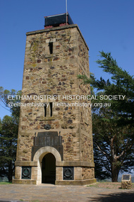 Eltham District Historical Society Inc
Photograph - Digital Photograph, Alan King, Shire of Eltham War Memorial, Kangaroo Ground, 28 January 2008
... The tower is reminiscent of the peel-towers or watchtowers that lined the English-Scottish border from the mid 14th century to around 1600 and is constructed from locally quarried stone. ...The tower is reminiscent of the peel-towers or watchtowers that lined the English-Scottish border from the mid 14th century to around 1600 and is constructed from locally quarried stone. ...The Eltham Shire War Memorial, a tower of remembrance, was built with public donations to commemorate the memory of the fallen soldiers from the shire who enlisted in the 1914-1918 war. The tower is reminiscent of the peel-towers or watchtowers that lined the English-Scottish border from the mid 14th century to around 1600 and is constructed from locally quarried stone. This uncommon and picturesque war memorial, which affords an excellent view of the surrounding district was unveiled by His Excellency the Governor-General (Lord Stonehaven) on November 11, 1926. In July 1922 a deputation of returned soldiers from Panton Hill, presumably the Panton Hill branch of the Returned Sailors and Soldiers Imperial League of Australia (RSSILA), proposed to Eltham Shire Council that the monument should be a cairn of local stone “sufficiently high to form a prominent and conspicuous landmark, and crowned with some suitable device”. Eltham Shire Councillor and President of the Panton Hill branch of the RSSILA, Basil Hall, was credited with being the first to suggest a tower, and with organising a Memorial Park committee to raise funds for the monument in the Memorial Park. A meeting for those interested in the establishing a War Memorial monument in the park was held in January 1924 and the Eltham Shire War Memorial League was formed for this purpose. It appears that the broad and rounded cairn that had been recently built was considered by the League a temporary affair, and not the substantial cairn-as-monument, sufficiently high to form the conspicuous landmark, which had been envisaged by the Panton Hill RSSILA. A design competition was held for the monument. The chairman of the League, Councillor Basil Hall, suggested that the site of the memorial in Kangaroo Ground would lend itself to something rugged, instead of polished stone. By April 1924 thirty designs for a memorial had been received from which three designs were selected and of those, the design by the shire engineer Mr McCormack, for a 70ft tower suitable for construction in rough stone, was chosen. Artist Harold Herbert suggested that a peel tower-like design reminiscent of those along the English-Scottish border would be fitting for the site. Herbert drew up a rough sketch that was approved of, and later, Melbourne architect Percy Meldrum volunteered to draw up the design from sketch to architectural drawings. By January 1925 the Soldiers’ Memorial League had adopted Meldrum’s design for a 50ft high tower. Meldrum had also offered his design and supervision of construction free of charge. The Shire provided the stone to the builders, which was a gift quarried from land owned at Kangaroo Ground by Dr Ethel and Professor William Osborne The Shire of Eltham War Memorial, a tower of remembrance, and honour board were unveiled on November 11, 1926, by the Governor General Lord Stonehaven. At this stage a temporary honour roll was painted on the panels on either side of the tower entrance. In September 1930 bronze plates were added above the portal with the names of men who fell in the 1914-18 war. On November 16, 1951, the Governor of Victoria, Sir Dallas Brooks re-dedicated the war memorial tower and unveiled the names of men who gave their lives in the 1939-45 war. Two additional bronze plaques which recognise service in the armed conflicts of Korea, Borneo, Malaya, and Vietnam were unveiled November 11, 2001, by the Governor of Victoria, John Landy, A.C., M.B.E. The tower was first used for fire spotting activities following the Black Friday bushfire in January 1939 in response to a request from Mr R.D. Ness, secretary of the Kangaroo Ground bush fire brigade, who asked Council that the tower be used as an observation tower for detecting bush fires, and asked Council to arrange a telephone to be installed. It was suggested that if the Shire were to appoint a caretaker for the Memorial Park, his duties could also include raising the alarm in the event of a fire. Later in 1939 Council applied for a radio transmitter, which the Forestry Commission planned to install at vantage places throughout the state. The first dedicated fire spotter appointed from December1948, was Mr Smith of Warrandyte. A prefabricated glazed cabin was installed in 1974, which involved the removal of the original stone structure around the rooftop exit door. A new fire spotting cabin, which included the latest technology, was installed soon after the 2009 Black Saturday fires and is manned by CFA personnel on high fire danger days. Covered under Heritage Overlay, Nillumbik Planning Scheme. Published: Nillumbik Now and Then / Marguerite Marshall 2008; photographs Alan King with Marguerite Marshall.; p123This collection of almost 130 photos about places and people within the Shire of Nillumbik, an urban and rural municipality in Melbourne's north, contributes to an understanding of the history of the Shire. Published in 2008 immediately prior to the Black Saturday bushfires of February 7, 2009, it documents sites that were impacted, and in some cases destroyed by the fires. It includes photographs taken especially for the publication, creating a unique time capsule representing the Shire in the early 21st century. It remains the most recent comprehenesive publication devoted to the Shire's history connecting local residents to the past. While published in the book in black and white, this collection features the original colour digital photographs. nillumbik now and then (marshall-king) collection, garden hill, kangaroo ground, memorial park, shire of eltham war memorial