Showing 219 items matching "water falls"
-
 Malmsbury Historical Society
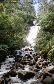
Photograph (Item), Turpins Water Falls, Malmsbury ca1980/90
... Turpins Water Falls, Malmsbury ca1980/90...Malmsbury Historical Society Malmsbury Mechanics Institute 71 Mollison Street Malmsbury daylesford-and-the-macedon-ranges People - "Mitchell, Ron" Turpins Water Falls, Malmsbury ca1980/90 Photograph Photograph ...People - "Mitchell, Ron" -
 Stawell Historical Society Inc
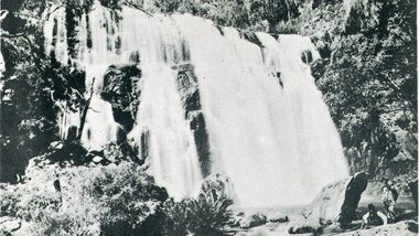
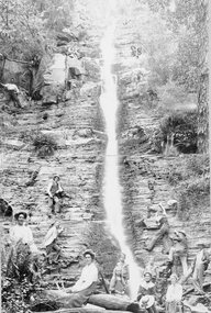
Postcard, Mackenzie Falls in the Grampians -- Postcard
... Black and white view of water falls with 2 people in right corner of photo....Black and white view of water falls with 2 people in right corner of photo. ...Mackenzie Falls The Grampians Series 5106Black and white view of water falls with 2 people in right corner of photo.Mackenzie Falls. Grampians. Series 5106 (copyright).halls gap grampians -
 Stawell Historical Society Inc
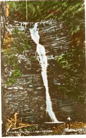
Postcard, Silverband Falls in the Grampians -- Postcard
... Coloured photograph of a very tall water falls on layers of rock formation. A person is standing at the base of the falls....Stawell Historical Society Inc 46 Longfield St Stawell grampians Silverband Falls No 21 The Grampians halls gap grampians Silverband Falls Grampians No 21 Coloured photograph of a very tall water falls on layers of rock formation. A person is standing at the base of the falls. ...Silverband Falls No 21 The GrampiansColoured photograph of a very tall water falls on layers of rock formation. A person is standing at the base of the falls.Silverband Falls Grampians No 21halls gap grampians -
 Eltham District Historical Society Inc
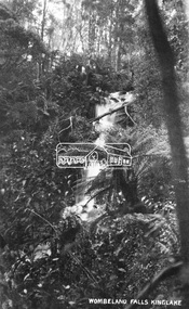
Negative - Photograph, Wombelano Falls, Kinglake
... ...Water Falls...Kinglake National Park Shire of Eltham Pioneers Photograph Collection Water Falls Wombelano Falls Digital image 4 x 5 inch B&W Neg Wombelano Falls, Kinglake Negative Photograph ...Wombelano Falls is framed by a eucalypt forest and lush gullies in the Kinglake National Park. This image probably produced as a postcard.This photo forms part of a collection of photographs gathered by the Shire of Eltham for their centenary project book,"Pioneers and Painters: 100 years of the Shire of Eltham" by Alan Marshall (1971). The collection of over 500 images is held in partnership between Eltham District Historical Society and Yarra Plenty Regional Library (Eltham Library) and is now formally known as 'The Shire of Eltham Pioneers Photograph Collection.' It is significant in being the first community sourced collection representing the places and people of the Shire's first one hundred years.Digital image 4 x 5 inch B&W Negkinglake national park, shire of eltham pioneers photograph collection, water falls, wombelano falls -
 Eltham District Historical Society Inc
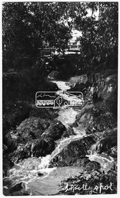
Photograph, Research. "A Pretty Spot."
... ...water falls...It is significant in being the first community sourced collection representing the places and people of the Shire's first one hundred years. sepp shire of eltham pioneers photograph collection research (vic.) water falls Digital image Research. "A Pretty Spot." ...Source: Mrs. E.R. Reynolds, Thompson Crescent, ResearchThis photo forms part of a collection of photographs gathered by the Shire of Eltham for their centenary project book,"Pioneers and Painters: 100 years of the Shire of Eltham" by Alan Marshall (1971). The collection of over 500 images is held in partnership between Eltham District Historical Society and Yarra Plenty Regional Library (Eltham Library) and is now formally known as the 'The Shire of Eltham Pioneers Photograph Collection.' It is significant in being the first community sourced collection representing the places and people of the Shire's first one hundred years.Digital imagesepp, shire of eltham pioneers photograph collection, research (vic.), water falls -
 Eltham District Historical Society Inc
Photograph, Waterfall. Perhaps Research District
... ...water falls...It is significant in being the first community sourced collection representing the places and people of the Shire's first one hundred years. sepp shire of eltham pioneers photograph collection research (vic.) water falls Digital image Waterfall. Perhaps Research District. ...Source: Mrs. E.R. Reynolds, Thompson Crescent, ResearchThis photo forms part of a collection of photographs gathered by the Shire of Eltham for their centenary project book,"Pioneers and Painters: 100 years of the Shire of Eltham" by Alan Marshall (1971). The collection of over 500 images is held in partnership between Eltham District Historical Society and Yarra Plenty Regional Library (Eltham Library) and is now formally known as the 'The Shire of Eltham Pioneers Photograph Collection.' It is significant in being the first community sourced collection representing the places and people of the Shire's first one hundred years.Digital imagesepp, shire of eltham pioneers photograph collection, research (vic.), water falls -
 Eltham District Historical Society Inc
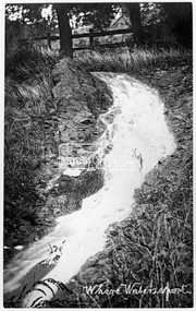
Photograph, "Where Waters Sport" - Perhaps Research
... ...water falls...It is significant in being the first community sourced collection representing the places and people of the Shire's first one hundred years. sepp shire of eltham pioneers photograph collection research (vic.) water falls stream drain water-flow Digital image "Where Waters Sport" - Perhaps Research Photograph Photograph ...Photo of a fast flowing stream or drain, possibly Research Creek, Research, VictoriaThis photo forms part of a collection of photographs gathered by the Shire of Eltham for their centenary project book,"Pioneers and Painters: 100 years of the Shire of Eltham" by Alan Marshall (1971). The collection of over 500 images is held in partnership between Eltham District Historical Society and Yarra Plenty Regional Library (Eltham Library) and is now formally known as the 'The Shire of Eltham Pioneers Photograph Collection.' It is significant in being the first community sourced collection representing the places and people of the Shire's first one hundred years.Digital imagesepp, shire of eltham pioneers photograph collection, research (vic.), water falls, stream, drain, water-flow -
 Eltham District Historical Society Inc
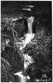
Photograph, "The Waterfall" - Perhaps Research
... ...water falls...It is significant in being the first community sourced collection representing the places and people of the Shire's first one hundred years. sepp shire of eltham pioneers photograph collection research (vic.) water falls Digital image "The Waterfall" - Perhaps Research. ...Source: Mrs. E.R. Reynolds, Thompson Crescent, ResearchThis photo forms part of a collection of photographs gathered by the Shire of Eltham for their centenary project book,"Pioneers and Painters: 100 years of the Shire of Eltham" by Alan Marshall (1971). The collection of over 500 images is held in partnership between Eltham District Historical Society and Yarra Plenty Regional Library (Eltham Library) and is now formally known as the 'The Shire of Eltham Pioneers Photograph Collection.' It is significant in being the first community sourced collection representing the places and people of the Shire's first one hundred years.Digital imagesepp, shire of eltham pioneers photograph collection, research (vic.), water falls -
 Eltham District Historical Society Inc
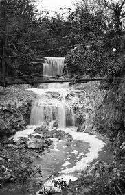
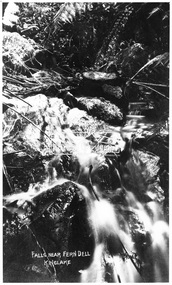
Photograph, Kinglake National Park, falls near Fern Dell, Kinglake, c.1918
... ...water falls...It is significant in being the first community sourced collection representing the places and people of the Shire's first one hundred years. sepp shire of eltham pioneers photograph collection kinglake kinglake national park water falls Digital image Kinglake National Park, falls near Fern Dell, Kinglake, c.1918. ...Source: Mrs. McMinn, Kinglake.This photo forms part of a collection of photographs gathered by the Shire of Eltham for their centenary project book,"Pioneers and Painters: 100 years of the Shire of Eltham" by Alan Marshall (1971). The collection of over 500 images is held in partnership between Eltham District Historical Society and Yarra Plenty Regional Library (Eltham Library) and is now formally known as the 'The Shire of Eltham Pioneers Photograph Collection.' It is significant in being the first community sourced collection representing the places and people of the Shire's first one hundred years.Digital imagesepp, shire of eltham pioneers photograph collection, kinglake, kinglake national park, water falls -
 Eltham District Historical Society Inc
Photograph, Waterfall, c. Nov 1988
... water falls...Eltham District Historical Society Inc 728 Main Rd Eltham melbourne water falls Fuji 100 Roll of 35mm colour negative film, 2 strips Waterfall, c. ...Roll of 35mm colour negative film, 2 stripsFuji 100water falls -
 Marysville & District Historical Society
Postcard (item) - Black and white postcard, Valentine Publishing Co. Pty. Ltd, Steavenson Falls, Marysville V.15, 1923-1963
... VALENTINE'S/ POST CARD/ A GENUINE PHOTOGRAPH Water falls/ see twice/ at night/ once in the/ day/ height 271 ft. ...Ltd. as a souvenir of Marysville. steavenson falls marysville victoria waterfalls postcard valentine publishing co souvenir john steavenson VALENTINE'S/ POST CARD/ A GENUINE PHOTOGRAPH Water falls/ see twice/ at night/ once in the/ day/ height 271 ft. ...A black and white photograph of Stevenson (Steavenson) Falls in Marysville in Victoria.A black and white photograph of Stevenson (Steavenson) Falls in Marysville in Victoria. The Steavenson Falls is named after the Victorian Assistant Commissioner of Roads and Bridges, John Steavenson who arrived in Victoria in the early 1860s. This postcard was published by the Valentine Publishing Co. Pty. Ltd. as a souvenir of Marysville.VALENTINE'S/ POST CARD/ A GENUINE PHOTOGRAPH Water falls/ see twice/ at night/ once in the/ day/ height 271 ft. MARY-LYN GUEST HOUSE/ BONES 7 FISKE, Propsteavenson falls, marysville, victoria, waterfalls, postcard, valentine publishing co, souvenir, john steavenson -
 Bendigo Historical Society Inc.
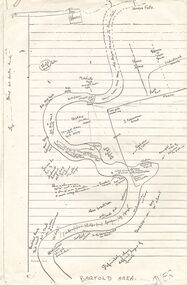
Document - PETER ELLIS COLLECTION: SKETCH OF THE BARFOLD GORGE
... On the sketch is the location of a house, trees, fences, different types of rock, some accessible areas to get down to the river, geological features and water falls....On the sketch is the location of a house, trees, fences, different types of rock, some accessible areas to get down to the river, geological features and water falls. Document PETER ELLIS COLLECTION: SKETCH OF THE BARFOLD GORGE ...Two photocopies of hand-drawn sketch of the Barfold Gorge. On the sketch is the location of a house, trees, fences, different types of rock, some accessible areas to get down to the river, geological features and water falls.place, land, barfold gorge, peter ellis collection, barfold area, mitchell's falls, queen's fall -
 Malmsbury Historical Society
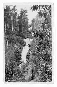
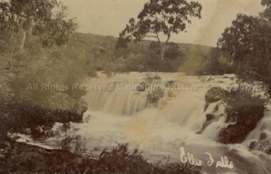
Postcard (Item), Postcard Ellis Falls Malmsbury C1907?, Malmsbury c1907
... Buildings - Ellis Water Falls People - Ellis Family...Malmsbury Historical Society Malmsbury Mechanics Institute 71 Mollison Street Malmsbury daylesford-and-the-macedon-ranges Buildings - Ellis Water Falls People - Ellis Family Postcard Ellis Falls Malmsbury C1907? ...Buildings - Ellis Water Falls People - Ellis Family -
 Stawell Historical Society Inc
Photograph, Silver Band Falls in the Grampians with Mrs Howlld in the front of photo
... Silver Band Falls. Water Fall in the Grampians with group of people posing for photo. ...Stawell Historical Society Inc 46 Longfield St Stawell grampians Silver Band Falls. Water Fall in the Grampians with group of people posing for photo. ...Silver Band Falls. Water Fall in the Grampians with group of people posing for photo. Mrs Howlld front of photo and some of Heals.shire -
 Halls Gap & Grampians Historical Society
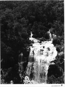
Photograph - B/W, C 1960s
... The river comes into the falls in two separate streams and there is a large volume of water flowing. ...The river comes into the falls in two separate streams and there is a large volume of water flowing. ...A Forestry Commission photo of MacKenzie Falls.Photo shows a large waterfall (MacKenzie Falls), taken from a fairly high vantage point. The river comes into the falls in two separate streams and there is a large volume of water flowing. The falls are surrounded by thick bush."Publicity & Public Relations branch. When reproducing please Acknowledge FORESTS COMMISSION, VICTORIA. Negative No. 322-2" stamped on rear (except negative number, which is hand written in pen)scenery, mackenzie falls -
 Wodonga & District Historical Society Inc
Banner - Lions Club of Wodonga
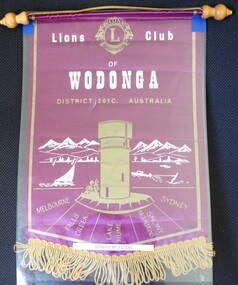
... At the top centre: The logo of Lions International Across the centre of banner: Lions Club of Wodonga / District 201C Australia In semi-circle below Water Tower: Melbourne/ Falls Creek/Lake Hume/ Snowy Mountains/ Sydney...Les Cole Wodonga Lions Club Lions International At the top centre: The logo of Lions International Across the centre of banner: Lions Club of Wodonga / District 201C Australia In semi-circle below Water Tower: Melbourne/ Falls Creek/Lake Hume/ Snowy Mountains/ Sydney A small purple and gold fringed banner with the emblem of Wodonga Lions Club Lions Club of Wodonga Banner Lions Club of Wodonga ...Leslie William Cole was born on 31 January 1920 in Albury, the first child of William James Cole and Gwendoline Fair. Les spent most of his childhood living with his grandparents in Bethanga, Victoria. In 1934 when he finished school, Les moved into Wodonga. His first job was at Mates Timber Yard. He later worked for Mylons of Wodonga driving taxis and buses. In 1939 after completing militia training, Les applied to enlist with the RAAF and eventually trained as an Aircraft Mechanic. He was posted to the 6th Squadron, serving in Port Moresby, Milne Bay and Goodenough Island before returning to the RAAF base in Sale, Victoria. On discharge. Les returned to Wodonga and resumed working with Mylons. After a range of jobs, Les and his wife Lorna operated a shop in Ariel Street, Wodonga. In the community, Les was a founding member of Wodonga Lions Club. He also joined the Civil Defence which was a predecessor off the SES. He became the Communications Officer and trained other members. Les became the first Controller of the Wodonga Branch of the State Emergency Service, a position he held for 17 years. The new SES headquarters was named in his honour. In retirement he also worked as a Volunteer Community Driver. Les was also named Wodonga Citizen of the Year in 1984 Les continued living in Wodonga until the age of 103 in 2023, when he moved to Melbourne to be closer to his children. He passed away on 12 December 2023. The Lions Club of Wodonga was chartered in 1965 with 18 Founding Members including Les Cole. Lions Australia was first formed in Lismore, NSW in September and has grown to be Australia’s largest service club organisation.A small purple and gold fringed banner with the emblem of Wodonga Lions ClubAt the top centre: The logo of Lions International Across the centre of banner: Lions Club of Wodonga / District 201C Australia In semi-circle below Water Tower: Melbourne/ Falls Creek/Lake Hume/ Snowy Mountains/ Sydneyles cole, wodonga lions club, lions international -
 Ballarat Heritage Services
Photograph - Photograph - Colour, Wannon Falls, 2012, 18/08/2012
... Located 20km from Hamilton and around 15 km from Coleraine, the Wannon Falls present a spectacular display of water flowing down the falls into a deep plunge pool below. ...Ballarat Heritage Services PO Box 2209 Bakery Hill Post Office goldfields Located 20km from Hamilton and around 15 km from Coleraine, the Wannon Falls present a spectacular display of water flowing down the falls into a deep plunge pool below. ...Located 20km from Hamilton and around 15 km from Coleraine, the Wannon Falls present a spectacular display of water flowing down the falls into a deep plunge pool below. The falls were created by basalt lava flow that surged up stream to the Wannon River.Colour photographs of Wannon Falls, Victoria.warrnambool, hopkins river, mouth, sea, wannon falls -
 Kew Historical Society Inc
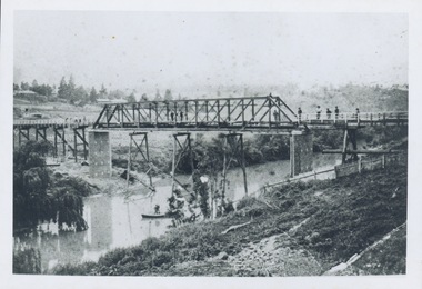
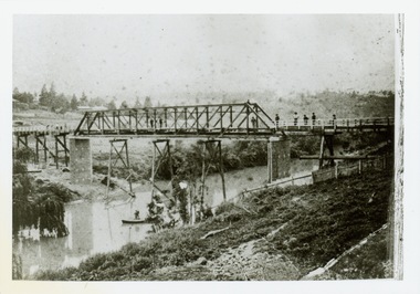
Print - Walmer Street Foot Bridge
... A section of pipe on the near side of the bridge is a remnant of the irrigation pipes that carried water from above Dight's falls to the Melbourne Botanic Gardens. ...A section of pipe on the near side of the bridge is a remnant of the irrigation pipes that carried water from above Dight's falls to the Melbourne Botanic Gardens. ...A bridge to Walmer Street, Kew, from Abbotsford was located at the northern end of Burnley Street. It was a foot bridge.Photographic print of the Walmer Street Bridge. The view of the Bridge is from the Abbotsford side of the Yarra. A section of pipe on the near side of the bridge is a remnant of the irrigation pipes that carried water from above Dight's falls to the Melbourne Botanic Gardens. The former bridge, constructed in 1896 was swept away in the 1901 Flood. It has two major brick piers while the remainder of the trestle supports are metal. The original photograph from which this copy was made was taken after 1901 as it shows the second bridge under construction. Houses in Young Street, Kew, can be seen on the far side of the river.Written on reverse: "Walmer St. Bridge. Erected 1896. Being rebuilt after 1901 flood damaged it. Houses on left are in Young St."bridges -- kew (vic.), walmer street bridge, melbourne botanic gardens -
 Kew Historical Society Inc
Print - Walmer Street Foot Bridge, 1901
... A section of pipe on the near side of the bridge is a remnant of the irrigation pipes that carried water from above Dight's falls to the Melbourne Botanic Gardens. ...A section of pipe on the near side of the bridge is a remnant of the irrigation pipes that carried water from above Dight's falls to the Melbourne Botanic Gardens. ...Photographic print of the Walmer Street Bridge. The view of the Bridge is from the Abbotsford side of the Yarra. A section of pipe on the near side of the bridge is a remnant of the irrigation pipes that carried water from above Dight's falls to the Melbourne Botanic Gardens. The former bridge, constructed in 1896 was swept away in the 1901 Flood. It has two major brick piers while the remainder of the trestle supports are metal. The original photograph from which this copy was made was taken after 1901 as it shows the second bridge under construction. Houses in Young Street, Kew, can be seen on the far side of the river.Reverse: " Walmer St footbridge 1901 being repaired after flood / Constructed 1892 substantially renewed in 1901 and in 1928 / Rebuilt in 1977 by Kew Council aided by State funding. Won for designer Martin Aylard a New Zealand award presented by the timber Research & Development Assoc / Site of Simpsons Road passenger foot ferry". bridges - yarra river -- kew (vic.), walmer street bridge -- kew (vic.) -
 Eltham District Historical Society Inc
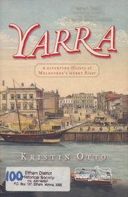
Book, Kristin Otto, Yarra : a diverting history of Melbourne's murky river / Kristin Otto, 2005
... Falls as, he wrote, 'Yarrow Yarrow'. It was only some months later that Wedge discovered they had been referring to the pattern and movement of water over the Falls, not the river itself. ...Falls as, he wrote, 'Yarrow Yarrow'. It was only some months later that Wedge discovered they had been referring to the pattern and movement of water over the Falls, not the river itself. ..."It was John Wedge, Batman's private surveyor, who named the Yarra Yarra. In September 1835 he was at the Turning Basin with some Kulin and heard them identify the river as it came over the Falls as, he wrote, 'Yarrow Yarrow'. It was only some months later that Wedge discovered they had been referring to the pattern and movement of water over the Falls, not the river itself. And ever since, it has been the Yarra's fate to be misunderstood: maligned for its muddiness, ill-used as sewer and tip; scooped, sculpted, straightened and stressed, 'cleaned up' to the detriment of its natural inhabitants; built-over, under and beside; worked mercilessly and then bridged almost to maritime extinction. In Kristin Otto's superbly entertaining new history, the whole sorry tale is laid bare. From the creation stories of Kulin owners and geologist blow-ins (and Robert Hoddle's bad-tempered expedition to the headwaters) to the twenty-first-century waterside building boom, Otto traces the course of Melbourne's murky river. Erudite, affectionate and witty, with more meanders and diversions than the river itself, Yarra is both a fascinating read and a fitting tribute to the 'noble stream'." -- Publisher's website.Paperback; [viii], 245 p. : illus., maps ; 24 cm.ISBN 1920885781yarra river -
 Warrnambool and District Historical Society Inc.
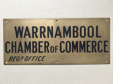
Brass Plate, Warrnambool Chamber of Commerce
... The Chamber over the next thirty years covered many business issues such as trading hours, transport, and public holidays but also put forward ideas which related to water and sewerage matters.ideas were even put forward in 1907 regarding utilising the Hopkins Falls to generate power As an organisation it has waxed and waned in Warrnambool with various names but all working towards improving trade and business opportunities in the town. ...The Chamber over the next thirty years covered many business issues such as trading hours, transport, and public holidays but also put forward ideas which related to water and sewerage matters.ideas were even put forward in 1907 regarding utilising the Hopkins Falls to generate power As an organisation it has waxed and waned in Warrnambool with various names but all working towards improving trade and business opportunities in the town. ...The Chamber of commerce was commenced in Warrnambool in March 1888 to consider firstly what could be done to assist the dairy industry which at the time was facing record low prices for its butter. Co-operatives had been started in Gippsland around that time and it was decided to start co-operative dairy factories at Woodford, Panmure and Framlingham, shortly followed by the Warrnambool Butter and cheese factory at Allansford. The Chamber over the next thirty years covered many business issues such as trading hours, transport, and public holidays but also put forward ideas which related to water and sewerage matters.ideas were even put forward in 1907 regarding utilising the Hopkins Falls to generate power As an organisation it has waxed and waned in Warrnambool with various names but all working towards improving trade and business opportunities in the town. A link to one of Warrnambool's organisations which over the decades has worked to improve the prosperity of the townRectangular brass plate with text stamped and infilled with black.Six screw holes. Fine bevelled edge.Warrnambool Chamber of Commerce. Regd Office.warrnambool, warrnambool chamber of commerce, commerce in warrnambool -
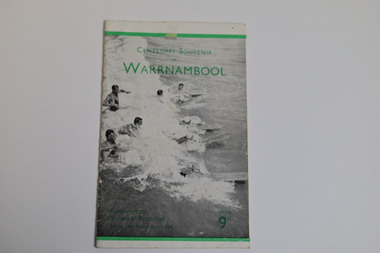 Warrnambool and District Historical Society Inc.
Booklet - Centenary Souvenir of Warrnambool, H. J. Paynter, 1934
... water (five male & four female) some with surfboards. There is a 4mm green line printed 12mm from the upper edge and a 3mm green line printed 6mm from the lower edge of the cover. There is green printing over the photograph on the front cover. On the rear cover there are two small black and white photographs of an aerial view of the city of Warrnambool and the Hopkins Falls...water (five male & four female) some with surfboards. There is a 4mm green line printed 12mm from the upper edge and a 3mm green line printed 6mm from the lower edge of the cover. There is green printing over the photograph on the front cover. On the rear cover there are two small black and white photographs of an aerial view of the city of Warrnambool and the Hopkins Falls ...In 1934, Victoria and Melbourne celebrated their centenaries. Realising how impossible it would be for the majority of Warrnambool residents to participate in the Victorian celebrations, the organising committee of the Warrnambool Centenary celebrations devised a week long comprehensive programme of activities including exhibitions, a pageant re-enactment at the breakwater and a mass children's display at the showgrounds. Sir Harold Gengoult Smith officially opened the Warrnambool Centenary Exhibition of Arts, Crafts, Antiques and Historical Relics. This booklet was designed and written in 1934 for the Warrnambool Centenary festivities by Frank H. Ford, Lava Street, Warrnambool. The souvenir booklet contains a brief history of Warrnambool, a map and description of Warrnambool and its facilities in 1934.The last three pages include a business directory which would be useful for research.A twenty page booklet printed on shiny paper. The front cover has a black and white photo of nine swimmers in the water (five male & four female) some with surfboards. There is a 4mm green line printed 12mm from the upper edge and a 3mm green line printed 6mm from the lower edge of the cover. There is green printing over the photograph on the front cover. On the rear cover there are two small black and white photographs of an aerial view of the city of Warrnambool and the Hopkins Falls in flood. The green line extend across the rear cover and are intersected by a perpendicular 4mm green line running from the upper to the lower edge 18mm to the left of the spine. Words are printed in black on the rear cover and the printer details are printed in green at the bottom edge.Front cover: Centenary Souvenir of Warrnambool Warrnambool Centenary Festivities 13th to 24th November 1934 Price 9d Rear Cover: Beautiful Warrnambool "City of the West" Victoria Australiawarrnambool, frank h. ford, foyle photos, a. wilkins photos, warrnambool centenary festivities 1934, warrnambool souvenir, warrnambool business directory -
 Warrnambool and District Historical Society Inc.
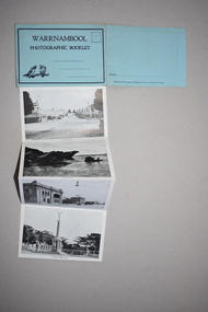
Souvenir - Warrnambool Photographic Booklet, 1940s
... Falls, the mouth of the Hopkins River, Shelly Beach, the Breakwater, the Botanical Gardens etc. Tourism in Warrnambool began to be important towards the end of the 19th century when the coastal scenery, the beaches and the Sea Water Baths were advertised to promote Warrnambool as a spa resort town. ...Falls, the mouth of the Hopkins River, Shelly Beach, the Breakwater, the Botanical Gardens etc. Tourism in Warrnambool began to be important towards the end of the 19th century when the coastal scenery, the beaches and the Sea Water Baths were advertised to promote Warrnambool as a spa resort town. ...This item is a souvenir booklet that would have been purchased by a tourist in the Warrnambool district in the mid 20th century. The photographs are representative of the tourist attractions of the area – Hopkins Falls, the mouth of the Hopkins River, Shelly Beach, the Breakwater, the Botanical Gardens etc. Tourism in Warrnambool began to be important towards the end of the 19th century when the coastal scenery, the beaches and the Sea Water Baths were advertised to promote Warrnambool as a spa resort town. Today tourism is a major industry in the city. This item is of minor interest as a souvenir of the type of postcard purchased by tourists in the mid 20th century. This is a piece of blue paper folded in two with black and blue printing on the front and back covers and an image of two kookaburras on the front cover. In the back of the front cover is pasted a strip of paper containing 13 black and white photographs folded in concertina fashion to form a booklet. The front cover has an extension that fits into a slot on the back cover to enclose the photographs. There is space for a stamp and an address on the front cover and space for the name of the sender on the back cover. There is pencil writing on the space for the stamp.Warrnambool Photographic Booklet 9d. (ninepence) warrnambool souvenir, warrnambool tourist attractions -
 Warrnambool and District Historical Society Inc.
Souvenir - Shipwreck item, Falls of Halladale, 1886
... Falls of Halladale was a four-masted iron-hulled barque built for the long-distance bulk carrier trade. In dense fog on the night of 14 November 1908 she was sailed onto rocks off Peterborough due to a navigational error. The 29 crew abandoned ship safely and reached shore by boat. The ship was left foundering with sails unfurled. For weeks afterwards large crowds gathered to view the ship as she gradually broke up and sank in the shallow water...Falls of Halladale was a four-masted iron-hulled barque built for the long-distance bulk carrier trade. In dense fog on the night of 14 November 1908 she was sailed onto rocks off Peterborough due to a navigational error. The 29 crew abandoned ship safely and reached shore by boat. The ship was left foundering with sails unfurled. For weeks afterwards large crowds gathered to view the ship as she gradually broke up and sank in the shallow water ...The Falls of Halladale was a four-masted iron-hulled barque built for the long-distance bulk carrier trade. In dense fog on the night of 14 November 1908 she was sailed onto rocks off Peterborough due to a navigational error. The 29 crew abandoned ship safely and reached shore by boat. The ship was left foundering with sails unfurled. For weeks afterwards large crowds gathered to view the ship as she gradually broke up and sank in the shallow water. Shortly after the accident the ship's master, Captain Thomson, faced a Court of Marine Enquiry in Melbourne. He was found guilty of a gross act of misconduct, having carelessly navigated the ship, neglected to take proper soundings and failing to place the ship on a port tack before it became too late to avoid shipwreck. Thomson's punishment included a small fine and six months suspension of his Master's Certificate of Competency. The hull lies on its starboard side about 300 metres off-shore in 3-15 metres of water. The original cargo included 56,763 roofing slates and coils of barbed wire. 22,000 slates were salvaged in the 1980s and used as roofing at Flagstaff Hill Maritime Village, Warrnambool.This item has historical significance as it came from one of the known shipwrecks along the South West coast of Victoria. There are a number of photographs of the wreck as it founded on the rock and hence is an image with which many people are familiar. Curved piece of timber with flat base from the wreck of the ship Falls of Halladale. Inside is recessed with slight ledge near back. A chunk of timber is missing on the top. The face has swirled carvings with leaf and seed design and base curved to the edge.Hand painted in red paint on inside bottom edge 'PETERBOROUGH'. Hand painted in white paint on bottom 'FALLS OF HALLADALE/WRECKED/PETERBOROUGH/VIC/NOV. 1908'melbourne, shipwrecks, flagstaff hill maritime village, warrnambool, falls of halladale, barques, peterborough victoria, roofing slates, captain thomson, thomson, court of marine enquiry -
 Kiewa Valley Historical Society
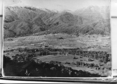
Photograph - Mt Beauty Camp, Estimated 1950-1951
... Falls Creek can clearly be seen. Snow capped Mt. Bogong is in the upper left of the photo with Mt. Beauty behind the township rising to Big Hill beyond that. Shows the newly constructed town of Mt. Beauty surrounded by farmland and before the regulating pondage was built to discharge water ...This photo is of the very newly constructed State Electricity Commission town of Mt. Beauty. The houses up to Nelse street were erected from 1946 onward and then the township was extended beyond Nelse Street in 1950 which places this photograph about 1950/51. There is no evidence of work being commenced on the regulating pondage but the tail race canal can be seen on the centre right of photo. The workmen's camp was enlarged in 1950 to the extent of providing accommodation for a total of 1,200. There are a number of dwellings on Simmonds Creek and the road to Falls Creek can clearly be seen. Snow capped Mt. Bogong is in the upper left of the photo with Mt. Beauty behind the township rising to Big Hill beyond that.Shows the newly constructed town of Mt. Beauty surrounded by farmland and before the regulating pondage was built to discharge water from the power stations via the West Kiewa tail race tunnel into the Kiewa River. Copy of black and white photograph of Mt Beauty CampWritten on the back in black ink - A Campenmt beauty camp, secv, construction town -
 Kiewa Valley Historical Society
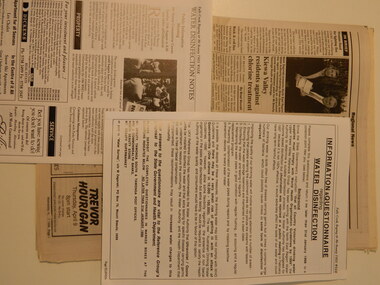
Papers - Mt Beauty Drinking Water 1997, 1997 - 1998
... water in Mt Beauty in 1997-1998. The papers consist of articles in a green folder, the newspaper "The Alpine Times" x2, the Ovens & Kiewa 'Valley Echo' and the local Falls Creek and Bogong, Mt Beauty news 'This Week' x5....water in Mt Beauty in 1997-1998. The papers consist of articles in a green folder, the newspaper "The Alpine Times" x2, the Ovens & Kiewa 'Valley Echo' and the local Falls Creek and Bogong, Mt Beauty news 'This Week' x5. ...In 1996, the Australian Drinking Water Guidelines, instead of World Health Organisation Guidelines introduced in 1983, were introduced. The Australian guidelines allowed for some flexibility and the Upper Kiewa Community Consultative Committee supported a package proposal that included Ultra Violet/Ozone treatment. The debate was a rejection of chlorination by a public meeting in Mt Beauty in Feb. 1997.Mt Beauty residents were asked about the treatment of their drinking water at a public meeting and by an Information Questionnaire. North East Region Water Authority was involved - the debate is an example of community consultation, drinking water standards and the input of the authorities that were involved.Papers re introducing the chlorination of the water in Mt Beauty in 1997-1998. The papers consist of articles in a green folder, the newspaper "The Alpine Times" x2, the Ovens & Kiewa 'Valley Echo' and the local Falls Creek and Bogong, Mt Beauty news 'This Week' x5.drinking water, chlorination, ultra violet/ozone treatment, community consultation -
 Kiewa Valley Historical Society
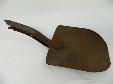
Shovel head - Fainter Falls
... shovel. fainters falls. bogong. walking track. fire track. water....It was left there some time ago by a previous visitor to the Falls indicating that the Falls were accessible and attracted visitors many years ago. shovel. fainters falls. bogong. walking track. fire track. water. Rusty metal shovel head curved on each side and rounded at the front. ...The Fainter Falls Walking Track was originally accessible via a fire fighting access trail, which was used by fire-fighters putting out spot fires caused by lightening strikes. The fires in the summer of 2003, highlighted the beauty of this area and provided the residents with the opportunity to consider the redevelopment of the trail. Work to establish a 700 metre grade 2 walking trail with a 50 metre grade 3 extension trail to the Falls began in 2005. It also includes 3 observation decks, a bridge over a creek crossing, car parking and interpretative signage.The shovel was found during work on the Fainter Falls track. It was left there some time ago by a previous visitor to the Falls indicating that the Falls were accessible and attracted visitors many years ago.Rusty metal shovel head curved on each side and rounded at the front. At the back of the blade it is attached on top with 3 nails to the top piece. The top metal piece overlaps the blade by 6.5 cm longitudinally x 5 cm across. On the back the metal piece overlaps the blade by 12 cm both longitudinally and across the handle end but tapers to a point. It has 6 nails attaching it. Both metal pieces are attached to the blade and curve parallel and around so that a wooden handle would fit between them. This would have 2 nails passing through both metal pieces and the handle. (The handle is missing.) shovel. fainters falls. bogong. walking track. fire track. water. -
 Kiewa Valley Historical Society
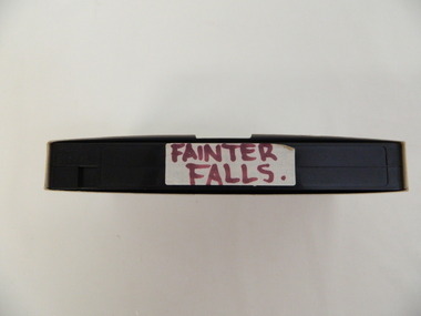
Video - Fainter Falls, Fainter Falls, 2003 - 2008
... This video recording is a visual recording of the process of the establishment of the Fainter Falls Walking Trail giving an insight into the process, the work, tools and materials used for such work from 2003 to 2008. It also shows the vegetation in the area and the amount of water flowing at the time. fainter falls. bogong. walking trail. fire track. national parks of victoria "Fainter Falls" White cardboard cover with black plastic video labelled "Fainter Falls" on outer edge. ...Visual workings and development of the Fainter Falls Trail completed in 2008. The trail was originally accessible via a fire fighting access trail. The fire in the summer of 2003 highlighted the beauty of the area and provided the residents of the Kiewa Valley with the opportunity to consider the redevelopment of the trail. Work to establish a 700 metre grade 2 walking trail with a 50 metre grade 3 extension trail to the Falls began in 2005. It also includes 3 observation decks, a bridge over a creek crossing, car parking and interpretive signage.This video recording is a visual recording of the process of the establishment of the Fainter Falls Walking Trail giving an insight into the process, the work, tools and materials used for such work from 2003 to 2008. It also shows the vegetation in the area and the amount of water flowing at the time.White cardboard cover with black plastic video labelled "Fainter Falls" on outer edge."Fainter Falls"fainter falls. bogong. walking trail. fire track. national parks of victoria -
 Kiewa Valley Historical Society
Photographs - Mt Beauty, Tawonga South and Falls Creek
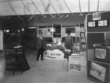
... Falls Creek 15. Two girls 16. Mt Beauty - Home Improvement Centre 17. Tawonga District Hospital/Mt Beauty Hospital before the Nursing Home - removing pine trees 18. Water...Falls Creek 15. Two girls 16. Mt Beauty - Home Improvement Centre 17. Tawonga District Hospital/Mt Beauty Hospital before the Nursing Home - removing pine trees 18. Water ...Mt Beauty and Tawonga South are in the Kiewa Valley Mt Beauty and Tawonga are in the Kiewa Valley. Many of these photos record people who lived in these towns and their activities.Collection of black and white photos of Mt Beauty and Tawonga. Most are labelled (and some include names but no dates) in pencil on the back.Varying sizes. 1. Marketing Falls Creek 2. Driver Education Car Presentation- Mt Beauty Secondary College 3. Start of Mt Beauty Marathon 4. Mount Beauty Paramedical Day Care Centre 5. Falls Creek - Original Halley's Comet 6. Falls Creek - Original Snow-making on Twin Towers 7. Group of 10 girls 8. Mt Beauty Primary School - Tidy Towns Competition 9.Mt Beauty Primary School 10. Start of Mt Beauty Marathon 11. Lou Leiberman - Local Member 12. Bank Manager, Commonwealth Bank on left. 13. Driver Education Car - Mt Beauty Secondary College 14. Original Snow-making on Twin Towers at Falls Creek 15. Two girls 16. Mt Beauty - Home Improvement Centre 17. Tawonga District Hospital/Mt Beauty Hospital before the Nursing Home - removing pine trees 18. Water Board Installation at Tawonga South (outside Rookes house) 19. Dederang Catholic Church 20. Two men (names on back) 21. Tawonga Store 22. Mt Beauty - old butcher shop on right hand side 23.Tidy Towns Mt Beauty Labelled in pencil on the backmt beauty, tidy towns, driver education, marathon, falls creek -
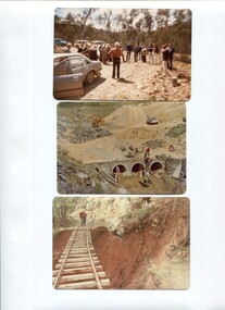 Kiewa Valley Historical Society
Photos - x 29 Falls Creek and Bogong High Plains
... Water Board, SECV and other. These men represented the local organisations of the day. Historic changes include the diversity of people who represent organisations today and the actual type of organisations that exist. S.E.C.V. 1980s Bright Shire 1980s Coloured Falls ...Photos taken by Alec McCullock circa 1980s. Some of the people include Brian Goss, Bright Shire or Water Board; Graham Cooper, Bright Shire and Paul Goldstone, Bright Shire Surveyor. Appears to be an inspection party comprising Shire, UK Water Board, SECV and other.These men represented the local organisations of the day. Historic changes include the diversity of people who represent organisations today and the actual type of organisations that exist.Coloured Falls Creek & Bogong High Plains c 1980s. Includes SECV People and work s.e.c.v. 1980s, bright shire 1980s