Showing 207 items matching "water source"
-
 The Beechworth Burke Museum
Photograph - Lantern Slide, c1900
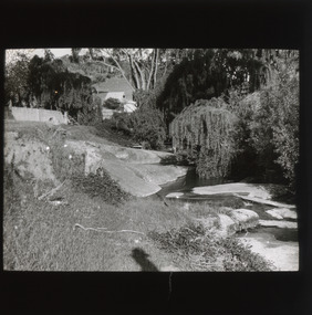
... ...water source...Although the exact location of the photograph is yet to be determined, the water source pictured may feed into the bigger system that flows through Beechworth Gorge. ...Although the exact location of the photograph is yet to be determined, the water source pictured may feed into the bigger system that flows through Beechworth Gorge. ...This image shows a view of a properties bordering a river in the vicinity of Beechworth in approximately 1900. Although the exact location of the photograph is yet to be determined, the water source pictured may feed into the bigger system that flows through Beechworth Gorge. A man wearing a hat, possibly the photographer, is silhouetted in the foreground of the picture. Lantern slides, sometimes called 'magic lantern' slides, are glass plates on which an image has been secured for the purpose of projection. Glass slides were etched or hand-painted for this purpose from the Eighteenth Century but the process became more popular and accessible to the public with the development of photographic-emulsion slides used with a 'Magic Lantern' device in the mid-Nineteenth Century. Photographic lantern slides comprise a double-negative emulsion layer (forming a positive image) between thin glass plates that are bound together. A number of processes existed to form and bind the emulsion layer to the base plate, including the albumen, wet plate collodion, gelatine dry plate and woodburytype techniques. Lantern slides and magic lantern technologies are seen as foundational precursors to the development of modern photography and film-making techniques.This glass slide is significant because it provides insight into Beechworth's built environment and natural landscape in the early Twentieth Century, around the time of Australia's Federation. It is also an example of an early photographic and film-making technology in use in regional Victoria in the time period.Thin translucent sheet of glass with a square image printed on the front and framed in a black backing. It is held together by metals strips to secure the edges of the slide.burke museum, beechworth, lantern slide, slide, glass slide, plate, burke museum collection, photograph, monochrome, photographer, beechworth gorge, river, stream, water source, 1900s -
 Clunes Museum
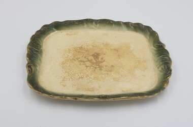
Functional object - GOLD MINING PAN
... METAL DISH FOR WASHING GOLD FROM WATER SOURCE...Clunes Museum 36 Fraser Street enter building through Collins Place Clunes goldfields GOLD PANNING FOSSICKING GOLD WASHING METAL DISH FOR WASHING GOLD FROM WATER SOURCE Functional object GOLD MINING PAN ...METAL DISH FOR WASHING GOLD FROM WATER SOURCEgold panning, fossicking, gold washing -
 Cheese World Museum
Cooler, Dairy cream cooler
... There are two outlets at the side, one to attach the to the water source, the other to an outlet....There are two outlets at the side, one to attach the to the water source, the other to an outlet. Dairy cream cooler Cooler ...The Percy Uebergang family lived at Tooram Park, Allansford from 1912 until 1992. Percy and Myrtle Uebergang's children were twins, Ray and Joyce born in 1926 who lived at Tooram Park until their deaths, Ray in 1986 and Joyce in 1992. Neither Ray nor Joyce married and following the death of her brother Joyce set up the Ray and Joyce Uebergang Foundation which supports the local community. This cream cooler is part of the collection of items given into the care of the Cheese World Museum. See reference in Chandler catalogue p.167 Uebergang catalogue No.N17 A steel cream cooler with a trough mounted on top of a rippled rectangular section. The trough has 10 small holes in the base, which allows the cream to filter over the rippled faces. Water ran through the centre of the washboard to cool the cream. There are two outlets at the side, one to attach the to the water source, the other to an outlet.Joyce [in raised lettering on both sides at the top. Uebergang No. N17]allansford, uebergang, joyce dairy utensils, cream coolers, coolers, dairying -
 Buninyong & District Historical Society
Photograph - B/W photograph, Mrs. Bon Strange (nee Lorensini), Old Brewery and Gong Reservoir Buninyong, c 1935, c1935
... Early gold-rush building, originally Brewery, next to Gong Reservoir (early water source for township). Building since converted to residence....Buninyong & District Historical Society Old Court House, Buninyong Town Hall 313 Learmonth Street Buninyong goldfields Early gold-rush building, originally Brewery, next to Gong Reservoir (early water source for township). Building since converted to residence. ...Early gold-rush building, originally Brewery, next to Gong Reservoir (early water source for township). Building since converted to residence.Record of early building as of mid 1930'sLaser copy of hand-tinted photograph of Old Brewery and Gong Reservoir Buninyong, c 1935, fields rising behind, tall treees, partially obscured house.building, buninyong, brewery, industry, landscape -
 Nhill and District Historical Society Inc.
Book - Beersheba, The men of the 4th light Horse Regiment who charged on the 31st October 1917, 2018
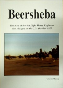
... The brigade's charge was a strategic move to break the Turkish line and secure vital water sources for their horses, which had been crucial for their operations in the desert. ...The brigade's charge was a strategic move to break the Turkish line and secure vital water sources for their horses, which had been crucial for their operations in the desert. ...The 4th Light Horse Regiment biography of soldiers who were at the charge of the Battle of Beersheba.white soft cover with title and image of the Light Horse chargenon-fictionThe 4th Light Horse Regiment biography of soldiers who were at the charge of the Battle of Beersheba. biography, war history, 4th light horse regiment, australian light horse, world wa 1, regimental history, campaigns -middle east, campaigns-palestine -
 Emerald Museum & Nobelius Heritage Park
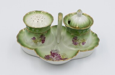
Ceramic - Ceramic cruet set consisting of stand, pepper container & salt container
... They called their property 'Silver Wells' because of finding a pure and plentiful water source when digging their initial well. Silver Wells became the commercial centre of the early Gembrook settlement with shops, post office etc. ...They called their property 'Silver Wells' because of finding a pure and plentiful water source when digging their initial well. Silver Wells became the commercial centre of the early Gembrook settlement with shops, post office etc. ...This cruet set was owned by the Ure family. Scottish migrants, John and Jane Ure settled on acreage north of Gembrook in 1874. They called their property 'Silver Wells' because of finding a pure and plentiful water source when digging their initial well. Silver Wells became the commercial centre of the early Gembrook settlement with shops, post office etc. When the train came through in 1900 the Gembrook commercial centre shifted to its present location, near the railway station. The Ure family continued to play a significant role in the Gembrook community. Items were donated by Jean WorrellThe Ure family of 'Silver Wells' was significant in the early history of Gembrook.Ceramic cruet set consisting of a stand with a handle and containing a pepper container and salt container which are removable. Red floral decoration with some green on a white background. Gold rim.1889, silver wells -
 Emerald Museum & Nobelius Heritage Park
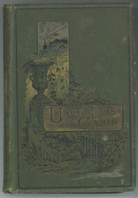
Book - Fiction Book, Harriet Beecher Stowe, Uncle Tom's Cabin, 1889
... They called their property 'Silver Wells' because of finding a pure and plentiful water source when digging their initial well. Silver Wells became the commercial centre of the early Gembrook settlement with shops, post office etc. ...They called their property 'Silver Wells' because of finding a pure and plentiful water source when digging their initial well. Silver Wells became the commercial centre of the early Gembrook settlement with shops, post office etc. ...This book, Uncle Tom's Cabin was the best selling novel in the 19th century in the USA. It was given to Alexander Ure in 1889, the son of Scottish migrants, John and Jane Ure who settled on acreage north of Gembrook in 1874. They called their property 'Silver Wells' because of finding a pure and plentiful water source when digging their initial well. Silver Wells became the commercial centre of the early Gembrook settlement with shops, post office etc. When the train came through in 1900 the Gembrook commercial centre shifted to its present location, near the railway station. The Ure family continued to play a significant role in the Gembrook community.The Ure family of 'Silver Wells' was significant in the early history of Gembrook.Moss green hard cover book with title embossed on gold panel. 326 pages.On front cover printed: 'UNCLE TOM'S CABIN' On page i handwritten: 'Alexander Ure / A Present / from Mr & Mrs Wood / Cot 3rd 1889'alexander ure, uncle tom's cabin, 1889, silver wells -
 Emerald Museum & Nobelius Heritage Park
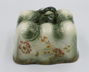
Ceramic - Ceramic cheese cover
... They called their property 'Silver Wells' because of finding a pure and plentiful water source when digging their initial well. Silver Wells became the commercial centre of the early Gembrook settlement with shops, post office etc. ...They called their property 'Silver Wells' because of finding a pure and plentiful water source when digging their initial well. Silver Wells became the commercial centre of the early Gembrook settlement with shops, post office etc. ...This cheese plate and cover which is probably Edwardian was owned by the Ure family. Scottish migrants, John and Jane Ure settled on acreage north of Gembrook in 1874. They called their property 'Silver Wells' because of finding a pure and plentiful water source when digging their initial well. Silver Wells became the commercial centre of the early Gembrook settlement with shops, post office etc. When the train came through in 1900 the Gembrook commercial centre shifted to its present location, near the railway station. The Ure family continued to play a significant role in the Gembrook community. Items were donated by Jean WorrellThe Ure family of 'Silver Wells' was significant in the early history of Gembrook. This ornate cheese cover is indicative of their prosperity.Ornate rectangular ceramic cheese cover with handle on top and floral design on all four sides.silver wells, ure, 1900s -
 Emerald Museum & Nobelius Heritage Park
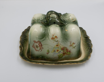
Ceramic - Cheese Plate & Cover
... They settled on acreage north of Gembrook in 1874 which they called 'Silver Wells' because of finding a pure and plentiful water source when digging their initial well. Silver Wells became the commercial centre of the early Gembrook settlement with shops, post office etc. ...They settled on acreage north of Gembrook in 1874 which they called 'Silver Wells' because of finding a pure and plentiful water source when digging their initial well. Silver Wells became the commercial centre of the early Gembrook settlement with shops, post office etc. ...This ornate ceramic cheese plate and cover which is probably early 20th century was owned by the Ure family. Scottish migrants, John and Jane Ure. They settled on acreage north of Gembrook in 1874 which they called 'Silver Wells' because of finding a pure and plentiful water source when digging their initial well. Silver Wells became the commercial centre of the early Gembrook settlement with shops, post office etc. When the train came through in 1900 the Gembrook commercial centre shifted to its present location, near the railway station. The Ure family continued to play a significant role in the Gembrook community. Items were donated by Jean WorrellThe Ure family of 'Silver Wells' was significant in the early history of Gembrook. This ornate ceramic piece is indicative of their prosperity.Ceramic cheese cover and plate. Ornate design in green and white with floral design around all sides. Gold edging. Handle.silver wells, 1900s, ure -
 Emerald Museum & Nobelius Heritage Park
Ceramic - Plate
... They called their property 'Silver Wells' because of finding a pure and plentiful water source when digging their initial well. Silver Wells became the commercial centre of the early Gembrook settlement with shops, post office etc. ...They called their property 'Silver Wells' because of finding a pure and plentiful water source when digging their initial well. Silver Wells became the commercial centre of the early Gembrook settlement with shops, post office etc. ...This plate which is part of an ornate cheese cover and plate appears to be Edwardian. It was owned by the Ure family. Scottish migrants, John and Jane Ure, who settled on acreage north of Gembrook in 1874. They called their property 'Silver Wells' because of finding a pure and plentiful water source when digging their initial well. Silver Wells became the commercial centre of the early Gembrook settlement with shops, post office etc. When the train came through in 1900 the Gembrook commercial centre shifted to its present location, near the railway station. The Ure family continued to play a significant role in the Gembrook community. Items were donated by Jean WorrellThe Ure family of 'Silver Wells' was significant in the early history of Gembrook and this ornate ceramic piece is indicative of their prosperity.Green & White coloured ceramic plate which is part of a matching set comprising a cheese cover and plate.silver wells, ure, 1900s -
Linton and District Historical Society Inc
Mining company registration form, Water Right for Lyndock Company
... Information includes registration number (169), date of registration (16th January 1862), location of the claim, nature of the water right, source of the water supply, site of dams, names of shareholders and their mining right numbers....Information includes registration number (169), date of registration (16th January 1862), location of the claim, nature of the water right, source of the water supply, site of dams, names of shareholders and their mining right numbers. ...The page lists information about water rights granted to the Lyndock Company, a gold mining company which was operating at Coffee Hill near Linton. Information includes registration number (169), date of registration (16th January 1862), location of the claim, nature of the water right, source of the water supply, site of dams, names of shareholders and their mining right numbers.A3 size photocopy of a page which has probably come from a register of mining companies, most likely maintained at the Smythesdale Court of Mines or another local Court of Mines. (The actual source of the document is not known.) The page is numbered "19" at the top left.gold mining, mining companies, court of mines, registration forms, shareholders, water rights, coffee hill (linton), snake valley, smith's gully, james hill, samuel knight, george lowe, edward wenders (winders?), ambrose grose, henry pascoe, daniel mcintyre, john mayne, documents and records, mining company registers -
 City of Moorabbin Historical Society (Operating the Box Cottage Museum)
Document, Photocopy Letter Stephen Charman to Michael Charman UK 1857, 1857
... 'The Spring' was an important water source for the local Aboriginal people and then for the early settlers. ...'The Spring' was an important water source for the local Aboriginal people and then for the early settlers. ...Stephen Charman, aged 21years, arrived in Melbourne in 1842 as one of Henry Dendy's Emigrants. 1852 he purchased 160 acres for £328 bounded by Charman Rd and Balcome Rd. 'The Spring' was an important water source for the local Aboriginal people and then for the early settlers. Charman's first wife Harriet and their infant child died and in 1850 he married a widow with 5 children, Mary Gettens. Their first home was made of wattle and daub and they had 7 more children. Later a weatherboard cottage was built c 1855 Together they developed a market garden and specialized in marigolds which were sold for medicinal purposes to the Melbourne Chemists - Martin & Pleasance . The first Methodist Church Services were held at Spring Grove and the Charmans donated land in 1857 for the first Chapel, Cemetery and Primary School . Mary died 1870 and Stephen married again and moved to Gippsland where he died aged 85 in 1906 Stephen and Mary Charman were pioneer market gardeners in Moorabbin Shire 1842 and were involved in the development of Church, school and community in the area now called Cheltenham. Charman Road Cheltenham was a boundary of their land. Letter, handwritten from Stephen Charman to his brother Michael in UK 1857 x 3 pageshandwrittenmoorabbin, cheltenham, dendy henry, dendy's special survey 1841, assisted emigrants, early settlers, pioneers, market gardeners, marigold flowers, pharmacy, charman stephen, gettens mary, charman harriet, methodist church, primitive methodists, box william, box elizabeth, state schools, education, moorabbin shire, moorabbin roads board, city of moorabbin, kingston city council, charman michael, cancel -
 City of Moorabbin Historical Society (Operating the Box Cottage Museum)
Document, Photocopy Letter Thomas Charman to Michael Charman UK 1878, 1878
... 'The Spring' was an important water source for the local Aboriginal people and then for the early settlers. ...'The Spring' was an important water source for the local Aboriginal people and then for the early settlers. ...Thomas Charman came to Australia with his brother Stephen and went to Sydney. Thomas came to Melbourne c 1853 with a large dray and bullock team and with his son took supplies to the Victorian Gold digging sites. Quite profitably. Stephen Charman, aged 21years, arrived in Melbourne in 1842 as one of Henry Dendy's Emigrants. 1852 he purchased 160 acres for £328 bounded by Charman Rd and Balcome Rd. 'The Spring' was an important water source for the local Aboriginal people and then for the early settlers. Charman's first wife Harriet and their infant child died and in 1850 he married a widow with 5 children, Mary Gettens. Their first home was made of wattle and daub and they had 7 more children. Later a weatherboard cottage was built c 1855 Together they developed a market garden and specialized in marigolds which were sold for medicinal purposes to the Melbourne Chemists - Martin & Pleasance Thomas Charman arrived in Australia 1842 with his brother Stephen and moved to Sydney where he obtained a large dray and bullock team. He delivered supplies to the Goldfields and realized this was more secure than chancing to find gold by digging. Thomas returned to Melbourne when the Victorian Mines became more numerous than NSW and profitably delivered to the Victorian gold fields .Letter, handwritten from Thomas Charman to his brother Michael in UK 1878 x 3 pagesHandwritten -
 Kiewa Valley Historical Society
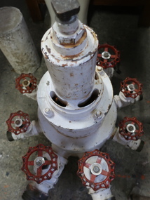
Manifold - Mt Beauty Fire Brigade
... During the firefight water was sourced from a street hydrant via a standpipe, fog nozzles were utilised on all hoses, and subsequently water flow from all nozzles started to reduce to low volumes due to becoming blocked from gravel within the water main.. ...During the firefight water was sourced from a street hydrant via a standpipe, fog nozzles were utilised on all hoses, and subsequently water flow from all nozzles started to reduce to low volumes due to becoming blocked from gravel within the water main.. ...Back in the 1980s there was a house fire in Tawonga South. During the firefight water was sourced from a street hydrant via a standpipe, fog nozzles were utilised on all hoses, and subsequently water flow from all nozzles started to reduce to low volumes due to becoming blocked from gravel within the water main.. The whole water supply was turned off at the standpipe.This manifold was invented enabling only one delivery instead of all deliveries. SEC employees, living in Mt Beauty, designed and built the valve. It minimised the impact damage to water mains created by rapid shutoff of nozzles.Steel white water pipe with 8 outlets each with a red handle for turning water on or off and each with an outlet that can be screwed onto a pipe / hose. The base is white with the top narrow and the bottom wide. Embossed 125 / 200 ....,2 (symbol 'and a half')manifold, mt beauty fire brigade, firefighting equipment -
 City of Moorabbin Historical Society (Operating the Box Cottage Museum)
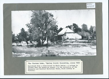
Photograph, B/W Watercolour,'Spring Grove' Charman Cottage built c1855 E Barlow c 1900, Elsie Barlow, c1900
... 'The Spring' was an important water source for the local Aboriginal people and then for the early settlers. ...'The Spring' was an important water source for the local Aboriginal people and then for the early settlers. ...This is a B/W photograph of a Water colour by Elsie Barlow c 1900. The original water-colour is in the collection of the Beaumaris and District Historical Trust in the State Library of Victoria. 'Spring Grove' was the home of the Charman family in the Parish of Moorabbin. Stephen Charman, aged 21years, arrived in Melbourne in 1842 as one of Henry Dendy's Emigrants. 1852 he purchased 160 acres for £328 bounded by Charman Rd and Balcome Rd. 'The Spring' was an important water source for the local Aboriginal people and then for the early settlers. Charman's first wife Harriet and their infant child died and in 1850 he married a widow with 5 children, Mary Gettens. Their first home was made of wattle and daub and they had 7 more children. Later a weatherboard cottage was built c 1855 Together they developed a market garden and specialized in marigolds which were sold for medicinal purposes to the Melbourne Chemists - Martin & Pleasance . The first Methodist Church Services were held at Spring Grove and the Charmans donated land in 1857 for the first Chapel, Cemetery and Primary School . Mary died 1870 and Stephen married again and moved to Gippsland where he died aged 85 in 1906Stephen and Mary Charman were pioneer market gardeners in Moorabbin Shire 1842 and were involved in the development of Church, school and community in the area now called Cheltenham. Charman Road Cheltenham was a boundary of their land. Black & White photograph of a Watercolour of Charman family cottage built 1885 Cheltenham Signed E Barlow on back ; A Cottage in Charman Road - the Dandelion Season / by Elsie Barlow / In the Collection of the State Library Victoria / Reproduction requires the permission of the Library Moorabbin Standard Newspaper moorabbin, cheltenham, dendy henry, dendy's special survey 1841, assisted emigrants early settlers, pioneers, market gardeners, marigold flowers, pharmacy, charman stephen, gettens mary, charman harriet, methodist church, primitive methodists, box william, box elizabeth, state schools, education, moorabbin shire, moorabbin roads board, city of moorabbin, kingston city council -
 City of Moorabbin Historical Society (Operating the Box Cottage Museum)
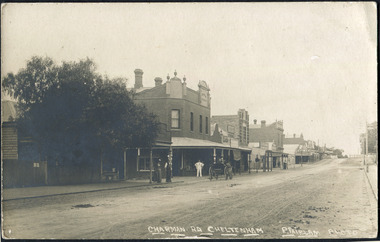
Photographs , Postcards x4 Charman Rd Cheltenham c 1910, c1910
... 'The Spring' was an important water source for the local Aboriginal people and then for the early settlers. ...'The Spring' was an important water source for the local Aboriginal people and then for the early settlers. ...After the arrival of the Cheltenham Railyway Station Charman Road became the main shopping centre. From 1 small shop - Mrs Meeres who sold sweets, school requisites and drapery - it proceeded to develop throughout the 1890's with various traders until the 1910 Postcards show many shops on both sides of the road, Stephen Charman, aged 21years, arrived in Melbourne in 1842 as one of Henry Dendy's Emigrants. 1852 he purchased 160 acres for £328 bounded by Charman Rd and Balcome Rd. 'The Spring' was an important water source for the local Aboriginal people and then for the early settlers. Charman's first wife Harriet and their infant child died and in 1850 he married a widow with 5 children, Mary Gettens. Their first home was made of wattle and daub and they had 7 more children. Later a weatherboard cottage was built c 1855 Together they developed a market garden and specialized in marigolds which were sold for medicinal purposes to the Melbourne Chemists - Martin & Pleasance . The first Methodist Church Services were held at Spring Grove and the Charmans donated land in 1857 for the first Chapel, Cemetery and Primary School . Mary died 1870 and Stephen married again and moved to Gippsland where he died aged 85 in 1906 Stephen and Mary Charman were pioneer market gardeners in Moorabbin Shire 1842 and were involved in the development of Church, school and community in the area now called Cheltenham. Charman Road Cheltenham was a boundary of their land.4x Black & White Postcards c 1910 of Charman Road Cheltenham VictoriaFront; CHARMAN RD. CHELTENHAM P. FAIRLAM PHOTOfairlam p, cheltenham railway station, moorabbin, cheltenham, dendy henry, dendy's special survey 1841, assisted emigrants early settlers, pioneers, market gardeners, marigold flowers, pharmacy, charman stephen, gettens mary, charman harriet, methodist church, primitive methodists, box william, box elizabeth, state schools, education, moorabbin shire, moorabbin roads board, city of moorabbin, kingston city council, cancel, cheltenham primary school -
Linton and District Historical Society Inc
Mining company registration form, Water Right for Devils Kitchen Gold Mining Company
... The page lists information about water rights granted to the Devil's Kitchen GMC, which was operating at Springdallah - registration number (329), date of registration (2nd March 1863), location of the claim, nature of the water right, source of the water supply, site of dams and number of sluice heads, names of shareholders and their mining right numbers, and transfers of share ownership. ...Linton and District Historical Society Inc 69 Sussex Street Linton 3360 goldfields The page lists information about water rights granted to the Devil's Kitchen GMC, which was operating at Springdallah - registration number (329), date of registration (2nd March 1863), location of the claim, nature of the water right, source of the water supply, site of dams and number of sluice heads, names of shareholders and their mining right numbers, and transfers of share ownership. ...The page lists information about water rights granted to the Devil's Kitchen GMC, which was operating at Springdallah - registration number (329), date of registration (2nd March 1863), location of the claim, nature of the water right, source of the water supply, site of dams and number of sluice heads, names of shareholders and their mining right numbers, and transfers of share ownership. This page also includes the registration of a mine operated by Curson and Partner at Dreamer's Hill (registration number 329/2). Very few details about this mine are recorded on the form, other than the names of the two business partners and location of the mine.A3 size photocopy of a page which has probably come from a register of mining companies, most likely maintained at the Smythesdale Court of Mines or another local Court of Mines. (The actual source of the document is not known.) The page is numbered "269" at the top left.gold mining, mining companies, court of mines, registration forms, shareholders, water rights, springdallah, dreamer's hill, devil's kitchen gold mining company, roger evans, henry orr, jas k. davies, arthur j. curson, john burke, documents and records, mining company registers -
 Surrey Hills Historical Society Collection
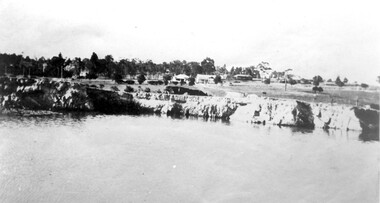
Photograph, Grovedale Road Quarry in the 1920s - looking north, c1920
... Maling grazed cows and used the quarry as a water source. He was the uncle of John Butler Maling, Mayor of Camberwell. ...Maling grazed cows and used the quarry as a water source. He was the uncle of John Butler Maling, Mayor of Camberwell. ...The quarry was part of John Butler Maling's property. He was one of the original settlers of the area and farmed the area between Weybridge Street and Whitehorse Road. Clay was quarried from part of this area and used to make the bricks used in the construction of his home, known as 'Ancyra'. This is still extant at the corner of Weybridge and James Streets. Maling grazed cows and used the quarry as a water source. He was the uncle of John Butler Maling, Mayor of Camberwell. He was married to Kate Conlon in 1882. They had 3 children: Silas Young, Alick and Zillah. Maling was born in c1829 in Shepreth, Cambridgeshire; he died in Surrey Hills on 9 October 1912 and is buried in Box Hill Cemetery - CE-*-0586. Mrs Kate Maling (born c1859 in Co Meath, Ireland) died at the property on 8 March 1921. She is buried in Brighton General Cemetery. Probate was valued at over 10,000 pounds and included other properties in Sandringham, Hawthorn and Macedon. At the time of her death the Surrey Hills property was described as being 23 cres with 2 brick houses, 1 cow, 2 heifers and 40 fowls or chickens. The property was subdivided after her death. The quarry was filled in after several drownings or near drownings and the land is now occupied by a park and playground maintained by the City of Boroondara. Beckett Park is sited on horizon to the left beyond the trees. This documents the landscape prior to close settlement and is material to early building and farming in the Surrey Hills area.Black and white photo of the quarry between Grovedale Road and James Street taken in the 1920s and looking north. In the foreground is an area of water with high banks dividing the horizontal centre. Beyond are paddocks and trees behind which is a row of at least 3 single-storey houses. Light poles can be seen along a distant street. There are many mature trees in the background. The houses and trees are positioned along Whitehorse Road in the vicinity of Westminster Street. Shadows indicate the photo was taken in early morning or evening.quarries, grovedale road, james street, surrey hills, balwyn, clay quarries, ancyra, kate conlon, kate maling, john butler maling, farming -
 Surrey Hills Historical Society Collection
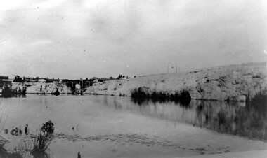
Photograph, Grovedale Road Quarry in the 1920s - looking south, c1920
... Maling grazed cows and used the quarry as a water source. He was the uncle of John Butler Maling, Mayor of Camberwell. ...Maling grazed cows and used the quarry as a water source. He was the uncle of John Butler Maling, Mayor of Camberwell. ...The quarry was part of John Butler Maling's property. He was one of the original settlers of the area and farmed the area between Weybridge Street and Whitehorse Road. Clay was quarried from part of this area and used to make the bricks used in the construction of his home, known as 'Ancyra'. This is still extant at the corner of Weybridge and James Streets. Maling grazed cows and used the quarry as a water source. He was the uncle of John Butler Maling, Mayor of Camberwell. He was married to Kate Conlon in 1882. They had 3 children: Silas Young, Alick and Zillah. Maling was born in c1829 in Shepreth, Cambridgeshire; he died in Surrey Hills on 9 October 1912 and is buried in Box Hill Cemetery - CE-*-0586. Mrs Kate Maling (born c1859 in Co Meath, Ireland) died at the property on 8 March 1921. She is buried in Brighton General Cemetery. Probate was valued at over 10,000 pounds and included other properties in Sandringham, Hawthorn and Macedon. At the time of her death the Surrey Hills property was described as being 23 acres with 2 brick houses, 1 cow, 2 heifers and 40 fowls or chickens. The property was subdivided after her death. The property was subdivided into 110 house blocks in c1923 - see Maling's Estate subdivision flyer on the State Library of Victoria's website. This shows that the Grovedale Park site had been acquired by Camberwell Council by this time. An attached newspaper clipping documents prices realised for a cross-section of blocks. The MMBW map of 1925, also on the SLV website, shows the outline of the clayhole / quarry. The quarry was filled in after several drownings or near drownings and the land is now occupied by a park and playground, known as Grovedale Road Park, maintained by the City of Boroondara. Beckett Park is sited on horizon to the left beyond the trees. This documents the landscape prior to close settlement and is material to early building and farming in the Surrey Hills area.Black and white photo of the quarry between Grovedale Road and James Street taken in the 1920s and looking south. In the foreground is an area of water with reeds in the LH corner. Beyond on the high banks there are single storey houses in the background and (?) some light poles. An object that looks like a tank on posts is in a cutting on the far bank.quarries, grovedale road, james street, clay quarries, farming, kate conlon, kate maling, john butler maling, ancyra -
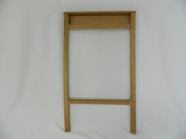 Kiewa Valley Historical Society
Wash Board Glass, mid 1900s
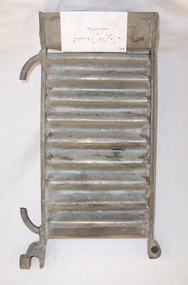
... This lingering usage was due to the fact that rural properties, on the whole, had water supplies sourced from farm dams and be the ones whose priority feed was targeting crops and farm animals before clothes and other domestic requirements. ...This lingering usage was due to the fact that rural properties, on the whole, had water supplies sourced from farm dams and be the ones whose priority feed was targeting crops and farm animals before clothes and other domestic requirements. ...This washboard is relatively "young" in that the timber has not "aged," however it could have been used by a rural family to wash "delicate" clothing which could not be placed within a large family washing machine or "copper". This type of washboard i.e. glass washboard, was used extensively during the war periods, 1914 to 1918 and 1939 to 1945 when corrugated metal was in scarce supply. Rural areas were the last sectors in Australia where washboards where, through necessity( droughts and lack of domestic water), used up until the late 1900s. This lingering usage was due to the fact that rural properties, on the whole, had water supplies sourced from farm dams and be the ones whose priority feed was targeting crops and farm animals before clothes and other domestic requirements. In the two millennium however, most rural areas are well stocked with water supplies and the very strict edict of conserving water, especially during droughts, of earlier times is not so critical.The Kiewa Valley although well supplied by rivers, streams and artesian water does occasionally through severe drought lack of water for farm domestic washing requirements.This washboard is made of a wooden frame and glass insert (corrugated on one side and smooth on the other). The washboard glass panel is contained within the wooden frame by routered grooves. The frame extends beyond the glass to form two legs below the glass insert and a hand grip above it. This hand grip allows for one hand to hold the washboard firmly upright and one hand to rub clothes vigorously (up and down) against the glass ridges.This action combined with a soap and water based freeing agent loosen any dirt particles which can be rinsed off. The appearance of this washboard is basic but does not detract from its effectiveness. The lack of "wear and tear" on the wooden frame suggest limited use. The construction suggests good workmanship even though there is no manufacturer's logo to be found on it.hand washing, household washing, domestic clothes washing, laundry -
 Sunshine and District Historical Society Incorporated
Pamphlet - Know your neighbourhood, Brimbank City Council Dept of Planning and Development, 2011
... Brochure Know your neighbourhood The Sunshine District|Brochure Know your neighbourhood The Deer Park District|Brochure Know your neighbourhood The St Albans District|Brochure Know your neighbourhood The Keilor District|Brochure Know your neighbourhood The Sydenham District|Data Source Profile & Forcast ID using ABS Census data|Data Source City West Water|Data Source Australian Conservation Consumption Atlas|Data Source Victorian Commission of Gambling regulation|Brochure City West Water Be Water Wise Target 155 in 2018|Brochure City West Water 231 litres per day 2014|Brochure City West Water Be Water Wise Target 155 in 2017|Brochure city West Water Be Water Wise Target 155 in 2016|Albion Neighbourhood Plan 27 Octobe 2012|Explanatory Brochure Albion Neighbourhood Study...Sunshine Brochure Know your neighbourhood The Sunshine District|Brochure Know your neighbourhood The Deer Park District|Brochure Know your neighbourhood The St Albans District|Brochure Know your neighbourhood The Keilor District|Brochure Know your neighbourhood The Sydenham District|Data Source Profile & Forcast ID using ABS Census data|Data Source City West Water|Data Source Australian Conservation Consumption Atlas|Data Source Victorian Commission of Gambling regulation|Brochure City West Water Be Water Wise Target 155 in 2018|Brochure City West Water 231 litres per day 2014|Brochure City West Water Be Water Wise Target 155 in 2017|Brochure city West Water Be Water Wise Target 155 in 2016|Albion Neighbourhood Plan 27 Octobe 2012|Explanatory Brochure Albion Neighbourhood Study Demographic data on the following topics Community population and people Local economy and life long learning Sustainable action and environment 5 four page leaflets Illustrated Each leaflet has a map of the district named Pamphlet Know your neighbourhood Brimbank City Council Dept of Planning and Development Community Planning City of Brimbank. ...Brochure Know your neighbourhood The Sunshine District|Brochure Know your neighbourhood The Deer Park District|Brochure Know your neighbourhood The St Albans District|Brochure Know your neighbourhood The Keilor District|Brochure Know your neighbourhood The Sydenham District|Data Source Profile & Forcast ID using ABS Census data|Data Source City West Water|Data Source Australian Conservation Consumption Atlas|Data Source Victorian Commission of Gambling regulation|Brochure City West Water Be Water Wise Target 155 in 2018|Brochure City West Water 231 litres per day 2014|Brochure City West Water Be Water Wise Target 155 in 2017|Brochure city West Water Be Water Wise Target 155 in 2016|Albion Neighbourhood Plan 27 Octobe 2012|Explanatory Brochure Albion Neighbourhood Studysunshine -
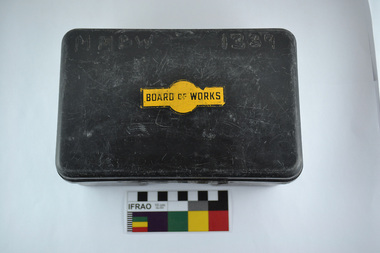 Melbourne Water
First Aid Kit (plastic lunch box), 1970s
... As the Yarra became unsuitable as a source of water, several attempts were made to find alternative sources for the growing population of Melbourne. ...Melbourne Water 990 La Trobe Street Docklands melbourne As the Yarra became unsuitable as a source of water, several attempts were made to find alternative sources for the growing population of Melbourne. ...As the Yarra became unsuitable as a source of water, several attempts were made to find alternative sources for the growing population of Melbourne. It was not until 1891 that the efforts to sewer Melbourne came to fruition with the setting up of the Melbourne Metropolitan Board of Works (MMBW), now known as Melbourne Water. From 1891 until 1992, it was the responsibility of the MMBW to safeguard public health by providing a sewerage system and a safe water supply system. In 1992, The MMBW merged with a number of smaller urban water authorities to form Melbourne Water.This first aid kit is of historical significance for its association with the former Melbourne and Metropolitan Board of Works (MMBW). The kit is relatively intact and a rare surviving object of standard Board issued equipment. The kit is significant for its representativeness of the theme of Safety that continues to resonate strongly within Melbourne Water today. First Aid Kit (plastic lunch box)MMBW 1339 (burnt into plastic) Board of Works Decalmelbourne metropolitan board of works, melbourne water, first aid kit, mmbw, safety, water, sewerage -
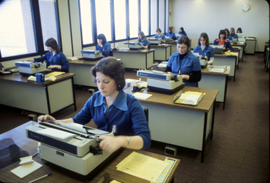 Melbourne Water
Photograph, Typists at the Board, August, 1977
... As the Yarra became unsuitable as a source of water, several attempts were made to find alternative sources for the growing population of Melbourne. ...Melbourne Water 990 La Trobe Street Docklands melbourne As the Yarra became unsuitable as a source of water, several attempts were made to find alternative sources for the growing population of Melbourne. ...As the Yarra became unsuitable as a source of water, several attempts were made to find alternative sources for the growing population of Melbourne. It was not until 1891 that the efforts to sewer Melbourne came to fruition with the setting up of the Melbourne Metropolitan Board of Works (MMBW), now known as Melbourne Water. From 1891 until 1992, it was the responsibility of the MMBW to safeguard public health by providing a sewerage system and a safe water supply system. In 1992, The MMBW merged with a number of smaller urban water authorities to form Melbourne Water. As the MMBW employed men to undertake secretarial work within the first few decades of operation, it wasn't until 1912 when the first female 'typiste' was employed. This photograph, showing a group of typists employed by the Board, is historically significant as it represents the kinds of jobs that women were employed in during the 1970s. Colour Photograph melbourne water, mmbw, melbourne metropolitan board of works, typists, women, administration -
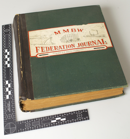 Melbourne Water
MMBW Federation Journal, October 1942 to May 1946
... As the Yarra became unsuitable as a source of water, several attempts were made to find alternative sources for the growing population of Melbourne. ...Melbourne Water 990 La Trobe Street Docklands melbourne As the Yarra became unsuitable as a source of water, several attempts were made to find alternative sources for the growing population of Melbourne. ...As the Yarra became unsuitable as a source of water, several attempts were made to find alternative sources for the growing population of Melbourne. It was not until 1891 that the efforts to sewer Melbourne came to fruition with the setting up of the Melbourne Metropolitan Board of Works (MMBW), now known as Melbourne Water. From 1891 until 1992, it was the responsibility of the MMBW to safeguard public health by providing a sewerage system and a safe water supply system. In 1992, The MMBW merged with a number of smaller urban water authorities to form Melbourne Water.Formally titled, The Official Organ of the Melbourne and Metropolitan Board of Works Employees’ Federation, this series is an exhaustive collection of monthly articles published by MMBW staff. This voluminous collection highlights the accomplishments and social agenda of MMBW employees throughout WWII and its impact on the organisation.mmbw, melbourne metropolitan board of works, journal, articles, staff, 1940s -
 Melbourne Water
Toshiba Two-Way Handheld Radio, 1970s
... As the Yarra became unsuitable as a source of water, several attempts were made to find alternative sources for the growing population of Melbourne. ...Melbourne Water 990 La Trobe Street Docklands melbourne As the Yarra became unsuitable as a source of water, several attempts were made to find alternative sources for the growing population of Melbourne. ...As the Yarra became unsuitable as a source of water, several attempts were made to find alternative sources for the growing population of Melbourne. It was not until 1891 that the efforts to sewer Melbourne came to fruition with the setting up of the Melbourne Metropolitan Board of Works (MMBW), now known as Melbourne Water. From 1891 until 1992, it was the responsibility of the MMBW to safeguard public health by providing a sewerage system and a safe water supply system. In 1992, The MMBW merged with a number of smaller urban water authorities to form Melbourne Water.This item is of historical signficance for its association with the former Melbourne and Metropolitan Board of Works (MMBW). Utilised by MMBW field staff, this is a perfectly intact object of standard Board issued equipment. The two-way hand held radio is signficant for its representativeness of the theme of Technology within the MMBW and Melbourne Water.melbourne metropolitan board of works, mmbw, melbourne water, radio, technology, field, water -
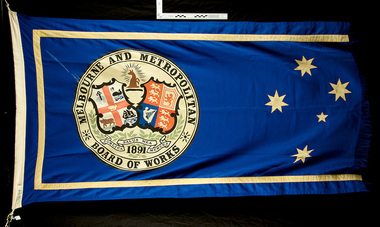 Melbourne Water
Melbourne and Metropolitan Board of Works Flag
... As the Yarra became unsuitable as a source of water, several attempts were made to find alternative sources for the growing population of Melbourne. ...Melbourne Water 990 La Trobe Street Docklands melbourne As the Yarra became unsuitable as a source of water, several attempts were made to find alternative sources for the growing population of Melbourne. ...As the Yarra became unsuitable as a source of water, several attempts were made to find alternative sources for the growing population of Melbourne. It was not until 1891 that the efforts to sewer Melbourne came to fruition with the setting up of the Melbourne Metropolitan Board of Works (MMBW), now known as Melbourne Water. From 1891 until 1992, it was the responsibility of the MMBW to safeguard public health by providing a sewerage system and a safe water supply system. In 1992, The MMBW merged with a number of smaller urban water authorities to form Melbourne WaterThis MMBW flag is of historical significance for its association with the former Melbourne and Metropolitan Board of Works (MMBW). This flag is relatively intact with only two of its kind held in the collection. The flag is significant as is represents a proud organisation and demonstrates the organisations historical development of services, a strong theme of the collection. The flags navy and gold colour is aesthetically pleasing while the coat of arms represented on the flag holds great meaning. Navy and gold Melbourne Metropolitan Board of Works (MMBW) flag with the Southern Cross and MMBW coat of arms. The coat of arms incorporates Melbourne and the United Kingdom, and the motto of the board 'Publica Merces Salus Mea', 'Public Health is my Reward'. mmbw, melbourne water, flag, coat of arms, proud, textile -
 Melbourne Water
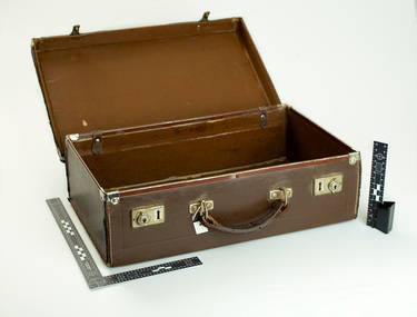
MMBW briefcase, c.1950s
... As the Yarra became unsuitable as a source of water, several attempts were made to find alternative sources for the growing population of Melbourne. ...Melbourne Water 990 La Trobe Street Docklands melbourne As the Yarra became unsuitable as a source of water, several attempts were made to find alternative sources for the growing population of Melbourne. ...As the Yarra became unsuitable as a source of water, several attempts were made to find alternative sources for the growing population of Melbourne. It was not until 1891 that the efforts to sewer Melbourne came to fruition with the setting up of the Melbourne Metropolitan Board of Works (MMBW), now known as Melbourne Water. From 1891 until 1992, it was the responsibility of the MMBW to safeguard public health by providing a sewerage system and a safe water supply system. In 1992, The MMBW merged with a number of smaller urban water authorities to form Melbourne Water.This MMBW briefcase is of historical significance for its association with the former Melbourne and Metropolitan Board of Works (MMBW). This item is perfectly intact and a rare surviving object of standard Board issued accessories. The briefcase is significant for its representativeness of the theme Staff and in building Victoria's industries and workforce, which continues to resonate strongly within Melbourne Water today. The style of this briefcase also demonstrates early 19th century design. MMBW brown leather briefcase with MMBW gold embossed on the lid.mmbw, melbourne metropolitan board of works, melbourne water, briefcase, staff, people, work, water supply -
 Melbourne Water
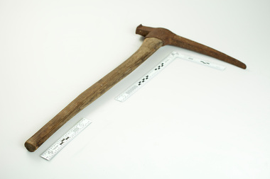
MMBW Hand Tool "Pick"
... As the Yarra became unsuitable as a source of water, several attempts were made to find alternative sources for the growing population of Melbourne. ...Melbourne Water 990 La Trobe Street Docklands melbourne As the Yarra became unsuitable as a source of water, several attempts were made to find alternative sources for the growing population of Melbourne. ...As the Yarra became unsuitable as a source of water, several attempts were made to find alternative sources for the growing population of Melbourne. It was not until 1891 that the efforts to sewer Melbourne came to fruition with the setting up of the Melbourne Metropolitan Board of Works (MMBW), now known as Melbourne Water. From 1891 until 1992, it was the responsibility of the MMBW to safeguard public health by providing a sewerage system and a safe water supply system. In 1992, The MMBW merged with a number of smaller urban water authorities to form Melbourne Water.This hand tool is of historical significance for its association with the former Melbourne and Metropolitan Board of Works (MMBW). This tool is a rare surviving object of standard Board issued equipment. It is significant for its representativeness of the theme of Technology in building Victoria's industries and workforce, which continues to resonate strongly within Melbourne Water today.MMBW hand tool, "Pick" with wooden handle and 'MMBW 'stamped on the metal head.melbourne water, mmbw, melbourne metropolitan board of works, pick axe, construction, work, staff, equipment, technology -
 Melbourne Water
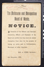
MMBW Notice, 6th November 1903
... As the Yarra became unsuitable as a source of water, several attempts were made to find alternative sources for the growing population of Melbourne. ...Melbourne Water 990 La Trobe Street Docklands melbourne As the Yarra became unsuitable as a source of water, several attempts were made to find alternative sources for the growing population of Melbourne. ...As the Yarra became unsuitable as a source of water, several attempts were made to find alternative sources for the growing population of Melbourne. It was not until 1891 that the efforts to sewer Melbourne came to fruition with the setting up of the Melbourne Metropolitan Board of Works (MMBW), now known as Melbourne Water. From 1891 until 1992, it was the responsibility of the MMBW to safeguard public health by providing a sewerage system and a safe water supply system. In 1992, The MMBW merged with a number of smaller urban water authorities to form Melbourne Water.This MMBW notice is of historical significance for its association with the former Melbourne and Metropolitan Board of Works (MMBW). This item fits under the theme of staff/employees at the MMBW. The Melbourne and Metropolitan Board of Works Notice by direction of the Officers and Servants' Committee,Officers and Employees of the Board are notified that they must not absent themselves from duty for the purpose of taking part in Parliamentary, Municipal, or other Elections. GEO. A. Gibbs, Secretary. melbourne water, mmbw, melbourne metropolitan board of works, notice, work, water -
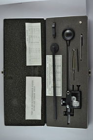 Melbourne Water
Compensating Polar Planimeter, c.1970s
... As the Yarra became unsuitable as a source of water, several attempts were made to find alternative sources for the growing population of Melbourne. ...Melbourne Water 990 La Trobe Street Docklands melbourne As the Yarra became unsuitable as a source of water, several attempts were made to find alternative sources for the growing population of Melbourne. ...As the Yarra became unsuitable as a source of water, several attempts were made to find alternative sources for the growing population of Melbourne. It was not until 1891 that the efforts to sewer Melbourne came to fruition with the setting up of the Melbourne Metropolitan Board of Works (MMBW), now known as Melbourne Water. From 1891 until 1992, it was the responsibility of the MMBW to safeguard public health by providing a sewerage system and a safe water supply system. In 1992, The MMBW merged with a number of smaller urban water authorities to form Melbourne Water. This item was used by MMBW employees as a measuring device to determine areas or figures on a plane surface having either straight or irregular boundaries. The Compensating Polar Planimeter is of historical significance for its association with the former Melbourne and Metropolitan Board of Works (MMBW). This measuring device is perfectly intact and a rare surviving object of standard Board issued equipment. The kit is significant for its representativeness of the theme of Technology in building Victoria's industries and workforce, which continues to resonate strongly within Melbourne Water today.The instrument is inside a black metal case with accessories including: Setting bar, screwdriver, Allen key and spare pole point. Inside is also the adjustable planimeter. mmbw, melbourne water, melbourne metropolitan board of works, technology, instrument, work, measure, historic, water, staff