Showing 231 items matching "water trust"
-
 Buninyong & District Historical Society
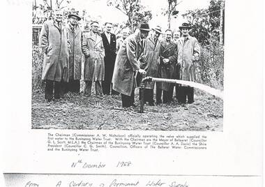
Photograph - Copy of a publication depicting the opening of the Mt Helen valve supplying first water to Buninyong Water Trust 1958, Supplying the first water to Buninyong Water Trust 1958
... Copy of a publication depicting the opening of the Mt Helen valve supplying first water to Buninyong Water Trust 1958...Supplying the first water to Buninyong Water Trust 1958...Buninyong Water Trust...This image depicts the official opening of the permanent water supply for the Buninyong Township and District in 1958 for Buninyong Water Trust...Smith), Councillors, Officers of the Ballaarat Water Commissioners and the Buninyong Water Trust....Buninyong & District Historical Society Old Court House, Buninyong Town Hall 313 Learmonth Street Buninyong goldfields This image depicts the official opening of the permanent water supply for the Buninyong Township and District in 1958 for Buninyong Water Trust This image illustrates the turning on the valve for the first permanent water supply to Buninyong in 1958 Buninyong Water Trust Buninyong water supply Official valve opening The Chairman (Commissioner A. ...This image depicts the official opening of the permanent water supply for the Buninyong Township and District in 1958 for Buninyong Water TrustThis image illustrates the turning on the valve for the first permanent water supply to Buninyong in 1958A black and white photocopy of a photo showing the official opening of the valve supplying the Buninyong Water Commission 1958The Chairman (Commissioner A. W> Nicholson) officially operating the valve which supplied the first water to the Buninyong Water Trust. With the Chairman are the Mayor of Ballaarat Councillor G. L. Scott, M.L.A.) the Chairman of the Buninyong Water Trust (Councillor A. A. Davis) the Sire President (Councillor C. G. Smith), Councillors, Officers of the Ballaarat Water Commissioners and the Buninyong Water Trust.buninyong water trust, buninyong water supply, official valve opening -
 Tatura Irrigation & Wartime Camps Museum
Book, Register of Receipt Books Shire of Rodney Water Trust 1964-1968, 1964-1988
... Register of Receipt Books Shire of Rodney Water Trust 1964-1968...Shire of Rodney Water Trust...Record of receipt books for Shire of Rodney Water Trust, Sewerage Authority, 1964-1988. ...Register of Receipt Books Shire of Rodney Water Trust 1964-1968 Book Book ...Record of receipt books for Shire of Rodney Water Trust, Sewerage Authority, 1964-1988. Black cover, thick cardboard, light brown suede leather spine and corners, red label, silver lettering. 5 pages only.shire of rodney, rodney shire, books, shire of rodney water trust -
 Tatura Irrigation & Wartime Camps Museum
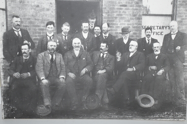
Photograph, Tatura Water Trust
... Tatura Water Trust...tatura water trust...Members and staff of Tatura Water Trust. Identity of 3 men known: Mick Cussen (3rd from left seated), Thomas Hogan ( white beard, seated, legs crossed) and Billie Wilson snr (standing at rear left)....Several hats on the ground in front. Tatura Water Trust Photograph Photograph ...Members and staff of Tatura Water Trust. Identity of 3 men known: Mick Cussen (3rd from left seated), Thomas Hogan ( white beard, seated, legs crossed) and Billie Wilson snr (standing at rear left).Large mounted photograph, black and white of 16 men sitting and standing outside the Trust Office. Some would be Trust members and some staff (probably). The building is brick and window has Secretary's Office printed on it. Several hats on the ground in front.Secretary's Officetatura water trust, mick cussen, thomas hogan, billie wilson snr -
Tatura Irrigation & Wartime Camps Museum
Sign - Notice Board, Rodney Irrigation and Water Supply Trust
... Rodney Irrigation and Water Supply Trust...Rodney Irrigation and Water Supply Trust...Made to commemorate the first meeting of the Rodney Irriagation and Water Supply Trust....Rodney Irrigation and Water Supply Trust First meeting held on 28th May 1889 Commissioners M Cussen Chairman W Bray, M Minter, J Cooke, J Morrisey, T Hogan, J Stewart, M Kavanagh, J Teese, S Lancaster, C W Wilson, J McKenzie Engineer W S Murray Secretary J A Carey...Tatura Irrigation & Wartime Camps Museum 49 Hogan Street Tatura the-murray Made to commemorate the first meeting of the Rodney Irriagation and Water Supply Trust. M Cussen W Bray M Minter J Cooke J Morrissey M Kavanagh J Stewart J Teese S Lancaster C W Wilson J McKenzie W S Murray J A Carey Rodney Irrigation and Water Supply Trust Rodney Irrigation and Water Supply Trust First meeting held on 28th May 1889 Commissioners M Cussen Chairman W Bray, M Minter, J Cooke, J Morrisey, T Hogan, J Stewart, M Kavanagh, J Teese, S Lancaster, C W Wilson, J McKenzie Engineer W S Murray Secretary J A Carey Commemoration Board of dark brown wood with gold writing Rodney Irrigation and Water Supply Trust Sign Notice Board ...Made to commemorate the first meeting of the Rodney Irriagation and Water Supply Trust.Commemoration Board of dark brown wood with gold writingRodney Irrigation and Water Supply Trust First meeting held on 28th May 1889 Commissioners M Cussen Chairman W Bray, M Minter, J Cooke, J Morrisey, T Hogan, J Stewart, M Kavanagh, J Teese, S Lancaster, C W Wilson, J McKenzie Engineer W S Murray Secretary J A Careym cussen, w bray, m minter, j cooke, j morrissey, m kavanagh, j stewart, j teese, s lancaster, c w wilson, j mckenzie, w s murray, j a carey, rodney irrigation and water supply trust -
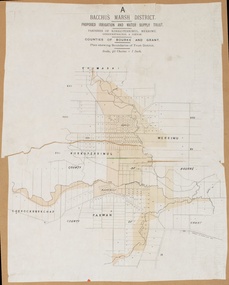
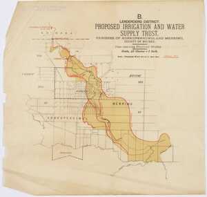
 Bacchus Marsh & District Historical Society
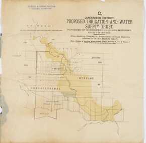
Map, Lerderderg District Proposed Irrigation and Water Supply Trust (C). Plan showing overlap in boundaries of the Trust District
... Lerderderg District Proposed Irrigation and Water Supply Trust (C). Plan showing overlap in boundaries of the Trust District...Lerderderg Irrigation and Water Supply Trust...These local projects were managed by local irrigation trusts. The Lerderderg Irrigation and Water Supply Trust was formed in 1890. ...Printed paper map of the proposed Lerderderg District Irrigation and Water Supply. Plan showing overlap in boundaries of Trust District referred to in Mr Burke's report. ...These local projects were managed by local irrigation trusts. The Lerderderg Irrigation and Water Supply Trust was formed in 1890. ...The 1886 Irrigation Act in Victoria introduced the first legislation in Australia designed to enable the creation of a detailed scheme for agricultural irrigation. Part of the legislation saw the use of government funds for local irrigation projects. These local projects were managed by local irrigation trusts. The Lerderderg Irrigation and Water Supply Trust was formed in 1890. Printed paper map of the proposed Lerderderg District Irrigation and Water Supply. Plan showing overlap in boundaries of Trust District referred to in Mr Burke's report. The Lerderderg District lies within the Parishes of Korkuperrumul and Merrimu in the County of Bourke. At the top of the map above its title is the letter 'C; in capital lettering. A note on this map states: 'Portion of Bacchus MarshUrban District included in area of proposed Trust District shown by hatched shaded lines thus /////////////irrigation, water supply, lerderderg irrigation and water supply trust -
 Bacchus Marsh & District Historical Society
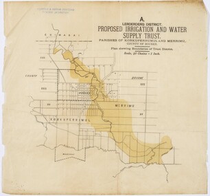
Map, Lerderderg District Proposed Irrigation and Water Supply Trust (A). Plan showing boundaries of Trust District
... Lerderderg District Proposed Irrigation and Water Supply Trust (A). Plan showing boundaries of Trust District....Lerderderg Irrigation and Water Supply Trust...These local projects were managed by local irrigation trusts. The Lerderderg Irrigation and Water Supply Trust] was formed in 1890. ...Printed paper map of the proposed Lerderderg District Irrigation and Water Supply. Plan showing boundaries of Trust District. The Lerderderg District lies within the Parishes of Korkuperrumul and Merrimu in the County of Bourke. ...This map depicts the proposed area of the Trust. Irrigation Water Supply Lerderderg Irrigation and Water Supply Trust Printed paper map of the proposed Lerderderg District Irrigation and Water Supply. ...The 1886 Irrigation Act in Victoria introduced the first legislation in Australia designed to enable the creation of a detailed scheme for agricultural irrigation. Part of the legislation saw the use of government funds for local irrigation projects. These local projects were managed by local irrigation trusts. The Lerderderg Irrigation and Water Supply Trust] was formed in 1890. This map depicts the proposed area of the Trust.Printed paper map of the proposed Lerderderg District Irrigation and Water Supply. Plan showing boundaries of Trust District. The Lerderderg District lies within the Parishes of Korkuperrumul and Merrimu in the County of Bourke. At the top of the map above its title is the letter 'A; in capital lettering. Scale: 40 Chains = 1 inch.irrigation, water supply, lerderderg irrigation and water supply trust -
 Bacchus Marsh & District Historical Society
Map, Bacchus Marsh District (A). Proposed Irrigation and Water Supply Trust. Plan shewing boundaries of Trust District
... Proposed Irrigation and Water Supply Trust. Plan shewing boundaries of Trust District....Bacchus Marsh Irrigation and Water Supply Trust...These local projects were managed by local irrigation trusts. The Bacchus Marsh Irrigation and Water Supply Trust was formed in 1889. ...Printed paper map of the proposed Bacchus Marsh Irrigation and Water Supply district. Circa 1889. Plan showing boundaries of Trust District. ...This map depicts the proposed area of the Trust. Irrigation Water Supply Bacchus Marsh Irrigation and Water Supply Trust Printed paper map of the proposed Bacchus Marsh Irrigation and Water Supply district. ...The 1886 Irrigation Act in Victoria introduced the first legislation in Australia designed to enable the creation of a detailed scheme for agricultural irrigation. Part of the legislation saw the use of government funds for local irrigation projects. These local projects were managed by local irrigation trusts. The Bacchus Marsh Irrigation and Water Supply Trust was formed in 1889. This map depicts the proposed area of the Trust.Printed paper map of the proposed Bacchus Marsh Irrigation and Water Supply district. Circa 1889. Plan showing boundaries of Trust District. The District lies within the Parishes of Korkuperrimul, Merrimu, Parwan and Gorrockburkchap in the Counties of Bourke and Grant. At the top of the map above its title is the letter 'A; in capital lettering. Scale: 40 Chains = 1 inch.irrigation, water supply, bacchus marsh irrigation and water supply trust -
 Warrnambool and District Historical Society Inc.
Administrative record - Warrnambool Water Trust Notebook, late 19th century (1892-1900)
... Warrnambool Water Trust Notebook...This notebook appears to be the Warrnambool Water Trust Records of two contracts in 1892 . ...Administrative record Warrnambool Water Trust Notebook Sands and McDougall - Melbourne ...This notebook appears to be the Warrnambool Water Trust Records of two contracts in 1892 . (The reference is written as 'W.W.Trust'.) The first contract, with the contractors, Coates and Reed, is for the excavation for settling tanks and clear water basin and a reservoir in Liebig Street and there are 60 pages giving details of these works - labour, masonry, concreting, fencing etc. The second contract with the contractor, William Kellas, is for the erection of a cottage and an engine shed and boiler room (7 pages). The Warrnambool Water Trust was set up in 1891 and the first project was the supply of water from the Merri River near Wollaston to a reservoir and tower in Liebig Street and this notebook concerns some details of this early water supply scheme. This notebook is of some interest as it supplies details of a late 19th century Warrnambool water supply scheme and so should be of value to local history researchers This is a notebook with a red leather cover and pages with printed headings and ruled red lines. The pages contain handwriting in black ink. The cover has a label (partly torn) with handwriting.Returns Contracts 1 & 2warrnambool water supply, warrnambool water board, 19th century water in warrnambool -
 Bacchus Marsh & District Historical Society
Map, Lerderderg District Proposed Irrigation and Water Supply Trust (B) Plan Showing Proposed Works
... Lerderderg District Proposed Irrigation and Water Supply Trust (B) Plan Showing Proposed Works...Lerderderg Irrigation and Water Supply Trust...These local projects were managed by local irrigation trusts. The Lerderderg Irrigation and Water Supply Trust was formed in 1890. ...These local projects were managed by local irrigation trusts. The Lerderderg Irrigation and Water Supply Trust was formed in 1890. ...The 1886 Irrigation Act in Victoria introduced the first legislation in Australia designed to enable the creation of a detailed scheme for agricultural irrigation. Part of the legislation saw the use of government funds for local irrigation projects. These local projects were managed by local irrigation trusts. The Lerderderg Irrigation and Water Supply Trust was formed in 1890. This map depicts the proposed area of the Trust and proposed works such as channels and weirs.Printed paper map of the proposed Lerderderg District Irrigation and Water Supply area showing proposed works. The map scale is 40 chains + 1 inch. The Lerderderg District lies within the Parishes of Korkuperrumul and Merrimu in the County of Bourke. At the top of the map above its title is the letter 'B; in capital lettering. A series of proposed channels are indicated on the map in red lines. A proposed weir site and alternative weir site are also indicated on the map. irrigation, water supply, lerderderg irrigation and water supply trust -
Port Melbourne Historical & Preservation Society
Book, Water works, Trust - Inwards Correspondence, 1890s
... Water works, Trust - Inwards Correspondence...Large bound volume, blue with tan leather binding, stamped in gold "Water Works, Trust - Inwards Correspondence", used as visitors' register for the Mission Arts Centre, Missions to Seamen building 1987-89...Missions to Seamen Mission Arts Centre Large bound volume, blue with tan leather binding, stamped in gold "Water Works, Trust - Inwards Correspondence", used as visitors' register for the Mission Arts Centre, Missions to Seamen building 1987-89 Water works, Trust - Inwards Correspondence Book ...Originally a correspondence record for the Warracknabeal Waterworks, this book was recycled for use as a visitors' register for the Missions to Seamen building, during the years the Mission Arts Centre occupied it (1987 - 1990). Included are signatures of visitors during the Bicentenary celebrations, January 1988 as well as casual visitors and attendees at exhibitions, performances, concerts, community days, private parties, etc.Large bound volume, blue with tan leather binding, stamped in gold "Water Works, Trust - Inwards Correspondence", used as visitors' register for the Mission Arts Centre, Missions to Seamen building 1987-89missions to seamen, mission arts centre -
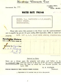 Greensborough Historical Society
Financial record - Account, Hurstbridge Waterworks Trust, Hurstbridge Waterworks Trust water rate assessment 1965-66, 13/05/1965
... Hurstbridge Waterworks Trust water rate assessment 1965-66...Hurstbridge Waterworks Trust water rates accounts for land jointly owned by W.A. ...Greensborough Historical Society 34A Glenauburn Road Lower Plenty Lower Plenty melbourne Hurstbridge Waterworks Trust water rates accounts for land jointly owned by W.A. ...Hurstbridge Waterworks Trust water rates accounts for land jointly owned by W.A. (Alan) Partington and H.V. (Horrie) Burkett for 2 properties in Hurstbridge (Rose Avenue and Daphne Crescent.Alan Partington and Horrie Burkett had a history of joint property ownership from their early days in Warragul.2 Water rates accounts, black text on white paperHandwritten receipt.alan partington, william alan partington, partington family, horrie burkett, hurstbridge, hurstbridge waterworks trust -
Stawell Historical Society Inc
Archive, Shire of Stawell – North East Riding Water Works Trust. Meeting Minutes Book 1882 - 1891, 16/8/1882 - 1/12/1891
... Shire of Stawell – North East Riding Water Works Trust. Meeting Minutes Book 1882 - 1891...Stawell Historical Society Inc 46 Longfield St Stawell grampians Stawell Deep Green Cover - Brown Binding Spine and Corners and Orange Folder Shire of Stawell – North East Riding Water Works Trust. Meeting Minutes Book 1882 - 1891 Archive ...Deep Green Cover - Brown Binding Spine and Corners and Orange Folderstawell -
 Buninyong & District Historical Society
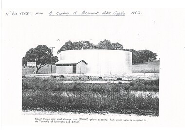
Photograph - Copy of a publication depicting Mount Helen water tank 1958, Mount Helen water tank 1958
... Buninyong Water Trust...This image depicts the opening of the permanent water supply for the Buninyong Township and District in 1958 for Buninyong Water Trust...Buninyong & District Historical Society Old Court House, Buninyong Town Hall 313 Learmonth Street Buninyong goldfields This image depicts the opening of the permanent water supply for the Buninyong Township and District in 1958 for Buninyong Water Trust This image illustrates the turning on the valve for the first permanent water supply to Buninyong in 1958 Buninyong Water Trust Buninyong water supply Mount Helen water storage tank Mount Helen mild steel storage tank, (500,00 gallons capacity) from which water is supplied to the Township of Mount Buninyong and district. ...This image depicts the opening of the permanent water supply for the Buninyong Township and District in 1958 for Buninyong Water TrustThis image illustrates the turning on the valve for the first permanent water supply to Buninyong in 1958A black and white photocopy of a photo showing the 500,000 gallon capacity water tank at Mount HelenMount Helen mild steel storage tank, (500,00 gallons capacity) from which water is supplied to the Township of Mount Buninyong and district.buninyong water trust, buninyong water supply, mount helen water storage tank -
 Warrnambool and District Historical Society Inc.
Financial record - Ledger: Warrnambool Water works Trust, Circa 1900
... Ledger: Warrnambool Water works Trust...water works ledger 1900...warrnambool waterworks trust...water was drawn from the Merri River. Drainage works commenced with the building of the Japan Street tunnel in 1856. The Warrnambool Waterworks Trust...Printed sheet with Warrnambool waterworks Trust is pasted inside front cover. Financial record Ledger: Warrnambool Water works Trust ...This ledger contains entries which relate to waterworks and associated expenses: construction, pumping schemes, water from stand pipes, meter rent arrears, interest payments, pumping scheme. Early residents in Warrnambool relied on tanks and wells for their water supply and in 1880 the first water supply scheme was implemented from a well on Cannon Hill. Using a windmill the water was pumped up and stored in a small reservoir nearby then piped to the corner of Timor and Liebig Streets where a stand pipe allowed the filling of water carts. Similar supplies were also installed at Albert Park, the Botanic Gardens and the Cattle markets and from 1893 to 1939 water was drawn from the Merri River. Drainage works commenced with the building of the Japan Street tunnel in 1856. The Warrnambool Waterworks Trust was the body responsible for administering these works.The supply and storage of fresh water and drainage of the area was an important factor in the development and sustainability of the town. This ledger provides an insight into the daily operations of this organisation. Large suede covered journal. Tan in colour with pink, green and white on edge of pages. Faded black stylised border around front cover. Inside front covers are patterned in green and tan. Printed sheet with Warrnambool waterworks Trust is pasted inside front cover. Warrnambool Waterworks Trust stamp on sheet inside front cover.warrnambool water works, warrnambool water supply 1900, warrnambool water works ledger 1900, warrnambool waterworks trust -
Tatura Irrigation & Wartime Camps Museum
Photograph, Clark D, 1989
... ...Water Trust...Murray, engineer, surveyor. Water Trust office, Dr's residence, J. Reilly's residence. ...Murray, engineer, surveyor. Water Trust office, Dr's residence, J. Reilly's residence. ...49 Hogan street Tatura, office of W. S. Murray, engineer, surveyor. Water Trust office, Dr's residence, J. Reilly's residence. Present Museum.Black and white photograph of 6 men and surveying equipment outside 49 Hogan street Tatura.on building - Walter Scott Murraywalter scott murray, water trust, museum -
 Bendigo Historical Society Inc.
Certificate - Thank You Award
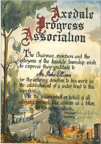
... ...Axedale Water Trust...John Ellison expressing gratitude for his work in establishing a Water Trust for the town of Axedale. Signed by John A Colvin and W J Burns on behalf of the Axedale Progress Association. ...History House 11 Mackenzie Street Bendigo goldfields John Ellison Axedale Progress Association Axedale Water Trust Handwritten coloured certificate presented to Mr. ...Handwritten coloured certificate presented to Mr. John Ellison expressing gratitude for his work in establishing a Water Trust for the town of Axedale. Signed by John A Colvin and W J Burns on behalf of the Axedale Progress Association. Includes illustrations of Axedale and the bridge over the Campaspe River. Undated. removed from frame for storage. Certificate enclosed in a cardboard frame (3 cm) Aileen and John Ellison Collection.john ellison, axedale progress association, axedale water trust -
 Otway Districts Historical Society
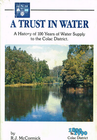
Book, A trust in water, 1990
... A trust in water....a trust in water; r.j. mccormick; colac; water resources; sewerage; west gellibrand dam; otways;...A trust in water. A history of 100 years of water supply to the Colac district. ...Otway Districts Historical Society Cliff Young Drive Beech Forest great-ocean-road The harnessing of the bountiful water resources of the Otways as a critical element in the urban and agricultural development of the Colac region. a trust in water; r.j. mccormick; colac; water resources; sewerage; west gellibrand dam; otways; A trust in water. ...The harnessing of the bountiful water resources of the Otways as a critical element in the urban and agricultural development of the Colac region.A trust in water. A history of 100 years of water supply to the Colac district. R.J. McCormick. 1st ed. np; R.J. McCormick; 1990. xxii, 324 p.; illus, map. Hard cover. ISBN 0 7241968 2 X a trust in water; r.j. mccormick; colac; water resources; sewerage; west gellibrand dam; otways; -
Tatura Irrigation & Wartime Camps Museum
Folder, Early Irrigation Trusts, 1990
... Clear plastic folder containing information on Echuca, Waranga and Rodney Irrigation Water Trusts....Tatura Irrigation & Wartime Camps Museum 49 Hogan Street Tatura the-murray "History of Irrigation in the Goulburn-Murray Irrigation District"- Paper presented at Echuca 1990 by Bruce Campbell. 1990 Regional Conference water books history local irrigation Clear plastic folder containing information on Echuca, Waranga and Rodney Irrigation Water Trusts. Early Irrigation Trusts Folder ..."History of Irrigation in the Goulburn-Murray Irrigation District"- Paper presented at Echuca 1990 by Bruce Campbell. 1990 Regional ConferenceClear plastic folder containing information on Echuca, Waranga and Rodney Irrigation Water Trusts.water, books, history, local, irrigation -
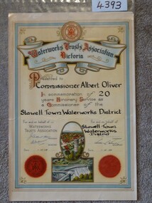 Stawell Historical Society Inc
Memorabilia - Realia, 1958
... 20 Year Service Certificate - Albert Oliver - (Water Trust Association of Victoria) 1958...Stawell Historical Society Inc 46 Longfield St Stawell grampians stawell 20 Year Service Certificate - Albert Oliver - (Water Trust Association of Victoria) 1958 Memorabilia Realia ...20 Year Service Certificate - Albert Oliver - (Water Trust Association of Victoria) 1958stawell -
 Bendigo Historical Society Inc.
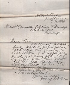
Document - CONNELLY, TATCHELL, DUNLOP COLLECTION: MORTGAGE MR. GEORGE LADSON TO T. LUXTON
... Irrigation and Water Supply Trust...Letters from Connelly, Tatchell & Dunlop, Thomas Luxton, Irrigable Estate Company, Irrigation & Water supply Trust, George Welch, Railway Hotel, Macorna, draft of document which includes name of John Quick ( unsigned )...History House 11 Mackenzie Street Bendigo goldfields COTTAGE Miners George Ladson Thomas Luxton John Quick Connelly & Tatchell Macorna Irrigation and Water Supply Trust Tragowel Mortgage document ( 19 August 1892 ) and related correspondence between Mr. ...Mortgage document ( 19 August 1892 ) and related correspondence between Mr. George Ladson to Mr. T. Luxton Esq. re purchase of land in Parish of Macorna, County of Gunbower. Includes transfer of land between The Irrigable Estate Coy, to Mr. George Ladson. Letters from Connelly, Tatchell & Dunlop, Thomas Luxton, Irrigable Estate Company, Irrigation & Water supply Trust, George Welch, Railway Hotel, Macorna, draft of document which includes name of John Quick ( unsigned )cottage, miners, george ladson, thomas luxton, john quick, connelly & tatchell, macorna, irrigation and water supply trust, tragowel -
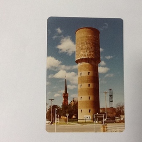 Port of Echuca
Colour Photograph, Approx.1979
... On the front of the photograph on the bottom facade of the water tower is painted "E.W.T." (Echuca Water Trust). Printed on the reverse:" this paper manufactured by Kodak"...As well as these contributions to social development, he was also a war hero. echuca, water tower echuca-historical buildings monash, sir john reinforced concrete building construction On the front of the photograph on the bottom facade of the water tower is painted "E.W.T." (Echuca Water Trust). Printed on the reverse:" this paper manufactured by Kodak" Colour photograph of water tower on the south east corner of High and Pakenham street, Echuca. ...The water tower on the corner of Pakenham St and High Street Echuca, was designed by Sir John Monash, who was an innovator in the use of reinforced concrete. The tower cost £2,973 and was completed in 1915. It is 108 feet high and holds 150,000 gallons. it was originally connected to the steam powered pumping plant at Echuca East. John Monash was a war hero at Gallipoli in 1915 and also went on to be the Manager of the Victorian State Electricity Commission. Monash University was named after him.The water tower was a revolutionary design in 1915., being constructed of reinforced concrete. It also brought tapped water to people's homes. Sir John Monash made a huge contribution to engineering and social concepts, which was why he was knighted. As well as these contributions to social development, he was also a war hero. Colour photograph of water tower on the south east corner of High and Pakenham street, Echuca. The St Andrews church tower can be seen in the background.On the front of the photograph on the bottom facade of the water tower is painted "E.W.T." (Echuca Water Trust). Printed on the reverse:" this paper manufactured by Kodak"echuca, water tower, echuca-historical buildings, monash, sir john, reinforced concrete building construction -
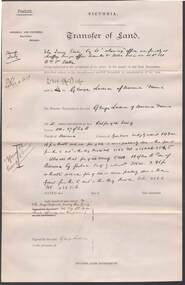
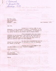 Bendigo Historical Society Inc.
Document - BENDIGO SALEYARDS COLLECTION: LETTERS
... The Geelong Water & Sewerage Trust...Quoted are payments made by the Geelong Water & Sewerage Trust to their workers at the end of the First Year, Third Year, Fifth Year and Eighth Year....Quoted are payments made by the Geelong Water & Sewerage Trust to their workers at the end of the First Year, Third Year, Fifth Year and Eighth Year. ...Two letters (stapled together) from T H Williams, Country Organiser from the Federated Municipal and Shire Council Employees' Union of Australia - Victorian Division, one to The Town Clerk (pink copy) and the other to J Richmond. The Town Clerk's letter, dated 21/12/1978 refers to the replacement of a 20' extension ladder, electric power leads, and new oilskin wet weather gear. Signed by T H Williams. The letter to J Richmond, dated 20/12/1978 mentions Service Grants to the workers. Quoted are payments made by the Geelong Water & Sewerage Trust to their workers at the end of the First Year, Third Year, Fifth Year and Eighth Year.bendigo, council, cattle markets, bendigo saleyards collection - letters, city of bendigo, j richmond, norm harris, t h williams, federated municipal and shire employees' union of australia - victorian division, the geelong water & sewerage trust -
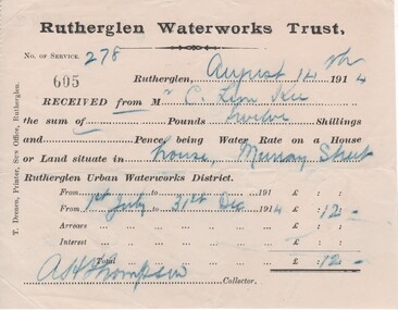 Rutherglen Historical Society
Financial record - Receipt, T. Drenen, 14/8/1914 (Exact)
... rutherglen waterworks trust...water...Receipt from Rutherglen Waterworks Trust for water rates for a house in Murray Street. ...Trust, No. of service 278. [receipt no.]: 605. Rutherglen, August 14th 1914. Received from Mr C. Lim Kee the sum of --- Pounds twelve Shillings and --- Pence, being Water Rate on a House or Land situate in house, Murray Street Rutherglen Urban Waterworks District. ...The location (134 Main Street) is currently (2022) occupied by Miegel’s Pharmacy Rutherglen. lim kee rutherglen waterworks trust water rates business documents 134 Main Street Chambers Riteway Supermarket "Rutherglen Waterworks Trust, No. of service 278. ...It is believed that the C. Lim Kee who was paying these rates was Charles Lim Kee. According to the Rutherglen Sun September 11, 1896 he was starting a business known as the Cash Bakery in premises previously occupied by Conrad Huhs. In 1903 he moved to new premises next to the Bank of Victoria. By 1908 he had a shop and rooms in Main Street, and houses in Wallace Street and Murray Street. Part of a collection of business documents found under the floor of a building in Main Street when it was being renovated. At that time the owner was Don Chambers, and the premises was occupied as the Chambers Riteway Supermarket. The location (134 Main Street) is currently (2022) occupied by Miegel’s Pharmacy Rutherglen. Receipt from Rutherglen Waterworks Trust for water rates for a house in Murray Street. The form is printed on paper with hand written details reproduced with carbon paper.,"Rutherglen Waterworks Trust, No. of service 278. [receipt no.]: 605. Rutherglen, August 14th 1914. Received from Mr C. Lim Kee the sum of --- Pounds twelve Shillings and --- Pence, being Water Rate on a House or Land situate in house, Murray Street Rutherglen Urban Waterworks District. From 1st July to 31st Dec 1914." Signed A.H. Thompson, Collector.lim kee, rutherglen waterworks trust, water rates, business documents, 134 main street, chambers riteway supermarket -
 Bendigo Historical Society Inc.
Document - CONNELLY, TATCHELL, DUNLOP COLLECTION: LEGAL PAPERS, 1896
... Tragowel Plains Irrigation & Water Supply Trust...2 - 1896 - Letter from Bell J, Secretary, Trust Office, Mincha, Tragowel Plains Irrigation & Water Supply Trust. ...2 - 1896 - Letter from Bell J, Secretary, Trust Office, Mincha, Tragowel Plains Irrigation & Water Supply Trust. ...Documents. Connelly, Tatchell & Dunlop. 1 - 1896 - Letter from Attenborough, Nunn & Smith, Melbourne. Mentions O'Connell v Frizzell? 2 - 1896 - Letter from Bell J, Secretary, Trust Office, Mincha, Tragowel Plains Irrigation & Water Supply Trust. Dated Feb 7 1896. 3 - 1896 - Letter from Melbourne Office to Bendigo Office re Proctor & Braybrook. 4 - 1896 - Letter from Myrtleford - payment for fortnights rent. 5 - 1896 - Letter from Melbourne Office to Bendigo Office re Agency costs. 6 - 1896 - Letter from Browne John, Kyabram. 7 - 1896 - Letter from Sheridan William F, Mildura re Irrigable Estates v Sheridan.cottage, miners, connelly, tatchell & dunlop, attenborough nunn & smith, o'connell, frizzell?, bell j, tragowel plains irrigation & water supply trust, proctor, braybrook, browne john, sheridan william f, irrigable estates -
 Bendigo Historical Society Inc.
Newspaper - Newspaper cuttings
... ...Axedale Water Trust...Water scheme opened April 1964 with the trust being created by the Governor in Council. ...water supply to Axedale. Also included are notice of meetings of the Axedale Waterworks Trust with financial statements for 1963 and 1964. ...Axedale Axedale Water Trust On the cover School Committee' book of school..... at.... ...Water scheme opened April 1964 with the trust being created by the Governor in Council. It consisted of 3 councillors from Axedale and 3 members appointed by the Minister of Water Supply.A grey exercise book containing newspaper cuttings relating to the progress of getting the water supply to Axedale. Also included are notice of meetings of the Axedale Waterworks Trust with financial statements for 1963 and 1964. A letter dated 2nd March 1964 addressed to Mr. J. Ellison from L.G. Houston (Private secretary to the Minister of water supply W.J Mibus) is also in the book. Aileen and John Ellison Collection.On the cover School Committee' book of school..... at....axedale, axedale water trust -
 Bendigo Historical Society Inc.
Financial record - Axedale Waterworks Trust
... Axedale Water Trust...History House 11 Mackenzie Street Bendigo goldfields Axedale Water Trust Financial record Collection of documents pertaining to the Axedale Waterworks Trust. ...Collection of documents pertaining to the Axedale Waterworks Trust. The documents range in date from 1963 to 1968 and covers: Audit reports, Chairman letters to shareholders, financial statements, land reports. Aileen and John Ellison Collection.axedale water trust, financial record -
Tatura Irrigation & Wartime Camps Museum
Document, Municipal Directory - 1890 - Extracts
... ...water...trust...Tatura Irrigation & Wartime Camps Museum 49 Hogan Street Tatura the-murray Report of meeting at Trust Office, Shire Hall, Rushworth, 1882 irrigation water trust members documents Blue and clear plastic folder. ...Report of meeting at Trust Office, Shire Hall, Rushworth, 1882Blue and clear plastic folder. Metal fasteners.irrigation, water, trust members, documents -
Tatura Irrigation & Wartime Camps Museum
Book - Family History, My Journey - Charles Gerrish, 2000
... ...mooroopna water trust...Including family history, farming, many activities in local government. gerrish family mooroopna water trust Charles Gerrish Gerrish Family History Blue cover, title in white writing, some gold. 1910 - 2000. ...Life story of Charles Gerrish, as told to his granddaughter-in-law. Including family history, farming, many activities in local government.Blue cover, title in white writing, some gold. 1910 - 2000. Photograph of C Gerrish and tree on front. On back cover - tributes from B McCarthy and D McPherson.gerrish family, mooroopna water trust, charles gerrish, gerrish family history -
 Bendigo Historical Society Inc.
Document - CONNELLY, TATCHELL, DUNLOP COLLECTION: LEGAL PAPERS, 1896
... Tragowel Plains Irrigation & Water Supply Trust...Mentions Fairclough & Brown. 7 - 1896 - memo from Kerang Office to Bendigo Office re Grigg v Patterson. 8 - 1896 - Memo from Kerang Office to Bendigo Office re Moylan to Perry. 9 - 1896 - Letter from Bell J, Secretary, Trust Office, Mincha, Tragowel Plains Irrigation and Water Supply Trust. ...Mentions Fairclough & Brown. 7 - 1896 - memo from Kerang Office to Bendigo Office re Grigg v Patterson. 8 - 1896 - Memo from Kerang Office to Bendigo Office re Moylan to Perry. 9 - 1896 - Letter from Bell J, Secretary, Trust Office, Mincha, Tragowel Plains Irrigation and Water Supply Trust. ...Documents. Connelly, Tatchell & Dunlop. 1 - 1896 - Letter from Roche Mary re debt. 2 - 1896 - Letter from Dean A F, 'Yambuna', Tongala Rly Stn, Victoria. 3 - 1896 - Letter from Bryan J W re Bartlett Bros. 4 - 1896 - Letter from Sims D re Dwyer. 5 - 1896 - Letter from McKinnoz? Arch M. Mentions names Fairclough & Brown. 6 - 1896 - Letter from Moylan T F. Mincha. Mentions Fairclough & Brown. 7 - 1896 - memo from Kerang Office to Bendigo Office re Grigg v Patterson. 8 - 1896 - Memo from Kerang Office to Bendigo Office re Moylan to Perry. 9 - 1896 - Letter from Bell J, Secretary, Trust Office, Mincha, Tragowel Plains Irrigation and Water Supply Trust. Dated Feb 29 1896.cottage, miners, connelly, tatchell & dunlop, roche mary, dean a f, bryan j w, bartlett bros, sims d, dwyer, mckinnoz? arch m, fairclough, brown, moylan t f, grigg, patterson, moylan, perry, bell j, tragowel plains irrigation & water supply trust -
 Bendigo Historical Society Inc.
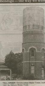
Newspaper - JENNY FOLEY COLLECTION: TALL ORDER
... Tall order: Elmore urban water tower, built 1891 by Elmore Water Trust. The clip is in a folder....Tall order: Elmore urban water tower, built 1891 by Elmore Water Trust. The clip is in a folder. Newspaper JENNY FOLEY COLLECTION: TALL ORDER ...Bendigo Advertiser ''The way we were'' from 2000. Tall order: Elmore urban water tower, built 1891 by Elmore Water Trust. The clip is in a folder.newspaper, bendigo advertiser, the way we were