Showing 1420 items matching "waterways"
-
 Greensborough Historical Society
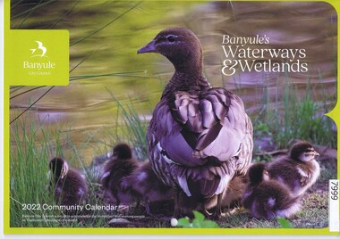
Calendar, Banyule City Council, Banyule Community Calendar 2022: Banyule's Waterways & Wetlands, 2022
... Banyule Community Calendar 2022: Banyule's Waterways & Wetlands...The 2022 calendar contains action photographs of local waterways and wetlands. Some council services are detailed in the back pages....Illustrations of local waterways and wetlands. ...Illustrations of local waterways and wetlands. Banyule Community Calendar 2022: Banyule's Waterways & Wetlands Calendar Banyule City Council ...This community calendar is distributed to residents of the City of Banyule each year. Each year it focusses on an aspect of the local community. The 2022 calendar contains action photographs of local waterways and wetlands. Some council services are detailed in the back pages.The annual report is a record of the activities and services in the Banyule City Council area.30 pages. Colour illustrations. Illustrations of local waterways and wetlands. banyule city council, banyule community calendar, rivers, wetlands -
 Greensborough Historical Society
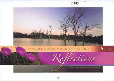
Calendar, Banyule City Council, Banyule Community Calendar 2007: Reflections - Banyule's waterways, native flora and fauna, 2007_
... Banyule Community Calendar 2007: Reflections - Banyule's waterways, native flora and fauna....The 2007 calendar contains photographs of Banyule's waterways, native flora and fauna. Some council services are detailed in the back pages...Colour illustrations of Banyule's waterways, native flora and fauna...Colour illustrations of Banyule's waterways, native flora and fauna Banyule Community Calendar 2007: Reflections - Banyule's waterways, native flora and fauna. ...This community calendar is distributed to residents of the City of Banyule each year. Each year it focusses on an aspect of the local community. The 2007 calendar contains photographs of Banyule's waterways, native flora and fauna. Some council services are detailed in the back pagesThe annual calendar is a record of the activities and services in the Banyule City Council area28 pages. Colour illustrations of Banyule's waterways, native flora and faunabanyule city council, banyule community calendar -
 Tatura Irrigation & Wartime Camps Museum
Book, Nagambie Waterways The way they were, May 2009
... Nagambie Waterways The way they were...History of the Goulburn Irrigation System and the waterways....There are 92 pages with many B/W photos detailing the history of the waterways....There are 92 pages with many B/W photos detailing the history of the waterways. Nagambie Waterways The way they were Book Elaine Lodding ...History of the Goulburn Irrigation System and the waterways.Collection of early photographs of the area telling the history.Rectangular shaped book, Cover is a B/W photo of the 'Merriwee', boat, owned by W. L Forbes C 1920 with a group of people on board about to enjoy a sailing. There are 92 pages with many B/W photos detailing the history of the waterways.Credits page, supported by the Strathbogie Shire Council.and Nagambie Historical Society.irrigation history, lake nagambie, goulburn weir and environs, life in the area -
Greensborough Historical Society
Report, Melbourne Parks and Waterways, Happy Hollow Farm Complex : Conservation Strategy [excerpts], 1996_07
... This report was commissioned by the Melbourne Parks and Waterways in 1996. It contains a history of the place and building, and garden and landscape features. ...Melbourne Parks and Waterways...Happy Hollow Farm Complex : Conservation Strategy [excerpts] Report Melbourne Parks and Waterways ...This report was commissioned by the Melbourne Parks and Waterways in 1996. It contains a history of the place and building, and garden and landscape features. There is a Statement of Cultural Heritage Significance. Happy Hollow was occupied (and probably built) by Emmett Whatmough in 1893, and owned by John Cully McLaughlin. There are other family connections among the Greensborough district pioneers.Copy of document, 16 pages plus maps.happy hollow, whatmough, bell, mclaughlin, melbourne parks and waterways. cultural heritage significance -
Save the Dandenongs League Inc.
Archive (item), Save the Dandenongs League Incorporated, Melbourne Parks & Waterways - Annual Review - 1996
... Melbourne Parks & Waterways - Annual Review - 1996...Melbourne Parks & Waterways - Annual Review - 1996 Archive Save the Dandenongs League Incorporated ... -
Save the Dandenongs League Inc.
Archive (item), Save the Dandenongs League Incorporated, Parks and Waterways [Suspension File]
... Parks and Waterways [Suspension File]...Parks and Waterways [Suspension File] Archive Save the Dandenongs League Incorporated ... -
Tatura Irrigation & Wartime Camps Museum
Book, Elaine Lodding et al, Nagambie Waterways and the Way They Were, May 2009
... Nagambie Waterways and the Way They Were...White back cover. Nagambie Waterways and the Way They Were Book Elaine Lodding Euroa Printers ...Includes many historical photographs and history of Nagambie and importance of Goulburn Weir.Cover photograph of boating scene. "Merriwee" owned by W. L. Forbese 1920. White back cover.goulburn weir -
University of Melbourne, Burnley Campus Archives
Article, W.T. Parsons, Water Hyacinth a pest of world waterways, 1964
... Water Hyacinth a pest of world waterways...Parsons from Journal of the Department of Agriculture. 3 copies Water Hyacinth a pest of world waterways Article W.T. Parsons ...Reprint of article by W.T. Parsons from Journal of the Department of Agriculture. 3 copiesdepartment of agriculture, w.t. parsons -
Kew Historical Society Inc
Archive (Sub-series) - Subject File, Creeks and Waterways (Kew), 1958
... Creeks and Waterways (Kew)...Archive file containing an article on creeks in Balwyn from a Balwyn HS newsletter (O’Dwyer, P., 2010) and a newspaper article/clipping on Glass Creek (2012). Creeks and Waterways (Kew) Archive Subject File ...Various partiesReference, Research, InformationSecondary Values (KHS Imposed Order)Subject file containing an article on creeks in Balwyn from a Balwyn HS newsletter (O’Dwyer, P., 2010) and a newspaper article/clipping on Glass Creek (2012).creeks -- kew (vic.)creeks -- kew (vic.) -
 Eltham District Historical Society Inc
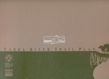
Book, D. Pendavingh, Yarra River Trail Plan 1989: Banksia Street to Warrandyte, 1989
... ...Waterways & Parks Division Board of Works...Also loose A3 mylar plan inserted Yarra River Trail Plan 1989: Banksia Street to Warrandyte Book Book D. Pendavingh Waterways & Parks Division Board of Works ...Also contains a loose A3 mylar plan inserted - Depart of Planning and Urban Growth, Heidelberg; Main Yarra Trail; Warringal Parklands and Banyule Flats, Detail Plan and Locality Plan -
 Eltham District Historical Society Inc
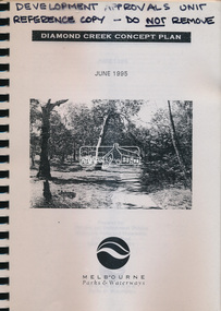
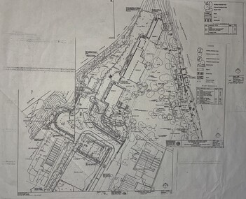
Book, Melbourne Parks & Waterways, Diamond Creek Concept Plan, June 1995
... Melbourne Parks & Waterways...Eltham District Historical Society Inc 728 Main Rd Eltham melbourne A4 spiral bound, 38 plages plus appendices and fold out A3 maps Diamond Creek Concept Plan Book Book Melbourne Parks & Waterways ... -
 Heidelberg Golf Club
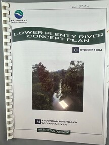
Book, Melbourne Parks and Waterways, Lower Plenty River concept plan: Maroondah Pipe Track to Yarra River, 1994
... Melbourne Parks and Waterways...Lower Plenty River concept plan: Maroondah Pipe Track to Yarra River Book Book Melbourne Parks and Waterways ...Lower Plenty River concept plan: Maroondah Pipe Track to Yarra River. Includes suggestion of Plenty River Trail along the west boundary of the Heidelberg Golf Club.66 p., illus., colour map. Also, Draft copy of document.plenty river trail, lower plenty river, heidelberg golf club, mmbw, melbourne parks and waterways -
 Sunshine and District Historical Society Incorporated
Plan - Plan of Pipe Makers Park, Waterways & Parks division of Melbourne Metropolitan Board of Works, 1987
... Waterways & Parks division of Melbourne Metropolitan Board of Works...Pipe Makers Park Park Maribyrnong Plan of Pipe Makers Park area including landscape and planting concept 1987 Plan Plan of Pipe Makers Park Waterways & Parks division of Melbourne Metropolitan Board of Works ...pipe makers, park, park, maribyrnong -
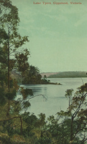
 Lakes Entrance Historical Society
Photograph - Lake Tyers Victoria c1905, Caire, Nicholas John, 1905c
... Waterways...View of one of the lakes on the Lake Tyers river system showing a calm waterway and timbered banks Small paddle boat 'Sunbeam' used as tourist launch...Black and white photograph of a view of one of the lakes on the Lake Tyers system showing a calm waterway and densely timbered banks. There is a small steamboat anchored in the lake. ...Lakes Entrance Historical Society 4 Marine Parade Lakes Entrance gippsland View of one of the lakes on the Lake Tyers river system showing a calm waterway and timbered banks Small paddle boat 'Sunbeam' used as tourist launch Waterways Boats and Boating Tourism Black and white photograph of a view of one of the lakes on the Lake Tyers system showing a calm waterway and densely timbered banks. ...View of one of the lakes on the Lake Tyers river system showing a calm waterway and timbered banks Small paddle boat 'Sunbeam' used as tourist launchBlack and white photograph of a view of one of the lakes on the Lake Tyers system showing a calm waterway and densely timbered banks. There is a small steamboat anchored in the lake. Lake Tyers Victoriawaterways, boats and boating, tourism -
 Sunshine and District Historical Society Incorporated
Archive - Natural Enviroment
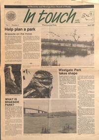
... Collection of documents relating to the enviroment and waterways...2297.01 - Bulletin Volume 1 Number 2 Melbourne and Metropolitan Board of Works In Touch Waterways and Parks April 1987|2297.02 - Extract A Rescue Operation for Kororoit Creek Finding a New Lease of Life for neglected urban waterways|2297.03 - Typed Report State Rivers and Water Supply Commission Press Release The Status of Rivers|2297.04 - Letter Enviroment Protection Authority of Victoria 9 June 1982 To Objectors against S.C.I. ...Creek 2297.01 - Bulletin Volume 1 Number 2 Melbourne and Metropolitan Board of Works In Touch Waterways and Parks April 1987|2297.02 - Extract A Rescue Operation for Kororoit Creek Finding a New Lease of Life for neglected urban waterways|2297.03 - Typed Report State Rivers and Water Supply Commission Press Release The Status of Rivers|2297.04 - Letter Enviroment Protection Authority of Victoria 9 June 1982 To Objectors against S.C.I. ...2297.01 - Bulletin Volume 1 Number 2 Melbourne and Metropolitan Board of Works In Touch Waterways and Parks April 1987|2297.02 - Extract A Rescue Operation for Kororoit Creek Finding a New Lease of Life for neglected urban waterways|2297.03 - Typed Report State Rivers and Water Supply Commission Press Release The Status of Rivers|2297.04 - Letter Enviroment Protection Authority of Victoria 9 June 1982 To Objectors against S.C.I. Meat & Paper Pty Ltd to discharge waste to air Dohertys Road Laverton North|2297.05 - Talk for SGAP Keilor Plains Group - Managing the natural assets of Brimbank - Sites of biological significance as identified in the Brimbank Natural Heritage Strategycreek -
 Surrey Hills Historical Society Collection
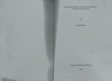
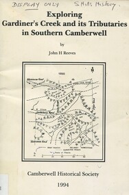
Book, Exploring Gardiner's Creek and its tributaries in southern Camberwell, 1994
... This book describes geographical landmarks and especially waterways that of the City of Camberwell (now City of Boroondara)....This book describes geographical landmarks and especially waterways that of the City of Camberwell (now City of Boroondara)....Surrey Hills Historical Society Collection 190A Canterbury Road Canterbury melbourne This book describes geographical landmarks and especially waterways that of the City of Camberwell (now City of Boroondara). gardiner's creek (mr) john gardiner koonung creek back creek glass's creek w creek west creek ashburton creek delaney's creek walking trails rivers This book describes geographical landmarks and especially waterways that of the City of Camberwell (now City of Boroondara). ...This book describes geographical landmarks and especially waterways that of the City of Camberwell (now City of Boroondara).This book describes geographical landmarks and especially waterways that of the City of Camberwell (now City of Boroondara).gardiner's creek, (mr) john gardiner, koonung creek, back creek, glass's creek, w creek, west creek, ashburton creek, delaney's creek, walking trails, rivers -
 Lakes Entrance Historical Society
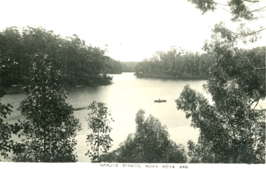
Photograph - Rippling Straits, Nowa Nowa Arm
... Waterways...Black and white digital photo of waterways with a canoe...Waterways Topography Rippling Straits, Nowa Nowa Arm Black and white digital photo of waterways with a canoe Photograph Rippling Straits, Nowa Nowa Arm ...Black and white digital photo of waterways with a canoeRippling Straits, Nowa Nowa Armwaterways, topography -
 Surrey Hills Historical Society Collection
Book, Exploring Gardiner's Creek and its tributaries in southern Camberwell, 1994
... This book describes geographical landmarks, in particular the waterways, that make up the City of Camberwell (now City of Boroondara)....This book describes geographical landmarks, in particular the waterways, that make up the City of Camberwell (now City of Boroondara)....Surrey Hills Historical Society Collection 190A Canterbury Road Canterbury melbourne This book describes geographical landmarks, in particular the waterways, that make up the City of Camberwell (now City of Boroondara). gardiner's creek (mr) john gardiner koonung creek back creek glass's creek w creek west creek ashburton creek delaney's creek walking trails rivers creeks glass creek This book describes geographical landmarks, in particular the waterways, that make up the City of Camberwell (now City of Boroondara). ...This book describes geographical landmarks, in particular the waterways, that make up the City of Camberwell (now City of Boroondara).This book describes geographical landmarks, in particular the waterways, that make up the City of Camberwell (now City of Boroondara).gardiner's creek, (mr) john gardiner, koonung creek, back creek, glass's creek, w creek, west creek, ashburton creek, delaney's creek, walking trails, rivers, creeks, glass creek -
Lakes Entrance Historical Society
Map - Lake Tyers Forest and Waterways
... ...Waterways...Map of Lake Tyers showing forest and waterways....Map Lake Tyers Forest and Waterways ...Map of Lake Tyers showing forest and waterways.forest, waterways, highways -
Lakes Entrance Historical Society
Map - Plan of Township of Lakes Entrance
... ...Waterways...Plan of township of Lakes Entrance showing waterways and land owners...Lakes Entrance Historical Society 4 Marine Parade Lakes Entrance gippsland Township Waterways Maps Plan of township of Lakes Entrance showing waterways and land owners Map Plan of Township of Lakes Entrance ...Plan of township of Lakes Entrance showing waterways and land ownerstownship, waterways, maps -
 Lakes Entrance Historical Society
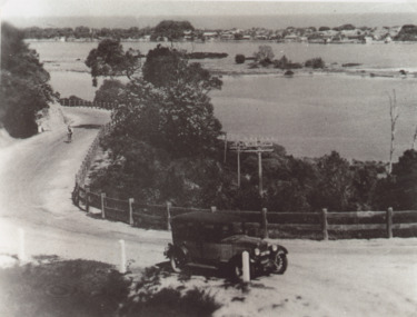
Photograph - Princes Highway around Jemmys Point, Lakes Entrance, H D Bulmer, 1930 c
... ... Waterways...Bullock Island and New Works in distance over North Arm and Cunninghame Arm waterways Lakes Entrance Victoria...Bullock Island and New Works in distance over North Arm and Cunninghame Arm waterways Lakes Entrance Victoria...Bullock Island and New Works in distance over North Arm and Cunninghame Arm waterways Lakes Entrance Victoria Roads and Streets Township Waterways Fences Vehicles Black and white photograph of lower section of Princes Highway around Jemmys Point, car parked on road at junction of original steep road to top of Jemmys Point. ...Princes Highway around Jemmys Point, car parked on road at junction of original steep road to top of Jemmys Point. Man on bicycle riding up hill. Bullock Island and New Works in distance over North Arm and Cunninghame Arm waterways Lakes Entrance VictoriaBlack and white photograph of lower section of Princes Highway around Jemmys Point, car parked on road at junction of original steep road to top of Jemmys Point. Man on bicycle riding up hill. Bullock Island and New Works in distance over North Arm and Cunninghame Arm waterways Lakes Entrance Victoriaroads and streets, township, waterways, fences, vehicles -
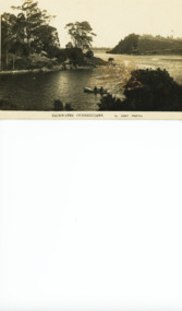
 Lakes Entrance Historical Society
Postcard - Lake Tyers, Valentine Series 1071, 1905c
... ... Waterways...Tinted postcard of waterway surrounded by thick timber, small steamer on water. ...Lakes Entrance Historical Society 4 Marine Parade Lakes Entrance gippsland Also tinted postcard Lake Tyers Gippsland by same maker, number 03822.1 size 13.5 x 9 cm also purchased from B Roche Forest Waterways Lake Tyers Gippsland Victoria Tinted postcard of waterway surrounded by thick timber, small steamer on water. ...Also tinted postcard Lake Tyers Gippsland by same maker, number 03822.1 size 13.5 x 9 cm also purchased from B RocheTinted postcard of waterway surrounded by thick timber, small steamer on water. Lake Tyers VictoriaLake Tyers Gippsland Victoriaforest, waterways -
 Lakes Entrance Historical Society
Postcard - North Arm Lakes Entrance Victoria, 1920 c
... Waterways...Black and white postcard showing calm waterway betweem steep banks at the entrance to the North Arm Lakes Entrance Victoria...Lakes Entrance Historical Society 4 Marine Parade Lakes Entrance gippsland Also another black and white postcard of North Arm Lakes Entrance showing a large bight 05278.1 Waterways Backwater Cunninghame S Vogt Photo Black and white postcard showing calm waterway betweem steep banks at the entrance to the North Arm Lakes Entrance Victoria Postcard North Arm Lakes Entrance Victoria. ...Also another black and white postcard of North Arm Lakes Entrance showing a large bight 05278.1Black and white postcard showing calm waterway betweem steep banks at the entrance to the North Arm Lakes Entrance VictoriaBackwater Cunninghame S Vogt Photowaterways -
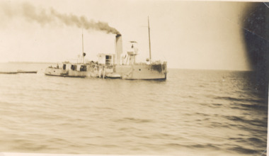 Lakes Entrance Historical Society
Photograph - Dredge W H Edgar, Gippsland Lakes Victoria, 1926
... Waterways...Black and white photograph of dredge W H Edgar in waterway Gippsland Lakes Victoria...Lakes Entrance Historical Society 4 Marine Parade Lakes Entrance gippsland Waterways Engineering Dredges Black and white photograph of dredge W H Edgar in waterway Gippsland Lakes Victoria Dredge W H Edgar, Gippsland Lakes Victoria Photograph Dredge W H Edgar, Gippsland Lakes Victoria ...Black and white photograph of dredge W H Edgar in waterway Gippsland Lakes Victoriawaterways, engineering, dredges -
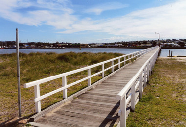 Lakes Entrance Historical Society
Photograph - Cunninghame Arm footbridge Lakes Entrance Victoria 2008
... ... Waterways...Colour photograph of the footbridge crossing Cunninghame Arm waterway, the township is in the foreground, Lakes Entrance, Victoria....Lakes Entrance Historical Society 4 Marine Parade Lakes Entrance gippsland Date made August 2008|This is the paired after photograph used in the 150 year Lakes Entrance 1858 - 2008 display. Bridges Waterways Township Colour photograph of the footbridge crossing Cunninghame Arm waterway, the township is in the foreground, Lakes Entrance, Victoria. ...Date made August 2008|This is the paired after photograph used in the 150 year Lakes Entrance 1858 - 2008 display.Colour photograph of the footbridge crossing Cunninghame Arm waterway, the township is in the foreground, Lakes Entrance, Victoria.bridges, waterways, township -
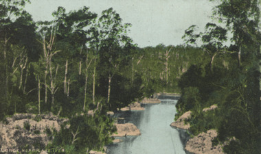 Lakes Entrance Historical Society
Postcard - Lake Tyers, E.J.B. Series, 1905c
... ... Waterways...Tinted postcard of a gorge showing a narrow waterway between rocky banks and thick vegetation near Lake Tyers Victoria...Lakes Entrance Historical Society 4 Marine Parade Lakes Entrance gippsland Also a black and white postcard of Lake Tyers Gippsland number 03823.1 size 9 x 13.5 cm purchased from B Roche Forest Waterways Gorge near Lake Tyers Tinted postcard of a gorge showing a narrow waterway between rocky banks and thick vegetation near Lake Tyers Victoria Postcard Lake Tyers E.J.B. ...Also a black and white postcard of Lake Tyers Gippsland number 03823.1 size 9 x 13.5 cm purchased from B RocheTinted postcard of a gorge showing a narrow waterway between rocky banks and thick vegetation near Lake Tyers VictoriaGorge near Lake Tyersforest, waterways -
Lakes Entrance Historical Society
Map - Broadbent Gippsland Lakes and Waterways
... ...Waterways...Road guide and directory for businesses from Paynesville to Lakes Entrance including Lake Tyers showing waterways...Lakes Entrance Historical Society 4 Marine Parade Lakes Entrance gippsland Businesses Waterways guide Road guide and directory for businesses from Paynesville to Lakes Entrance including Lake Tyers showing waterways Map Broadbent Gippsland Lakes and Waterways ...Road guide and directory for businesses from Paynesville to Lakes Entrance including Lake Tyers showing waterwaysbusinesses, waterways, guide -
Lakes Entrance Historical Society
Map - Area Map Bumberrah Kalimna Lakes Entrance
... ...Waterways...Map shows land owners, roads, forest, waterways of Bumberrah, Kalimna and Lakes Entrance. 2 pages...Lakes Entrance Historical Society 4 Marine Parade Lakes Entrance gippsland Roads and Streets Forest Waterways Map shows land owners, roads, forest, waterways of Bumberrah, Kalimna and Lakes Entrance. 2 pages Map Area Map Bumberrah Kalimna Lakes Entrance ...Map shows land owners, roads, forest, waterways of Bumberrah, Kalimna and Lakes Entrance. 2 pagesroads and streets, forest, waterways -
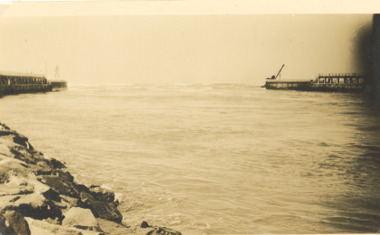 Lakes Entrance Historical Society
Photograph - The Entrance Lakes Entrance c1926, 1926c
... Waterways...Black and white photograph of entrance waterway Lakes Entrance Victoria. Also another view from Flagstaff...Lakes Entrance Historical Society 4 Marine Parade Lakes Entrance gippsland Waterways Piers Engineering Black and white photograph of entrance waterway Lakes Entrance Victoria. ...Black and white photograph of entrance waterway Lakes Entrance Victoria. Also another view from Flagstaffwaterways, piers, engineering -
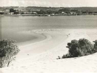 Lakes Entrance Historical Society
Photograph - Sand hummocks Lakes Entrance c1950
... Waterways...Also three photographs taken from similar location looking over waterway ...Lakes Entrance Historical Society 4 Marine Parade Lakes Entrance gippsland Waterways Vegetation Houses Township Black and white photograph taken from the sand hummocks looking across Cunninghame Arm waterway to jetties and buildings along Esplanade Lakes Entrance c1950 . ...Black and white photograph taken from the sand hummocks looking across Cunninghame Arm waterway to jetties and buildings along Esplanade Lakes Entrance c1950 . Also three photographs taken from similar location looking over waterway waterways, vegetation, houses, township