Showing 22 items matching "watsonia - maps"
-
 Greensborough Historical Society
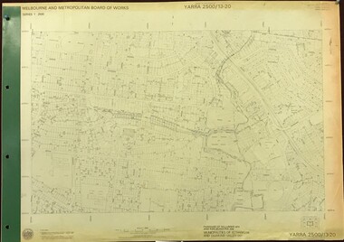
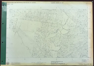
Map, Melbourne and Metropolitan Board of Works. Survey Division, MMBW, Yarra 2500 / 13.20. Greensborough, Montmorency and Watsonia, 1979_03
... ...watsonia - maps...Yarra 2500 [base map] 13-20. Greensborough, Montmorency and Watsonia. Parishes of Nillumbik 3310 and Keelbundora 2856. ...Greensborough, Montmorency and Watsonia. Map Map Melbourne and Metropolitan Board of Works. ...Melbourne and Metropolitan Board of Works. Yarra 2500 [base map] 13-20. Greensborough, Montmorency and Watsonia. Parishes of Nillumbik 3310 and Keelbundora 2856. Municipalities of Eltham 238 and Diamond Valley 257. Prominent streets include: Nell Street, Nepean Street and Alexandra Street. Includes Montmorency High School.MMBW Map in 1:2500 [scale] series. Cream parchment with green tape reinforcing on edges and punched holes on left edge.mmbw, melbourne and metropolitan board of works, shire of diamond valley, greensborough - maps, montmorency - maps, watsonia - maps -
 Greensborough Historical Society
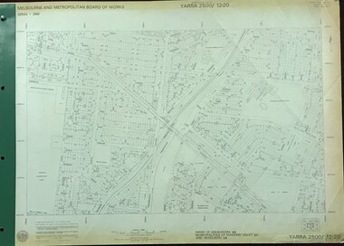
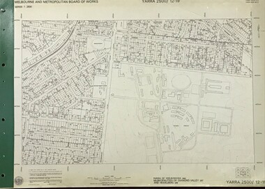
Map, Melbourne and Metropolitan Board of Works. Survey Division, MMBW, Yarra 2500 / 12.20. Watsonia Railway Station and environs, 1983_03
... ...watsonia - maps...map]. 12-20, Parishes of Keelbundora 2856, Municipalities of Diamond Valley 257 and 228. Shows street names, easement sizes, lot numbers, lodged plan numbers, names of prominent features, contour values, creek or river names. Watsonia...Includes former Watsonia Technical School and Gresswell Rehabilitation Centre sites. mmbw melbourne and metropolitan board of works shire of diamond valley watsonia - maps MMBW Map in 1:2500 [scale] series. ...Melbourne and Metropolitan Board of Works. Yarra 2500 [base map]. 12-20, Parishes of Keelbundora 2856, Municipalities of Diamond Valley 257 and 228. Shows street names, easement sizes, lot numbers, lodged plan numbers, names of prominent features, contour values, creek or river names. Watsonia Railway Station and environs. Prominent streets: Watsonia Road, Elder Street, Morwell Avenue and Nepean Street. Includes former Watsonia Technical School and Gresswell Rehabilitation Centre sites.MMBW Map in 1:2500 [scale] series. Cream parchment with green tape reinforcing on edges and punched holes on left edge.mmbw, melbourne and metropolitan board of works, shire of diamond valley, watsonia - maps -
 Greensborough Historical Society
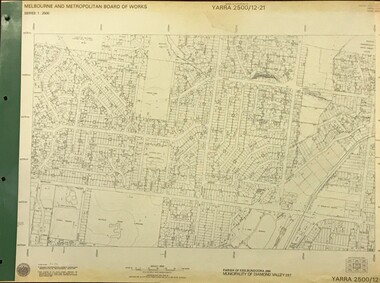
Map, Melbourne and Metropolitan Board of Works. Survey Division, MMBW, Yarra 2500 / 12.21. Watsonia North, 1979_02
... ...watsonia - maps...map]. 12-22, Parish of Keelbundora 2856, Municipality of Diamond Valley 257. Shows street names, easement sizes, lot numbers, lodged plan numbers, names of prominent features, contour values, creek or river names. Watsonia...MMBW, Yarra 2500 / 12.21. Watsonia North. Map Map Melbourne and Metropolitan Board of Works. ...Melbourne and Metropolitan Board of Works. Yarra 2500 [base map]. 12-22, Parish of Keelbundora 2856, Municipality of Diamond Valley 257. Shows street names, easement sizes, lot numbers, lodged plan numbers, names of prominent features, contour values, creek or river names. Watsonia Railway Station and environs. Prominent streets: Grimshaw Street, William Street and Macorna Street. Includes former Institute of Social Welfare (now Loyola College) Lines Reserve and Binnak Park.MMBW Map in 1:2500 [scale] series. Cream parchment with green tape reinforcing on edges and punched holes on left edge.mmbw, melbourne and metropolitan board of works, shire of diamond valley, watsonia - maps, bundoora - maps -
 Greensborough Historical Society
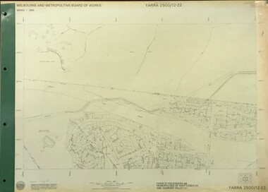
Map, Melbourne and Metropolitan Board of Works. Survey Division, MMBW, Yarra 2500 / 12.22. Watsonia North, 1978_03
... ...watsonia - maps...map]. 12-22, Parishes of Keelbundora 2856, Municipalities of Whittlesea 239 and Diamond Valley 257. Shows street names, easement sizes, lot numbers, lodged plan numbers, names of prominent features, contour values, creek or river names. Watsonia...MMBW, Yarra 2500 / 12.22. Watsonia North. Map Map Melbourne and Metropolitan Board of Works. ...Melbourne and Metropolitan Board of Works. Yarra 2500 [base map]. 12-22, Parishes of Keelbundora 2856, Municipalities of Whittlesea 239 and Diamond Valley 257. Shows street names, easement sizes, lot numbers, lodged plan numbers, names of prominent features, contour values, creek or river names. Watsonia Railway Station and environs. Prominent streets: Edmund Rice Parade and Macorna Street. Includes Christian Brothers Edmund Rice College and Janefield Special School sites and "proposed future freeway" (now Metropolitan Ring Road).MMBW Map in 1:2500 [scale] series. Cream parchment with green tape reinforcing on edges and punched holes on left edge.mmbw, melbourne and metropolitan board of works, shire of diamond valley, watsonia - maps, bundoora - maps -
 Greensborough Historical Society
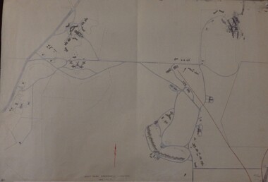
Map, Melbourne and Metropolitan Board of Works. Survey Division, MMBW, Yarra 2500 / 12.19. Watsonia, Simpson Army Barracks, 1983_03
... ...watsonia - maps...map]. 12-19, Parish of Keelbundora 2856, Municipalities of Diamond Valley 257 and 228. Shows street names, easement sizes, lot numbers, lodged plan numbers, names of prominent features, contour values, creek or river names. Watsonia...Prominent streets: Yallambie Road, Greensborough Road, and Strathallan Road. mmbw melbourne and metropolitan board of works shire of diamond valley watsonia - maps MMBW Map in 1:2500 [scale] series. ...Melbourne and Metropolitan Board of Works. Yarra 2500 [base map]. 12-19, Parish of Keelbundora 2856, Municipalities of Diamond Valley 257 and 228. Shows street names, easement sizes, lot numbers, lodged plan numbers, names of prominent features, contour values, creek or river names. Watsonia Barracks (Simpson Army Barracks) and environs. Prominent streets: Yallambie Road, Greensborough Road, and Strathallan Road. MMBW Map in 1:2500 [scale] series. Cream parchment with green tape reinforcing on edges and punched holes on left edge.mmbw, melbourne and metropolitan board of works, shire of diamond valley, watsonia - maps -
 Greensborough Historical Society
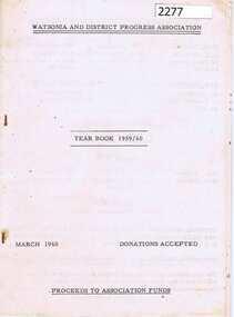
Booklet, Watsonia and District Progress Association, Watsonia and District Progress Association Year Book 1959/60, 1960_03
... 24 p. duplicated, stapled on white paper. With map of Watsonia insert....Greensborough Historical Society 34A Glenauburn Road Lower Plenty Lower Plenty melbourne This booklet provides a snapshot of Watsonia in the late 1950s and the improvements and advances in the area. watsonia watsonia and district progress association 24 p. duplicated, stapled on white paper. With map of Watsonia insert. ...This booklet provides a snapshot of Watsonia in the late 1950s and the improvements and advances in the area. 24 p. duplicated, stapled on white paper. With map of Watsonia insert.watsonia, watsonia and district progress association -
 Greensborough Historical Society
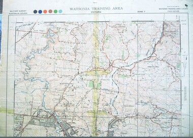
Map, Australian Government, Watsonia Training Area: Victoria: Zone 7, 1980c
... Map of Watsonia Training Area: Victoria: Zone 7. ...Coloured Map of Zone 7 Watsonia...Map of Watsonia Training Area: Victoria: Zone 7. ...Map of Watsonia Training Area: Victoria: Zone 7. This area is the location of Simpson Barracks. The map continues north through Greensborough.Coloured Map of Zone 7 Watsoniasimpson barracks, watsonia, greensborough -
![Work on paper - Newsletter, North East Link & Hurstbridge Railway Line: Community Update [Sept. 2020], 2020_09](/media/collectors/4f729f5697f83e03086015b8/items/6014eb092bef110c704f0fb5/item-media/6014eb9a2bef110c704f1691/item-fit-380x285.jpg?cb=6) Greensborough Historical Society
Greensborough Historical SocietyWork on paper - Newsletter, North East Link & Hurstbridge Railway Line: Community Update [Sept. 2020], 2020_09
... Includes a sketch map of Watsonia from Grimshaw Street to Lower Plenty Road....Includes a sketch map of Watsonia from Grimshaw Street to Lower Plenty Road. north east link hurstbridge rail line banyule city council watsonia 4 page leaflet, colour text and images. ...Banyule City Council comments on the North East Link and Hurstbridge Railway Line projects. This newsletter is to keep the community informed of developments and opportunities for consultation. Includes a sketch map of Watsonia from Grimshaw Street to Lower Plenty Road.4 page leaflet, colour text and images.north east link, hurstbridge rail line, banyule city council, watsonia -
 4th/19th Prince of Wales's Light Horse Regiment Unit History Room
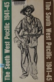
Book, Colonel E G Keogh M.B.E., E.D, The South West Pacific 1941-45, 1965
... Concise for Kokoda and Milne Bay including copy of battle maps, but also covers Singapore, Borneo, Philippines, Wewak and Bougainville, and more. Stamps and markings of previous owner - Defence Library Service, Watsonia Hard covered book, 479 pages, WW11 Australian soldier on front cover bearing sub-machine gun and pistol The South West Pacific 1941-45 Book Colonel E G Keogh M.B.E., E.D Grayflower Productions G M Capper City Service Press Pty Ltd ...A book on war in New Guinea and Islands providing a detailed overview of Australian forces participation in the Battle for Australia. Concise for Kokoda and Milne Bay including copy of battle maps, but also covers Singapore, Borneo, Philippines, Wewak and Bougainville, and more.Hard covered book, 479 pages, WW11 Australian soldier on front cover bearing sub-machine gun and pistolnon-fictionA book on war in New Guinea and Islands providing a detailed overview of Australian forces participation in the Battle for Australia. Concise for Kokoda and Milne Bay including copy of battle maps, but also covers Singapore, Borneo, Philippines, Wewak and Bougainville, and more.history, world war 2, south west pacific, keogh -
 Greensborough Historical Society
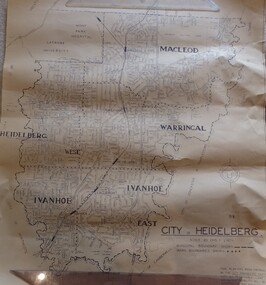
Map, City of Heidelberg. Engineers Dept, City of Heidelberg, 1960s
... Map of the City of Heidelberg from the Yarra River in the South to North of Watsonia Military Camp. ...Greensborough Historical Society 34A Glenauburn Road Lower Plenty Lower Plenty melbourne Map of the City of Heidelberg from the Yarra River in the South to North of Watsonia Military Camp. ...Map of the City of Heidelberg from the Yarra River in the South to North of Watsonia Military Camp. Shire of Diamond Valley is shown to the north.Map showing municipal and ward boundaries, black text on light brown paper."Scale: 20 CHS = to 1 IN"city of heidelberg -
 Greensborough Historical Society
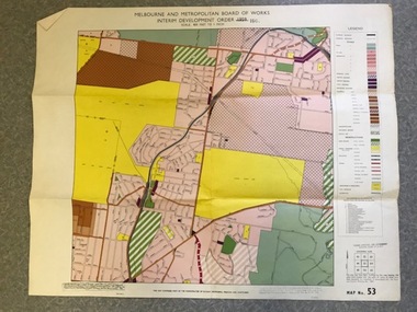
Map, Melbourne and Metropolitan Board of Works Interim Development Order 1961 Map No. 53, 27/09/1961
... watsonia Date printed on plan (1959) has been over stamped with 1961. Also stamped with Government Gazette date of 27.9.1961. "Scale 800 feet to 1 inch" Colour plan Melbourne and Metropolitan Board of Works Interim Development Order 1961 Map No. 53 Map Melbourne & Metropolitan Board of Works ...Denotes Zones and Reservations comprising part of the municipalities of Eltham, Heidelberg, Preston and Whittlesea, approved 27.9.61. Includes Mont Park Hospital and Watsonia Military Camp.Colour plan Date printed on plan (1959) has been over stamped with 1961. Also stamped with Government Gazette date of 27.9.1961. "Scale 800 feet to 1 inch"greensborough, watsonia -
 Greensborough Historical Society
Maps, Greensborough west of Plenty River, 1840o
... Comprises Sections 8, 9, 10, 14, 15, 16, 17, 18, 19, 20 Parish of Keelbundora greensborough watsonia lower plenty janefield One A4 photocopy, one A3 enlargement Greensborough west of Plenty River Maps ...Areas of Greensborough, west of the Plenty River, showing land holdings in the 1840s. Comprises Sections 8, 9, 10, 14, 15, 16, 17, 18, 19, 20 Parish of KeelbundoraOne A4 photocopy, one A3 enlargementgreensborough, watsonia, lower plenty, janefield -
 Greensborough Historical Society
Flyer - Leaflet, Watsonia Heights Primary School Fete 2020 WH4935, 14/03/2020
... Greensborough Historical Society 34A Glenauburn Road Lower Plenty Lower Plenty melbourne The Watsonia Primary School Fete, held on Saturday 14th March, was one of the last activities held before the Covid lockdown in 2020 watsonia primary school school fetes henry street greensborough Single page, printed in colour on front and black and white map of school on back. ...The Watsonia Primary School Fete, held on Saturday 14th March, was one of the last activities held before the Covid lockdown in 2020Single page, printed in colour on front and black and white map of school on back.watsonia primary school, school fetes, henry street greensborough -
 Greensborough Historical Society
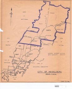
Map, City of Heidelberg, City of Heidelberg, 1962, 02/02/1962
... Map of City of Heidelberg showing boundaries of its six wards; North Ward is highlighted, covering Watsonia, Greensborough, part Bundoora, St Helena, Plenty, Yarrambat and Diamond Creek....Greensborough Historical Society 34A Glenauburn Road Lower Plenty Lower Plenty melbourne Map of City of Heidelberg showing boundaries of its six wards; North Ward is highlighted, covering Watsonia, Greensborough, part Bundoora, St Helena, Plenty, Yarrambat and Diamond Creek. city of heidelberg heidelberg - maps City of Heidelberg Scale: 1" to 1 ml. ...Map of City of Heidelberg showing boundaries of its six wards; North Ward is highlighted, covering Watsonia, Greensborough, part Bundoora, St Helena, Plenty, Yarrambat and Diamond Creek.Blue print mapCity of Heidelberg Scale: 1" to 1 ml. G.M.H. 2.2.62city of heidelberg, heidelberg - maps -
 Greensborough Historical Society
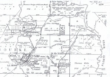
Maps, Mont Park, Gresswell, Larundel, 01/08/1949
... Greensborough Historical Society 34A Glenauburn Road Lower Plenty Lower Plenty melbourne Map of Mont Park area, including Larundel, Gresswell and Kingsbury Farm, between Plenty Road and Waiora Road, as at 1949, including buildings. mont park larundel gresswell watsonia kingsbury 49/147, R. ...Map of Mont Park area, including Larundel, Gresswell and Kingsbury Farm, between Plenty Road and Waiora Road, as at 1949, including buildings. Map of Mont Park area, including Larundel, Gresswell and Kingsbury Farm. Ink & pencil. Scale: 200': 1 inch49/147, R. G. H.mont park, larundel, gresswell watsonia, kingsbury -
 Greensborough Historical Society
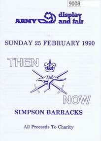
Booklet, Simpson Barracks, Then and now: Army display and fair 1990, 25/02/1990
... Greensborough Historical Society 34A Glenauburn Road Lower Plenty Lower Plenty melbourne Display and fair programme describing events with map of locations, held at Simpson Army Barracks 25/02/1990. australian army Watsonia army barracks simpson army barracks Paper 8 page booklet with programme and map. ...Display and fair programme describing events with map of locations, held at Simpson Army Barracks 25/02/1990.8 page booklet with programme and map.Paperaustralian army, watsonia army barracks, simpson army barracks -
 Greensborough Historical Society
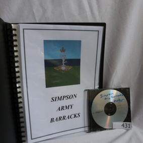
Folder and compact disc, Simpson Army Barracks, 2011_
... The suburb of Yallambie was formerly part of the Barracks. simpson army barracks watsonia barracks yallambie marilyn smith watsonia Black spiral bound folder (approx. 32 pages) with accompanying compact disc. Colour illustrations and maps. ...This document is the result of research into the history of Watsonia Barracks (now Simpson Barracks) by GHS member Marilyn Smith. It details the origin of street names in the surrounding area and includes biographical information on those after whom the streets were named. Updated December 2016.The Watsonia Barracks has been in use since WW2 and is today home to the Defence Force School of Signals. It was built on the property formerly owned by Ainslie Meares. In 1951, surrounding land was purchased for the extension of the barracks. The suburb of Yallambie was formerly part of the Barracks. Black spiral bound folder (approx. 32 pages) with accompanying compact disc. Colour illustrations and maps. Updated 2016 in Word document.simpson army barracks, watsonia barracks, yallambie, marilyn smith, watsonia -
 Greensborough Historical Society
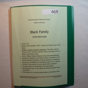
Folder, Black Family - Greensborough, 1900o
... Contents: Family tree; small school books from family member; copy of map and advertisement for Watsonia Electric Station Estate; receipts; cemetery information; article on James Black and descendants; copies of un-named photos taken on Bundoora farm....Greensborough Historical Society 34A Glenauburn Road Lower Plenty Lower Plenty melbourne Contents: Family tree; small school books from family member; copy of map and advertisement for Watsonia Electric Station Estate; receipts; cemetery information; article on James Black and descendants; copies of un-named photos taken on Bundoora farm. ...Contents: Family tree; small school books from family member; copy of map and advertisement for Watsonia Electric Station Estate; receipts; cemetery information; article on James Black and descendants; copies of un-named photos taken on Bundoora farm.The Black family owned a large portion of land from Greensborough to Watsonia. This collection is partly from family members.20-page plastic binder, green cover. Contains documents relating to the Black family of Greensborough and Watsonia.Collected by Greensborough Historical Society. Folder commenced 2012black family, shirley fraser, james black, watsonia electric station estate -
 Greensborough Historical Society
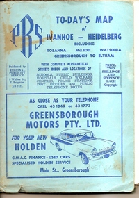
Map, To-day's Map of Ivanhoe - Heidelberg; including Rosanna, McLeod, Watsonia, Greensborough to Eltham, 1937-1953
... To-day's Map of Ivanhoe - Heidelberg; including Rosanna, McLeod, Watsonia, Greensborough to Eltham....Map of the suburbs of Ivanhoe, Heidelberg, Rosanna, Macleod, Watsonia, Greensborough and Eltham. ...To-day's Map of Ivanhoe - Heidelberg; including Rosanna, McLeod, Watsonia, Greensborough to Eltham. ...Map of the suburbs of Ivanhoe, Heidelberg, Rosanna, Macleod, Watsonia, Greensborough and Eltham. Dates to mid 1950s. An Advertiser on this map may be found in the Hurstbridge Advertiser Friday 17 December 1937, page 7: "Lyon Bros, of Eltham garage, suggest in their advertisement on the front page of this issue. that motorists should have their cars checked over by them before Christmas, so that any 5mall defects which might militate against the pleasure of the trip, might be remedied." As does "The Montsalvat Plant Farm" in The Age of Saturday 5 September 1953, page 48.Shows early streets and open space in these areas.Fold out map in pale blue cover. Cover dimensions: 21.5x15cm. Map is surrounded by advertising for local businesses.ivanhoe, maps, heidelberg, rosanna, macleod, watsonia, greensborough, eltham -
![Flyer - Newsletter, North East Link getting it right [June 2020], 2020_06](/media/collectors/4f729f5697f83e03086015b8/items/6014ef952bef110c704f3c4c/item-media/6014f0882bef110c704f42bf/item-fit-380x285.jpg?cb=6) Greensborough Historical Society
Greensborough Historical SocietyFlyer - Newsletter, North East Link getting it right [June 2020], 2020_06
... Includes a sketch map from the M80 Ring Road to Lower Plenty Road. north east link banyule city council watsonia 2 page leaflet, colour text and images. ...Banyule City Council comments on the North East Link project. This newsletter is to keep the community informed of developments. Includes a sketch map from the M80 Ring Road to Lower Plenty Road.2 page leaflet, colour text and images.north east link, banyule city council, watsonia -
 Greensborough Historical Society
Map, Melbourne and Metropolitan Board of Works. Survey Division, MMBW, Yarra 2500 / 13.19. Lower Plenty, Montmorency, Yallambie, 1979_02
... map] 13-19. Lower Plenty, Montmorency, Yallambie. Parishes of Keelbundora 2856 and Nillumbik 3310. Municipalities of Heidelberg 228, Diamond Valley 257 and Eltham 238. Prominent streets include: Elder Street, Para Road, and Main Road Lower Plenty. Includes Watsonia...map] 13-19. Lower Plenty, Montmorency, Yallambie. Parishes of Keelbundora 2856 and Nillumbik 3310. Municipalities of Heidelberg 228, Diamond Valley 257 and Eltham 238. Prominent streets include: Elder Street, Para Road, and Main Road Lower Plenty. Includes Watsonia ...Melbourne and Metropolitan Board of Works. Yarra 2500 [base map] 13-19. Lower Plenty, Montmorency, Yallambie. Parishes of Keelbundora 2856 and Nillumbik 3310. Municipalities of Heidelberg 228, Diamond Valley 257 and Eltham 238. Prominent streets include: Elder Street, Para Road, and Main Road Lower Plenty. Includes Watsonia Army Barracks.MMBW Map in 1:2500 [scale] series. Cream parchment with green tape reinforcing on edges and punched holes on left edge.mmbw, melbourne and metropolitan board of works, shire of diamond valley, montmorency - maps, yallambie - maps, lower plenty - maps -
 Greensborough Historical Society
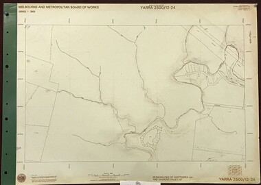
Map, Melbourne and Metropolitan Board of Works. Survey Division, MMBW, Yarra 2500 / 12.24. Plenty and Blue Lake, 1977_10
... map]. 12-24, Municipalities of Whittlesea 239 and Diamond Valley 257. Shows street names, easement sizes, lot numbers, lodged plan numbers, names of prominent features, contour values, creek or river names. Watsonia...map]. 12-24, Municipalities of Whittlesea 239 and Diamond Valley 257. Shows street names, easement sizes, lot numbers, lodged plan numbers, names of prominent features, contour values, creek or river names. Watsonia ...Melbourne and Metropolitan Board of Works. Yarra 2500 [base map]. 12-24, Municipalities of Whittlesea 239 and Diamond Valley 257. Shows street names, easement sizes, lot numbers, lodged plan numbers, names of prominent features, contour values, creek or river names. Watsonia Railway Station and environs. Prominent streets: Memorial Drive. Includes Plenty River and Blue Lake in the Plenty Gorge.MMBW Map in 1:2500 [scale] series. Cream parchment with green tape reinforcing on edges and punched holes on left edge.mmbw, melbourne and metropolitan board of works, shire of diamond valley, plenty - maps, blue lake