Showing 226 items matching "west avenue"
-
 Whitehorse Historical Society Inc.
Document, Alterations to be made in Street Names, 1932
... Shire of Blackburn and Mitcham from Shire Secretary to Chief Draughtsman of Titles, Melbourne, 15 Jul 1932. stating that the finalisation of the alteration of 'West India Avenue', Tunstall and 'West Avenue' will both be known as Milton Street....List of alterations to be made in street names - Shire of Blackburn and Mitcham from Shire Secretary to Chief Draughtsman of Titles, Melbourne, 15 Jul 1932. stating that the finalisation of the alteration of 'West India Avenue', Tunstall and 'West Avenue' will both be known as Milton Street....Whitehorse Historical Society Inc. 2-10 Deep Creek Road Mitcham melbourne Shire of Blackburn and Mitcham from Shire Secretary to Chief Draughtsman of Titles, Melbourne, 15 Jul 1932. stating that the finalisation of the alteration of 'West India Avenue', Tunstall and 'West Avenue' will both be known as Milton Street. ...List of alterations to be made in street namesList of alterations to be made in street names - Shire of Blackburn and Mitcham from Shire Secretary to Chief Draughtsman of Titles, Melbourne, 15 Jul 1932. stating that the finalisation of the alteration of 'West India Avenue', Tunstall and 'West Avenue' will both be known as Milton Street.List of alterations to be made in street names street names, shire of blackburn and mitcham -
 Ringwood and District Historical Society
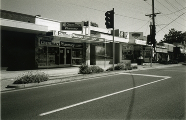
Photograph-B&W, Joan Walker, East Ringwood 2000- Shops in Railway Avenue looking West, 2000
... East Ringwood 2000- Shops in Railway Avenue looking West...East Ringwood 2000- Shops in Railway Avenue looking West- B&W Photo from Album 6501...Ringwood and District Historical Society 125A Warrandyte Road Ringwood North melbourne East Ringwood 2000- Shops in Railway Avenue looking West- B&W Photo from Album 6501 East Ringwood 2000- Shops in Railway Avenue looking West Photograph-B&W Joan Walker ...East Ringwood 2000- Shops in Railway Avenue looking West- B&W Photo from Album 6501 -
 Ringwood and District Historical Society
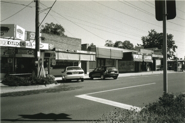
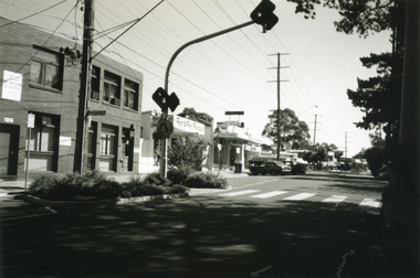
Photograph-B&W, Joan Walker, East Ringwood 2000- Railway Avenue looking West opposite the Railway Station, 2000
... East Ringwood 2000- Railway Avenue looking West opposite the Railway Station...East Ringwood 2000- Railway Avenue looking West opposite the Railway Station- B&W Photo from Album 6501...Ringwood and District Historical Society 125A Warrandyte Road Ringwood North melbourne East Ringwood 2000- Railway Avenue looking West opposite the Railway Station- B&W Photo from Album 6501 East Ringwood 2000- Railway Avenue looking West opposite the Railway Station Photograph-B&W Joan Walker ...East Ringwood 2000- Railway Avenue looking West opposite the Railway Station- B&W Photo from Album 6501 -
 Ringwood and District Historical Society
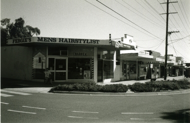
Photograph-B&W, Joan Walker, East Ringwood 2000-Cnr Laurence Grove & Railway Avenue looking West (Hairdresser on West Corner), 2000
... East Ringwood 2000-Cnr Laurence Grove & Railway Avenue looking West (Hairdresser on West Corner)...East Ringwood 2000-Cnr Laurence Grove & Railway Avenue looking West (Hairdresser on West Corner)- B&W Photo from Album 6501...Ringwood and District Historical Society 125A Warrandyte Road Ringwood North melbourne East Ringwood 2000-Cnr Laurence Grove & Railway Avenue looking West (Hairdresser on West Corner)- B&W Photo from Album 6501 East Ringwood 2000-Cnr Laurence Grove & Railway Avenue looking West (Hairdresser on West Corner) Photograph-B&W Joan Walker ...East Ringwood 2000-Cnr Laurence Grove & Railway Avenue looking West (Hairdresser on West Corner)- B&W Photo from Album 6501 -
 Ringwood and District Historical Society
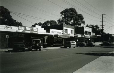
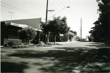
Photograph-B&W, Joan Walker, East Ringwood 2000- Railway Avenue looking West (Kirby Homecare,Wright Bros.Op Shop,& Bike Shop), 2000
... East Ringwood 2000- Railway Avenue looking West (Kirby Homecare,Wright Bros.Op Shop,& Bike Shop)...East Ringwood 2000- Railway Avenue looking West (Kirby Homecare,Wright Bros.Op Shop,& Bike Shop)- B&W Photo from Album 6501...Ringwood and District Historical Society 125A Warrandyte Road Ringwood North melbourne East Ringwood 2000- Railway Avenue looking West (Kirby Homecare,Wright Bros.Op Shop,& Bike Shop)- B&W Photo from Album 6501 East Ringwood 2000- Railway Avenue looking West (Kirby Homecare,Wright Bros.Op Shop,& Bike Shop) Photograph-B&W Joan Walker ...East Ringwood 2000- Railway Avenue looking West (Kirby Homecare,Wright Bros.Op Shop,& Bike Shop)- B&W Photo from Album 6501 -
 Ringwood and District Historical Society
Photograph-B&W, Joan Walker, East Ringwood 2000- Railway Avenue looking West (Dr's McCubbin,McDonald,Mc Neil,Ziccone,Worboys,Brownless) & Dentist O'Connor, 2000
... East Ringwood 2000- Railway Avenue looking West (Dr's McCubbin,McDonald,Mc Neil,Ziccone,Worboys,Brownless) & Dentist O'Connor...East Ringwood 2000- Railway Avenue looking West (Dr's McCubbin,McDonald,Mc Neil,Ziccone,Worboys,Brownless) & Dentist O'Connor- B&W Photo from Album 6501...Ringwood and District Historical Society 125A Warrandyte Road Ringwood North melbourne East Ringwood 2000- Railway Avenue looking West (Dr's McCubbin,McDonald,Mc Neil,Ziccone,Worboys,Brownless) & Dentist O'Connor- B&W Photo from Album 6501 East Ringwood 2000- Railway Avenue looking West (Dr's McCubbin,McDonald,Mc Neil,Ziccone,Worboys,Brownless) & Dentist O'Connor Photograph-B&W Joan Walker ...East Ringwood 2000- Railway Avenue looking West (Dr's McCubbin,McDonald,Mc Neil,Ziccone,Worboys,Brownless) & Dentist O'Connor- B&W Photo from Album 6501 -
Beechworth RSL Sub-Branch
Letter - Letter to relative
... Letter address to Mrs A.B Bristow 42 West Avenue Road, Hoe St Walthamstowe ...Beechworth RSL Sub-Branch 99 Ford Street Beechworth high-country Letter from Pte B A Bristow commander 2LT A H Ethinage to the next of kin Mrs B A Bristow advising that her husband was missing in action Soldier at war missing in action Letter address to Mrs A.B Bristow 42 West Avenue Road, Hoe St Walthamstowe Letter Letter to relative ...Letter from Pte B A Bristow commander 2LT A H Ethinage to the next of kin Mrs B A Bristow advising that her husband was missing in actionLetter address to Mrs A.B Bristow 42 West Avenue Road, Hoe St Walthamstowe soldier at war missing in action -
 Whitehorse Historical Society Inc.
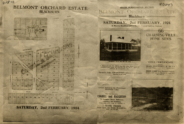
Document, Belmont Orchard Estate, 1924
... ...west avenue...Whitehorse Historical Society Inc. 2-10 Deep Creek Road Mitcham melbourne Original in 'Haughton Maps', La Trobe Library auctions belmont orchard estate patterson street nunawading central road joyce street lilian street west avenue Brochure for auction of Belmont Orchard Estate, Blackburn Brochure for auction of Belmont Orchard Estate, Blackburn, (now Nunawading) 66 sites, 2 February 1924. ...Brochure for auction of Belmont Orchard Estate, BlackburnBrochure for auction of Belmont Orchard Estate, Blackburn, (now Nunawading) 66 sites, 2 February 1924. Agents: Coghill & Haughton, Frank Fisher.Brochure for auction of Belmont Orchard Estate, Blackburnauctions, belmont orchard estate, patterson street, nunawading, central road, joyce street, lilian street, west avenue -
 Sunshine and District Historical Society Incorporated
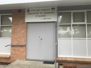
Photograph - St. Albans Photographs 2021, John Alchin, 2021
... ...West Esplanade...Douglas Avenue...Arthur Padley Alexina Street Arthur Street Conrad Street West Esplanade Douglas Avenue East Esplanade Furlong Road Alfrieda Street John Street Main Road East Main Road West Association of Ukrainians Chùa Hoàng Pháp Temple Croatian Seventh-Day Adventist Church Errington Reserve St. ...These photographs provide a visual record of assorted buildings, street views, and notable locations throughout St. Albans in 2021.This photograph collection documents St. Albans in 2021.5556.01 - Association of Ukrainians 16 Alexina St St. Albans 2021 Photo 01.JPG 5556.02 - Association of Ukrainians 16 Alexina St St. Albans 2021 Photo 02.JPG 5556.03 - Chùa Hoàng Pháp Temple 16 Arthur St St. Albans 2021 Photo 02.JPG 5556.04 - Conrad St 35 - 53 - Shops 2021 Photo 01.JPG 5556.05 - Conrad St 35 - 53 - Shops 2021 Photo 02.JPG 5556.06 - Croatian Seventh-Day Adventist Church West Esplanade St Albans 2021 Photo 01.JPG 5556.07 - Croatian Seventh-day Adventist Church West Esplanade St.Albans 2021.JPG 5556.08 - Douglas Ave 7 - 9 St. Albans - Former Shops 2021.JPG 5556.09 - East Esplanade 2 - 8 St. Albans 2021 Photo 01.JPG 5556.10 - Errington Reserve Adventure Playground 2021 Photo 01.JPG 5556.11 - Errington Reserve Community Sporting Rooms 2021 Photo 01.JPG 5556.12 - Errington Reserve Community Sports Pavilion 2021 Photo 01.JPG 5556.13 - Errington Reserve Memorial Gates 2021 Photo 01.JPG 5556.14 - Errington Reserve Memorial Gates 2021 Photo 03.JPG 5556.15 - Errington Reserve Memorial Gates 2021 Photo 04.JPG 5556.16 - Errington Reserve Memorial Gates 2021 Photo 05.JPG 5556.17 - Errington Reserve Path 2021 Photo 01.JPG 5556.18 - Errington Reserve Scout Club 2021 Photo 01.JPG 5556.19 - Errington Reserve Tennis Club 2021 Photo 01.JPG 5556.20 - Errington Reserve Tennis Club 2021 Photo 02.JPG 5556.21 - Errington Reserve Tennis Club 2021 Photo 03.JPG 5556.22 - Errington Reserve Tennis Club 2021 Photo 04.JPG 5556.23 - Furlong Rd St. Albans - Sunshine Hospital 2021 Photo 01.JPG 5556.24 - Furlong Rd St. Albans - Sunshine Hospital 2021 Photo 02.JPG 5556.25 - Grantham Green Hall St. Albans 2021 Photo 02.JPG 5556.26 - Greek Orthodox Community of St Albans 27 Arthur St St. Albans 2021 Photo 01.JPG 5556.27 - Grow Church 95 Alfrieda St St. Albans 2021 Photo 01.JPG 5556.28 - Jensens Funerals 2 Arthur St St. Albans 2021 Photo 01.JPG 5556.29 - Jensens Funerals 2 Arthur St St. Albans 2021 Photo 02.JPG 5556.30 - John Street St. Albans 2021 Photo 01.JPG 5556.31 - John Street St. Albans 2021 Photo 01John Street St. Albans 2021 Photo 02.JPG 5556.32 - John Street St. Albans 2021 Photo 03.JPG 5556.33 - Spare 5556.34 - Main Rd East 112 - Shop 2021 Photo 01.JPG 5556.35 - Main Rd East 172 - Service Station 2021 Photo 01.JPG 5556.36 - Main Rd East 202 - 206 - Shops 2021 Photo 01.JPG 5556.37 - Main Rd East 216 - 218 - Shops 2021 Photo 01.JPG 5556.38 - Main Rd East 330 St. Albans 2021 Photo 01.JPG 5556.39 - Main Rd West 45 St. Albans - Old Post Office Site 2021 Photo 01.JPG 5556.40 - Main Rd West 171 - 179b - Shops 2021 Photo 01.JPG 5556.41 - McKechnie Reserve St. Albans 2021 Photo 01.JPG 5556.42 - Padley's House Winifred St 2021 Photo 01.JPG 5556.43 - Padley's House Winifred St 2021 Photo 02.JPG 5556.44 - Padley's House Winifred St 2021 Photo 06.JPG 5556.45 - Saint Paraskevi, Saint Barbara and Saint John the Merciful Greek Orthodox Church St. Albans Photo 01.JPG 5556.46 - Serbian Orthodox Church of St George Kate St St. Albans 2021.JPG 5556.47 - St Albans Community Youth Club Main Rd East 2021 Photo 01.JPG 5556.48 - St Albans Community Youth Club Main Rd East 2021 Photo 02.JPG 5556.49 - St. Alban the Martyr Church of England East Esplanade St. Albans 2021 Photo 01.JPG 5556.50 - St. Alban the Martyr Church of England East Esplanade St. Albans 2021 Photo 03.JPG 5556.51 - St. Albans Bingo Centre Mckechnie Street St. Albans 2021 Photo 01.JPG 5556.52 - St. Albans Community Centre - The Bowery Theatre 22 Princess St St. Albans 2021 Photo 01.JPG 5556.53 - St. Albans Community Centre - The Bowery Theatre 22 Princess St St. Albans 2021 Photo 02.JPG 5556.54 - St. Albans Community Hall And Bowery Theatre 2021 Photo 01.JPG 5556.55 - St. Albans Hall East Esplanade St. Albans 2020 Photo 01.JPG 5556.56 - St. Albans Hotel McKechnie St St. Albans 2021 Photo 01.JPG 5556.57 - St. Albans Rail Reserve West Esplanade Grassland Reserve 2021 Photo 01.JPG 5556.58 - St. Albans Sacred Heart Catholic Church 2021 Photo 01.JPG 5556.59 - St. Albans Saint Soccer Club Churchill Reserve St. Albans 2021 Photo 01.JPG 5556.60 - St. Albans Senior Citizen Club 171 William St St. Albans 2021 Photo 02.JPG 5556.61 - St. Albans Senior Citizen Club 171 William St St. Albans 2021 Photo 04.JPG 5556.62 - St. Albans Square 2021 Photo 01.JPG 5556.63 - St. Albans Vietnamese Alliance Church West Esplanade St. Albans 2021 Photo 01.JPG 5556.64 - Stony Creek Head Waters Laurel Street Reserve St. Albans 2021 Photo 01.JPG 5556.65 - Theodore St 57 - 63 St. Albans 2021 Photo 01.JPG 5556.66 - Washington St 16 St. Albans - Half House 2021 Photo 01.JPG 5556.67 - Washington St 27 St. Albans - Half House 2021 Photo 01.JPG 5556.68 - West Esplanade Reserve 2021.JPG 5556.69 - William St 66 St. Albans - Shops 2021 Photo 01.JPG 5556.70 - William St 90 - 92 St. Albans - Shops 2021 Photo 01.JPG 5556.71 - Winifred St 12 St. Albans - Former Shop 2021 Photo 01.JPG arthur padley, alexina street, arthur street, conrad street, west esplanade, douglas avenue, east esplanade, furlong road, alfrieda street, john street, main road east, main road west, association of ukrainians, chùa hoàng pháp temple, croatian seventh-day adventist church, errington reserve, st. albans tennis club, sunshine hospital, grantham green hall, greek orthodox community of st albans, grow church, jensens funerals, kealba hotel, mckechnie reserve, saint paraskevi, saint barbara and saint john the merciful greek orthodox church, serbian orthodox church of st george, kate street, st albans community youth club, st. alban the martyr church of england, st. albans bingo centre, mckechnie street, st. albans community centre, the bowery theatre, st. albans hall, st. albans hotel, st. albans sacred heart catholic church, st. albans saint soccer club, churchill street, st. albans senior citizen club, william street, st. albans square 2021, st. albans vietnamese alliance church, stony creek head waters, laurel street, therodore street, washington street, half houses, winifred street -
Merbein District Historical Society
Newspaper, Sunraysia Daily (2 copies), 25 Mar.1969
... ... Paschendale Avenue... West...Merbein District Historical Society 36 Box St Merbein the-murray Storm Merbein South Dried fruits Ern Hillier Norm Beard Paschendale Avenue West Merbein Meridian Road Wargan Mr A. ...storm, merbein south, dried fruits, ern hillier, norm beard, paschendale avenue, west merbein, meridian road, wargan, mr a. tassone, george henry ball -
 Whitehorse Historical Society Inc.
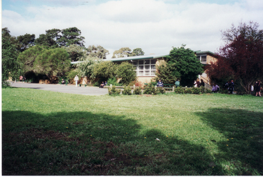
Photograph, Mitcham Primary School
... North windows. West entrance Tirana Avenue....North windows. West entrance Tirana Avenue. Mitcham Primary School Photograph Photograph ...Coloured photo of Mitcham Primary School. North windows. West entrance Tirana Avenue.mitcham primary school, no. 2904 -
 Phillip Island and District Historical Society Inc.
Photograph, 1978 - 79
... Large white building on the west corner of Thompson Avenue and The Esplanade, Cowes...It is now a Restaurant and Pizza outlet. local history photographs buildings historic buildings - historical coloured photograph john cook phillip island Cowes old Post Office Large white building on the west corner of Thompson Avenue and The Esplanade, Cowes Photograph ...Cowes Post Office built in 1909 with handmade bricks which were first used in the building of first Chicory Kiln in Cowes on Phillip Island in 1870 by the West brothers, Solomon and John. It is now a Restaurant and Pizza outlet.Large white building on the west corner of Thompson Avenue and The Esplanade, Coweslocal history, photographs, buildings, historic, buildings - historical, coloured photograph, john cook, phillip island, cowes old post office -
 Phillip Island and District Historical Society Inc.
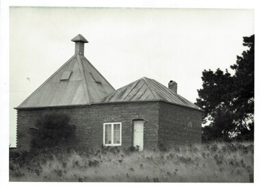
Photograph, Richardson's chicory kiln 1077-01
... John and Solomon West, in Thompson Avenue, Cowes, near the Esplanade and the second kiln was built in 1880 by Mr Joseph Richardson....John and Solomon West, in Thompson Avenue, Cowes, near the Esplanade and the second kiln was built in 1880 by Mr Joseph Richardson. ...In 1878, the first chicory kiln was built by Mr. John and Solomon West, in Thompson Avenue, Cowes, near the Esplanade and the second kiln was built in 1880 by Mr Joseph Richardson.HistoricalLarge black & white photo of a brick chicory kiln with a metal roof,door and window. In a paddock with large trees nearby.2nd chicory kiln on Phillip Island, now turned into a holiday house.chicory, chicory kilns, joseph richardson, -
 Kew Historical Society Inc
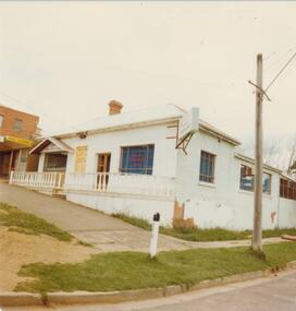
Photograph - Hard rubbish in the City of Kew
... . / Parkhill Road West of Adeney Avenue" In envelope marked: "Kew City Council / 12 photos / 1969 1979 18980 1985 / Unburnable rubbish units 18/1/80".... / Parkhill Road West of Adeney Avenue" In envelope marked: "Kew City Council / 12 photos / 1969 1979 18980 1985 / Unburnable rubbish units 18/1/80" Original black and white photographic positive of unburnable hard waste awaiting collection in Parkhill Road in the City of Kew. ...One of eight photographs donated by the City Engineer of the former City of Kew, mostly of hard rubbish clearance during the period 1969-1985.One of a dated series of photographs of core local government services as practised by the City of Kew in the period 1969-1985. Original black and white photographic positive of unburnable hard waste awaiting collection in Parkhill Road in the City of Kew.Reverse: "17th Nov 1969 8.45am. / Parkhill Road West of Adeney Avenue" In envelope marked: "Kew City Council / 12 photos / 1969 1979 18980 1985 / Unburnable rubbish units 18/1/80"garbage, hard rubbish, garbage removal, city of kew, local government -- city of kew, household waste, hard waste -
 Ballarat Heritage Services
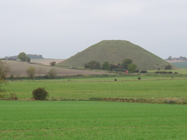
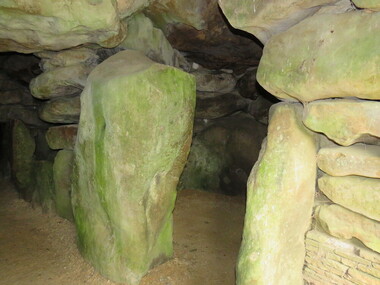
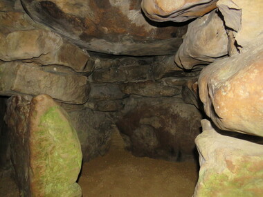
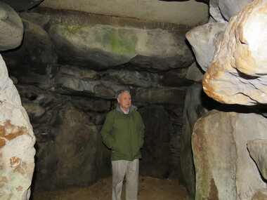
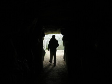
Photograph - Colour, Avebury World Heritage Site, Prehistoric Monuments, England, 2016
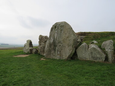
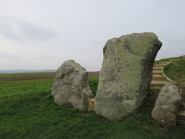
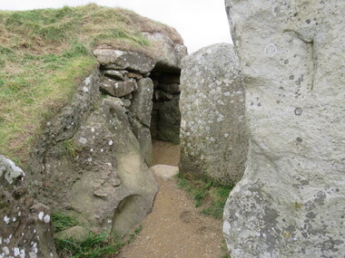
... The Avebury World Heritage Site is a complex of outstanding prehistoric monuments comprising Windmill Hill (Early Neolithic enclosure and Bronze Age burial mounds); Silbury Hill; West Kennet Long Barrow; Avebury Stone Circles and West Kennet Avenue; The Sanctuary (site of stone and timber circles). ...The Avebury World Heritage Site is a complex of outstanding prehistoric monuments comprising Windmill Hill (Early Neolithic enclosure and Bronze Age burial mounds); Silbury Hill; West Kennet Long Barrow; Avebury Stone Circles and West Kennet Avenue; The Sanctuary (site of stone and timber circles). ...Colour photograph of the Silbury Hill, an immense Neolithic man-made mound part of the Avebury World Heritage Site. The Avebury World Heritage Site is a complex of outstanding prehistoric monuments comprising Windmill Hill (Early Neolithic enclosure and Bronze Age burial mounds); Silbury Hill; West Kennet Long Barrow; Avebury Stone Circles and West Kennet Avenue; The Sanctuary (site of stone and timber circles). It is part of National Trust and English Heritage. Visitors may walk to sites.avebury world heritage site, mound, prehistoric monuments, silbury hill, west kennet long barrow, neolithic, world heritage -
 Ballarat Heritage Services
Photograph - Colour, Silbury Hill, Avebury World Heritage Site, Prehistoric Monuments, England, 2016
... The Avebury World Heritage Site is a complex of outstanding prehistoric monuments comprising Windmill Hill (Early Neolithic enclosure and Bronze Age burial mounds); Silbury Hill; West Kennet Long Barrow; Avebury Stone Circles and West Kennet Avenue; The Sanctuary (site of stone and timber circles). ...The Avebury World Heritage Site is a complex of outstanding prehistoric monuments comprising Windmill Hill (Early Neolithic enclosure and Bronze Age burial mounds); Silbury Hill; West Kennet Long Barrow; Avebury Stone Circles and West Kennet Avenue; The Sanctuary (site of stone and timber circles). ...Colour photograph of the Silbury Hill, an immense Neolithic man-made mound part of the Avebury World Heritage Site. The Avebury World Heritage Site is a complex of outstanding prehistoric monuments comprising Windmill Hill (Early Neolithic enclosure and Bronze Age burial mounds); Silbury Hill; West Kennet Long Barrow; Avebury Stone Circles and West Kennet Avenue; The Sanctuary (site of stone and timber circles). It is part of National Trust and English Heritage. Visitors may walk to sites.Colour photograph of rocks at Avebury World Heritage Site avebury world heritage site, prehistoric monuments, rocks -
 Ballarat Heritage Services
Photograph - Colour, Avebury World Heritage Site, Prehistoric Monuments, England, 2016
... The Avebury World Heritage Site is a complex of outstanding prehistoric monuments comprising Windmill Hill (Early Neolithic enclosure and Bronze Age burial mounds); Silbury Hill; West Kennet Long Barrow; Avebury Stone Circles and West Kennet Avenue; The Sanctuary (site of stone and timber circles). ...The Avebury World Heritage Site is a complex of outstanding prehistoric monuments comprising Windmill Hill (Early Neolithic enclosure and Bronze Age burial mounds); Silbury Hill; West Kennet Long Barrow; Avebury Stone Circles and West Kennet Avenue; The Sanctuary (site of stone and timber circles). ...Colour photograph of the Silbury Hill, an immense Neolithic man-made mound part of the Avebury World Heritage Site. The Avebury World Heritage Site is a complex of outstanding prehistoric monuments comprising Windmill Hill (Early Neolithic enclosure and Bronze Age burial mounds); Silbury Hill; West Kennet Long Barrow; Avebury Stone Circles and West Kennet Avenue; The Sanctuary (site of stone and timber circles). It is part of National Trust and English Heritage. Visitors may walk to sites.Colour photograph of Avebury World Heritage Stte.avebury world heritage site, prehistoric monuments, rocks -
 Ballarat Heritage Services
Photograph - Colour, Silbury Hill, Avebury World Heritage Site, Prehistoric Monuments, England, 2016
... The Avebury World Heritage Site is a complex of outstanding prehistoric monuments comprising Windmill Hill (Early Neolithic enclosure and Bronze Age burial mounds); Silbury Hill; West Kennet Long Barrow; Avebury Stone Circles and West Kennet Avenue; The Sanctuary (site of stone and timber circles). ...The Avebury World Heritage Site is a complex of outstanding prehistoric monuments comprising Windmill Hill (Early Neolithic enclosure and Bronze Age burial mounds); Silbury Hill; West Kennet Long Barrow; Avebury Stone Circles and West Kennet Avenue; The Sanctuary (site of stone and timber circles). ...Colour photograph of the Silbury Hill, an immense Neolithic man-made mound part of the Avebury World Heritage Site. The Avebury World Heritage Site is a complex of outstanding prehistoric monuments comprising Windmill Hill (Early Neolithic enclosure and Bronze Age burial mounds); Silbury Hill; West Kennet Long Barrow; Avebury Stone Circles and West Kennet Avenue; The Sanctuary (site of stone and timber circles). It is part of National Trust and English Heritage. Visitors may walk to sites.Colour photograph of Avebury World Heritage Site. avebury world heritage site, prehistoric monuments, rocks -
 Ballarat Heritage Services
Photograph - Colour, Avebury World Heritage Site, Prehistoric Monuments, England, 2016
... The Avebury World Heritage Site is a complex of outstanding prehistoric monuments comprising Windmill Hill (Early Neolithic enclosure and Bronze Age burial mounds); Silbury Hill; West Kennet Long Barrow; Avebury Stone Circles and West Kennet Avenue; The Sanctuary (site of stone and timber circles). ...The Avebury World Heritage Site is a complex of outstanding prehistoric monuments comprising Windmill Hill (Early Neolithic enclosure and Bronze Age burial mounds); Silbury Hill; West Kennet Long Barrow; Avebury Stone Circles and West Kennet Avenue; The Sanctuary (site of stone and timber circles). ...Colour photograph of the Silbury Hill, an immense Neolithic man-made mound part of the Avebury World Heritage Site. The Avebury World Heritage Site is a complex of outstanding prehistoric monuments comprising Windmill Hill (Early Neolithic enclosure and Bronze Age burial mounds); Silbury Hill; West Kennet Long Barrow; Avebury Stone Circles and West Kennet Avenue; The Sanctuary (site of stone and timber circles). It is part of National Trust and English Heritage. Visitors may walk to sites.Colour photograph of Avebury World Heritage Site.avebury world heritage site, rocks, prehistoric monuments -
 Ballarat Heritage Services
Photograph - Colour, Wayne Phillipson, Avebury World Heritage Site, Prehistoric Monuments, England, 2016
... The Avebury World Heritage Site is a complex of outstanding prehistoric monuments comprising Windmill Hill (Early Neolithic enclosure and Bronze Age burial mounds); Silbury Hill; West Kennet Long Barrow; Avebury Stone Circles and West Kennet Avenue; The Sanctuary (site of stone and timber circles). ...The Avebury World Heritage Site is a complex of outstanding prehistoric monuments comprising Windmill Hill (Early Neolithic enclosure and Bronze Age burial mounds); Silbury Hill; West Kennet Long Barrow; Avebury Stone Circles and West Kennet Avenue; The Sanctuary (site of stone and timber circles). ...Colour photograph of the Silbury Hill, an immense Neolithic man-made mound part of the Avebury World Heritage Site. The Avebury World Heritage Site is a complex of outstanding prehistoric monuments comprising Windmill Hill (Early Neolithic enclosure and Bronze Age burial mounds); Silbury Hill; West Kennet Long Barrow; Avebury Stone Circles and West Kennet Avenue; The Sanctuary (site of stone and timber circles). It is part of National Trust and English Heritage. Visitors may walk to sites.Colour photograph of the Avebury World Heritage Site.prehistoric monuments, avebury world heritage site, rocks -
 Ballarat Heritage Services
Photograph - Colour, Wayne Phillipson, Avebury World Heritage Site, Prehistoric Monuments, England, 2016
... The Avebury World Heritage Site is a complex of outstanding prehistoric monuments comprising Windmill Hill (Early Neolithic enclosure and Bronze Age burial mounds); Silbury Hill; West Kennet Long Barrow; Avebury Stone Circles and West Kennet Avenue; The Sanctuary (site of stone and timber circles). ...The Avebury World Heritage Site is a complex of outstanding prehistoric monuments comprising Windmill Hill (Early Neolithic enclosure and Bronze Age burial mounds); Silbury Hill; West Kennet Long Barrow; Avebury Stone Circles and West Kennet Avenue; The Sanctuary (site of stone and timber circles). ...Colour photograph of the Silbury Hill, an immense Neolithic man-made mound part of the Avebury World Heritage Site. The Avebury World Heritage Site is a complex of outstanding prehistoric monuments comprising Windmill Hill (Early Neolithic enclosure and Bronze Age burial mounds); Silbury Hill; West Kennet Long Barrow; Avebury Stone Circles and West Kennet Avenue; The Sanctuary (site of stone and timber circles). It is part of National Trust and English Heritage. Visitors may walk to sites.Colour photograph of Avebury World Heritage Site. avebury world heritage site, prehistoric monuments, rocks -
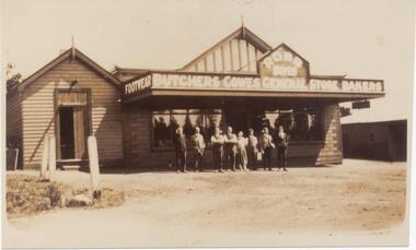 Phillip Island and District Historical Society Inc.
Photograph, Early 20th Century
... Sepia Photograph of Robb Bros General Store on the west side of Thompson Avenue, Cowes. "Footwear, Butchers, Cowes General Store, Bakers" across the front of the building. ...Phillip Island and District Historical Society Inc. phillip-island-and-the-bass-coast One of a collection of 6 photographs donated by Mary Karney robb bros general store cowes general stores cowes general store phillip island robb bros mary karney Sepia Photograph of Robb Bros General Store on the west side of Thompson Avenue, Cowes. "Footwear, Butchers, Cowes General Store, Bakers" across the front of the building. ...One of a collection of 6 photographs donated by Mary KarneySepia Photograph of Robb Bros General Store on the west side of Thompson Avenue, Cowes. "Footwear, Butchers, Cowes General Store, Bakers" across the front of the building. Eight people standing in front of the store.robb bros general store cowes, general stores, cowes general store phillip island, robb bros, mary karney -
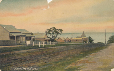 Phillip Island and District Historical Society Inc.
Photograph - Post Card, Early 20th Century
... Two Coloured postcards showing a Chicory Kiln, West's General Store & Bakery and three houses on the west side of Thompson Avenue, the main street in Cowes. ...Two Coloured postcards showing a Chicory Kiln, West's General Store & Bakery and three houses on the west side of Thompson Avenue, the main street in Cowes. ...One of a collection of 9 photographs donated by the former Shire of Phillip Island. Picture taken before the Golden Cypresses were planted in 1912. Two Coloured postcards showing a Chicory Kiln, West's General Store & Bakery and three houses on the west side of Thompson Avenue, the main street in Cowes. Westernport in the background. 2nd postcard Registration No. 191-02"Main Street, Cowes."thompson avenue, cowes phillip island, main street cowes phillip island, west's general store, cowes phillip island, shire of phillip island -
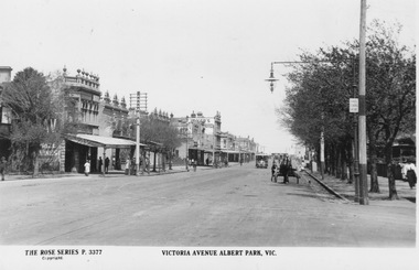 Melbourne Tram Museum
Postcard - Victoria Avenue, Albert Park, 1920s
... Photograph looks south west along Victoria Avenue towards the bay. A cable tram and horse drawn cart approach and numerous pedestrians walk along the footpaths, some under shop verandahs. ...Photograph looks south west along Victoria Avenue towards the bay. A cable tram and horse drawn cart approach and numerous pedestrians walk along the footpaths, some under shop verandahs. ...Photograph looks south west along Victoria Avenue towards the bay. A cable tram and horse drawn cart approach and numerous pedestrians walk along the footpaths, some under shop verandahs. A 'Hail Cars Here' sign is fixed the a lamp post front right, which were installed in the early 1920s by the new Melbourne and Metropolitan Tramways Board. Yields information about Albert Park Postcard with label below photograph and postcard markings on rear. On front: 'The Rose Series P 3377 Victoria Avenue, Albert Park, Vic'; on rear: 'Postcard - A real photograph. Produced in Australia'cable tram, victoria avenue, horse drawn cart, pedestrians, shop verandahs, hail cars here, lamp post, melbourne and metropolitan tramways board -
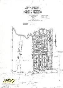 Ringwood and District Historical Society
Map - Plan of Subdivision, Part of Crown Allotment 4, Parish of Ringwood, County of Mornington - 1925
... Subdivision includes Grant Crescent, Heatherbrae Avenue, Bon View Avenue, Burwood Avenue, Sherbrook Avenue and Whitehorse Road, Ringwood, Victoria. Area west of Bon View Avenue marked Electrical Commission East, Excised....Subdivision includes Grant Crescent, Heatherbrae Avenue, Bon View Avenue, Burwood Avenue, Sherbrook Avenue and Whitehorse Road, Ringwood, Victoria. Area west of Bon View Avenue marked Electrical Commission East, Excised. ...Photocopy of subdivision with allotment numbers and property dimensions. Subdivision includes Grant Crescent, Heatherbrae Avenue, Bon View Avenue, Burwood Avenue, Sherbrook Avenue and Whitehorse Road, Ringwood, Victoria. Area west of Bon View Avenue marked Electrical Commission East, Excised.W.B. & O. McCutcheon Stamp 13.1.25. Declared by W.J. Bonwick 24.12.24. Councis's consent on plan with F.D3 report. LP Ref 10507. -
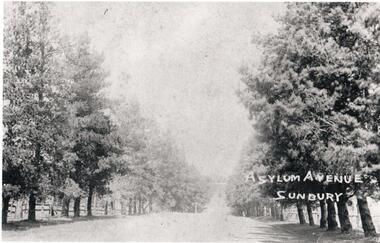 Hume City Civic Collection
Photograph, Asylum Avenue Sunbury
... At some stage oak trees were also planted along the avenue. In the late 1990s the trees along the west side of The Avenue were removed as a result of housing development. ...At some stage oak trees were also planted along the avenue. In the late 1990s the trees along the west side of The Avenue were removed as a result of housing development. ...This is a photograph of The Avenue leading to the Sunbury Asylum. it is lined with pine trees and post and rail fences. At some stage oak trees were also planted along the avenue. In the late 1990s the trees along the west side of The Avenue were removed as a result of housing development. They were later replaced.The Avenue was the main entrance leading to the former Sunbury AsylumA non-digital copy of a black and white photograph of a tree lined avenue with a white border. Unmounted.Written on the photo: Asylum Avenue/ Sunburysunbury asylum, trees, fences, the avenue, george evans collection -
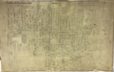 Kew Historical Society Inc
Map, MMBW, MMBW Plan No.65 Kew & Heidelberg, 1900-1910
... The map covers what was then the south central part of Kew, bordered on its north by Malmsbury Street, in the west by Florence Avenue, in the south by Barkers Road, and in the east by Princess Street. ...The map covers what was then the south central part of Kew, bordered on its north by Malmsbury Street, in the west by Florence Avenue, in the south by Barkers Road, and in the east by Princess Street. ...The Melbourne and Metropolitan Board of Works (MMBW) was established by an act of the Victorian Parliament in 1890 to prepare for and to implement a sewerage and water reticulation system across what was then inner Melbourne, its surrounding and middle distance suburbs, including Kew. The MMBW was disbanded in 1991.The map collection of the Kew Historical Society has at its core the historic maps assembled and originally stored in the City Engineer's Department of the City of Kew. These include maps in a number of scales. The vast majority of maps were produced by the MMBW in the first two decades of the twentieth century, and are solid working maps, backed by linen for durability. These maps are historically significant to Kew, the City of Boroondara and to the history of the development of state utilities in Victoria. A number of the Kew maps have additional details added by former municipal officers, including the levels reached by various floods. As these were working documents, information was added to them long after the period of their initial production and distribution.Early map of part of the Borough of Kew, created in the first decade of the twentieth century, at a scale 160 ft to 1 inch. The map covers what was then the south central part of Kew, bordered on its north by Malmsbury Street, in the west by Florence Avenue, in the south by Barkers Road, and in the east by Princess Street. The map shows the extent of urban development by that time, prominent institutions and the outlines of built structures in the municipality. Contour lines were added in ink to the map at a later stage.MELBOURNE AND METROPOLITAN BOARD OF WORKS / PLAN NO. 65 / KEW & HEIDELBERGmelbourne & metropolitan board of works, mmbw maps, mmbw plans, borough of kew, cartography -
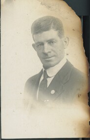 Brunswick Community History Group
Photograph - Charles Arthur John (Jack) Dollman, 1940c
... He died at his home 27 Fitzgibbon Avenue, West Brunswick in 1953 aged 73. Part of the Dollman colleciton. ...He died at his home 27 Fitzgibbon Avenue, West Brunswick in 1953 aged 73. Part of the Dollman colleciton. ...Fire damaged studio portrait of a middle aged male wearing a 2 piece dark suit, shirt with rounded collar and dark tie. He has been identified from other photographs as C A J Dollman (Charles Arthur John Dollman, known as Jack), Brunswick resident, Brunswick councillor 1945-1950 and member of the first Brunswick Historical Association, established in 1937. He died at his home 27 Fitzgibbon Avenue, West Brunswick in 1953 aged 73. Part of the Dollman colleciton.