Showing 374 items matching "west warrandyte"
-
 Ringwood and District Historical Society
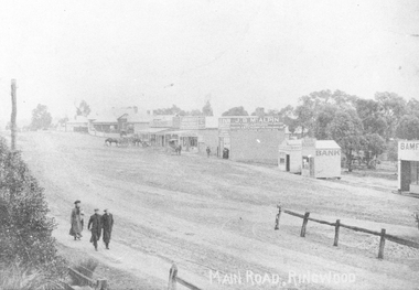
Photograph, Maroondah Highway Central, Ringwood. Looking west from Warrandyte Road, 1910
... Maroondah Highway Central, Ringwood. Looking west from Warrandyte Road, 1910....Written on rear of backing sheet of one photograph: "Main Road, Ringwood, looking west, Warrandyte Road coming in from right.". Image of central Ringwood including the E.S.& A. bank, Ringwood's first bank, 1910....Black and white photograph (2 copies) Maroondah Highway Central, Ringwood. Looking west from Warrandyte Road, 1910. Photograph ...Black and white photograph (2 copies)Written on rear of backing sheet of one photograph: "Main Road, Ringwood, looking west, Warrandyte Road coming in from right.". Image of central Ringwood including the E.S.& A. bank, Ringwood's first bank, 1910. -
 Ringwood and District Historical Society
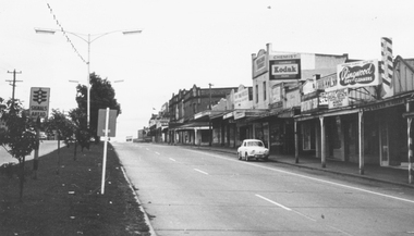
Photograph, Maroondah Highway, Ringwood. Looking west from Warrandyte Road - 1965
... Maroondah Highway, Ringwood. Looking west from Warrandyte Road - 1965. ...Typed under photograph: "Main Street, looking west from Warrandyte Rd. 1965"....Ringwood and District Historical Society 125A Warrandyte Road Ringwood North melbourne Typed under photograph: "Main Street, looking west from Warrandyte Rd. 1965". ...Black and white photograph (2 copies)Typed under photograph: "Main Street, looking west from Warrandyte Rd. 1965". -
 Ringwood and District Historical Society
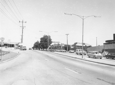
Photograph, Maroondah Highway Central, Ringwood. View looking west from Warrandyte Road - 1974
... View looking west from Warrandyte Road - 1974. ...Written on rear of backing sheet: "Maroondah Highway, 1974 - West from Warrandyte Rd. ext."...View looking west from Warrandyte Road - 1974. Photograph ...Black and white photographWritten on rear of backing sheet: "Maroondah Highway, 1974 - West from Warrandyte Rd. ext." -
 Eltham District Historical Society Inc
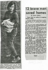
Newspaper clipping, "12 brave men saved homes," John Sorell, unidentified publication, 1965
... ...west warrandyte...About the 1965 bushfire at Laughing Water and West Warrandyte. Names referenced Ann Johnson, Betty Hosking, C.E. ...Eltham District Historical Society Inc 728 Main Rd Eltham melbourne About the 1965 bushfire at Laughing Water and West Warrandyte. Names referenced Ann Johnson, Betty Hosking, C.E. ...About the 1965 bushfire at Laughing Water and West Warrandyte. Names referenced Ann Johnson, Betty Hosking, C.E. Moss, Don Hosking, Dorothy Ruttledge, Ken Guest, Margot Bennett, Ray FreemanA4 photographic print from digital image of news clippinglaughing waters, eltham, west warrandyte, ann johnson, betty hosking, c.e. moss, don hosking, dorothy ruttledge, ken guest, margot bennett, ray freeman, poultry farm, alexander road, mulooka, bushfires -
 Ringwood and District Historical Society
Photograph, Maroondah Highway Central, Ringwood. Main Street, looking west from Warrandyte Rd, c1924
... Main Street, looking west from Warrandyte Rd, c1924....Typed below large photograph: "Main St looking west from Warrandyte Rd, c1924." Typed on back of one small photograph: "Coped from a circular for Mountain View Estate, J. ...Main Street, looking west from Warrandyte Rd, c1924. Photograph ...Black and white photograph (2 copies- 1 large, 2 small) Typed below large photograph: "Main St looking west from Warrandyte Rd, c1924." Typed on back of one small photograph: "Coped from a circular for Mountain View Estate, J. Press, vendor, Second Av. Kew. In Mullum Rd, 90 yds from Oban Rd. Press, Rangeview & Mountview Avenues. Winnington just completed. 1924." -
 Ringwood and District Historical Society
Photograph, South-west corner of Warrandyte and Oban Roads, North Ringwood, 1981
... South-west corner of Warrandyte and Oban Roads, North Ringwood, 1981...Written on back of photograph, "18/4/81. South-west corner of Warrandyte and Oban Roads"....South-west corner of Warrandyte and Oban Roads, North Ringwood, 1981 Photograph ...Written on back of photograph, "18/4/81. South-west corner of Warrandyte and Oban Roads". -
 Ringwood and District Historical Society
Photograph, Mullum Mullum Creek. West side of Warrandyte Road Bridge. Ringwood 1986
... Mullum Mullum Creek. West side of Warrandyte Road Bridge. Ringwood 1986...Mullum Mullum Creek. West side of Warrandyte Road Bridge."... side of Warrandyte Road Bridge." Mullum Mullum Creek. West side of Warrandyte Road Bridge. ...Written on back of photograph, "3.8.86. Ringwood. Mullum Mullum Creek. West side of Warrandyte Road Bridge." -
 Ringwood and District Historical Society
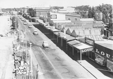
Photograph, Maroondah Highway Central, Ringwood. Looking west from Warrandyte Road, 1960
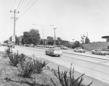
... Maroondah Highway Central, Ringwood. Looking west from Warrandyte Road, 1960....Written on back of photograph: "Maroondah Highway looking west near Pratt Street. Warrandyte Road on right....Warrandyte Road on right. Black and white photograph (2 copies) Maroondah Highway Central, Ringwood. Looking west ...Black and white photograph (2 copies)Written on back of photograph: "Maroondah Highway looking west near Pratt Street. Warrandyte Road on right. -
 Ringwood and District Historical Society
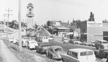
Photograph, Maroondah Highway Central, Ringwood. Looking west from Warrandyte Road, 1960. Taken from clock tower
... Maroondah Highway Central, Ringwood. Looking west from Warrandyte Road, 1960. Taken from clock tower....Black and white photograph (2 copies) Maroondah Highway Central, Ringwood. Looking west from Warrandyte Road, 1960. Taken from clock tower. ...Black and white photograph (2 copies)Written on back of one copy: "Maroondah Highway looking west from clock tower, 1960. Road being reconstructed." -
 Ringwood and District Historical Society
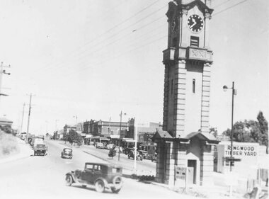
Photograph, Maroondah Highway Central, Ringwood. View looking west from Warrandyte Road- c1940's
... View looking west from Warrandyte Road- c1940's....Warrandyte Road. Black and white photograph Maroondah Highway Central, Ringwood. View looking west from Warrandyte Road- c1940's. ...Black and white photographImage shows clock tower at intersection of Maroondah Highway and Warrandyte Road. -
 Ringwood and District Historical Society
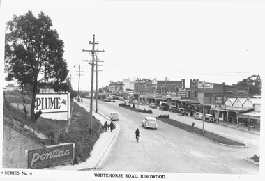
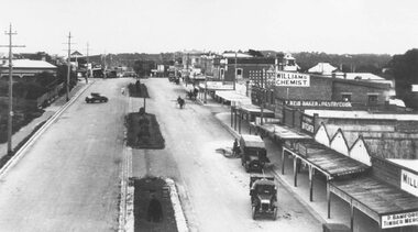
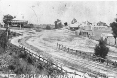
Photograph, Maroondah Highway Central, Ringwood. Whitehorse Road looking west from Warrandyte Road. c1930's
... Whitehorse Road looking west from Warrandyte Road. c1930's....Warrandyte Road railway bridge to Ringwood Street. Black and white photograph (2 copies) Maroondah Highway Central, Ringwood. Whitehorse Road looking west ...Black and white photograph (2 copies)Inscribed on photograph: "Series No 4. Whitehorse Road, Ringwood. Image shows shops on north side of road from Warrandyte Road railway bridge to Ringwood Street. -
 Ringwood and District Historical Society
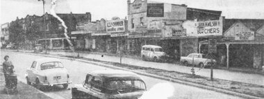
Photograph, Maroondah Highway Central, Ringwood. Main Street shops looking west from Warrandyte Road, c1950's
... Main Street shops looking west from Warrandyte Road, c1950's....Warrandyte Road and Adelaide Street. Newspaper clipping of black and white photograph. Maroondah Highway Central, Ringwood. Main Street shops looking west ...Newspaper clipping of black and white photograph.Image shows shops on north side of Whitehorse Road between Warrandyte Road and Adelaide Street. -
 Ringwood and District Historical Society
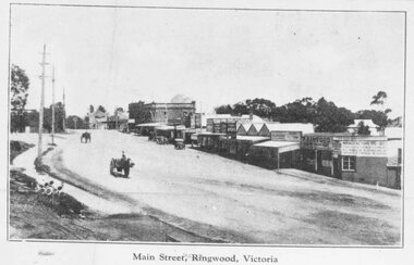
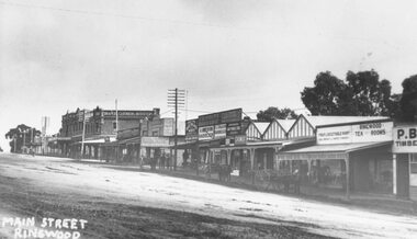
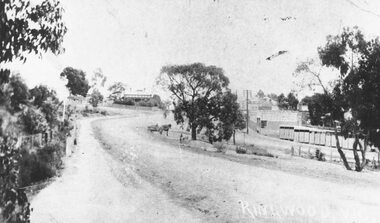
Photograph, Maroondah Highway Central, Ringwood. Main Street looking west from Warrandyte Road- c1920
... Main Street looking west from Warrandyte Road- c1920....Taken at the corner of Warrandyte Rd, looking west." All buildings in centre demolished for Eastland....Main Street looking west from Warrandyte Road- c1920. Photograph ...Black and white photograph (3 copies- 2 large, 1 small postcard)Written on back of photograph: "Main St Ringwood, c1920. Taken at the corner of Warrandyte Rd, looking west." All buildings in centre demolished for Eastland. -
 Ringwood and District Historical Society
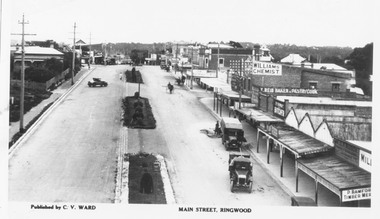
Photograph, Maroondah Highway Central, Ringwood. Main Street looking west from Warrandyte Road- c1920's
... Main Street looking west from Warrandyte Road- c1920's....Warrandyte Road Ringwood North melbourne Typed below photograph: "Published by C. V. Ward. Main Street, Ringwood". Image shows shops on right side of photograph. Median strip in centre of road. Both cars and horse-drawn vehicles in street. Black and white photograph Maroondah Highway Central, Ringwood. Main Street looking west ...Black and white photograph Typed below photograph: "Published by C. V. Ward. Main Street, Ringwood". Image shows shops on right side of photograph. Median strip in centre of road. Both cars and horse-drawn vehicles in street. -
 Ringwood and District Historical Society
Photograph, Maroondah Highway Central, Ringwood. Main Street looking west from Warrandyte Road- 1908
... Main Street looking west from Warrandyte Road- 1908....Warrandyte Rd coming in from right. Old Station Master's residence on left. Road had two levels here." Bank is E.S. & A. Agency. Bamford's Timber on right. Station Masters house on left. Black and white photograph (2 copies) Maroondah Highway Central, Ringwood. Main Street looking west ...Black and white photograph (2 copies)Written in lower right corner of photograph, "View near Railway Stn. Ringwood". Typed below one photograph: "Maroondah Hwy looking towards city with Warrandyte Rd coming in from right. Old Station Master's residence on left. Road had two levels here." Bank is E.S. & A. Agency. Bamford's Timber on right. Station Masters house on left. -
 Ringwood and District Historical Society
Photograph, Maroondah Highway Central, Ringwood. Main Street looking west from Warrandyte Road, 1928
... Main Street looking west from Warrandyte Road, 1928....Main Street looking west from Warrandyte Road, 1928. Photograph ...Black and white photographTyped below photograph: "Published by C.V. Ward. Main Street, Ringwood". Written on rear of backing sheet- looking west from old Clocktower site. -
 Ringwood and District Historical Society
Photograph, Maroondah Highway Central, Ringwood. View looking west from Warrandyte Road, 1974
... View looking west from Warrandyte Road, 1974. ...Warrandyte Rd., 1974". Black and white photograph Maroondah Highway Central, Ringwood. View looking west from Warrandyte Road, 1974. ...Black and white photographWritten on rear of backing sheet: "Maroondah Highway near corner Warrandyte Rd., 1974". -
 Ringwood and District Historical Society
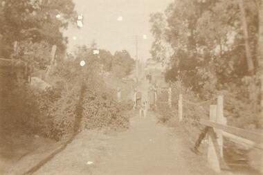
Photograph, Ringwood foot bridge, west side of Warrandyte Rd. 1919
... Ringwood foot bridge, west side of Warrandyte Rd. 1919...Ringwood and District Historical Society 125A Warrandyte Road Ringwood North melbourne Written on back of card, "Ringwood foot bridge, 1919". Ringwood foot bridge, west side of Warrandyte Rd. 1919 Photograph ...Written on back of card, "Ringwood foot bridge, 1919". -
 Ringwood and District Historical Society
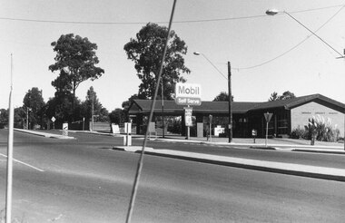
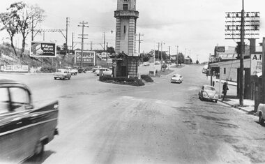
Photograph, Maroondah Highway Central, Ringwood. Clock tower at intersection of Warrandyte Road and Highway, c1960's
... Image shows Maroondah Highway looking west from Warrandyte Road....Ringwood and District Historical Society 125A Warrandyte Road Ringwood North melbourne Image shows Maroondah Highway looking west from Warrandyte Road. ...Black and white photograph (2 copies) Image shows Maroondah Highway looking west from Warrandyte Road. -
 Ringwood and District Historical Society
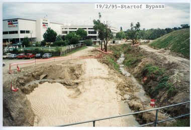
photograph, Eastlink Ringwood Bypass Construction-Start of Bypass 19/2/95
... Written on back of photo: "19/2/95-Start of Bypass Looking West from Warrandyte Rd"...Ringwood and District Historical Society 125A Warrandyte Road Ringwood North melbourne Written on back of photo: "19/2/95-Start of Bypass Looking West from Warrandyte Rd" Colour photograph Eastlink Ringwood Bypass Construction-Start of Bypass 19/2/95 photograph ...Colour photographWritten on back of photo: "19/2/95-Start of Bypass Looking West from Warrandyte Rd" -
 Ringwood and District Historical Society
Photograph, Maroondah Highway Central, Ringwood. Whitehorse Road looking west. 1908
... Typed below one photograph: "Maroondah Highway Ringwood looking west. Warrandyte Rd coming in from right. 1908." ...Ringwood and District Historical Society 125A Warrandyte Road Ringwood North melbourne Typed below one photograph: "Maroondah Highway Ringwood looking west. Warrandyte Rd coming in from right. 1908." ...Photographs (3 copies- 2 black and white, 1 sepia postcard).Typed below one photograph: "Maroondah Highway Ringwood looking west. Warrandyte Rd coming in from right. 1908." Written on back of another photograph: "Fence divides two levels of road opp Warrandyte Rd looking west. Station Master's house on left." -
 Ringwood and District Historical Society
Photograph, Maroondah Highway Central, Ringwood. Bamford's Timber Yard, c1920
... Written on back of photograph: "Bamford, west corner of Warrandyte Road and Main Street"....Ringwood and District Historical Society 125A Warrandyte Road Ringwood North melbourne Written on back of photograph: "Bamford, west corner of Warrandyte Road and Main Street". 2 copies of photograph (1 black and white, 1 smaller sepia) Maroondah Highway Central, Ringwood. ...2 copies of photograph (1 black and white, 1 smaller sepia)Written on back of photograph: "Bamford, west corner of Warrandyte Road and Main Street". -
 Ringwood and District Historical Society
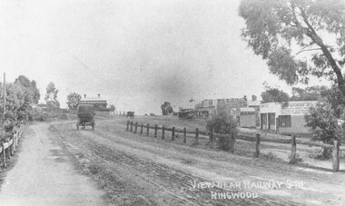
Photograph, Maroondah Highway Central, Ringwood. Main Street, c1909
... Image shows view of dirt road looking west from Warrandyte Road with shops on right, and Station Masters house in background. ...Ringwood and District Historical Society 125A Warrandyte Road Ringwood North melbourne Written on photograph: "Ringwood, Vic." Image shows view of dirt road looking west from Warrandyte Road with shops on right, and Station Masters house in background. ...Photograph (2 copies- 1 large black and white, 1 small sepia)Written on photograph: "Ringwood, Vic." Image shows view of dirt road looking west from Warrandyte Road with shops on right, and Station Masters house in background. Horse and dray in middle of road. -
 Ringwood and District Historical Society
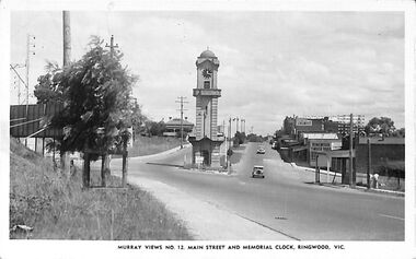
Postcard, Souvenir photograph - Murray Views No.12. Main Street and Memorial Clock, Ringwood, Vic
... Black and white "Murray Views" postcard and souvenir photograph - Ringwood Memorial Clocktower, looking west from cnr. Warrandyte Road and Maroondah Highway, Ringwood, Vic. ...Black and white "Murray Views" postcard and souvenir photograph - Ringwood Memorial Clocktower, looking west from cnr. Warrandyte Road and Maroondah Highway, Ringwood, Vic. ...Black and white "Murray Views" postcard and souvenir photograph - Ringwood Memorial Clocktower, looking west from cnr. Warrandyte Road and Maroondah Highway, Ringwood, Vic. Circa late 1940s.Printed on back - Post Card - Real Photographs produced in Australia by Murray Views, Gympie, Q. Handwritten - "1949 or 48". -
 Ringwood and District Historical Society
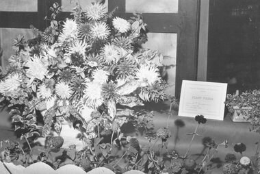
Photograph, Ringwood Horticultural Society- Ringwood Flower Show - 19 March 1959
... Goodwin had fifth shop in Main Street west of Warrandyte Rd. (Rly. other side of road.)...Ringwood and District Historical Society 125A Warrandyte Road Ringwood North melbourne Written on backing sheet, "1st Prize - Large floral window display at Goodwins Shoe Store. Mail 19 March 1959. Goodwin had fifth shop in Main Street west ...Black and white photographWritten on backing sheet, "1st Prize - Large floral window display at Goodwins Shoe Store. Mail 19 March 1959. Goodwin had fifth shop in Main Street west of Warrandyte Rd. (Rly. other side of road.) -
 Eltham District Historical Society Inc
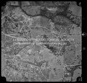
Photograph - Aerial Photograph, Landata, Research, Vic, Apr. 1972
... Centred on present day Main Road, Research near Maroondah Aqueduct and Eltham College bounded by Allendale Road to north, Research-Warrandyte Road to south, Swipers Gully Training Restaurant to east and Reynolds Road to west. ...Eltham District Historical Society Inc 728 Main Rd Eltham melbourne Centred on present day Main Road, Research near Maroondah Aqueduct and Eltham College bounded by Allendale Road to north, Research-Warrandyte Road to south, Swipers Gully Training Restaurant to east and Reynolds Road to west. ...Centred on present day Main Road, Research near Maroondah Aqueduct and Eltham College bounded by Allendale Road to north, Research-Warrandyte Road to south, Swipers Gully Training Restaurant to east and Reynolds Road to west. Historic Aerial Imagery Source: Landata.vic.gov.au Aerial Photo Details: Project No :985 Project : MELBOURNE 1972 Run : 26 Frame : 194 Date : 04/1972 Film Type : B/W Camera : RC10 Flying Height : 5700 Scale : 9600 Film Number : 2636 GDA2020 : 37°42'07"S, 145°11'07"E MGA2020 : 340015, 5825692 (55) Melways : 22 H1 (ed. 42)aerial photo, neil webster collection, 1972-04, allendale road, eltham college, main road, maroondah aqueduct, melway 22h1, research (vic.), research-warrandyte road, reynolds road, swiper's gully -
 Eltham District Historical Society Inc
Photograph - Digital Photograph, Alan King, St Andrews Anglican Church, St Andrews, 30 January 2008
... Queenstown’s first school was held in a tent after transferring from Andersons Creek, Warrandyte.6 From 1858 a church school, Caledonia Diggings, stood west of the main road, a quarter of a mile (0.4km) before Buttermans Track. ...Queenstown’s first school was held in a tent after transferring from Andersons Creek, Warrandyte.6 From 1858 a church school, Caledonia Diggings, stood west of the main road, a quarter of a mile (0.4km) before Buttermans Track. ...Built c.1868, St Andrew’s Anglican Church is Nillumbik Shire’s oldest timber church and is historically, socially, and spiritually significant to the Shire of Nillumbik. The church is historically significant because it may have given its name 'St Andrews' to the town (another suggestion is that the name came from the local hotel), it is also historically significant as one of only four buildings that remain from the Caledonian goldfields era of Queenstown (now St Andrews) and one of only a handful of buildings that survived the 1960s bushfires. The church is historically, socially, and spiritually significant because it has played an important part in community life for more than 150 years; a proposal to move the church in 1984 met with strenuous opposition. Much of the fires on Black Saturday 2009 were the north of the town. The town itself remained intact - as did this heritage building. Covered under Heritage Overlay, Nillumbik Planning Scheme. National Trust of Australia (Victoria) Local significance Published: Nillumbik Now and Then / Marguerite Marshall 2008; photographs Alan King with Marguerite Marshall.; p69 The St Andrews Anglican Church and former St Andrews Primary School, are two reminders of the district’s early days, when it was founded on gold. St Andrews, then called Queenstown, was the earliest goldfield in the Caledonia Diggings.1 It was the Upper Diamond Gold Mining and Administrative Centre, with 3000 miners. Queenstown was also the seat of the Court of Petty Sessions. The church and school then stood close to European and Chinese stores, three hotels, a brewery and a quartz mill.2 In 1861, Queenstown was officially proclaimed a township. From 1865, the name Queenstown was interchangeable with St Andrews, until 1952, when the town was officially named St Andrews. As gold declined from the early 1880s, Queenstown changed dramatically into a settlement of small farms. St Andrew’s Anglican Church, built in 1868, is the Shire’s oldest timber church and possibly gave its name to the township.3 The small timber church was opened on November 1, 1869, by the Dean of Melbourne. Anniversary tea meetings helped raise funds, and in 1889, a three-bedroom parsonage was built alongside. In 1910, the vicar, the Rev Selwyn Chase (and friend of the Scouting Movement’s founder, Baden Powell), established the 1st Queenstown Scout Troop, only two years after Scouting began in Australia. The church was important to the lives of many local residents who were baptised, married and had funeral services there. But by the 1950s the population had decreased and so did the weekly attendances. Around the mid-1960s the church closed, then fell into disrepair. So in the mid 1980s it was sold to the Education Department and was under threat of relocation or demolition. However this caused such opposition from locals,4 that instead, the Anglican church leased it as part of the Panton Hill parish5 and it was reconsecrated in 1987. Queenstown’s first school was held in a tent after transferring from Andersons Creek, Warrandyte.6 From 1858 a church school, Caledonia Diggings, stood west of the main road, a quarter of a mile (0.4km) before Buttermans Track. In 1882 the school was moved from a leased building, owned by headmaster Robert Harris, into a larger building on the corner of the School and the Heidelberg-Kinglake Roads. It had been moved from Smiths Gully and included a teacher’s three-roomed residence.7 In 1887 the school was replaced by the Queenstown State School No 128, although it was also called Caledonia Diggings until 1891. In 1956 it was renamed St Andrews. Still standing, this building is now used as the St Andrews Community Centre and the residence is leased for private use. The original timber-lined room remains alongside the extensions, and is distinctive with its high ceiling and tall small-paned windows. In 1984 a new school was built 500 metres west of the old school. Many residents have contributed much to St Andrews but one family that has done so for several generations is the Harris family. Robert Harris was an active member of the St Andrew’s Anglican Church, and worked hard at improving the town’s amenities until his death in 1887. He was a signatory to the successful 1863 petition to the Chief Commissioner of Police, against the proposed removal of the Court of Petty Sessions and police station at the Caledonia Diggings. The police station stayed in the town until 1917. Harris was Head Teacher of Queenstown State School from 1864 to 1874, then of the Smiths Gully school until it closed in 1882, and he continued teaching at Panton Hill until his death. His son, Robert Charles Harris, was editor and printer of the local newspaper, The Evelyn Observer, from 1873 until 1915. Robert’s son, William Shelley Harris, served in the Boer War and in World War One. In 1928 he became Kinglake National Park’s first park ranger. Robert’s daughter Elizabeth, taught needlework at Queenstown State School, and later ran the post office in Kinglake.This collection of almost 130 photos about places and people within the Shire of Nillumbik, an urban and rural municipality in Melbourne's north, contributes to an understanding of the history of the Shire. Published in 2008 immediately prior to the Black Saturday bushfires of February 7, 2009, it documents sites that were impacted, and in some cases destroyed by the fires. It includes photographs taken especially for the publication, creating a unique time capsule representing the Shire in the early 21st century. It remains the most recent comprehenesive publication devoted to the Shire's history connecting local residents to the past. nillumbik now and then (marshall-king) collection, st andrews, st andrews anglican church -
 Eltham District Historical Society Inc
Photograph, Looking west along Main Road at intersection with Research-Warrandyte Road, Research, c.1989, 1989
... Looking west along Main Road at intersection with Research-Warrandyte Road, Research, c.1989...Eltham District Historical Society Inc 728 Main Rd Eltham melbourne Infrastructure, Main Road, Research (Vic.), Research-Warrandyte Road, streets Kodak GA100 5095 Roll of 35mm colour negative film, 5 strips Looking west along Main Road at intersection with Research-Warrandyte Road, Research, c.1989 Photograph ...Roll of 35mm colour negative film, 5 strips Kodak GA100 5095infrastructure, main road, research (vic.), research-warrandyte road, streets -
 Eltham District Historical Society Inc
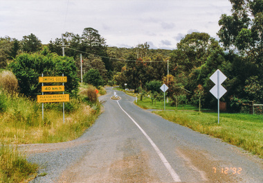
Photograph, Smiths Gully Road looking west near Joyce Road, Smiths Gully, 7 December 1992, 07/12/1992
... Eltham District Historical Society Inc 728 Main Rd Eltham melbourne The Eltham Horse Trail: Research and Warrandyte to Kinglake: Survey of proposed route, December 1992: (3) Kangaroo Ground to Kinglake eltham horse trail (1992 survey) smiths gully joyce road smiths gully road Colour photograph Smiths Gully Road looking west near Joyce Road, Smiths Gully, 7 December 1992 Photograph ...The Eltham Horse Trail: Research and Warrandyte to Kinglake: Survey of proposed route, December 1992: (3) Kangaroo Ground to KinglakeColour photographeltham horse trail (1992 survey), smiths gully, joyce road, smiths gully road -
 Eltham District Historical Society Inc
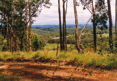
Photograph, Looking west from Fox Road, Smiths Gully, 7 December 1992, 07/12/1992
... Eltham District Historical Society Inc 728 Main Rd Eltham melbourne The Eltham Horse Trail: Research and Warrandyte to Kinglake: Survey of proposed route, December 1992: (3) Kangaroo Ground to Kinglake eltham horse trail (1992 survey) smiths gully fox road Colour photograph Looking west from Fox Road, Smiths Gully, 7 December 1992 Photograph ...The Eltham Horse Trail: Research and Warrandyte to Kinglake: Survey of proposed route, December 1992: (3) Kangaroo Ground to KinglakeColour photographeltham horse trail (1992 survey), smiths gully, fox road